

Exhibit 99.1
|
|
| Technical Report on the Patterson | |
| Lake North Project, Northern | |
| Saskatchewan, Canada | |
| Report for NI 43-101 | |
| F3 Uranium Corp. | |
| SLR Project No.: 138.21599.00001 | |
| Effective Date: | |
| November 20, 2023 | |
| Signature Date: | |
| January 25, 2023 | |
| Prepared by: | |
| SLR International Corporation | |
| Qualified Persons: | |
| Mark B. Mathisen, C.P.G | |
| Making Sustainability Happen | |
 |
| F3 Uranium Corp. | Patterson Lake North Project | January 25, 2023 |
| Report for NI 43-101 | SLR Project No.: 138.21599.00001 |
| Technical Report on the Patterson Lake North Project, Northern Saskatchewan, Canada |
| SLR Project No.: 138.21599.00001 |
| Prepared by |
| SLR International Corporation |
| 1658 Cole Blvd, Suite 100 |
| Lakewood, CO 80401 |
| for |
| F3 Uranium Corp. |
| 750 – 1620 Dickson Avenue |
| Kelowna, BC |
| V1Y 9Y2 Canada |
| Effective Date - November 20, 2023 |
| Signature Date - January 25, 2023 |
| Prepared by: | Approved by: |
| Mark B. Mathisen, C.P.G | |
| Project Manager | |
| Peer Reviewed by: | Mark B. Mathisen, C.P.G |
| Valerie Wilson, M.Sc., P.Geo. | |
| Project Director | |
| Grant A. Malensek, M.Eng., P.Eng. | |
| Distribution: | 1 copy - F3 Uranium Corp. |
| 1 copy - SLR International Corporation |
|
| F3 Uranium Corp. | Patterson Lake North Project | January 25, 2023 |
| Report for NI 43-101 | SLR Project No.: 138.21599.00001 |
Table of Contents
| 1.0 | Summary | 1-1 |
| 1.1 | Executive Summary | 1-1 |
| 1.2 | Technical Summary | 1-2 |
| 2.0 | Introduction | 2-1 |
| 2.1 | Sources of Information | 2-1 |
| 2.2 | List of Abbreviations | 2-3 |
| 3.0 | Reliance on Other Experts | 3-1 |
| 4.0 | Property Description and Location | 4-1 |
| 4.1 | Location | 4-1 |
| 4.2 | Land Tenure | 4-3 |
| 4.3 | Required Permits | 4-7 |
| 4.4 | Encumbrances | 4-7 |
| 4.5 | Royalties | 4-7 |
| 5.0 | Accessibility, Climate, Local Resources, Infrastructure and Physiography | 5-1 |
| 5.1 | Accessibility | 5-1 |
| 5.2 | Climate | 5-1 |
| 5.3 | Local Resources | 5-2 |
| 5.4 | Infrastructure | 5-2 |
| 5.5 | Physiography | 5-2 |
| 6.0 | History | 6-1 |
| 6.1 | Prior Ownership | 6-1 |
| 6.2 | Exploration and Development History | 6-4 |
| 6.3 | Historical Resource/Reserve Estimates | 6-13 |
| 6.4 | Past Production | 6-13 |
| 7.0 | Geological Setting and Mineralization | 7-1 |
| 7.1 | Regional Geology | 7-1 |
| 7.2 | Local Geology | 7-4 |
| 7.3 | Property Geology | 7-6 |
| 7.4 | Mineralization | 7-8 |
| 8.0 | Deposit Types | 8-1 |
| 9.0 | Exploration | 9-1 |
| 10.0 | Drilling | 10-1 |
| i | |
| F3 Uranium Corp. | Patterson Lake North Project | January 25, 2023 |
| Report for NI 43-101 | SLR Project No.: 138.21599.00001 |
| 10.1 | Patterson Lake North Project | 10-5 |
| 10.2 | Drilling Methodology and Procedures | 10-9 |
| 11.0 | Sample Preparation, Analyses, and Security | 11-1 |
| 11.1 | Sample Preparation | 11-1 |
| 11.2 | Drill Core Geochemistry Analysis | 11-2 |
| 11.3 | Drill Core PIMA Analysis | 11-2 |
| 11.4 | Soil Sample Analysis | 11-2 |
| 11.5 | Drill Core Bulk Density Analysis | 11-3 |
| 11.6 | Quality Assurance and Quality Control | 11-3 |
| 11.7 | Sample Security | 11-14 |
| 11.8 | QP Opinion on Section 11 | 11-15 |
| 12.0 | Data Verification | 12-1 |
| 12.1 | Data Verification Process | 12-1 |
| 13.0 | Mineral Processing and Metallurgical Testing | 13-1 |
| 14.0 | Mineral Resource Estimate | 14-1 |
| 15.0 | Mineral Reserve Estimate | 15-1 |
| 16.0 | Mining Methods | 16-1 |
| 17.0 | Recovery Methods | 17-1 |
| 18.0 | Project Infrastructure | 18-1 |
| 19.0 | Market Studies and Contracts | 19-1 |
| 20.0 | Environmental Studies, Permitting, and Social or Community Impact | 20-1 |
| 21.0 | Capital and Operating Costs | 21-1 |
| 22.0 | Economic Analysis | 22-1 |
| 23.0 | Adjacent Properties | 23-1 |
| 24.0 | Other Relevant Data and Information | 24-1 |
| 25.0 | Interpretation and Conclusions | 25-1 |
| 26.0 | Recommendations | 26-1 |
| 27.0 | References | 27-1 |
| 28.0 | Date and Signature Date | 28-1 |
| 29.0 | Certificate of Qualified Person | 29-1 |
| 29.1 | Mark B. Mathisen | 29-1 |
| ii | |
| F3 Uranium Corp. | Patterson Lake North Project | January 25, 2023 |
| Report for NI 43-101 | SLR Project No.: 138.21599.00001 |
Tables
| Table 1-1: | PLN 2024 Exploration Budget | 1-2 |
| Table 4-1: | Land Tenure – Patterson Lake North | 4-3 |
| Table 4-2: | Land Tenure – Minto Property | 4-3 |
| Table 4-3: | Land Tenure – Broach Property | 4-4 |
| Table 5-1: | Climatic Data – Cluff Lake, Fort Chipewyan, and Fort MacKay | 5-2 |
| Table 6-1: | Summary of Ownership | 6-2 |
| Table 10-1: | PLN Project Drill Hole Summary | 10-2 |
| Table 10-2: | PLN Property Significant Drill Hole Intercepts | 10-3 |
| Table 11-1: | Summary of QA/QC Source and Type by Year | 11-4 |
| Table 11-2: | Summary of QA/QC Sampling Insertions by Year | 11-5 |
| Table 11-3: | Expected Values and Standard Deviation of CRMs | 11-8 |
| Table 26-1: | PLN 2024 Exploration Budget | 26-1 |
Figures
| Figure 1-1: | PLN Winter 2024 Exploration Target Map | 1-6 |
| Figure 1-2: | PLN JR Zone Winter 2024 Drill Hole Exploration Map | 1-7 |
| Figure 4-1: | Location Map | 4-2 |
| Figure 4-2: | Land Tenure | 4-6 |
| Figure 7-1: | Geological Sketch Map of the Athabasca Basin | 7-2 |
| Figure 7-2: | Local Geology Map | 7-5 |
| Figure 7-3: | Property Geology Map | 7-7 |
| Figure 7-4: | PLN Cross Section | 7-9 |
| Figure 8-1: | Illustrations of Various Models for Unconformity Type Deposits of the Athabasca Basin | 8-3 |
| Figure 10-1: | Drill Hole Location Map | 10-4 |
| Figure 11-1: | Uranium CRM Z-Score Control Chart | 11-9 |
| Figure 11-2: | Field Duplicate Control Chart | 11-10 |
| Figure 11-3: | Preparation Duplicate Control Chart | 11-11 |
| Figure 11-4: | Pulp Duplicate Control Chart | 11-12 |
| Figure 11-5: | Blank Control Chart | 11-13 |
| Figure 23-1: | Adjacent Properties | 23-2 |
| iii | |
| F3 Uranium Corp. | Patterson Lake North Project | January 25, 2023 |
| Report for NI 43-101 | SLR Project No.: 138.21599.00001 |
| 1.0 | Summary |
| 1.1 | Executive Summary |
SLR International Corporation (SLR) was retained by F3 Uranium Corp. (F3 Uranium or the Company) for the completion of a NI 43-101 Technical Report (the Technical Report) on the Patterson Lake North (PLN) Project, located in northern Saskatchewan, Canada. The PLN Project comprises three properties: the PLN Property, which includes the JR Zone, the Minto Property (Minto), and the Broach Property (Broach), collectively, the Properties. The Properties are undeveloped, and no Mineral Resources have been yet defined. The purpose of this Technical Report is to provide information on the recent exploration discovery of uranium mineralization within the JR Zone, and to provide an update of exploration activities and results at the Property.
F3 Uranium (formerly Fission 3.0 Corp) was incorporated in October 2013 as a fully owned subsidiary of Fission Uranium Corp. (Fission Uranium). In November 2013, Fission 3.0 Corp. completed a plan of arrangement involving Alpha Mineral Inc. (Alpha) and Fission Uranium pursuant to which Fission Uranium acquired Alpha’s Minerals’ 50% interest in the Patterson Lake South (PLS) project. As a result of the transaction, certain properties and assets of Fission Uranium, including the PLN Project, became assets of F3 Uranium. F3 Uranium is no longer a wholly owned subsidiary of Fission Uranium.
| 1.1.1 | Conclusions |
SLR offers the following interpretations and conclusions on the Project:
| ● | The PLN Project shows excellent potential for economic uranium mineralization and further exploration work is warranted. |
| ● | The JR Zone deposit is considered an example of a basement-hosted vein-type or fracture-filled type uranium deposit. |
| ● | To date, F3 Uranium and its predecessors have completed a total of 143 drill holes, totaling 49,945 m across the PLN Project. |
| ● | In the SLR QP’s opinion, the logging and sampling procedures meet or exceed industry standards and are adequate for Mineral Resource estimation. |
| ● | SLR reviewed and verified the resource database, including a review of the quality assurance (QA) and quality control (QC) methods and results, verifying assay certificates against the database assay table, standard database validation tests, and one site visit, including a drill core review. No limitations were placed on SLR’s data verification process. |
| ● | Based on the data validation and the results of the standard, blank, and duplicate analyses, the SLR QP is of the opinion that the sampling methods, chain of custody procedures, and analytical techniques are appropriate and meet acceptable industry standards. |
| ● | The assay and bulk density databases are of sufficient quality for Mineral Resource estimation at the JR Zone. |
| ● | Uranium mineralization at the PLN Property is hosted primarily within veins or fracture- filled metamorphosed basement lithologies and, to a much lesser extent, within overlying sedimentary rocks. Uranium mineralization has been intersected by surface drilling along two primary EM (electromagnetic) conductor trends: the A1 main shear zone (host of the JR Zone deposit) and B1 shear zone, which have a combined strike length of roughly 3.6 km. |
| 1-1 | |
| F3 Uranium Corp. | Patterson Lake North Project | January 25, 2023 |
| Report for NI 43-101 | SLR Project No.: 138.21599.00001 |
| 1.1.2 | Recommendations |
F3 Uranium has proposed a total budget of C$14.60 million, as presented in Table 1-1, to advance the JR Zone and explore the remainder of the Project. SLR has reviewed and agrees with the proposed work plan.
| Table 1-1: | PLN 2024 Exploration Budget |
| Category | Item | Budget (C$) |
| Exploration | Drill testing of Broach Property | 2,500,000 |
| Drill testing of Minto Property | 1,500,000 | |
| Drill testing of B1 | 4,000,000 | |
| Exploration Subtotal | 8,000,000 | |
| JR Zone | Infill and Delineation drilling JR Zone | 6,500,000 |
| NI 43-101 Resource Estimate | 100,000 | |
| JR Zone Subtotal | 6,600,000 | |
| Total | 14,600,000 |
| 1.2 | Technical Summary |
| 1.2.1 | Property Description, Location, and Land Tenure |
The PLN, Minto, and Broach properties are located in northern Saskatchewan, approximately 550 km north-northwest of the city of Prince Albert and 150 km north of the community of La Loche. The three Properties are collectively referred to as the Patterson Lake North Project.
The PLN Property comprises two adjacent mineral claims in northern Saskatchewan, approximately 170 km northeast of Fort McMurray, Alberta, and 150 km north of La Loche, Saskatchewan. PLN is accessible by vehicle via the all-weather gravel Highway 955, which bisects the PLN Property from north to south.
The approximate centre of the Property has the following coordinates:
| ● | Universal Transverse Mercator (UTM): 592,383 mE, 6,409,215 mN (NAD83 UTM Zone 12N) |
| ● | Geographic: 57°48′ 55.3″ N latitude and 109° 26′ 42″ W longitude |
The Minto Property consists of 23 adjacent mineral claims in northern Saskatchewan, about 180 km northeast of Fort McMurray and 160 km north of La Loche (Figure 4-1). Minto is accessible by vehicle along the all-weather gravel Highway 955, which runs through the Minto Property from north to south.
The approximate centre of the Minto Property has the following coordinates:
| ● | UTM: 594,820 mE, 6,421,137 mN (NAD83 UTM Zone 12N) |
| ● | Geographic: 57°55′ 18.8″ N latitude and 109° 23′ 57.3″ W longitude |
| 1-2 | |
| F3 Uranium Corp. | Patterson Lake North Project | January 25, 2023 |
| Report for NI 43-101 | SLR Project No.: 138.21599.00001 |
The Broach Property comprises 15 adjacent mineral claims in northern Saskatchewan, about 165 km northeast of Fort McMurray and 140 km north of La Loche (Figure 4-1). Broach is accessible by vehicle via the all-weather gravel Highway 955, which passes approximately two kilometres west of the Property’s centre from north to south.
The approximate centre of the Broach Property has the following coordinates:
| ● | UTM: 596,298 mE, 6,402,655 mN (NAD83 UTM Zone 12N) |
| ● | Geographic: 57° 45′ 20.3″ N latitude and 109° 23′ 54.3″ W longitude |
| 1.2.2 | Land Tenure |
The PLN Property consists of two contiguous mineral claims covering an area of 4,074 ha. The JR Zone discovery is located on claim S-113283. The Minto Property consists of 23 mostly contiguous mineral claims covering an area of 19,864 ha. The Broach Property consists of 15 mostly contiguous mineral claims covering an area of 16,008 ha.
The PLN Project and component claims are defined as electronic mineral claim parcels within the Mineral Administration Registry of Saskatchewan (MARS). As of the effective date of this Technical Report, the mineral claims comprising the PLN, Minto, and Broach properties are in good standing and are registered in the name of F3 Uranium Corp.
F3 Uranium Corp. holds a 100% interest in the Project mineral dispositions.
| 1.2.3 | Existing Infrastructure |
With the exception of the all-weather, gravel road Highway 955, there is no permanent infrastructure on the Properties.
| 1.2.4 | Exploration Development History |
The western portions of the Athabasca Basin were initially explored in the 1960’s as exploration activities expanded outward from the established Beaverlodge uranium district utilizing airborne radiometric (scintillometer) surveys (Palmer, 2010). In 1967, Mokta Ltd. (Amok Ltd.), owned by French companies Compagnie Francaise de Mokta (CFM), Pechiney-Ugine Kuhlman, and French state-owned Commissariat a L’Energie Atomic (COGEMA), conducted airborne radiometric surveys in the local region which identified anomalies in the Carswell and Cluff Lake areas approximately 65 km north of the Property. In 1968, follow-up ground surveys and prospecting discovered the “A” train of uranium-bearing sandstone boulders, which led to extensive claim staking in the area.
The exploration history of the PLN, Minto, and Broach properties has been mainly at a reconnaissance scale. The early exploration, during the years 1969-74, consisted mainly of airborne radiometric surveys and lake sediment sampling. From 1977 to 1982 a wider variety of exploration techniques was utilized mainly focussing on airborne/ground EM and magnetics along with lake water and sediment sampling. Three diamond drill holes were completed on the Project during this period.
A third wave of exploration occurred between 1990 and 1998. More advanced geophysical exploration techniques came into common practice. Ground UTEM, TDEM and gravity surveys were the methods of choice. Most of these surveys covered areas peripheral to the Properties.
During 2005 and 2006 Strathmore Minerals Corporation conducted airborne geophysical surveys (AeroTEM III and MEGATEM®) in addition to approximately 50 line-kilometres of ground geophysics (Max-Min II and Resistivity) across the PLN property.
| 1-3 | |
| F3 Uranium Corp. | Patterson Lake North Project | January 25, 2023 |
| Report for NI 43-101 | SLR Project No.: 138.21599.00001 |
The geophysical surveys were followed up with ground radon exploration survey in 2006 and 2007 by Strathmore, and drilling and additional ground electromagnetic surveys by Fission Energy Corp. in 2008 and 2012, respectively.
| 1.2.5 | Geology and Mineralization |
The Properties are located along the southwestern rim of the Athabasca basin. Only the Minto property is fully contained within the basin whereas the PLN and Broach properties lie along the basin’s edge. The underlying Lloyd Domain basement rocks are primarily Archean orthogneisses. In structurally deformed areas, uranium mineralization occurs in an environment provided by graphite-rich orthogneisses and granitoids. The crystalline basement is overlain by flat-lying sandstones with conglomeratic horizons, which constitute the Proterozoic Athabasca Group. The PLN Project is almost entirely within the Athabasca Basin, with the exception of a three-kilometre long northeast trending basement ridge near the A1 area on the PLN property, which lacks sandstone cover. Thick sandy quaternary glacial deposits cover all the Properties.
High-grade uranium mineralization is found in an area of the PLN property called the JR Zone. Extensive mineralization has been intersected in multiple drill holes revealing massive uraninite vein-type mineralization within a structurally deformed area. Surrounding this high-grade uraninite mineralization is highly bleached and chloritized wall rock. This rock hosts a lower grade of uraninite mineralization, which has a wormy texture.
| 1.2.6 | Drilling |
Diamond drilling on the Properties is the principal method of exploration and delineation of uranium mineralization after initial targeting using geophysical surveys. Starting in the Fall of 2022, sonic drilling was also utilized to case the overburden.
Drilling can generally be conducted year-round on the Property.
To date, F3 Uranium and its predecessor companies have started a total of 143 drill holes totaling 49,945 m of drilling of which 131 drill holes totaling 48,874 m of drilling have been completed.
| 1.2.7 | Exploration Status |
The JR Zone was discovered by F3 Uranium during a fall 2022 drilling program on the PLN Property with drill hole PLN22-035, which intersected off-scale radioactivity of greater than 65,535 counts per second (cps) associated with massive uraninite mineralization within the A1 main shear zone. It assayed 6.97% U3O8 over 15.0 m, including 5.5 m of 18.6% U3O8; a 21-hole winter 2023 drilling program extended the strike length of the JR Zone to 105 m.
Broach is located five kilometres south of the JR Zone and along the estimated Athabasca Basin boundary. Geophysics has identified multiple high priority conductor targets under Broach Lake which remain untested. During Winter 2022 drilling, the Broach property intersected anomalous radioactivity up to 510 cps in drill hole PLN22-031 and geochemistry returned anomalous boron values up to 1,510 ppm in drill hole PLN22-033.
Minto is located directly north of the JR Zone and 28 km south of the Shea Creek deposit. Drilling of a single deep drill hole conducted in 2022 intersected multiple strongly graphitic basement structures and weakly anomalous radioactivity of 300 cps using a handheld RS-125 scintillometer and anomalous boron values of 1,780 ppm in drill hole PLN22-029. The property and multiple interpreted EM conductors remain mainly untested.
| 1-4 | |
| F3 Uranium Corp. | Patterson Lake North Project | January 25, 2023 |
| Report for NI 43-101 | SLR Project No.: 138.21599.00001 |
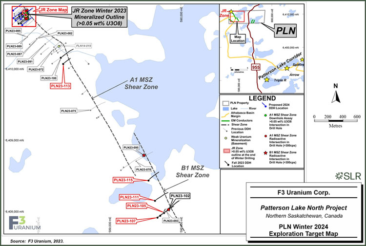
Based on the compilation of exploration work to date, F3 Uranium geologists have identified three high priority targets (Figure 1-1):
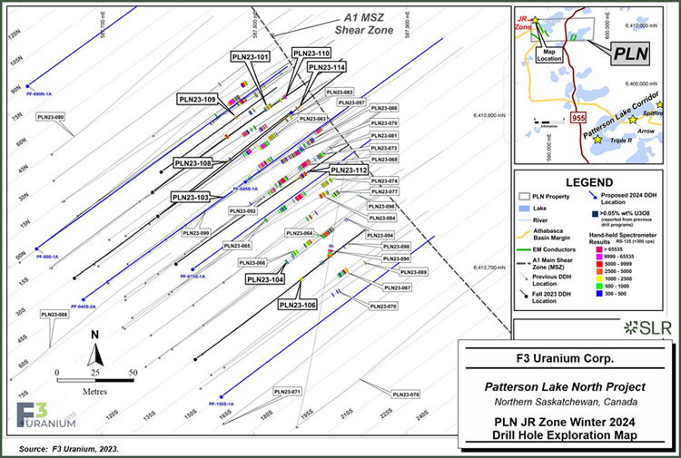
| 1 | JR Zone: Recent JR Zone drilling focused on defining the boundaries of mineralization but continued to yield high grade intercepts and future drilling at the zone will be aimed to further infill high-grade intercepts and continue to define the extent of mineralization, as well as to further understand the system and controls on mineralization that can be applied elsewhere on the property to develop exploration targets. Six holes that have been pre-cased in the fall of 2023 are located within and around the JR zone and will be extended in January 2024 in support of this work (Figure 1-2). |
| 2 | A1 conductor: The A1 conductor main shear zone, which hosts the JR zone, is a large structural zone and many areas along the structure remain untested. Parallel to A1, the newly defined B1 conductor has only been tested with a few holes. Targets are currently being planned on both A1 and B1 to better define and test the two large-scale conductors with hopes of discovering additional pods of mineralization or alteration zones that may lead to further target areas. Geochemistry results from the B1 area, as well as ground resistivity interpretations from the A1 and B1 areas are currently in progress which will drive exploration efforts aimed at discovering additional mineralized zones. Phase 1 of the Dias Geophysical (DIAS) 3D-DCIP ground resistivity survey is in progress, and currently focused over the B1 area. |
| 3 | B1 conductor: Recent drill hole intercepts at B1, including sandstone dissolution and silicification, as seen in PLN23-111, as well as multiple basement-hosted conductive structures related to the B1 shear system, will be used to create constrained 2D and 3D inversions to assist in the winter 2024 drill targeting. PLN23-111 was drilled approximately 200 m grid north of PLN23-093 where significant boron values were reported and cored a significant section of intensely brecciated, faulted and clay altered Athabasca Sandstone. Beneath this layer, the drill intersected the B1 shear zone, in basement rock characterized by strong graphitic and clay alteration. This is indicative of significant reactivated structures favorable for hosting uranium mineralization. In addition to strong silicification and dissolution in the overlying sandstone of the area, the B1 conductor corridor will be a priority drill target for future programs. |
Additional targets on the Property include radioactivity anomalies, strongly graphitic basement structures, and multiple untested EM conductors identified at the Broach and Minto properties, and these will be explored at a regional scale.
| 1-5 | |
| F3 Uranium Corp. | Patterson Lake North Project | January 25, 2023 |
| Report for NI 43-101 | SLR Project No.: 138.21599.00001 |
| Figure 1-1: | PLN Winter 2024 Exploration Target Map |
| 1-6 | |
| F3 Uranium Corp. | Patterson Lake North Project | January 25, 2023 |
| Report for NI 43-101 | SLR Project No.: 138.21599.00001 |
| Figure 1-2: | PLN JR Zone Winter 2024 Drill Hole Exploration Map |
| 1-7 | |
| F3 Uranium Corp. | Patterson Lake North Project | January 25, 2023 |
| Report for NI 43-101 | SLR Project No.: 138.21599.00001 |
| 2.0 | Introduction |
SLR International Corporation (SLR) was retained by F3 Uranium Corp. (F3 Uranium or the Company) for the completion of a NI 43-101 Technical Report (the Technical Report) on the Patterson Lake North (PLN) Project, located in northern Saskatchewan, Canada. The PLN Project comprises three properties: the PLN Property, which includes the JR Zone, the Minto Property (Minto), and the Broach Property (Broach), collectively, the Properties.
F3 Uranium (formerly Fission 3.0 Corp) was incorporated in October 2013 as a fully owned subsidiary of Fission Uranium Corp. (Fission Uranium). In November 2013, Fission 3.0 Corp. completed a plan of arrangement involving Alpha Mineral Inc. (Alpha) and Fission Uranium pursuant to which Fission Uranium acquired Alpha’s Minerals’ 50% interest in the Patterson Lake South (PLS) project. As a result of the transaction, certain properties and assets of Fission Uranium, including the PLN Project, became assets of F3 Uranium. F3 Uranium is no longer a wholly owned subsidiary of Fission Uranium.
The Company’s principal business activity is the acquisition and development of exploration and evaluation assets. To date, the Company has not generated revenues from operations and is considered to be in the exploration stage. F3 Uranium holds a 100% interest in the PLN Project located in the western Athabasca Basin in northern Saskatchewan. The Project consists of 40 mineral claims covering an area of 39,946 ha.
Exploration has been carried out on the PLN Property since 2005 by F3 Uranium and its predecessors. In 2013, GeoVector Management, Inc. completed a NI 43-101 Technical Report on the PLN Project in support of an application by Fission 3.0 Corp. for a listing on the Toronto Stock Exchange (TSX) Venture Exchange.
This Technical Report, which incorporate the results of drilling at the Project completed by F3 Uranium during 2022 and 2023, conforms to NI 43-101 Standards of Disclosure for Mineral Projects and supersedes the previous technical report.
| 2.1 | Sources of Information |
Sources of information and data contained in this Technical Report or used in its preparation are from publicly available sources in addition to confidential information owned by F3 Uranium including that of past property owners.
This Technical Report was prepared by Mark B. Mathisen, C.P.G., SLR Principal Geologist.
Mr. Mathisen visited the Property on August 29, 2023. Mr. Mathisen toured the operational areas and camp offices, inspected various parts of the Property, examined core from several drill holes, visited active drill sites and infrastructure, reviewed logging and sampling methods, and conducted discussions with F3 Uranium Project geologists on the current and future plans of operations. Mr. Mathisen is a Qualified Person (QP) in accordance with NI 43-101 and is responsible for all sections of this Technical Report.
During the preparation of this Technical Report, discussions were held with the following F3 Uranium personnel:
| ● | Sam Hartman, P.Geo., Vice President Exploration, F3 Uranium |
| ● | Erik Sehn, GIT, Project Manager, F3 Uranium |
| ● | Kodi Bowman, EPT, Environment, Health and Safety Officer, F3 Uranium |
| ● | Tony Gonzales, Senior Technical Consultant, F3 Uranium |
| 2-1 | |
| F3 Uranium Corp. | Patterson Lake North Project | January 25, 2023 |
| Report for NI 43-101 | SLR Project No.: 138.21599.00001 |
| ● | Reid Stanger, Geotechnical Analyst, F3 Uranium |
| ● | Victor Mitchell, Geotechnical Consultant GIS/Data Management/Research, F3 Uranium |
The documentation reviewed, and other sources of information, are listed at the end of this Technical Report in Section 27 References.
| 2-2 | |
| F3 Uranium Corp. | Patterson Lake North Project | January 25, 2023 |
| Report for NI 43-101 | SLR Project No.: 138.21599.00001 |
| 2.2 | List of Abbreviations |
Units of measurement used in this Technical Report conform to the metric system. All currency in this Technical Report is US dollars (US$) unless otherwise noted.
| μ | micron | kVA | kilovolt-amperes |
| μg | microgram | kW | kilowatt |
| a | annum | kWh | kilowatt-hour |
| A | ampere | L | litre |
| bbl | barrels | lb | pound |
| Btu | British thermal units | L/s | litres per second |
| °C | degree Celsius | m | metre |
| C$ | Canadian dollars | M | mega (million); molar |
| cal | calorie | m2 | square metre |
| cfm | cubic feet per minute | m3 | cubic metre |
| cm | centimetre | MASL | metres above sea level |
| cm2 | square centimetre | m3/h | cubic metres per hour |
| d | day | mi | mile |
| dia | diameter | min | minute |
| dmt | dry metric tonne | μm | micrometre |
| dwt | dead-weight ton | mm | millimetre |
| °F | degree Fahrenheit | mph | miles per hour |
| ft | foot | MVA | megavolt-amperes |
| ft2 | square foot | MW | megawatt |
| ft3 | cubic foot | MWh | megawatt-hour |
| ft/s | foot per second | oz | Troy ounce (31.1035g) |
| g | gram | oz/st, opt | ounce per short ton |
| G | giga (billion) | ppb | part per billion |
| Gal | Imperial gallon | ppm | part per million |
| g/L | gram per litre | psia | pound per square inch absolute |
| Gpm | Imperial gallons per minute | psig | pound per square inch gauge |
| g/t | gram per tonne | RL | relative elevation |
| gr/ft3 | grain per cubic foot | s | second |
| gr/m3 | grain per cubic metre | st | short ton |
| ha | hectare | stpa | short ton per year |
| hp | horsepower | stpd | short ton per day |
| hr | hour | t | metric tonne |
| Hz | hertz | tpa | metric tonne per year |
| in. | inch | tpd | metric tonne per day |
| in2 | square inch | US$ | United States dollar |
| J | joule | USg | United States gallon |
| k | kilo (thousand) | USgpm | US gallon per minute |
| kcal | kilocalorie | V | volt |
| kg | kilogram | W | watt |
| km | kilometre | wmt | wet metric tonne |
| km2 | square kilometre | wt% | weight percent |
| km/h | kilometre per hour | yd3 | cubic yard |
| kPa | kilopascal | yr | year |
| 2-3 | |
| F3 Uranium Corp. | Patterson Lake North Project | January 25, 2023 |
| Report for NI 43-101 | SLR Project No.: 138.21599.00001 |
| 3.0 | Reliance on Other Experts |
This Technical Report has been prepared by SLR for F3 Uranium. The information, conclusions, opinions, and estimates contained herein are based on:
| ● | Information available to SLR at the time of preparation of this Technical Report. |
| ● | Assumptions, conditions, and qualifications as set forth in this Technical Report. |
For the purpose of this Technical Report, SLR has relied on ownership information provided by F3 Uranium in the form of a series of Mineral Claim Disposition Abstracts from the Mineral Administration Registry of Saskatchewan (MARS) dated December 5, 2023. SLR has not researched property title or mineral rights for the PLN Property and expresses no opinion as to the ownership status of the property.
The SLR QP has taken all appropriate steps, in his professional opinion, to ensure that the above information from F3 Uranium is sound.
Except for the purposes legislated under provincial securities laws, any use of this Technical Report by any third party is at that party’s sole risk.
| 3-1 | |
| F3 Uranium Corp. | Patterson Lake North Project | January 25, 2023 |
| Report for NI 43-101 | SLR Project No.: 138.21599.00001 |
| 4.0 | Property Description and Location |
| 4.1 | Location |
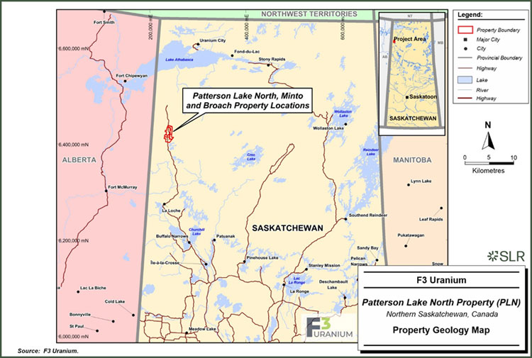
The PLN, Minto, and Broach properties are located in northern Saskatchewan, approximately 550 km north-northwest of the city of Prince Albert and 150 km north of the community of La Loche (Figure 4-1)
The PLN Property comprises two adjacent mineral claims in northern Saskatchewan, approximately 170 km northeast of Fort McMurray, Alberta, and 150 km north of La Loche, Saskatchewan (Figure 4-1). PLN is accessible by vehicle via the all-weather gravel Highway 955, which bisects the PLN Property from north to south.
The approximate centre of the PLN Property has the following coordinates:
| ● | Universal Transverse Mercator (UTM): 592,383 mE, 6,409,215 mN (NAD83 UTM Zone 12N) |
| ● | Geographic: 57°48′ 55.3″ N latitude and 109° 26′ 42″ W longitude |
The PLN Property lies within the 1:50,000 scale NTS map sheets 74F/14 (Murison Lake) and 74F/13 (Smart Lake). It has a roughly rectangular shape and spans approximately 11 km east- west and approximately four kilometres north-south. The approximate centre of the JR Zone has the UTM coordinates 587,826 mE, 6,410,763 mN (NAD83 UTM Zone 12N).
The Minto Property consists of 23 adjacent mineral claims in northern Saskatchewan, about 180 km northeast of Fort McMurray and 160 km north of La Loche (Figure 4-1). Minto is accessible by vehicle along the all-weather gravel Highway 955, which runs through the Minto Property from north to south.
The approximate centre of the Minto Property has the following coordinates:
| ● | UTM: 594,820 mE, 6,421,137 mN (NAD83 UTM Zone 12N) |
| ● | Geographic: 57°55′ 18.8″ N latitude and 109° 23′ 57.3″ W longitude |
The Minto Property is located within the 1:50,000 scale NTS map sheets 74F/13 (Smart Lake), 74F/14 (Murison Lake) and 74K/03 (James Creek). It has an irregular but roughly rectangular shape and extends approximately 14 km east-west at its widest and approximately 20 km north- south.
The Broach Property comprises 15 adjacent mineral claims in northern Saskatchewan, about 165 km northeast of Fort McMurray and 140 km north of La Loche (Figure 4-1). Broach is accessible by vehicle via the all-weather gravel Highway 955, which passes approximately two kilometres west of the Property’s centre from north to south.
The approximate centre of the Broach Property has the following coordinates:
| ● | UTM: 596,298 mE, 6,402,655 mN (NAD83 UTM Zone 12N) |
| ● | Geographic: 57° 45′ 20.3″ N latitude and 109° 23′ 54.3″ W longitude |
The Broach Property lies within the 1:50,000 scale NTS map sheets 74F/13 (Smart Lake), 74F/14 (Murison Lake) and 74F/11 (Forrest Lake). It has an irregular shape and at its widest extends for about 17 km east-west and for about 17 km north-south.
| 4-1 | |
| F3 Uranium Corp. | Patterson Lake North Project | January 25, 2023 |
| Report for NI 43-101 | SLR Project No.: 138.21599.00001 |
| Figure 4-1: | Location Map |
| 4-2 | |
| F3 Uranium Corp. | Patterson Lake North Project | January 25, 2023 |
| Report for NI 43-101 | SLR Project No.: 138.21599.00001 |
| 4.2 | Land Tenure |
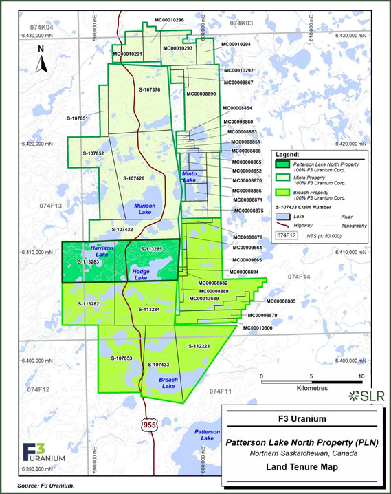
The PLN Property consists of two contiguous mineral claims covering an area of 4,074 ha (Figure 4-2). The JR Zone discovery is located on claim S-113283. Table 4-1 lists the relevant tenure information for the PLN Property.
| Table 4-1: | Land Tenure – Patterson Lake North |
| Claim | Effective Date |
Anniversary Date | Good
Standing Date |
Area (ha) |
Status |
| S-113283 | 2-Aug-2023 | 2-Aug-2024 | 31-Oct-2031 | 1,835 | Active |
| S-113285 | 2-Aug-2023 | 2-Aug-2024 | 31-Oct-2028 | 2,239 | Active |
Source: MARS Database (August 31, 2023)
The PLN Property and component claims are defined as electronic mineral claim parcels within the Mineral Administration Registry of Saskatchewan (MARS). As of the effective date of this Technical Report, the two mineral claims comprising the PLN Property are in good standing and are registered in the name of F3 Uranium Corp. As of August 31, 2023, assessment credits totaling $581,881 were available for claim renewal. Assessment credits totaling $101,850 are required to renew the Property claims upon their respective annual anniversary dates. In the absence of sufficient assessment credits, there is a provision in Saskatchewan to keep the claims in good standing by making a deficiency payment or a deficiency deposit.
The Minto Property consists of 23 mostly contiguous mineral claims covering an area of 19,864 ha (Figure 4-2). Table 4-2 lists the relevant tenure information for the Minto Property.
| Table 4-2: | Land Tenure – Minto Property |
| Claim | Effective Date |
Anniversary Date | Good
Standing Date |
Area (ha) |
Status |
| MC00008851 | 17-Oct-2017 | 17-Oct-2023 | 15-Jan-2027 | 66 | Active |
| MC00008852 | 17-Oct-2017 | 17-Oct-2023 | 15-Jan-2027 | 132 | Active |
| MC00008854 | 17-Oct-2017 | 17-Oct-2023 | 15-Jan-2027 | 50 | Active |
| MC00008860 | 17-Oct-2017 | 17-Oct-2023 | 15-Jan-2027 | 50 | Active |
| MC00008863 | 17-Oct-2017 | 17-Oct-2023 | 15-Jan-2027 | 66 | Active |
| MC00008865 | 17-Oct-2017 | 17-Oct-2023 | 15-Jan-2027 | 261 | Active |
| MC00008866 | 17-Oct-2017 | 17-Oct-2023 | 15-Jan-2027 | 86 | Active |
| MC00008867 | 17-Oct-2017 | 17-Oct-2023 | 15-Jan-2027 | 151 | Active |
| MC00008870 | 17-Oct-2017 | 17-Oct-2023 | 15-Jan-2027 | 279 | Active |
| MC00008871 | 17-Oct-2017 | 17-Oct-2023 | 15/Jan/2033 | 333 | Active |
| MC00008875 | 17-Oct-2017 | 17-Oct-2023 | 15/Jan/2033 | 394 | Active |
| MC00008886 | 17-Oct-2017 | 17-Oct-2023 | 15-Jan-2027 | 728 | Active |
| MC00008890 | 17-Oct-2017 | 17-Oct-2023 | 15-Jan-2027 | 2,423 | Active |
| MC00010291 | 11-Dec-2017 | 11-Dec-2023 | 11-Mar-2027 | 661 | Active |
| 4-3 | |
| F3 Uranium Corp. | Patterson Lake North Project | January 25, 2023 |
| Report for NI 43-101 | SLR Project No.: 138.21599.00001 |
| Claim | Effective Date |
Anniversary Date | Good
Standing Date |
Area (ha) |
Status |
| MC00010292 | 11-Dec-2017 | 11-Dec-2023 | 11-Mar-2027 | 132 | Active |
| MC00010293 | 11-Dec-2017 | 11-Dec-2023 | 11-Mar-2027 | 961 | Active |
| MC00010294 | 11-Dec-2017 | 11-Dec-2023 | 11-Mar-2027 | 398 | Active |
| MC00010296 | 11-Dec-2017 | 11-Dec-2023 | 11-Mar-2027 | 530 | Active |
| S-107376 | 21-Jul-2004 | 20-Jul-2024 | 18-Oct-2027 | 3,514 | Active |
| S-107426 | 21-Jul-2004 | 20-Jul-2024 | 18-Oct-2027 | 4,571 | Active |
| S-107432 | 29-Sep-2004 | 28-Sep-2023 | 27 Dec 2030 | 1,599 | Active |
| S-107851 | 26-Nov-2004 | 25-Nov-2023 | 23-Feb-2031 | 377 | Active |
| S-107852 | 26-Nov-2004 | 25-Nov-2023 | 23-Feb-2028 | 2,102 | Active |
Source: MARS Database (2023, August 31)
The Minto Property and component claims are defined as electronic mineral claim parcels within the Mineral Administration Registry of Saskatchewan (MARS). As of the effective date of this Technical Report, all 23 mineral claims comprising the Minto Property are in good standing and are all registered in the name of F3 Uranium Corp. As of August 31, 2023, assessment credits totaling $1,648,939 were available for claim renewal. Assessment credits totaling $419,596 are required to renew the Minto Property claims upon their respective annual anniversary dates. In the absence of sufficient assessment credits, there is a provision in Saskatchewan to keep the claims in good standing by making a deficiency payment or a deficiency deposit.
The Broach Property consists of 15 mostly contiguous mineral claims covering an area of 16,008 ha (Figure 4-2). Table 4-3 lists the relevant tenure information for the Broach Property.
| Table 4-3: | Land Tenure – Broach Property |
| Claim | Effective Date |
Anniversary Date | Good
Standing Date |
Area (ha) |
Status |
| MC00008878 | 17-Oct-2017 | 17-Oct-2023 | 15/Jan/2033 | 120 | Active |
| MC00008879 | 17-Oct-2017 | 17-Oct-2023 | 15/Jan/2033 | 556 | Active |
| MC00008882 | 17-Oct-2017 | 17-Oct-2023 | 15/Jan/2033 | 48 | Active |
| MC00008885 | 17-Oct-2017 | 17-Oct-2023 | 15/Jan/2032 | 279 | Active |
| MC00008889 | 17-Oct-2017 | 17-Oct-2023 | 15/Jan/2033 | 98 | Active |
| MC00008894 | 17-Oct-2017 | 17-Oct-2023 | 15/Jan/2033 | 16 | Active |
| MC00009664 | 15-Nov-2017 | 15-Nov-2023 | 13/Feb/2033 | 97 | Active |
| MC00009665 | 15-Nov-2017 | 15-Nov-2023 | 13/Feb/2033 | 65 | Active |
| MC00010300 | 11-Dec-2017 | 11-Dec-2023 | 11/Mar/2033 | 147 | Active |
| MC00013689 | 28-Feb-2020 | 28-Feb-2024 | 29/May/2031 | 3,409 | Active |
| S-107433 | 21-Jul-2004 | 20-Jul-2024 | 18/Oct/2031 | 2,253 | Active |
| S-107853 | 26-Nov-2004 | 25-Nov-2023 | 23/Feb/2032 | 2,608 | Active |
| 4-4 | |
| F3 Uranium Corp. | Patterson Lake North Project | January 25, 2023 |
| Report for NI 43-101 | SLR Project No.: 138.21599.00001 |
| Claim | Effective Date |
Anniversary Date | Good
Standing Date |
Area (ha) |
Status |
| S-112223 | 18-Jan-2012 | 17-Jan-2024 | 17/Apr/2031 | 2,092 | Active |
| S-113282 | 2-Aug-2023 | 2-Aug-2024 | 31/Oct/2031 | 1,923 | Active |
| S-113284 | 2-Aug-2023 | 2-Aug-2024 | 31/Oct/2028 | 2,295 | Active |
Source: MARS Database (2023, August 31)
The Broach Property and component claims are defined as electronic mineral claim parcels within the Mineral Administration Registry of Saskatchewan (MARS). As of the effective date of this Technical Report, all 15 mineral claims comprising the Broach Property are in good standing and are all registered in the name of F3 Uranium Corp. As of August 31, 2023, assessment credits totaling $2,518,957 were available for claim renewal. Assessment credits totaling $351,828 are required to renew the Property claims upon their respective annual anniversary dates. In the absence of sufficient assessment credits, there is a provision in Saskatchewan to keep the claims in good standing by making a deficiency payment or a deficiency deposit.
Any surface facilities and mine workings constructed would be located on Provincial lands. The right to use and occupy Provincial lands is acquired under a surface lease from the Province of Saskatchewan. A claim in good standing can be converted to a lease upon application and with the completion of a boundary survey. Leases are for a term of ten years and are renewable. A lease grants the holder the exclusive right to explore for, mine, recover, and dispose of any minerals within the lease lands. Annual expenditures of the lease for years 1 to 10 are C$25/ha, C$50/ha for years 11 to 20, and C$75/ha annually thereafter. A surface lease is for a maximum of thirty-three years.
To maintain the Property in good standing, exploration on the Property with annual expenditures of C$15/ha to C$25/ha is required.
| 4-5 | |
| F3 Uranium Corp. | Patterson Lake North Project | January 25, 2023 |
| Report for NI 43-101 | SLR Project No.: 138.21599.00001 |
| Figure 4-2: | Land Tenure |
| 4-6 | |
| F3 Uranium Corp. | Patterson Lake North Project | January 25, 2023 |
| Report for NI 43-101 | SLR Project No.: 138.21599.00001 |
| 4.3 | Required Permits |
Permits for timber removal, work authorization, temporary work camp permits, shore land alteration, and road construction are required for most exploration programs from the Saskatchewan Ministry of Environment and Saskatchewan Water Security Agency. Necessary permits are listed:
| ● | Surface Exploration Permit - general use permit, which lists all the rules and regulations to be followed. |
| ● | Forest product permit if trees are to be cut. |
| ● | Aquatic Habitat Protection Permit. |
| ● | Camp permit if there will be a camp on the Property. |
| ● | Term Water Rights License - water use permit(s) for camp use and drilling use |
If any exploration work crosses or includes work on water bodies, streams, and rivers, the Department of Fisheries and Oceans and the Coast Guard-Transport Canada must be notified. Ice/snow bridges and clear-span bridges do not require approval from the Coast Guard
There are no significant factors or risks known that may affect access, title, or the right or ability to perform work on the Property.
| 4.4 | Encumbrances |
SLR is not aware of any significant encumbrances to the Project including current and future permitting requirements and associated timelines, permit conditions, and violations and fines.
SLR is not aware of any environmental liabilities on the Property. F3 Uranium has all required permits to conduct the proposed work on the Properties. SLR is not aware of any other significant factors and risks that may affect access, title, or the right or ability to perform the proposed work program on the Property.
No obvious disturbance was noted during the site inspection, except for cut lines for geophysical work, drill pads, and drill roads.
| 4.5 | Royalties |
There are no royalties associated with the properties.
| 4-7 | |
| F3 Uranium Corp. | Patterson Lake North Project | January 25, 2023 |
| Report for NI 43-101 | SLR Project No.: 138.21599.00001 |
| 5.0 | Accessibility, Climate, Local Resources, Infrastructure and Physiography |
| 5.1 | Accessibility |
The PLN, Minto, and Broach properties are located approximately 165 km northeast of Fort McMurray, Alberta. The Properties can be accessed via air charter from Fort McMurray or by all-weather gravel road along Highway 955 (Cluff Lake Mine Road) about 160 km north of La Loche, Saskatchewan. Highway 955 bisects the Properties in a north-south direction. Two four- wheel drive roads branch off from Highway 955 allowing access to the east and west halves of the Properties.
La Loche is a remote community in the boreal forest region of northwestern Saskatchewan. It has a population of 2,514 people and offers some basic services such as temporary accommodations, fuel, and emergency medical services (Statistics Canada, 2021).
The nearest major city to La Loche is Fort McMurray, Alberta, which has an urban population of approximately 76,000 people and offers a greater range of services and facilities (Wood Buffalo Municipal Census, 2021). Fort McMurray also has an international airport that can accommodate fixed-wing aircraft and helicopters for charter.
The driving distance between Fort McMurray and La Loche varies depending on the season. During the winter, when the ice roads are open, the fastest route is via AB-881 and SK-956. During the summer, when the ice roads are closed, the access route is via Highway 155, which is considerably slower than in the winter.
La Loche can also be accessed from Saskatoon, the largest city in Saskatchewan with a population of about 266,141 people (Statistics Canada, 2021). Saskatoon has an international airport that can accommodate fixed-wing aircraft and helicopters for charter. The driving distance between Saskatoon and La Loche is approximately 600 km via routes SK-155 and SK-55. La Loche can also be accessed from Saskatoon by air. There are several charter companies that operate flights between the two locations.
| 5.2 | Climate |
The PLN Project is located within the mid-boreal upland ecoregion, located approximately 125 km south-southeast of Lake Athabasca in Saskatchewan, situated within the Boreal Shield Ecozone (Smith et al., 1998).
The climate in this ecoregion exhibits distinctive seasonal variations, characterized by extended cold winters and comparatively brief, warmer summers. Summers typically span from June to August, offering a relatively short period of warm weather. Winters, on the other hand, extend from November to March, constituting a lengthy cold season (Padbury et al., 1998).
Snow cover significantly influences this region’s climate. It blankets the landscape for an extensive period, lasting six to seven months from November to April. This prolonged snow cover profoundly shapes the ecosystem and environmental processes within the ecoregion (Marshall and Schutt, 1999).
The climate of the mid-boreal upland ecoregion aligns with a boreal or subarctic ecoclimate classification. This classification is characterized by extended, cold winters and comparatively brief, warmer summers. The environmental dynamics associated with this classification play a crucial role in defining the region’s unique ecological characteristics (Marshall and Schutt, 1999).
| 5-1 | |
| F3 Uranium Corp. | Patterson Lake North Project | January 25, 2023 |
| Report for NI 43-101 | SLR Project No.: 138.21599.00001 |
The three closest Environment Canada weather stations’ climatic data are included in Table 5-1.
| Table 5-1: | Climatic Data – Cluff Lake, Fort Chipewyan, and Fort MacKay |
| Cluff
Lake, SK 58° 22′ N 109° 31′ W |
Fort
Chipewyan, AB 58° 46′ N 111° 07′ W |
Fort
Mackay, AB 56° 58′ N 111° 27′ W | |
| Mean January Temperature | -20.4°C | -21.9°C | -21.0°C |
| Mean July Temperature | 16.9°C | 17.0°C | 17.0°C |
| Extreme Maximum Temperature | 36.0°C | 34.7°C | 37.0°C |
| Extreme Minimum Temperature | -49.0°C | -50.0°C | -50.6°C |
| Annual Precipitation | 451.0 mm | 365.7 mm | 414.0 mm |
| Annual Rainfall | 319.3 mm | 250.4 mm | 302.3 mm |
| Annual Snowfall | 162.8 cm | 116.9 cm | 133.8 cm |
Source: Ghaffari et al., 2023
| 5.3 | Local Resources |
Various services are available at La Loche, Saskatchewan, including temporary accommodations, fuel, and emergency medical services. A greater range of services is available at Fort McMurray, Alberta. Fixed-wing aircraft are available for charter at Fort McMurray, and Buffalo Narrows, La Loche, and La Ronge, Saskatchewan. Helicopters are available for charter at Fort McMurray and La Ronge.
| 5.4 | Infrastructure |
With the exception of the all-weather, gravel road Highway 955, there is no permanent infrastructure at the Properties. Field operations are currently conducted from the Big Bear Camp located approximately five kilometres southwest of the Properties. The Property has sufficient space for an open pit or underground mining operation including space for waste rock piles and tailings facilities. Water is readily available. A surface lease would be required from the Provincial government in advance of construction of permanent surface facilities on the Property.
| 5.5 | Physiography |
The topography of northern Saskatchewan is characterized by low hills, ridges, drumlins, and eskers, with lakes and muskeg common in the low-lying areas. Outcrop of the underlying Athabasca sandstone and basement rocks is rare. Numerous lakes and ponds generally show a northeasterly elongation imparted by the most recent glaciation. The elevation in the area varies between approximately 500 metres above sea level (MASL) and 565 MASL.
| 5-2 | |
| F3 Uranium Corp. | Patterson Lake North Project | January 25, 2023 |
| Report for NI 43-101 | SLR Project No.: 138.21599.00001 |
The soils in this region are predominantly loamy and grey, leading to the growth of relatively taller trees compared to the nearby Shield region. Common tree species found in this area include aspen, white spruce, jack pine, black spruce, and tamarack.
The diverse wildlife in this region includes moose, woodland caribou, mule deer, white-tailed deer, elk, black bear, timber wolf, and beaver. The avian population encompasses species such as the white-throated sparrow, American redstart, bufflehead, ovenbird, and hermit thrush.
Furthermore, the aquatic ecosystem is rich and includes fish species such as northern pike, pickerel, whitefish, lake trout, rainbow trout, and perch.
| 5-3 | |
| F3 Uranium Corp. | Patterson Lake North Project | January 25, 2023 |
| Report for NI 43-101 | SLR Project No.: 138.21599.00001 |
| 6.0 | History |
| 6.1 | Prior Ownership |
F3 Uranium (formerly Fission 3.0 Corp) was incorporated in October 2013 as a fully owned subsidiary of Fission Uranium Corp. (Fission Uranium). In November 2013, Fission 3.0 Corp. completed a plan of arrangement involving Alpha Mineral Inc. (Alpha) and Fission Uranium pursuant to which Fission Uranium acquired Alpha’s 50% interest in the Patterson Lake South (PLS) project. As a result of the transaction, certain properties and assets of Fission Uranium, including the PLN Project, became assets of Fission 3.0 Corp, now F3 Uranium. F3 Uranium is no longer a wholly owned subsidiary of Fission Uranium. A summary of ownership is presented in Table 6-1.
| 6-1 | |
| F3 Uranium Corp. | Patterson Lake North Project | January 25, 2023 |
| Report for NI 43-101 | SLR Project No.: 138.21599.00001 |
| Table 6-1: | Summary of Ownership |
| Date Range |
Company / Companies |
Historic Property |
Property
(PLN, Broach, Minto) |
Ownership Details |
Comments |
| 1969 | Wainoco Oil & Chemicals Ltd. | Permit 1 | Broach | 100% | 77,700 hectares |
| 1969 | Bow Valley Land Co. Ltd. | Permit 2 | All | 100% | |
| 1968-1969 | A. R. Babchuk / Taneloy Mines Ltd. | Permit 2 | Minto | unknown | 77,700 hectares / option agreement for Taneloy Mines Ltd. to earn-in |
| 1974 | Uranerz Exploration and Mining Ltd. | Disposition #2, Disposition #3 |
Broach | unknown | Each disposition 51,800 hectares |
| 1976-1982 | Saskatchewan Mining & Development Corp. / Imperial Oil Ltd. | Permit 16 - Derkson Project | All | 50% SMDC / 50% Imperial Oil joint venture |
52,836 hectares |
| 1976-1982 | Saskatchewan Mining & Development Corp. / Hudson Bay Exploration Development Company Ltd. | Permit 16 - Harrison Project | All | 50% SMDC / 50% HBED joint venture
|
24,864 hectares |
| 1977-1981 | Imperial Oil Ltd. / Saskatchewan Mining & Development Corp. | Permit 2 | Minto | 66.67% Imperial Oil / 33.33% SMDC joint venture | 74,120 hectares / Permit was transferred to Esso Canada Ltd. - date unknown |
| 1976-1981 | Canadian Occidental Petroleum Ltd. | CLU Property (CBS 4745, 4746, 4747, 4748, 4749, 4750, 4816, 4817) |
Broach | 100% | 33,710 hectares |
| 1988-1998 | Cogema Resources Inc. (Amok Ltd.) / Power Reactor and Nuclear Fuel Development Corp. | Beatty River Project (7 claims) | Minto | Transferred Cogema to Amok 1989. Amok 50% / PNC 50% joint venture | 7 claims = 20,400 hectares / converted from Permits MPP 1162, 1163 |
| 2006-2009 | Titan Uranium Inc. | Castle South Project (10 claims) | Minto | 100% | 10 claims = 33,000 hectares / carried interest 10%, NSR 2% |
| 6-2 | |
| F3 Uranium Corp. | Patterson Lake North Project | January 25, 2023 |
| Report for NI 43-101 | SLR Project No.: 138.21599.00001 |
| Date Range |
Company / Companies | Historic Property | Property |
Ownership Details | Comments |
| 2004-2008 | ESO Uranium Inc. | Hook Lake Project | Broach & Minto | 100% | 10 claims = 52,716 hectares |
| 2004-2007 | Strathmore Minerals Corp. | Patterson Lake Property | All | 100% | 9 claims = 25,316 hectares |
| 2007-2013 | Fission Energy Corp. | Patterson Lake Property | All | 100% | 9 claims = 25,316 hectares; 1 claim = 2,092 hectares added Jan 2012 |
| 2013-2013 | Fssion Uranium Corp. | Patterson Lake Property | All | 100% / 50% earn-in agreement with Azincourt Resources Inc. | 10 claims = 27,408 hectares |
| 2013-2017 | Fission 3.0 Corp. | Patterson Lake Property | All | 100% / 50% earn-in agreement with Azincourt Resources Inc. | 10 claims = 27,408 hectares |
| 2017-2019 | Fission 3.0 Corp. | Patterson Lake Property | All | 100% / 50% earn-in agreement with Azincourt Resources Inc. | 37 claims = 39,946 hectares (27 claims = 9,129 hectares added Oct-Dec 2017) |
| 2019-2023 | Fission 3.0 Corp. | Patterson Lake Property | All | 100% | 37 claims = 39,946 hectares / Azincourt Resources Inc. agreement terminated Mar 29, 2019 |
| 2023 | F3 Uranium Corp. | Patterson Lake Property | All | 100% | 37 claims = 39,946 hectares (corporate name change Jan 31, 2023) |
| 2023 | F3 Uranium Corp. | PLN, Broach, Minto Properties | All | 100% | Three-way property split. PLN 2 claims = 4,074 hectares. Broach 15 claims = 16,008 hectares. Minto 23 claims = 19,864 hectares |
| 6-3 | |
| F3 Uranium Corp. | Patterson Lake North Project | January 25, 2023 |
| Report for NI 43-101 | SLR Project No.: 138.21599.00001 |
| 6.2 | Exploration and Development History |
This section includes a summary of historical exploration programs in the vicinity of the Properties. The programs covered areas that intersected the current Property claims. A high level summary of historical exploration programs in the vicinity of the Properties is presented in Table 6-2.
| 6.2.1 | Wainoco Oil and Chemicals Ltd. (1969) |
In 1969, Wainoco Oil and Chemicals Ltd. conducted uranium exploration in the PLN property area. They employed an airborne magnetic and radiometric survey to detect magnetic and radioactive anomalies indicative of uranium mineralization. Additionally, they performed an air photo mosaic analysis to map drainage areas and lineaments, aiming to identify potential uranium deposits; however, the exploration did not yield evidence of uranium mineralization at depth.
| 6.2.2 | Bow Valley Land Co. Ltd. (1969) |
Bow Valley Land Co. Ltd. conducted uranium exploration in the PLN property area in 1969. Their methods included an airborne magnetic and radiometric survey, aiming to detect anomalies indicative of uranium. They also used photogeologic mapping to analyze surface geology and the extent of Athabasca Basin sediments. Ground inspection of prospective airborne radiometric anomalies was another method employed; however, they did not find evidence of uranium mineralization at depth.
| 6.2.3 | Taneloy Mines Ltd. (1969) |
Taneloy Mines Ltd. engaged in uranium exploration in the PLN property area in 1969. Their methods encompassed an airborne radiometry survey to detect elevated radioactivity areas, hydro-geochemical sampling to analyze water samples for uranium and other elements, and geological ground reconnaissance and mapping to identify bedrock geology. Despite these efforts, no evidence of uranium mineralization at depth was found.
| 6.2.4 | Uranerz Exploration and Mining Ltd. (1974) |
Uranerz Exploration and Mining Ltd. conducted uranium exploration in the PLN property area in 1974. Their methods included radiometric prospecting and mapping, with a focus on identifying anomalies associated with potential uranium deposits. They also carried out a lake sediment sampling program to assay samples for uranium and other elements. Despite these efforts, they did not discover significant uranium anomalies.
| 6.2.5 | Saskatchewan Mining & Development Corp. (1976–1980) |
Saskatchewan Mining & Development Corp. (SMDC) conducted a comprehensive uranium exploration program in the PLN property area from 1976 to 1980. They utilized various methods, including an airborne INPUT electromagnetic (EM) survey to identify conductive anomalies, lake sediment sampling to assay for uranium and other elements, boulder and scintillometer prospecting, and ground very-low-frequency (VLF)-EM and time domain EM (TDEM) surveys to investigate conductive swarms. The exploration did not result in evidence of uranium mineralization at depth.
| 6-4 | |
| F3 Uranium Corp. | Patterson Lake North Project | January 25, 2023 |
| Report for NI 43-101 | SLR Project No.: 138.21599.00001 |
| 6.2.6 | Imperial Oil Ltd. (1977) |
In 1977, Imperial Oil Ltd. conducted exploration in the Montgomery Lake area, focusing on copper and uranium. Their methods involved lake sampling to analyze sediments and water for copper and uranium, soil sampling and radiometric prospecting, airborne and ground surveys to study the geology. Despite their efforts, they did not find evidence of copper or uranium mineralization at depth.
| 6.2.7 | Canadian Occidental Petroleum Ltd. (CANOXY) (1977) |
CANOXY investigated uranium mineralization potential in the Patterson Lake area in 1977. They employed an airborne INPUT EM survey to determine the depth and structure of the crystalline basement. Additionally, surface sampling, including alphameter and scintillometer measurements, was conducted. However, the results did not indicate uranium mineralization at depth.
| 6.2.8 | Canadian Occidental Petroleum Ltd. (CANOXY) (1978–1979) |
In 1978 and 1979, CANOXY continued their uranium exploration efforts. They executed a diamond drilling program specifically in the south part of the PLN property at Sholte and Broach lakes. The focus was on testing the shoulders of aeromagnetic highs and interpreted structural lineaments. The diamond drilling, which totaled 2,880 m in 21 vertical holes, revealed basement rocks divided into Western granites and Eastern metamorphics. However, uranium analyses were low at less than 1.0 ppm in all holes, and no evidence of uranium mineralization at depth was found.
| 6.2.9 | Cogema Resources Inc. (Amok Ltd.) (1990–1998) |
Between 1990 and 1998, Cogema Resources Inc. (COGEMA) initiated a comprehensive exploration campaign. Their objective was to identify typical Athabasca Basin unconformity-style uranium mineralization associated with basement electromagnetic conductors indicating graphitic shear zones within pelitic metasedimentary rock units. They employed methods including airborne GEOTEM EM surveys, ground UTEM-III surveys, and diamond drilling. The diamond drilling was concentrated on conductive trends to the west of the PLN property. Despite these efforts, definitive evidence of uranium mineralization at depth was not established.
| 6.2.10 | Cogema Resources Inc. (COGEMA) (2004–2005) |
In 2004 to 2005, COGEMA conducted airborne geophysics surveys on their West Athabasca project in collaboration with UEX Corp. The primary aim was to detect graphitic conductors at or near the basement, associated with potential uranium mineralization. They employed the BHP-Billiton FALCON gravity system, including magnetics and radiometrics. These surveys covered a substantial area north of the PLN property. However, the results did not yield definitive evidence of uranium mineralization at depth.
| 6.2.11 | Titan Uranium Inc. (TITAN) (2005–2006) |
In 2005, TITAN acquired a large land position in the West Athabasca. The land position was split up into several different projects, of which the Castle South block covered the far north section of the PLN property. TITAN commenced a program of extensive airborne MEGATEM electromagnetic and magnetic surveys, contracted to Fugro Airborne Surveys Ltd. (Fugro). The Castle South Extension survey (as Fugro named it) was flown across the Castle South block. Fugro’s interpretation of the Castle South block revealed sharply contrasting strike directions in magnetic features, interpreted as right-lateral strike slip faults. The Total Energy Envelope product of the electromagnetic field correlated in some respects to magnetic lows that are thought to represent felsic lithologies in the crystalline basement. The depth of Athabasca sediments in this area hindered interpretation of the data. In April-May 2009, TITAN commissioned Patterson Geophysics Inc. to perform Pole-Pole Resistivity on four lines that covered parts of the northernmost claims at PLN. The purpose was to locate and characterize weak conductive trends interpreted from data of a MEGATEM® airborne survey and to test magnetic lineaments that are interpreted to correspond to the location of the Beatty River fault system. Zones of low apparent resistivity interpreted to have conductive basement lithology associations were detected and were consistent with the early time MEGATEM Bz08 channel data, and two of the lines displayed resistivity anomalies characteristic of an alteration chimney extending from the basement up into the overlying sandstone.
| 6-5 | |
| F3 Uranium Corp. | Patterson Lake North Project | January 25, 2023 |
| Report for NI 43-101 | SLR Project No.: 138.21599.00001 |
| 6.2.12 | ESO Uranium Corp. (2005–2007) |
ESO Uranium Corp. (ESO) conducted exploration in the Hook Lake property between 2005 and 2006. The airborne MEGATEM electromagnetic and magnetic survey was designed to detect bedrock conductors associated with uranium mineralization. The survey indicated bedrock conductors occurring parallel to the north and south shores of Broach Lake. Additionally, ESO collected sandstone boulder samples for geochemical analysis, aiming to detect alteration and geochemical metal anomalies indicative of Athabasca Basin-type uranium deposits within sandstone float and outcrop. Although anomalies were detected, no clearly defined geochemical boulder train anomalies were identified, and definitive evidence of uranium mineralization at depth was not established (source: AF 74F-0016). During Feb-Mar 2007, ESO commissioned a fixed loop time-domain electromagnetic survey on the Broach Lake part of their Hook Lake claim block. The survey’s purpose was to further delineate electromagnetic conductors identified by the earlier MEGATEM airborne survey. A total of 6.5 km of TEM data was collected and indicated a shallow conductive feature dipping shallowly to the southeast.
| 6.2.13 | Purepoint Uranium Group Inc. (PUREPOINT) (2007–2008) |
During 2007 and 2008, PUREPOINT performed ground geophysical surveying on the West and Central grids of their Hook Lake project, on the southeast side of the PLN property. The 2007 ground geophysics consisted of gradient array IP/Resistivity and pole-dipole array IP/Resistivity surveys, a very small portion of which overlapped the PLN property on the southeast side of Broach Lake. The induced polarization (IP) resistivity sections were examined for Low Apparent Resistivity Chimneys (LARCs) that may represent alteration halos within sandstone overlying conductors. The 2008 ground geophysics consisted of a stepwise moving loop TEM survey carried out by Quantec Geoscience Ltd. between February 18 and March 24, 2008. A very small portion of the survey overlapped onto the southeast corner of the PLN property in the vicinity of the southeast shore of Broach Lake.
| 6.2.14 | Strathmore Minerals Corp. (2004–2006) |
Between July and November 2004, Strathmore Minerals Corp. acquired nine mineral claims totaling 25,316 ha in the Patterson Lake area. During fall 2005 and spring 2006, Aeroquest Ltd. and Fugro Airborne Surveys were contracted to conduct airborne geophysical surveys over the Patterson Lake Property. The intent of the surveys was to map conductive horizons at depth near the sub-Athabasca unconformity. The Aeroquest heli-supported AeroTEM survey covered the entire property at 300 m line-spacing for a total of 970 line-km. Based on the response from the Aeroquest survey, the Fugro MEGATEM survey covered the north claims with a total of 298 line-km.
Ground HLEM (maxmin) and Induced Polarization-Resistivity surveys targeted the results of the airborne geophysics and were carried out by Peter E. Walcott and Associates Ltd. in the spring of 2006. Three grids were established over the Grygar Lake, Hodge Lake, and A4-A1 conductor and magnetic/lithology targets, for a total of 25 km of HLEM and IP-DC Resistivity (DCRES) surveying.
| 6-6 | |
| F3 Uranium Corp. | Patterson Lake North Project | January 25, 2023 |
| Report for NI 43-101 | SLR Project No.: 138.21599.00001 |
| 6.2.15 | Fission Energy Corp. (2006–2012) |
In 2006, Fission Energy Corp. (FEC) absorbed the Canadian assets of Strathmore Minerals Corp., including the nine claims of the Patterson Lake Property.
Work by FEC in 2006 and 2007 included radon cup surveys and diamond drilling. The radon cup surveys were carried out by Alpha-Track Uranium Exploration Services in June and July 2007 over airborne geophysical targets, on a grid on the west side of Hodge Lake and three grids in the northern claim area. Radon cups were buried at 100 m intervals and a total of 1,893 cups were retrieved. In general, background values were very low, reflecting the deep sandstone cover in the area. In October 2007, RadonEX Ltd. was contracted to complete an Electret Ion Chamber (EIC) radon detection survey in the southern portion of the property. In total, 275 stations were recorded on a single grid. The purpose of the survey was to follow up anomalous results from the June 2007 Alpha-Track radon cup survey. The results were confirmed by the EIC survey and further orientation surveys were recommended.
In November and December 2007, Fugro conducted a MEGATEM electromagnetic and magnetic survey over the south half of the Patterson Lake Property. This survey was intended to continue coverage from the Strathmore MEGATEM survey that covered the north half of the property in 2006. In total, 749 line-km of data were collected.
Between February and April 2008, Peak Drilling Ltd. was contracted to complete nine diamond drill holes for a total of 2,795.22 m drilled on the west side of Hodge Lake and the southwest side of Harrison Lake.
In August 2012, Special Projects Inc. was commissioned to perform a high resolution airborne magnetic survey over the south part of the Patterson Lake Property. The purpose was to map geological lithologies and structure. A flight line direction of 90 degrees azimuth and 50 m line spacings were used resulting in 6,574.8 line-km of data collection.
A crew of six personnel headed by Dr. Paul Ramaekers collected B-horizon soil samples between August 9 and 22, 2012. An additional set of representative samples were taken along the Cluff Lake Road that traverses the property from south to north. A factor analysis of the 310 soil samples indicated areas anomalous in unconformity uranium indicators in areas that included a known conductive zone beneath Hodge Lake, a mineralized esker system below Broach Lake, and a weaker set of anomalies north of Hodge Lake in the ‘Conductor E’ area.
Between September and December 2012 IP-DCRES and Small Moving Loop Time Domain Electromagnetic (TDEM) surveys were carried out by Discovery International Geophysics Inc. and Patterson Geophysics Ltd., respectively. The DCRES survey comprised 30 km of data collection on grid B, while the TDEM survey totaled 69 km of SQUID (Super-conducting Quantum Interfering Devices) data collection on grids B, C, and G4. The resistivity analysis on grid B indicated a typical alteration ‘chimney’ on the west conductor, at the intersection of two interpreted structural features. The TDEM analysis indicated a very good quality conductor (A1) on grid G4, a bowl-shaped conductive feature on the grid B, and a very poor-quality conductor on grid C.
| 6-7 | |
| F3 Uranium Corp. | Patterson Lake North Project | January 25, 2023 |
| Report for NI 43-101 | SLR Project No.: 138.21599.00001 |
| 6.2.16 | Fission Uranium Corp. (Fission Uranium) (2012–2013) |
In April 2013, Fission Uranium, a wholly owned subsidiary of Fission Energy Corp. (FEC), completed a plan of arrangement whereby Fission Uranium obtained certain assets of FEC including the Patterson Lake Property. The Patterson Lake Property was renamed the Patterson Lake North Property (PLN). In April 2013, Fission Uranium and Azincourt Resources Inc. (Azincourt) entered into a four-year property option agreement whereby Azincourt could earn up to a 50% interest in the PLN property, with Fission Uranium as property operator.
During August 2013, Aeroquest Airborne carried out a helicopter-borne versatile time domain electromagnetic (VTEM max) geophysical survey over the north portion of the Patterson Lake North Property. A total of 303 line-kilometers of geophysical data were acquired during the survey. Flight lines were oriented in an east-west direction and spaced at 400 m apart. The survey was successful in identifying the A4, Block A, U, and N conductor trends.
In October 2013 an Internal Field Gradient test survey was conducted by EMPulse Geophysics Ltd. in the Minto Lake area. Fifty-one stations at 100 m spacing were doubly collected on a single survey line for 5.0 line-km of coverage. Three clear gradient anomalies at stations 15, 18, and 20 were evident with a possible fourth anomaly at station 26. It appeared that the gradient anomaly at station 15 was due to a deep basement conductor while the anomalies at stations 18, 20, and 26 were structural, possibly due to faults.
| 6.2.17 | Fission 3.0 Corp. (2013-2018) |
The PLN Property became part of the Fission 3.0 Corp. (Fission 3.0) portfolio as a result of the Fission Uranium/Alpha Minerals agreement in December 2013. Fission 3.0 continued as operator of the property option agreement with Azincourt Resources Inc.
During December 2013 through to March 2014 Discovery Int’l Geophysics Inc. carried out high temperature (HT) SQUID and coil moving-loop TEM surveys over the A4 Extension, Broach Lake, and Regional Sideline grids. A total of 59.8 km of slingram moving-loop transient EM data were collected over 15 profile lines distributed among the three survey grids. The Broach Lake survey identified three weak to moderate conductors, the Regional Grid results indicated a wide complex conductor system, and the A4 Extension survey showed relatively high conductivities with shallow dips to the west.
During April to August 2014, Patterson Geophysics Inc. conducted DC resistivity surveys. In total the surveys comprised 34.0 km of pole-dipole in the Broach Lake grid area and 61.2 km of indirect pole-pole in the North Grid area. Two significant resistivity low anomalies were identified in the Broach Lake area, and also two significant resistivity anomalies in the lower sandstone bench at the North Grid.
From January to March 2014 RadonEX Ltd. conducted electret ionization chamber (EIC) radon in lake water and radon in lake sediment surveys over select geophysical targets located in the southern parts of Harrison and Hodge Lakes. At Harrison Lake, initial results were encouraging and a total of 100 radon-in-water and 10 radon-in-sediment samples were collected. At Hodge Lake a total of 120 radon-in-water and 12 radon-in-sediment samples were collected, with inconclusive results.
| 6-8 | |
| F3 Uranium Corp. | Patterson Lake North Project | January 25, 2023 |
| Report for NI 43-101 | SLR Project No.: 138.21599.00001 |
| Table 6-2: | Summary of Exploration History at PLN Conducted by F3 and its Predecessors |
Year |
Assessment
File |
Company | F3 Uranium Property |
Area |
Type
of Exploration Work |
Work Performed |
Contractor |
Comments |
1969
|
74F11-0002
|
Wainoco Oil & Chemicals Ltd. |
Broach
|
south area of PLN | Airborne magnetics and radiometrics |
2,032 line-km
|
Geo-X Surveys
|
To detect magnetic and radioactive anomalies that could indicate uranium mineralization |
|
1969
|
74F11-0002
|
Wainoco Oil & Chemicals Ltd. |
Broach
|
south area of PLN | Airphoto mosaic analysis | To delineate drainage and muskeg areas, map lineaments, and map surficial features | ||
| 1969 | 74F11-0001 | Bow Valley Land Co. Ltd. | All | south half of PLN | Airborne magnetics and radiometrics | Geo-X Surveys | To detect magnetic and radioactive anomalies that could indicate uranium mineralization | |
| 1969 | 74F11-0001 | Bow Valley Land Co. Ltd. | All | south half of PLN | Photogeologic mapping | To map the surface geology and extent of the Athabasca Basin sediments | ||
| 1969 | 74F11-0001 | Bow Valley Land Co. Ltd. | PLN and Broach | south half of PLN | Ground inspection | Ground follow-up of prospective airborne radiometric anomalies | ||
| 1969 | 74F14-0001 | Taneloy Mines Ltd. | Minto | northeast section of PLN | Airborne radiometrics | 1,050 line-km | To detect areas of elevated radioactivity that could indicate uranium mineralization | |
| 1969 | 74F14-0001 | Taneloy Mines Ltd. | Minto | northeast section of PLN | Lake water sampling | 266 lake water samples | To detect elevated uranium, copper, lead and zinc in lake water | |
| 1969 | 74F14-0001 | Taneloy Mines Ltd. | Minto | northeast section of PLN | Geological mapping | To identify the bedrock geology and the extent of the Athabasca Basin sediments | ||
| 1974 | 74F-0001, 74F-0005, 74F-0006 |
Uranerz Exploration & Mining Ltd. |
Broach | southmost section of PLN | Heli-supported radiometric prospecting |
To detect areas of elevated radioactivity that could indicate uranium mineralization | ||
1974
|
74F-0001, 74F-0005, 74F-0006 |
Uranerz Exploration & Mining Ltd. |
Broach
|
southmost section of PLN | Lake sediment sampling | To detect elevated uranium, copper, lead and zinc in lake sediments | ||
| 1977 | 74F14-0005 | Imperial Oil Ltd. | Minto | northmost section of PLN | Airborne radiometrics | 154 line-km | Trigg-Woollett Associates | |
| 1977 | 74F14-0005 | Imperial Oil Ltd. | Minto | northmost section of PLN | Lake water and sediment sampling | 429 lake water samples / 391 lake sediment samples | Trigg-Woollett Associates | To detect elevated uranium and copper in lake water and sediments |
1978
|
74F14-0006
|
Imperial Oil Ltd.
|
Minto
|
northmost section of PLN | Soil sampling and radiometric prospecting |
82 soil samples
|
Trigg-Woollett Associates |
To detect elevated uranium in soils |
| 1978 | 74F14-0006 | Imperial Oil Ltd. | Minto | northmost section of PLN | Ground gravity | 58 km long profile | Trigg-Woollett Associates | |
| 1979-1981 | 74F14-0008, 74F14-0010 |
Imperial Oil Ltd. | Minto | northmost section of PLN | Diamond drilling | 3 DDH for 1,416.8 m total | DW Coates Enterprises Ltd. | Drill targets on flexures in regional gravity profile |
| 1977 | 74F11-0010 | Canadian Occidental Petroleum Ltd. |
Broach | southmost section of PLN | Airborne INPUT EM and magnetics | 1,144 line-km | Fugro Airborne Surveys Ltd. | To detect electromagnetic conductors and map magnetic signatures |
1977
|
74F11-0011 |
Canadian Occidental Petroleum Ltd. |
Broach
|
southmost section of PLN | Geochemical sampling | 660 soil samples, 14 bog samples, 23 lake sediment samples |
To detect elevated uranium in soil, bog, and lake sediments |
| 6-9 | |
| F3 Uranium Corp. | Patterson Lake North Project | January 25, 2023 |
| Report for NI 43-101 | SLR Project No.: 138.21599.00001 |
Year |
Assessment
File |
Company | F3 Uranium Property |
Area |
Type
of Exploration Work |
Work Performed |
Contractor |
Comments |
|
1978-1979
|
74F11-0012, 74F11-0013 |
Canadian Occidental Petroleum Ltd. |
Broach
|
southmost section of PLN |
Diamond drilling |
4 DDH for 757.7 m total |
Connors Drilling Ltd. / Canadian Longyear Ltd. | Tested the shoulders of magnetic highs and interpreted structural lineaments |
| 1977-1982 | 74F14-0003, 74F14-0012, 74F13-0037 |
Saskatchewan Mining & Development Corp. |
All | south half of PLN | Airborne INPUT EM and magnetics | 2,153 line-km | Fugro Airborne Surveys Ltd. | To detect electromagnetic conductors and map magnetic signatures |
1979
|
74F13-0032 |
Saskatchewan Mining & Development Corp. | PLN and Minto | west-central PLN (Eastley Lake-Murison Lake) |
Overburden sampling and lake sediment sampling |
149 samples / 72 samples |
Follow up to previous sampling work | |
| 1977 | 74F14-0004 | Saskatchewan Mining & Development Corp. | All | south half of PLN | Lake sediment sampling | 185 lake sediment samples | To detect elevated uranium, copper, nickel, and zinc in lake sediments | |
| 1980 | 74F14-0013 | Saskatchewan Mining & Development Corp. |
Minto | west-central PLN (Eastley Lake) |
Airborne EM-30 | 250 line-km | Hudson Bay Exploration & Development Ltd. |
Follow up to inconclusive INPUT results |
|
1980
|
74F14-0011 |
Saskatchewan Mining & Development Corp. |
All
|
south half of PLN | Boulder prospecting | To identify boulders with elevated radioactivity | ||
1981
|
74F14-0014 |
Saskatchewan Mining & Development Corp. |
PLN
|
west side PLN (Eastley Lake) |
Ground DEEPEM |
14 line-km DEEPEM |
Crone Geophysics Ltd. | Ground definition of airborne electromagnetic conductors |
| 1990 | 74-0010 | Cogema Resources Inc. | Minto | northwest and north-central PLN |
Airborne GeoTEM | Geoterrex Ltd. | To identify the occurrence and characteristics of conductive and magnetic units in the area. | |
| 1995-1998 | 74F14-0021, 74F14-0022 |
Cogema Resources Inc. | Minto | west-central PLN | Ground UTEM-III electromagnetic | Lamontange Geophysics Ltd. | Ground definition of airborne electromagnetic conductors | |
| 2004-2005 | 74K-0019 | Cogema Resources Inc. | Minto | north section of PLN | Airborne MEGATEM | 7,161 line-km | Fugro Airborne Surveys Ltd. | |
2004-2005
|
74K-0020
|
Cogema Resources Inc. |
Minto
|
north section of PLN | FALCON airborne gravity, magnetics, radiometrics |
6,679 line-km
|
BHP-Billiton Ltd. / Sander Geophysics | |
| 2005 | 74F-0015 | Titan Uranium Inc. | Minto | north section of PLN | Airborne MEGATEM | 1,955 line-km | Fugro Airborne Surveys Ltd. | |
| 2005 (Oct) | Strathmore Minerals Corp. | All | Property-wide | Airborne AeroTEM | 970 line-km | Aeroquest Ltd. | to map conductive horizons at depth near the sub-Athabasca unconformity | |
2005-2006
|
74F-0016
|
ESO Uranium Corp.
|
Broach and Minto
|
east section of PLN
|
Sandstone boulder sampling
|
264 samples
|
To test for presence of alteration and geochemical metal anomalies associated with Athabasca Basin type uranium deposits within Athabasca Formation sandstone float and outcrop | |
2006
|
74F-0016
|
ESO Uranium Corp.
|
Broach and Minto
|
east section of PLN
|
Airborne MEGATEM
|
2,169 line-km
|
Fugro Airborne Surveys Ltd.
|
To try and detect graphitic conductors at or near the basement, known to be between 400 and 500 metres below surface from previous drilling, that could be associated with uranium mineralization. |
| 6-10 | |
| F3 Uranium Corp. | Patterson Lake North Project | January 25, 2023 |
| Report for NI 43-101 | SLR Project No.: 138.21599.00001 |
Year |
Assessment
File |
Company | F3 Uranium Property |
Area |
Type
of Exploration Work |
Work Performed |
Contractor |
Comments |
2006 (May)
|
Strathmore Minerals Corp. | Minto | North claims | Airborne MEGATEM | 298 line-km | Fugro Airborne Surveys Ltd. | follow up to results of AeroTEM survey | |
2006 (Apr-Jun)
|
Strathmore Minerals Corp.
|
All
|
Grids 2,3,4 (Hodge, Grygar, A4-A1 Grid)
|
ground HLEM / IP-DCRES / Grid Establishment |
25 line-km / 37 line-km
|
Patterson Geophysics
|
Investigate airborne EM conductors located by Aeroquest surveys | |
2006 (Oct-Nov)
|
Fission Energy Corp. | Broach | South shore of Hodge Lake | Diamond Drilling | One drill hole, Total 306.9 m drilled | Target Drilling Inc. | Hole lost in unconsolidated sand, did not reach unconformity | |
2007 (Jan-Apr)
|
Fission Energy Corp.
|
PLN and Broach
|
South shore Hodge Lake, southwest shore Harrison Lake |
Diamond Drilling
|
Four drill holes, Total 1,100 m drilled.
|
Canadian Mine Services Inc.
|
Hodge Lake hole lost in unconsolidated sand | |
2007 (Jun-Jul)
|
Fission Energy Corp. |
All
|
West side Hodge Lake, northern claims |
Radon cup survey
|
1,893 radon cups over four grids | Alpha-Track Uranium Exploration Services |
Follow up to airborne geophysical targets | |
2007 (Oct)
|
Fission Energy Corp. | PLN | West side of Hodge Lake | EIC ground radon detection survey | 275 points on one grid | RadonEX Ltd. | follow-up of anomalous area found by earlier radon-cup survey (Smith and Dahrouge, 2007) | |
2007 (Nov-Dec)
|
Fission Energy Corp. | All | South half of property | MegaTEM Airborne Electromagnetics/ Magnetics |
749 line-km | Fugro Airborne Surveys | delineate broad conductive zones that may correspond to sub-Athabasca unconformity | |
2007-2008
|
74F11-0037, 74F11-0039
|
Purepoint Uranium Group Inc.
|
Broach
|
southeast section of PLN
|
ground IP-Resistivity survey / stepwise moving loop TEM |
127 line-km / 108.5 line-km
|
R.J. Meikle & Associates / Quantec Geoscience Ltd. | To select target areas within extensive conductor systems indicated by previous VTEM surveys |
2008 (Feb-Apr)
|
Fission Energy Corp. | All | Harrison and Hodge Lake areas |
Diamond Drilling | 2,795 m in nine holes, only six holes reached target depth |
Peak Drilling Ltd. | target anomalous radon survey results and electromagnetic conductors from Megatem survey | |
2012 (Aug)
|
Fission Energy Corp
|
All
|
~70% of Property; did not survey north ~30% |
SPI Detailed Airborne Magnetics/Radiom etrics
|
6,574.8 line-km (4,893 line-km within PLN boundaries) |
Special Projects Inc.
|
determine lithological contacts & structural setting from magnetic data interpretation? | |
2012 (Aug) |
Fission Energy Corp | All | Property-wide | Soil sampling B-Horizon | Six prospectors / 310 soil samples | Fission Energy Corp. (Ramaekers) | Soil sampling over previously identified EM conductors, attempt to prioritize conductors | |
2012 (Sep-Oct)
|
Fission Energy Corp | PLN and Broach | Hodge B-Grid | Ground DC Resistivity | 12.5 line-km pole-dipole / 17.5 line-km pole-pole
|
Discovery Int’l Geophysics | Attempt to define low resistivity alteration zones associated with electromagnetic conductors | |
2012 (Oct-Dec) |
Fission Energy Corp |
All
|
Grid G4 (A1 conductor), Grid B, Line C |
Moving Loop TDEM / Grid Establishment |
69.0 line-km / 67.5 line-km |
Patterson Geophysics / Big Bear Contracting Ltd. |
Ground definition of airborne electromagnetic conductors | |
2013 (Aug) |
Fission Uranium Corp |
Minto |
North half of property | VTEM MAX Airborne Electromagnetics |
303.1 line-km |
Aeroquest Airborne |
delineate conductive zones |
| 6-11 | |
| F3 Uranium Corp. | Patterson Lake North Project | January 25, 2023 |
| Report for NI 43-101 | SLR Project No.: 138.21599.00001 |
Year |
Assessment
File |
Company | F3 Uranium Property |
Area |
Type
of Exploration Work |
Work Performed |
Contractor |
Comments |
2013 (Oct)
|
Fission Uranium Corp | Minto | Regional N-Grid | MT (magneto-tellurics) Survey | Five line-km (1.6 km of which on Zadar Property) | EMPULSE Geophysics Ltd
|
a test magneto-tellurics survey | |
2013 (Nov)
|
Fission Uranium Corp |
PLN
|
Southwest shore Harrison Lake | Reverse Circulation Drilling |
50.3 m drilled (PLN-003)
|
Northspan exploration Ltd. | Unsuccessful test to drill through overburden in order to set casing ahead of diamond drilling | |
2013-2014 (Dec-Jan)
|
Fission 3.0/Azincourt | PLN and Broach | A4 Extension Grid | MLTEM / Grid Establishment | 11.7 line-km / 9.5 line-km | Discovery Int’l Geophysics / Big Bear Contracting Ltd. | Ground definition of airborne electromagnetic conductors | |
2014 (Feb-Mar)
|
Fission 3.0/Azincourt | Broach | Broach Lake Grid | MLTEM / Grid Establishment | 31.5 line-km / 26.7 line-km | Discovery Int’l Geophysics / Big Bear Contracting Ltd. |
Ground definition of airborne electromagnetic conductors | |
2014 (Mar)
|
Fission 3.0/Azincourt |
Minto
|
ML40 Regional Grid
|
MLTEM / Grid Establishment |
16.6 line-km / 24.8 line-km
|
Discovery Int’l Geophysics / Big Bear Contracting Ltd. |
Ground definition of airborne electromagnetic conductors | |
2014 (May-Aug)
|
Fission 3.0/Azincourt |
Minto
|
Regional N-Grid | DC Resistivity pole-dipole_pole / Grid Establishment |
61.2 line-km / 83 line-km
|
Patterson Geophysics / Big Bear Contracting Ltd.
|
Attempt to define low resisitivity alteration zones associated with electromagnetic conductors | |
2014 (Apr-May)
|
Fission 3.0/Azincourt | Broach | Broach Lake Grid | DC Resistivity pole-dipole / Grid Establishment
|
34.0 line-km / 26.5 line-km | Patterson Geophysics / Big Bear Contracting Ltd.
|
Attempt to define low resisitivity alteration zones associated with electromagnetic conductors
| |
2014 (Jan)
|
Fission 3.0/Azincourt |
PLN
|
Hodge Lake B-Grid |
Radon Sampling
|
120 RIW Samples, 12 RIS samples |
RadonEx
|
Attempt to define anomalous radon signatures over geophysical and structural targets | |
2014 (Jan-Mar)
|
Fission 3.0/Azincourt |
PLN
|
Harrison Lake G4-Grid |
Radon Sampling
|
100 RIW samples, 10 RIS samples |
RadonEx
|
Attempt to define anomalous radon signatures over geophysical and structural targets | |
2014 (Jan-Feb)
|
Fission 3.0/Azincourt
|
PLN
|
G4 Grid - A1, B1 and A3 conductors |
Diamond Drilling (Winter)
|
Nine drill holes planned, five holes completed, one lost in overburden, three cancelled, Total 1,937 m drilled |
Bryson Drilling/Northspan Exploration |
Drilling on prospective A1 and A3 conductors
| |
2014 (Jun-Jul)
|
Fission 3.0/Azincourt | PLN | G4 Grid - A1 and A4 conductors | Diamond Drilling (Summer) | Six diamond drill holes completed. Total 2,130.2 m drilled. | Bryson Drilling | Drilling on prospective A1 and A4 conductors | |
2014 (Nov)
|
Fission 3.0/Azincourt | PLN | G4 Grid: PLN14-020 | Borehole EM | 335 m Z (axial) component | Patterson Geophysics | To check for presence of off-hole conductor |
| 6-12 | |
| F3 Uranium Corp. | Patterson Lake North Project | January 25, 2023 |
| Report for NI 43-101 | SLR Project No.: 138.21599.00001 |
| 6.3 | Historical Resource/Reserve Estimates |
There is no historical resource or reserve estimates for uranium mineralization on the Property.
| 6.4 | Past Production |
No production has occurred on the Property.
| 6-13 | |
| F3 Uranium Corp. | Patterson Lake North Project | January 25, 2023 |
| Report for NI 43-101 | SLR Project No.: 138.21599.00001 |
| 7.0 | Geological Setting and Mineralization |
| 7.1 | Regional Geology |
The Athabasca Basin is a large, Paleoproterozoic-aged sedimentary basin covering much of northern Saskatchewan and part of northern Alberta (Jefferson et al., 2007). At surface, the basin is an oval shape and covers an approximate dimension of 450 km by 200 km and covers over 85,000 km2 (Figure 7-1).
The basins geology is dominated by two lithological elements: (i) Polydeformed metamorphic basement rocks of Archean and Proterozoic age, which is overlain unconformably by (ii) 100 m - 1000 m of flat lying to gently dipping, post-metamorphic quartz sandstone of the late Proterozoic Athabasca group.
| 7-1 | |
| F3 Uranium Corp. | Patterson Lake North Project | January 25, 2023 |
| Report for NI 43-101 | SLR Project No.: 138.21599.00001 |
| Figure 7-1: | Geological Sketch Map of the Athabasca Basin |
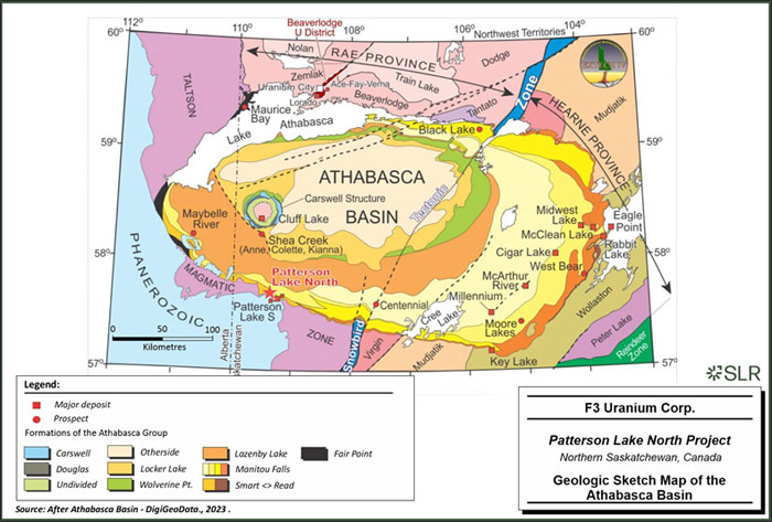
| 7-2 | |
| F3 Uranium Corp. | Patterson Lake North Project | January 25, 2023 |
| Report for NI 43-101 | SLR Project No.: 138.21599.00001 |
| 7.1.1 | Crystalline Basement |
The crystalline basement underlying the basin consists of three major lithotectonic zones. The Talston magmatic zone (TMZ), the Rae Province and the Hearne Province form the basement assemblage. The TMZ underlies the far western side of the basin with the Rae underlying the center and the Hearne underlying the east. The Rae province consists mostly of metasedimentary supracrustal sequences as well as granitoid rocks. The Hearne province consists of primarily granitic gneiss. The TMZ is characterized by a variety of plutonic rocks within an older basement complex (McNicoll et al., 2000). These rocks vary widely in composition from amphibolites to granitic gneiss to high-grade pelitic gneiss.
The Rae and Hearne provinces are separated by the large-scale northeast-southwest Snowbird Tectonic Zone. The Snowbird Tectonic Zone is locally referred to as the Virgin River shear zone at the south end of the basin and the Black Lake fault at the north. Other major fault zones include the Grease River shear zone, Black Bay fault, Cable Bay shear zone and Tabbernor-type (regional north-south trending) fault zones.
Prior to the deposition of the Athabasca group sediments, the metamorphic rocks of the Rae, Hearne and TMZ experienced a period of erosion, weathering, and non-deposition. The top of the crystalline basement tends to show intense weathering (MacDonald, 1980): a thin, bleached zone at the unconformity is followed by a hematite-stained unit of weathered metamorphic rocks slowly changing into a green zone where mafic minerals have been altered to chlorite. The zone of intense chloritization slowly dissipates with depth. This sequence can commonly be distinguished in drill core on the PLN property.
| 7.1.2 | Athabasca Group |
The Athabasca group is interpreted to have been filled over 200 Ma during four major depositional sequences which coalesced into a single basin (Ramaekers et al., 2007). The sediments within the basin are dominated by unmetamorphosed, siliciclastic, conglomeratic sandstones. The basin is relatively flat lying with a gentle dip towards the center of the basin and a steeper dip in the northern, southern and western portions. The maximum depth established by drilling was 1,500 m with most of the basin thought to be 100 m -1000 m in depth. Much of the sediment within the basin shows a variable range of hematite alteration.
The five regional sequences of fluviatile sands and gravels filled five subbasins within the Athabasca basin from different directions. Sequence 1 is the Fair Point Formation. Sequence 2 begins with the sandy Smart Formation in the west and is overlain by the Manitou Falls Formation. Sequence 3 includes Lazenby Lake and Wolverine Point Formations. Sequence 4 comprises of the Locker Lake, Otherside, Douglas and Carswell Formations (Ramaekers et al., 2007).
| 7.1.3 | Quaternary Geology |
The thickness of Quaternary Sediments is highly variable around the Athabasca basin ranging from 0 m at Key Lake to over 100 m at Patterson Lake North. Bedrock is rarely exposed within the basin with quaternary material covering almost the entire land surface. Drumlins, Eskers and other glacial landforms dominate the landscape. These features generally show a north-easternly orientation.
| 7-3 | |
| F3 Uranium Corp. | Patterson Lake North Project | January 25, 2023 |
| Report for NI 43-101 | SLR Project No.: 138.21599.00001 |
| 7.2 | Local Geology |
The Projects are located within two domains: Clearwater and Lloyd. The Clearwater Domain divides the Lloyd Domain, which was previously known as the Western Granulite and the Firebag domains. The divisions of the Lloyd Domain are situated to the east and west of the Clearwater Domain, respectively. The Clearwater Domain is not well defined due to limited surface exposure and defined mainly by an aeromagnetic high superimposed over the Lloyd Domain. Drilling suggests the domain consists primarily of equigranular granite, porphyritic granite, and felsic to intermediate gneiss. This domain represents a mobile zone with middle amphibolite facies metamorphic conditions, where Hudson age tectonic and metamorphic events are probable (Lewry & Sibbald, 1980). This domain provides good source rocks for uranium and are believed to be intrusive in origin (Figure 7-2).
The Lloyd Domain to the west of the Clearwater Domain consists primarily of Proterozoic age (Card et. al. 2007) series of granulite facies metamorphic grade granodioritic, granitic, gabbroic, and layered and blue quartz bearing gneisses. Smaller amounts of anorthosite, quartzite and pelitc gneiss have been interpreted.
The Lloyd Domain lying to the east of the Clearwater Domain is older than the Clearwater and consists of an assemblage of cataclysmically deformed and retrogressively metamorphosed gneisses and granulite facies described in three major groups: granitic and granodioritic gneiss; quartz-sericite, chlorite gneiss; and garnetiferous pyroxene granulites.
| 7-4 | |
| F3 Uranium Corp. | Patterson Lake North Project | January 25, 2023 |
| Report for NI 43-101 | SLR Project No.: 138.21599.00001 |
| Figure 7-2: | Local Geology Map |
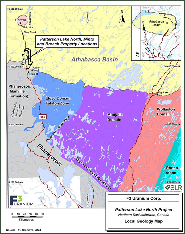
| 7-5 | |
| F3 Uranium Corp. | Patterson Lake North Project | January 25, 2023 |
| Report for NI 43-101 | SLR Project No.: 138.21599.00001 |
| 7.3 | Property Geology |
The PLN, Minto and Broach properties are located along the southwestern edge of the Athabasca basin. The PLN and Broach properties lie across the Athabasca basin boundary. Minto is contained fully within the basin and lies 1.8 km from the basin boundary at its closest point. The properties lie mainly within the Lloyd Domain, but the Clearwater Domain may intersect the eastern portion of the Broach property. At PLN, the mineralization discovered in the JR zone is in a large graphite-rich fault zone within orthogneisses of the Lloyd domain.
All claims are covered by the Athabasca Group sandstones lying unconformably on crystalline basement. The Minto property is fully within the basin whereas the PLN and Broach properties lie along the basin boundary. The Smart Lake, Manitou Falls and Lazenby Lake Formations of the Athabasca Group cover much of the PLN, Broach and Minto properties. The formations range in thickness from 0 m at the basin boundary along the southern end of the PLN and Broach claims to greater than 650 m in the northern portions of the Minto property (Figure 7-3).
| 7.3.1 | Smart Lake Formation |
The Smart Lake formation is a uniform, fine to coarse quartz arenite with horizontal bedding and sparce isolated pebbles increasing in abundance in the down hole direction. This formation is thought to lie unconformably on the crystalline basement in the northern portions of the Minto Property
| 7.3.2 | Manitou Falls Formation |
The Manitou Falls Formation is the most widespread sandstone unit located across the properties. In many areas, especially within the PLN and Broach properties, this geological unit lies unconformably on the crystalline basement. The Manitou Falls Formation also lies unconformably on the Smart Lake Formation where Smart Lake is present. The Manitou Falls Formation consists of sandstones and pebbly sandstone and occasionally, thin well laminated fine sand to mudstone beds. Most of the sandstone intersected in drilling on the properties is interpreted to be from the Manitou Falls Formation.
| 7.3.3 | Lazenby Lake Formation |
When present, the Lazenby Lake Formation sits unconformably above the Manitou Falls Formation and is characterized by a moderately sorted, fine-coarse pebbly sandstone with a thin basal conglomerate (Ramaekers et al., 2007). Although this formation is interpreted to lie over parts of the PLN, Minto and Broach properties it has been difficult to distinguish in drill core.
| 7.3.4 | Quaternary Geology |
Quaternary overburden covers all the properties. Drilling indicates overburden depths range from approximately seven metres in the center of the Minto property to over 100 m in the southern sections of the PLN and Broach Lake properties. Overburden has been reworked by glaciation leaving drumlins, eskers, and moraines on the properties. Overburden consists mainly of arenite with larger boulders and till.
| 7-6 | |
| F3 Uranium Corp. | Patterson Lake North Project | January 25, 2023 |
| Report for NI 43-101 | SLR Project No.: 138.21599.00001 |
| Figure 7-3: | Property Geology Map |
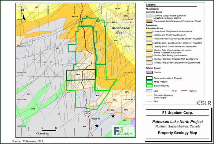
| 7-7 | |
| F3 Uranium Corp. | Patterson Lake North Project | January 25, 2023 |
| Report for NI 43-101 | SLR Project No.: 138.21599.00001 |
| 7.4 | Mineralization |
Appreciable high-grade mineralization is known to occur on the PLN Property in a zone which has been named the JR zone. Currently, the JR zone has been defined by 52 drill holes.
Uranium mineralization of the JR zone is hosted within metamorphosed basement lithologies within a large-scale, deep-rooted fault-system referred to as the A1 conductor Main shear zone (MSZ) that dips toward the southwest. The A1 EM conductor, located at the western edge of the PLN property, extends for roughly 2.65 km, and trends NW-SE. The geological analogue of the EM conductor is termed the A1 main shear zone; it is a reverse fault system comprised primarily of brittle and ductile deformed graphitic-and sulfide-rich gneisses and granitoids. Mineralization has been intersected along a strike extent of approximately 165 m between grid line 030N to 135S. The widest mineralized interval to date was observed in hole PLN23-068 with 18.0 m (230.5 m to 248.5 m), averaging 8.8% U3O8 including 4.5 m (235.0 m to 239.5 m) averaging 30.1% U3O8 ( Figure 7-4). Shallow drilling angles allow for nearly perpendicular testing of the A1 shear zone. The upper extent of the mineralized zone is approximately 200 m vertically below surface, beneath approximately 120 m of till overburden and 60 m of Athabasca sandstone.
The location of mineralization within the main shear zone is variable; although generally hosted near the footwall side of the deformation zone, this is not always the case and varies along strike. Within high grade mineralization, alteration is intense and often replaces or overprints the primary mineralogy of the host rock with only a weakly defined remnant texture remaining. Around and within the main shear zone at JR the dominant alteration styles are bleaching, clay, chlorite, and abundant fine-grained sericite Brick-red hematite is primarily observed within the hanging wall above the main shear zone, but discrete sections of hematite alteration can are observed within the shear zone occasionally along with lesser common limonite. Graphite and sulfides are still observed locally either separately or together, usually near lower grade areas of the JR zone.
The basement shear zone hosted mineralization on the PLN Property occurs in a variety of styles including fine-grained disseminated veins, nodular or blebs, as well as massive to semi-massive high-grade pitchblende. The high-grade sections are often associated with strong clay alteration and in some cases extreme bleaching displaying a “wormy” texture with a strong contrast between the jet-black pitchblende and bone white colored clays. High-grade semi-massive sections have been recorded with up to 4.5 m wide at PLN23-068 (235.0 m to 239.5 m) averaging 30.1% U3O8. Grades with massive and semi-massive sections are also very strong and highlighted at PLN22-035 with 1.0 m (263.0 m to 264.0 m) averaging 59.2% U3O8. At the time of this technical report, no mineralization has been intersected within the overlying Athabasca Sandstone or at the Athabasca unconformity, although basement mineralization is near the Unconformity. Mineralization has been observed as close as eight metres to the unconformity in hole PLN23-068. The Athabasca sandstone above the JR zone is heavily altered and often very fractured or unconsolidated and poor recovery is common. The sandstone commonly displays dark brown sulfide staining, strong silicification, dissolution and clay alteration. Based on portable infrared mineral analyzer (PIMA) analysis the dominant clay species above the JR zone is primarily Kaolinite. Approaching the unconformity, strong boron anomalies are commonly observed.
| 7-8 | |
| F3 Uranium Corp. | Patterson Lake North Project | January 25, 2023 |
| Report for NI 43-101 | SLR Project No.: 138.21599.00001 |
| Figure 7-4: | PLN Cross Section |
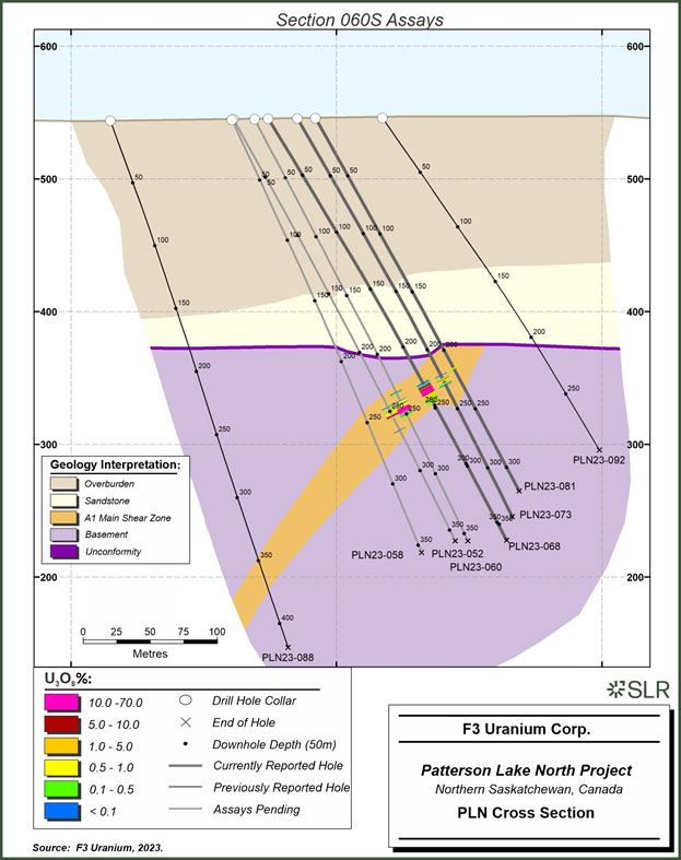
| 7-9 | |
| F3 Uranium Corp. | Patterson Lake North Project | January 25, 2023 |
| Report for NI 43-101 | SLR Project No.: 138.21599.00001 |
| 8.0 | Deposit Types |
The JR Zone is an example of a basement-hosted, structurally controlled uranium prospect. It was discovered by F3 Uranium during the fall 2022 drilling program on the PLN Property. It was associated with off-scale radioactivity (>65,535 cps) within the A1 main shear zone and is associated with massive pitchblende mineralization. Since the initial discovery, follow-up drilling has expanded the JR Zone along strike and up-dip toward the Athabasca unconformity. This indicates a close association of the JR Zone with the Athabasca Group unconformity. The geological setting encountered during drilling showed structural complexity like that of the primary conductor at Fission Uranium’s PLS project which is interpreted as a basement-hosted, structurally controlled, high-grade Athabasca unconformity-type uranium deposit (Bingham and Leqault, 2018).
The unconformity between the Athabasca Group sediments and the underlying basement rocks is a favorable setting for uranium deposits. The JR zone is a mineralized zone that occurs within the basement rocks, close to the unconformity. Drill planning continues to test the basement hosted uranium mineralization but also aims to explore the potential for uranium enrichment at or above the unconformity in the overlying sandstone layer.
Uranium deposits have been identified in various regions of Saskatchewan and Alberta, specifically at, above, and beneath the unconformity of the Athabasca Group. The uranium mineralization can be found deep within the basement or elevated up to 100 m in the sandstone (Zenghua et al., 2017). At Fission Uranium’s PLS property located to the southeast of PLN, Minto, and Broach properties, uranium has been detected in minor quantities in the overlying Devonian sediments and discovered in the basement at depths ranging from immediately at or just below the unconformity to 400 m beneath it (Ghaffari et al., 2023). Uranium typically manifests as uraninite/pitchblende, forming veins and semi-massive to massive replacement bodies. Most often, mineralization is spatially linked with steeply inclined, graphitic basement structures that have extended into the sandstones and displaced the unconformity during successive reactivation events. These structures are believed to represent significant fluid pathways as well as chemical/structural traps for mineralization over geological time. The reactivation events likely introduced additional uranium into mineralized zones and facilitated remobilization (Johnstone et al., 2021).
Uranium deposits associated with unconformities are typically found in the form of pods, veins, and semi-massive replacements, primarily composed of pitchblende, near the basal unconformities, particularly those between Proterozoic conglomeratic sandstone basins and metamorphosed basement rocks (Jefferson et al., 2007). These prospective basins in Canada are filled with thin, relatively flat-lying, and pervasively altered Proterozoic conglomerate, sandstone, and mudstone (Jefferson et al., 2007). The basement gneiss was intensely weathered and deeply eroded, with variably preserved thicknesses of reddened, clay-altered, hematitic regolith grading down through a green chloritic zone into fresh rock. The basement rocks typically comprise highly metamorphosed interleaved Archean to Paleoproterozoic granitoid and supracrustal gneiss including graphitic metapelite that hosts many of the uranium deposits. The U-Pb isochron ages on pitchblende range from 1,600 Ma to 1,350 Ma. Mines consist of various proportions of two styles of mineralization: monometallic pitchblende that fills veins, breccia fillings, and replacements in fault zones; and polymetallic replacement pitchblende that forms lenses just above or straddling the unconformity.
Reactivated basement faults and two distinct hydrothermal fluids characterize the Athabasca unconformity-type uranium deposit model. These faults, which are typically rooted in basement graphitic gneiss, exhibit brittle reactivation that extends upward through the overlying sandstones, providing a conduit for the mineralizing system. One of the essential fluids is reducing in nature, originating from the basement and channeled along basement faults (Alexandre et al., 2005).
| 8-1 | |
| F3 Uranium Corp. | Patterson Lake North Project | January 25, 2023 |
| Report for NI 43-101 | SLR Project No.: 138.21599.00001 |
Two primary types of deposits have been identified within this model: sandstone-hosted egress-type and basement-hosted ingress-type (Quirt, 2003). The former, exemplified by Midwest A, involves the mixing of oxidized sandstone brine with relatively reduced fluids emanating from the basement into the sandstone. The latter, represented by deposits like Triple R and Rabbit Lake, are formed by fluid-rock reactions between oxidizing sandstone brine entering basement fault zones and the wall rock. Both types of mineralization occur at sites where a spatially stable redox gradient/front is present due to the interaction of basement-sandstone fluid.
While these deposits can be high-grade, with uranium concentrations ranging from a few percent to 20% U3O8, they are not physically extensive. They typically span 100 m to 150 m in length and a few metres to 30 m in width and/or thickness (Jefferson et al., 2007). Egress-type deposits are often polymetallic (U-Ni-Co-Cu-As) and generally trace the path of the underlying graphitic gneisses and associated faults along the unconformity (Jefferson et al., 2007). In contrast, ingress-type deposits, which are essentially monomineralic uranium deposits, can exhibit more irregular geometry (Jefferson et al., 2007).
Uranium deposits of the unconformity-type are characterized by extensive alteration halos. These halos are relatively confined in the basement but expand significantly as they ascend into the Athabasca Group, extending tens to over a hundred metres above the unconformity. The presence of hydrothermal alteration is indicated by various markers such as chloritization, tourmalinization (indicated by high boron and dravite), multiple instances of hematization, illitization, silicification/de-silicification, and dolomitization (Jefferson et al., 2007; Hoeve, 1984; Hoeve and Quirt, 1987).
Figure 8-1 illustrates various models for unconformity-type uranium deposits of the Athabasca Basin.
| 8-2 | |
| F3 Uranium Corp. | Patterson Lake North Project | January 25, 2023 |
| Report for NI 43-101 | SLR Project No.: 138.21599.00001 |
| Figure 8-1: | Illustrations of Various Models for Unconformity Type Deposits of the Athabasca Basin |
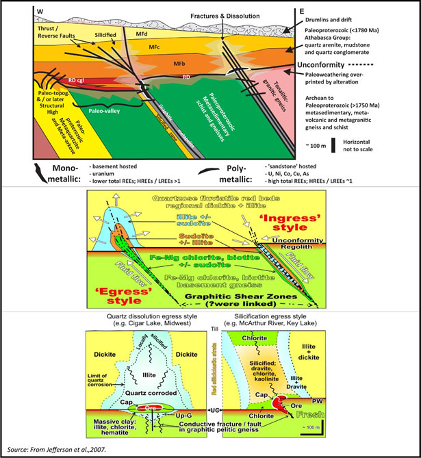
| 8-3 | |
| F3 Uranium Corp. | Patterson Lake North Project | January 25, 2023 |
| Report for NI 43-101 | SLR Project No.: 138.21599.00001 |
| 9.0 | Exploration |
In August 2018, a MobileMT airborne geophysical survey was conducted by Expert Geophysics as a test in the area of the ‘N’ VTEM conductor northwest of Minto Lake. The single test line was flown for nine kilometres in a northeast direction.
During December 2021 to January 2022, a Small Moving Loop Electromagnetic Survey (MLTEM) and a Pole-Dipole DC Resistivity Survey (DCRES) were carried out in the Broach Lake area by Discovery International Geophysics Inc. to define drill targets on the ground. A total of 12.9 km of MLTEM and 16.0 km of DCRES data was collected. Modeling and inversion of the datasets provided drill target locations.
During May to June 2022, further MLTEM and DCRES surveys were carried out by Discovery International Geophysics Inc., in the area of the A1 conductor (G4 grid) southwest of Harrison Lake. A total of 4.9 km of MLTEM and 13.95 km of DCRES data was collected. Modeling and inversion of the datasets provided drill target locations.
In June 2023 Rekon Solutions Inc. was contracted to complete a drone-supported Lidar survey to obtain high resolution elevation data covering an area of 983.8 ha in the A1 conductor (G4 grid) area.
In August 2023, Expert Geophysics Ltd. was commissioned to complete a helicopter borne MobileMT electromagnetic and magnetic survey over the A1 and PLN survey blocks. The purpose was to map bedrock structure and lithology including possible alteration and mineralization zones. A total of 2,281 line-km was flown within two blocks.
Table 9-1 lists the exploration programs conducted by F3.
| 9-1 | |
| F3 Uranium Corp. | Patterson Lake North Project | January 25, 2023 |
| Report for NI 43-101 | SLR Project No.: 138.21599.00001 |
| Table 9-1: | Summary of Exploration at PLN Conducted by F3 Uranium |
Year |
Company |
Exploration Work |
Area |
Property
|
Work Performed |
Contractor |
Comments |
2018 |
Fission 3.0
|
Airborne MobileMT Test Survey | N’ conductor area
|
Minto
|
One test survey line 9 km in length | Expert Geophysics | Test viability of Air MobileMT (MagnetoTellurics) for deep resistivity targets |
2021-2022 |
Fission 3.0
|
Small Moving Loop TEM
|
Broach Lake Grid |
Broach
|
12.9 line-km
|
Discovery Int’l Geophysics | Ground definition of airborne electromagnetic conductors |
2022 |
Fission 3.0 | Small Moving Loop TEM | G4 (A1) Grid | PLN | 4.9 line-km | Discovery Int’l Geophysics | Ground definition of airborne electromagnetic conductors |
2021-2022 |
Fission 3.0
|
DC Resistivity pole-dipole |
Broach Lake Grid
|
Broach
|
16.0 line-km
|
Discovery Int’l Geophysics
|
Attempt to define low resisitivity alteration zones associated with electromagnetic conductors |
2022
|
Fission 3.0 |
DC Resistivity pole-dipole |
G4 (A1) Grid |
PLN
|
13.95 line-km
|
Discovery Int’l Geophysics |
Attempt to define low resisitivity alteration zones associated with electromagnetic conductors |
2023
|
F3 Uranium Corp. | Airborne (drone) Lidar | G4 grid - A1 conductor | PLN | 983.8 hectares | Rekon Solutions Inc. | Obtain high resolution elevation data |
2023
|
F3 Uranium Corp.
|
Airborne MobileMT Electromagnetic/Magnetic Survey |
A1 and PLN Blocks
|
All
|
2,281 line-km |
Expert Geophysics Ltd. | Map bedrock structure and lithology including possible alteration and mineralization zones |
| 9-2 | |
| F3 Uranium Corp. | Patterson Lake North Project | January 25, 2023 |
| Report for NI 43-101 | SLR Project No.: 138.21599.00001 |
| 10.0 | Drilling |
Diamond drilling on the Properties is the principal method of exploration and delineation of uranium mineralization after initial targeting using geophysical surveys. Drilling can generally be conducted year-round on the Properties.
To date, F3 Uranium and its predecessor companies have drilled a total of 143 drill holes totaling 49,945 m of drilling (Table 10-1, Figure 10-1 ). Table 10-2 lists a summary of the significant uranium mineralization intercepts encountered to date.
The following subsections provide descriptions of drilling completed on the Properties from 2008 to date. During the 2013 exploration program, the 2008 drill hole locations were re-surveyed. SLR is not aware of any drilling, sampling, or recovery factors that could materially impact the accuracy and reliability of the results.
| 10-1 | |
| F3 Uranium Corp. | Patterson Lake North Project | January 25, 2023 |
| Report for NI 43-101 | SLR Project No.: 138.21599.00001 |
| Table 10-1: | PLN Project Drill Hole Summary |
| Year | Program | Target | Status | Number of Drill Holes | Total Depth Drilled (m) |
| Unknown | Unknown | PLN | Completed | 6 | 2,690 |
| 1978 | CLU 1978 | PLN | Completed | 1 | 87 |
| 1979 | CLU 1979 | Broach | Completed | 4 | 671 |
| ML-79 | Minto | Completed | 2 | 918 | |
| 1979 Total | 6 | 1,589 | |||
| 1981 | ML-81 | Minto | Completed | 1 | 685 |
| 2006 | W2006 | Broach | Completed | 1 | 307 |
| 2007 | W2007 | Broach | Completed | 1 | 298 |
| PLN | Completed | 3 | 805 | ||
| 2007 Total | 4 | 1,103 | |||
| 2008 | W2008 | Broach | Completed | 1 | 455 |
| PLN | Abandoned | 8 | 576 | ||
| Completed | 5 | 1,666 | |||
| Minto | Abandoned | 1 | 100 | ||
| 2008 Total | 15 | 2,796 | |||
| 2014 | W2014 | PLN | Completed | 5 | 1,729 |
| S2014 | PLN | Completed | 5 | 1,627 | |
| Minto | Completed | 1 | 500 | ||
| 2014 Total | 11 | 3,856 | |||
| 2019 | W2019 | PLN | Abandoned | 2 | 264 |
| Completed | 6 | 1,787 | |||
| 2019 Total | 8 | 2,051 | |||
| 2022 | W2022 | Broach | Completed | 3 | 1,597 |
| JR Zone | Abandoned | 1 | 131 | ||
| Completed | 3 | 1,288 | |||
| Minto | Completed | 1 | 1,157 | ||
| F2022 | JR Zone | Completed | 8 | 3,223 | |
| 2022 Total | 16 | 7,396 | |||
| 2023 | W2023 | JR Zone | Completed | 21 | 7,575 |
| S2023 | JR Zone | Completed | 38 | 13,542 | |
| F2023 | PLN | Completed | 15 | 6,267 | |
| 2023 Total | 74 | 27,384 | |||
| Grand Total | 143 | 49,945 |
| 10-2 | |
| F3 Uranium Corp. | Patterson Lake North Project | January 25, 2023 |
| Report for NI 43-101 | SLR Project No.: 138.21599.00001 |
| Table 10-2: | PLN Property Significant Drill Hole Intercepts |
| Collar Information | Assay Results | ||||||||||||
| Hole ID | Grid Line |
Easting | Northing | Elevation | Az | Dip | From (m) |
To (m) |
Interval (m) |
Top
Elev (m) |
Base
Elev (m) |
Wt
% U3O8 |
GT |
| PLN22-0351 | 00N | 587657.3 | 6410712 | 545.3 | 52.4 | -52 | 260.0 | 265.5 | 5.5 | 285.3 | 279.8 | 18.600 | 102.3 |
| incl. | 263.0 | 264.0 | 1.0 | 282.3 | 281.3 | 58.200 | 58.2 | ||||||
| PLN22-038 | 00N | 587684.2 | 6410733.5 | 545.2 | 54 | -56.76 | 244.0 | 248.5 | 4.5 | 301.5 | 297.0 | 9.800 | 44.1 |
| incl. | 245.5 | 247.0 | 1.5 | 300.0 | 298.5 | 22.900 | 34.4 | ||||||
| PLN22-040 | 15S | 587666.3 | 6410699.4 | 544.7 | 53 | -52.4 | 261.0 | 264.5 | 3.5 | -261.0 | 280.2 | 8.000 | 28.0 |
| incl. | 261.0 | 263.0 | 2.0 | -261.0 | -263.0 | 11.000 | 22.0 | ||||||
| PLN23-048 | 030S | 587695.2 | 6410701.5 | 545.1 | 54.5 | -57.8 | 249.0 | 253.0 | 4.0 | -249.0 | -253.0 | 17.300 | 69.2 |
| PLN23-050 | 045S | 587703.9 | 6410690.8 | 545.1 | 53.7 | -59.2 | 252.0 | 256.0 | 4.0 | 293.4 | 289.4 | 7.200 | 28.8 |
| incl. | 255.0 | 255.5 | 0.5 | 290.4 | 289.9 | 20.100 | 10.1 | ||||||
| PLN23-052 | 060S | 587715.4 | 6410680.8 | 545.1 | 54 | -61.4 | 253.0 | 254.5 | 1.5 | -253.0 | -254.5 | 12.700 | 19.1 |
| incl. | 254.0 | 254.5 | 0.5 | -254.0 | -254.5 | 22.200 | 11.1 | ||||||
| PLN23-053 | 030S | 587697.8 | 6410700.7 | 545.1 | 54.5 | -60.7 | 251.0 | 253.5 | 2.5 | 293.7 | 291.2 | 6.390 | 16.0 |
| incl. | 251.5 | 252.5 | 1.0 | 293.2 | 292.2 | 11.500 | 11.5 | ||||||
| PLN23-060 | 060S | 587728.7 | 6410689.6 | 545 | 54.8 | -62.2 | 243.0 | 248.0 | 5.0 | -243.0 | -248.0 | 26.700 | 133.5 |
| incl. | 244.0 | 247.5 | 3.5 | -244.0 | -247.5 | 37.100 | 129.9 | ||||||
| and | 244.0 | 245.0 | 1.0 | -244.0 | -245.0 | 57.600 | 57.6 | ||||||
| PLN23-061 | 075S | 587720 | 6410666.7 | 545.5 | 54.6 | -56.6 | 251.0 | 254.0 | 3.0 | -251.0 | -254.0 | 16.100 | 48.3 |
| PLN23-062 | 090S | 587732.4 | 6410655.3 | 544.7 | 54.7 | -57.7 | 246.5 | 247.5 | 1.0 | -246.5 | -247.5 | 15.000 | 15.0 |
| PLN23-068 | 060S | 587737 | 6410695.5 | 545.5 | 54.2 | -58.9 | 233.5 | 245.0 | 11.5 | -233.5 | -245.0 | 13.700 | 157.6 |
| incl. | 235.0 | 239.5 | 4.5 | -235.0 | -239.5 | 30.100 | 135.5 | ||||||
| PLN23-073 | 060S | 587754.6 | 6410708.7 | 545.6 | 54.2 | -60.3 | 225.0 | 226.0 | 1.0 | -225.0 | -226.0 | 17.200 | 17.2 |
| PLN23-079 | 045S | 587731.1 | 6410710.1 | 545.3 | 54.9 | -61.1 | 235.5 | 239.5 | 4.0 | 309.4 | 305.4 | 29.300 | 117.2 |
| incl. | 235.5 | 238.0 | 2.5 | 309.4 | 306.9 | 38.800 | 97.0 | ||||||
| PLN23-086 | 045S | 587742.2 | 6410718.2 | 545.2 | -60.4 | 55.4 | 232.0 | 234.0 | 2.0 | -232.0 | -234.0 | 20.550 | 41.1 |
| incl. | 232.5 | 233.0 | 0.5 | -232.5 | -233.0 | 35.700 | 17.9 | ||||||
| PLN23-090 | 120S | 587828 | 6410594.8 | 545.5 | -60.5 | 13.6 | 239.0 | 241.5 | 2.5 | 306.5 | 304.0 | 4.330 | 10.8 |
| PLN23-097 | 045S | 587755.1 | 6410727.5 | 545.4 | -59.8 | 55.7 | 215.5 | 220.0 | 4.5 | -215.5 | -220.0 | 3.520 | 15.8 |
Note:
| 1. | Discovery Hole |
| 10-3 | |
| F3 Uranium Corp. | Patterson Lake North Project | January 25, 2023 |
| Report for NI 43-101 | SLR Project No.: 138.21599.00001 |
Figure 10-1: Drill Hole Location Map
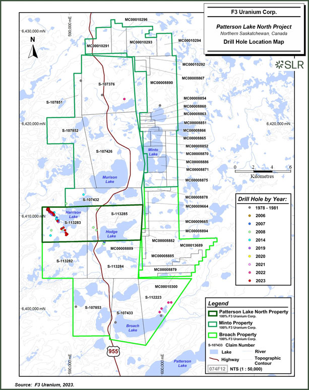
| 10-4 | |
| F3 Uranium Corp. | Patterson Lake North Project | January 25, 2023 |
| Report for NI 43-101 | SLR Project No.: 138.21599.00001 |
| 10.1 | Patterson Lake North Project |
| 10.1.1 | 2008 Drilling |
Between February 6 and April 15, 2008, Fission contracted Peak Drilling Ltd. of Courtenay, British Columbia, to conduct drilling operations over the PLN Property. In total, 15 drill holes were attempted, of which six holes totaling 2,121 m were completed. All holes were drilled vertically. As they were reconnaissance-scale holes, downhole deviation surveys were performed on only three drill holes due to technical problems with the tool and only minor deviation from vertical is assumed for the remaining completed holes. Nine holes had to be abandoned due to difficult overburden drilling conditions and thicknesses similar to the experiences in the 2006 and 2007 exploration programs. A downhole gamma survey was completed on three holes.
| 10.1.2 | 2014 Winter Drilling |
A drilling program consisting of five land- and ice-based diamond drill holes totaling 1,729.0 m was conducted from January 14 to February 9, 2014, by Bryson Drilling Ltd. on behalf of Fission 3.0 Corp. Drilling targeted electromagnetic conductors identified by ground electromagnetic surveys.
The A1 EM conductor was defined over 1.2 km in strike-length and its associated structure was successfully intercepted with four drill holes (PLN14-010, 011, 012, and 013). The structure, a mylonitic graphitic and sulphide rich pelitic gneiss, is geologically analogous to the PL3B conductor at Fission Uranium’s adjacent Patterson Lake South (PLS) project, along which high- grade uranium mineralization continues to be intercepted.
Drill holes PLN14-015/A were designed to test the B1 conductor along an inferred structure offsetting the A1 and B1 conductors. Due to the significant depth of Harrison Lake and challenging underlying overburden conditions the hole was lost during two attempts without reaching bedrock after casing to depths of 92.0 m and 116.0 m.
Pathfinder geochemistry indicated increased prospectivity along strike to the north and away from the southern terminus of the A1 ground EM conductor, where future drill programs will further test the A1 conductor.
The A3 EM conductor was drill-tested with one drill hole (PLN14-014); no graphitic or sulfidic lithologies to adequately explain the conductor was intercepted. Clay alteration near the top of the hole, although hosted within a non-prospective lithology, may indicate that the conductor was overshot. Re-visiting this target could be considered for future programs but does not represent an immediate priority due to the weak properties of the EM conductor in terms of conductivity thickness and overall length.
| 10.1.3 | 2014 Summer Drilling |
A diamond drill program consisting of six land-based holes totaling 2,127 m was conducted from June 15 to July 16, 2014, by Bryson Drilling Ltd. on behalf of Fission 3.0 Corp. Drilling followed-up prospective lithologies, structures and alteration as intersected during the Winter 2014 drill program and on electromagnetic conductors identified by ground electromagnetic surveys. Specifically, the drilling was mainly focused on further exploring and testing the A1 conductor that had been defined in the winter of 2014.
Five inclined drill holes (PLN14-016, PLN14-017, PLN14-018, PLN14-019 and PLN14-020) further testing the A1 conductor along 750 m of strike were completed to planned depths.
| 10-5 | |
| F3 Uranium Corp. | Patterson Lake North Project | January 25, 2023 |
| Report for NI 43-101 | SLR Project No.: 138.21599.00001 |
PLN14-017 and PLN14-019 both intersected radioactivity greater than 300 cps as measured on the GR-110 handheld scintillometer.
PLN14-019 intersected significant radioactivity which was confirmed by geochemical analysis and returned 397 ppm Uranium (or 0.047% U3O8) over 0.5 m within a broader six metre interval from 193.0 m to 199.0 m averaging 105 ppm Uranium (or 0.012% U3O8). Additionally, highly anomalous uranium concentrations (35 ppm) were found within the Athabasca Sandstone from 118.0 m -118.5 m.
The A4 conductor, as defined by a ground TDEM survey, was carried out in January 2014 and was successfully drill tested with one vertical hole (PLN14-021). However, no anomalous radioactivity was intersected.
| 10.1.4 | 2019 Winter Drilling |
A diamond drill program consisting of eight land-based holes totaling 2,051 m (including two drill holes lost due to bad ground conditions) was conducted from January 4 to February 6, 2019, by Bryson Drilling Ltd. on behalf of Fission 3.0 Corp. Drilling followed up prospective lithologies, structures and alteration but was primarily aimed to follow up results from historic drill hole PLN14-019 (6.0 m at 0.012 U3O8).
All six follow up drill holes failed to intersect significant anomalous radioactivity. Somewhat encouraging were the presence of millimeter scale black uranium flecks, presumably pitchblende, which correlated to slightly elevated radioactivity in PLN19-023B. At the end of the winter 2019 program the A1 conductor has been tested over 2.0 kilometers of strike length. Approximately 700 m of strike length remained within the PLN property boundaries. Due to the presence of anomalous uranium values including visible pitchblende mineralization and associated alteration, the systematic drill testing of the remaining 700 m of conductor strike was warranted and recommended.
| 10.1.5 | 2022 Winter Drilling |
A diamond drill program consisting of eight land-based holes totaling 4,172 m (including two drill holes lost and restarted due to bad ground conditions) was conducted from January 13 to March 23, 2022, by Bryson Drilling Ltd. on behalf of Fission 3.0 Corp. Drilling was aimed to test new conductors identified by historical ground geophysical work done in the N Conductor area as well as new geophysical work at Broach Lake done in 2021 that has been described in section 7.1 of this report.
Seven of the eight holes targeted the Broach Lake Conductor (Broach), and one targeted the N Conductor (Minto). PLN22-029 was an angled hole aiming to define the N conductor. Notable results include 1050 ppm - 1780 ppm boron from 560 m - 605 m. Additionally, the hole intersected anomalous radioactivity from 773.1 m -777.1 m, with an average of 19 ppm U Td.
Anomalous boron was intersected in holes at Broach Lake, the most notable was in hole PLN22-033, which detected 1510 ppm from 217.7 m - 218.2 m, in unconsolidated, altered sandstone.
| 10.1.6 | 2022 Fall Drilling |
A diamond drill program consisting of eight land-based holes totaling 3,223 m was conducted from November 10 to December 11, 2022, by Bryson Drilling Ltd. and Boart Longyear Ltd. on behalf of Fission 3.0 Corp. Drilling was aimed to further test the A1 conductor along strike based on updated geophysical models developed from new geophysics done in the areas since drilling in 2019 and to follow up on historic drilling of the A1 conductor. To overcome the challenges of casing overburden faced by previous drill programs, a sonic drill was employed to enable shallow angled holes. PLN22-034, PLN22-036 and PLN23-037 were all successful in intersecting the A1 conductor, and geochemistry indicated elevated base metals in the shear zone as well as elevated Boron in some samples, but no anomalous radioactivity was detected.
| 10-6 | |
| F3 Uranium Corp. | Patterson Lake North Project | January 25, 2023 |
| Report for NI 43-101 | SLR Project No.: 138.21599.00001 |
PLN22-035 (JR zone Discovery Hole) was an angled hole aimed to test the northwest extent of the A1 conductor at the same elevation of the anomalous radioactivity and elevated uranium observed in PLN14-019. The drill hole intersected broken dark brown sandstone with poor recovery and variable silicified fractures and dissolution. The unconformity at 227 m was unconsolidated and very friable and the top of basement was heavily hematite altered with patchy silicification and minor bleaching. At approximately 242.0 m, the rocks display evidence of shearing and started to become strongly bleached and clay altered. The A1 main shear zone was intersected from 252.0 m - 289.2 m where the basement is very broken-up and intensely altered including variable bleaching, clay, silicification and chlorite alteration as well as pervasive sericite alteration. Strongly anomalous radioactivity was recorded including a maximum of off scale radioactivity (>65,535 cps on the RS-125 Spec) in a zone of massive black pitchblende. Geochemical assays indicated the following:
| ● | 15.0 m at 6.97% U3O8 (257.5 m - 272.5 m), including: |
| ● | 5.5 m at 18.6% U3O8 (260.0 m - 265.5 m), further including: |
| ● | 1.0 m at 59.2% U3O8 (263.0 m - 264.0 m) |
Following the high-grade discovery at PLN22-035, holes PLN22-038, PLN22-039, PLN22-040, PLN22-041 were prioritized to further test the zone. All follow up holes intersected the A1 shear zone and further high-grade mineralization. The new discovery is named the JR zone. A mine grid was established perpendicular to the strike of the A1 EM conductor with PLN22-035 on line zero. From there, the grid extends in 15 m increments grid north and grid south; subsequent references to grid lines reference the distance in meters north or south along the grid from the discovery drill hole.
| 10.1.7 | 2023 Winter Drilling |
A diamond drill program consisting of twenty-one land-based holes totaling 7,575 m was conducted from January 8 to March 23, 2023, by Bryson Drilling Ltd. and Boart Longyear Ltd. on behalf of F3 Uranium. Drilling was aimed to further test the newly discovered JR zone that was intersected in the Fall 2022 program.
Drilling focused on expanding the JR zone along strike and up-dip toward the unconformity. The JR zone was successfully expanded to 105 m in length. Drilling highlights include PLN23-060 which intersected 14.5 m of mineralization at 9.4% U3O8. The intercept included 2.5 m of massive pitchblende assaying a 45.6% U3O8. PLN23-048 returned 13.5 m of mineralization at 5.3% U3O8. The zone remained open in all directions with follow up drilling planned for summer 2023.
| 10.1.8 | 2023 Summer Drilling |
A diamond drill program consisting of thirty-eight land-based holes totaling 13,542 m was conducted from June 9 to September 11, 2023, by Bryson Drilling Ltd. and Boart Longyear Ltd. on behalf of F3 Uranium. The main objective was to further test and expand the JR zone as well as continue to explore along the A1 conductor and test the parallel B1 conductor that was previously only defined by geophysics. Drilling expanded the JR zone approximately 156 m along strike and also in an up-dip direction as close as eight metres to the Athabasca Unconformity. Drilling highlights from summer 2023 include hole PLN23-068, which intersected 19 m of mineralization from 228.0 m -247.0 m including six meters of off-scale radioactivity.
| 10-7 | |
| F3 Uranium Corp. | Patterson Lake North Project | January 25, 2023 |
| Report for NI 43-101 | SLR Project No.: 138.21599.00001 |
In addition to expanding the JR zone, multiple holes were planned to test along the A1 conductor along strike roughly 2,600 m to the southeast. In nearly all cases, the A1 shear zone was successfully intersected but no anomalous radioactivity was detected.
The program also targeted a modeled EM conductor that runs parallel to the A1, named the B1 conductor. This conductor was successfully intersected with hole PLN23-078 on line 2640S. The conductor was defined with graphite-rich laminations and common sulfides distributed throughout. Additional smaller parallel shear zones were also intersected and accompanied by weak clay alteration, graphite-rich gouge and sulfides.
Following the intersection of the B1 conductor, a follow-up hole, PLN22-093 was planned to test the conductor on line 3450S. Athabasca Sandstone recovery was extremely poor due to unconsolidated sand and sandstone dissolution. Large-scale sandstone dissolution is interpreted to be indicative of intense alteration above the projected B1 shear zone. The Athabasca Unconformity was intersected deeper than expected. The top of basement exhibited strong clay alteration with varying bleaching and hematite alteration and clay and sericite rich shear zones. No anomalous radiation was detected, and the hole was terminated at 578.0 m. Reinterpretation using the actual unconformity depth indicates that the hole was approximately 100 m up-dip of the B1 Main Shear projection to the unconformity.
PLN23-095 targeted the top of the A1 main shear zone and the B1 shear zone at depth, on line 2610S. The A1 main shear zone was intersected and consisted of clay altered and weakly graphitic rock with numerous smaller clay-rich faults. The B1 main shear zone, where intersected, is graphite-rich and broken with some clay faults followed by additional stacked shear zones over a 50 m wide interval. Anomalous radioactivity of 300 cps was recorded, which was the first anomalous radioactivity recorded in association with B1 shear zone complex.
| 10.1.9 | 2023 Fall Drilling |
A diamond drill program consisting of 15 land-based holes totaling 6,267 m was conducted from September 12 to December 10, 2023, by Bryson Drilling Ltd. and Boart Longyear Ltd. on behalf of F3 Uranium. The purpose of the 2023 fall drilling was to 1) continue to expand uranium mineralization at the JR Zone and 2) follow up on the 2023 summer drilling results along the A1 and B1 conductors. Assay results of this drilling are currently in progress and are not yet available for review. Highlights of the 2023 fall drilling include:
| ● | PLN23-101 in the JR Zone intersected mineralization over a 10.50 m interval, including 1.42 m of high grade (>10,000 cps), of which 0.50 m was up to 54,400 cps radioactivity between 228.50 m and 229.00 m, extending mineralization up dip on line 015S from PLN23-044 |
| ● | PLN23-102, located 3.4 km south of the JR Zone, is the second hole to intersect anomalous radioactivity along the recently discovered and highly prospective B1 Shear Zone (B1). A handheld spectrometer measured 1,000 cps at a depth of 411 m. Hole PLN23-102 was drilled 840 m along strike to the south of PLN23-095 which was the first hole to encounter anomalous radioactivity at B1. The B1 conductor is parallel to the A1 Main Shear Zone, which hosts the JR Zone. |
| 10-8 | |
| F3 Uranium Corp. | Patterson Lake North Project | January 25, 2023 |
| Report for NI 43-101 | SLR Project No.: 138.21599.00001 |
| ● | Holes PLN23-102, 105, and 107 had abundant core loss in the overlying sandstone, which is interpreted to be due to the dissolution of sandstone. In contrast, hole PLN23-111 had improved sandstone recovery. This included more than 80 m of intense brecciation, faulting, local silicification, and clay alteration within the sandstone, along with significant dravite near the unconformity. Additionally, the drill hole intersected 13.6 m of a graphitic and clay-altered shear zone located approximately 90 m below the unconformity. |
| ● | The southern end of the A1 trend features significant vertical displacement; drill holes PLN23-078 and PLN23-095 (section line 2640S) were cored into bedrock with no Athabasca Sandstone present. Drill holes located grid south, including PLN23-115 and PLN23-111, have approximately 230 m of sandstone cover; this indicates the presence of a vertically offsetting and likely cross-cutting structure. |
| 10.2 | Drilling Methodology and Procedures |
Drilling at the Project was completed using diamond coring method using a Zinex A5 diamond drill rig. A Boart Longyear LS 600 sonic drill rig began casing the overburden in the fall of 2022 using large-diameter sonic casing to penetrate through quaternary sediments and installing smaller sized casing. Once casing was set, the sonic rig was moved off collar. The diamond drill was then moved on, and regular coring commenced with NQ-sized drill steel, which has an inside diameter of 60.2 mm. In some cases, when the NQ was refused, it was reduced to BQ- sized drill steel with an inside diameter of 46.1 mm. This process continued until the completion of the hole. The procedures used through all drilling campaigns are well documented in standard operating procedures and manuals.
Drill holes are generally drilled on 15 m spaced sections, with 10 m to 15 m drill hole spacings. Before Fall of 2022, vertical and inclined drill holes were used to target the mineralization, although most holes are steeper than -70º. Starting with the fall program of 2022, the use of the sonic drill to set casing allowed for shallower drill holes up to -45º. Drilling was largely designed to intersect the mineralized zones at roughly true thickness.
All mineralized and non-mineralized holes within the vicinity of the JR Zone deposit had a Van Ruth cementing plug set 20 m to 30 m below the shear zone and cemented to the top. Starting at PLN23-091, holes were cemented from hole bottom. The top 30 m of all non-mineralized holes outside the deposit areas are cemented as per Saskatchewan Ministry of Environment regulations.
| 10.2.1 | Drill Hole Surveys |
Holes were located on the mine grid, and collar sites were surveyed by differential GPS using NAD83 and UTM Zone 12. The collar locations were surveyed with a Trimble R10 RTK GPS system.
| 10.2.2 | Downhole Orientation Surveying |
Prior to drilling a hole, the drill rig is aligned with a TN-14 Rig Aligner to ensure it is set to the correct azimuth and inclination. F3 Uranium has used the TN-14 Rig Aligner for all drill holes since 2019.
Prior to 2019, downhole surveys were completed with either a Reflex EZ-Shot, a Reflex Gyro instrument, or a combination thereof. The Reflex EZ-shot, a single point instrument, was used to obtain dip and azimuth measurements at specified intervals down the hole, with an initial test taken below the casing and a final test at the bottom of the hole. By Winter 2022, the Reflex EZ- shot was used for ongoing drill hole surveys, while the end of hole orientation survey was primarily done with the SPT GyroMaster.
| 10-9 | |
| F3 Uranium Corp. | Patterson Lake North Project | January 25, 2023 |
| Report for NI 43-101 | SLR Project No.: 138.21599.00001 |
The SPT GyroMaster, a continuous multi-point instrument unaffected by magnetics, allows measurements to be made through drill rods. It was employed starting in the winter of 2019 and by the fall of 2022, all downhole orientation surveys were performed with this instrument.
| 10.2.3 | Downhole Radiometric Surveys |
Exploration drilling for uranium is unique due to the radioactive nature of uranium. Probes that measure the decay products or “daughters” can be measured with a downhole gamma probe; this process is referred to as gamma logging.
All holes were systematically probed within the rods using a Mount Sopris 500 m (4MXA-1000) or 1,000 m (4MXC-1000) winch. Prior to 2022, the Matrix logging console, and either a 2PGA- 1000,2GHF-1000 or QL40-GRA (SN5484) total gamma count probe were utilized upon completion of the hole.
From 2022 to present, all unmineralized or weakly mineralized holes are surveyed using a single crystal (Sodium Iodide, or NaI) QL40-GRA natural gamma ray probe (SN5484).
The probes are calibrated by running them in test pits maintained by the Saskatchewan Research Council (SRC) facilities in Saskatoon, Saskatchewan. These test pits consist of four variably mineralized holes with maximum grades of 0.61%, 0.30%, 1.35%, and 4.15% uraninite.
Gamma probe logs were used internally to guide drilling and sampling. Only U3O8 chemical assays are reported for the JR zone mineralization.
| 10.2.4 | Drill Core Logging |
Core recovery is generally very good, allowing for representative samples to be taken and accurate analyses to be performed.
The drill core is placed sequentially in wooden core boxes at the drill by the drillers. Twice daily, the core boxes are transported by F3 Uranium personnel to the core logging and sampling facility where depth markers are checked, and the core is carefully reconstructed as needed. The core is logged geotechnically on a run-by-run basis including the number of naturally occurring fractures, core recovery, rock quality designation (RQD), and range of radiometric counts per second. Prior to winter 2019 hand-held Exploranium GR-110 total count gamma-ray scintillometers were used to measure the radioactivity of the drill core. Starting in the winter 2019 drill program Radiation Solutions RS-121 Super Gamma-Ray Scintillometers were used. Drill holes PLN14-015 and PLN14-015A were not probed, surveyed, or logged as they failed to reach bedrock due to challenging overburden conditions. Starting in the Winter 2022 drill program, Radiation Solutions RS-125 Super-SPEC and RS-230 BDO Super-SPEC were used. By fall 2022, only a Radiation Solutions RS-125 Super-SPEC was used.
The core is descriptively logged utilizing a laptop computer by an F3 Uranium geologist paying particular attention to major and minor lithologies, alteration, structure, and mineralization. Logging and sampling information is entered into a spreadsheet-based template which is integrated into the Project digital database.
All drill core is photographed wet with a digital camera before splitting. Core boxes are marked with aluminum tags then stored.
| 10.2.5 | Drill Core Sampling |
Geochemical analysis that is conducted on the drill core consists of systematic composite or representative sampling throughout the sandstone and basement column, targeted and detailed sampling within areas of alteration, structure and/or radiometric anomalies, and systematic shortwave infrared spectral analysis (i.e., PIMA). Details of this type of sampling are provided below.
| 10-10 | |
| F3 Uranium Corp. | Patterson Lake North Project | January 25, 2023 |
| Report for NI 43-101 | SLR Project No.: 138.21599.00001 |
F3 Uranium sampling protocol calls for representative samples to be taken of both sandstone and basement lithologies. At least one representative sample of sandstone is taken when intersected. In thicker zones of sandstone (more than 10 m), representative samples are collected at 10 m intervals. Representative samples of basement lithologies consisting of 50 cm of split core (halved) are taken every 10 m within the basement, starting immediately in bedrock.
In addition to the representative samples, point samples are taken in both sandstone and basement lithologies in areas of interest including alteration and structural zones and areas of anomalous radioactivity. Beginning in Summer 2023, density measurements are taken every 20 m in the sandstone where possible.
All sandstone and basement intervals with handheld scintillometer readings greater than 300 cps, which indicate high levels of radioactivity, are continuously sampled with a series of 0.5 m split core samples.
In the SLR QP’s opinion, the logging and sampling procedures meet or exceed industry standards and are adequate for the purpose of future Mineral Resource estimation.
| 10.2.6 | Representative Sampling |
F3 Uranium sampling protocols call for representative samples to be taken for both sandstone and basement lithologies. The samples are continuous 50 cm of split core taken every 10 m starting from the top of the sandstone and continuing to the end of the hole. In areas of significant mineralization, intense alteration or faults, representative samples are not collected, and instead selective samples are taken.
Prior to summer 2023, composite samples of the sandstone were collected. These samples consisted of five-centimeter-long sections of core taken every 1.5 m over a 10 m interval. In areas of intense alteration or above the unconformity, sample intervals are reduced to five metres.
| 10.2.6.1 | Selective Sampling |
Selective samples are taken in basement and sandstone lithologies. Samples are taken from areas where interesting features related to structure, alteration and lithology exist. These samples are typically split core and are 50 cm long.
Structures can include any fault, fracture, broken or deformation zone within the core. Large structural zones or highly altered structures are often continuously sampled from top to bottom or at the discretion of a senior geologist.
Alteration refers to the chemical or physical changes in rocks caused by hydrothermal fluids or weathering. Discrete 0.5 m samples are taken in areas of increased alteration or changing alteration that could be of interest. In large areas of strong to intense alteration, evenly spaced 0.5 m split core samples are collected at the start of the alteration. The spacing of the samples varied with the width of the alteration zone as follows: one metre spacing for alteration zones less than or equal to five metres long, two metre spacing for alteration zones between five metre and 30 m long, and five metre spacing for alteration zones more than 30 m long.
| 10-11 | |
| F3 Uranium Corp. | Patterson Lake North Project | January 25, 2023 |
| Report for NI 43-101 | SLR Project No.: 138.21599.00001 |
Lithology is sampled at the geologist’s discretion; lithology sampling may be completed for a change in lithology, unknown lithologies, or lithologies that may be of interest, such as pegmatite sections or mafic intrusives.
| 10.2.6.2 | Mineralized Core Sampling |
F3 Uranium deems a section of the core as significantly mineralized when the handheld spectrometers (RS-125) display a reading greater than 300 cps. Any zone greater than or equal to 300 cps is continuously sampled at 0.5 m intervals. A two-metre shoulder of continuous 0.5 m samples is collected before and after the first and last sample measuring over 300 cps. If there are two or more mineralized zones, continuous samples are taken if the distance between each of the last shoulder samples is less than 10 m. Additionally, within mineralized zones, standards, duplicates, and density sample frequency is increased as described below.
| 10.2.6.3 | Density Sampling |
Density samples are taken in both mineralized and non-mineralized zones. In non-mineralized zones, density samples are taken every 20 m. Within mineralized zones density samples are included every two metres. For density analysis, a small (approximately five centimetre) piece of core is removed from within a 0.5 m sample and placed within a separate bag within the corresponding sample. Upon completion of the density analysis in the lab, the sample is returned to its original batch and further analyzed as needed along with the remaining sample.
| 10.2.6.4 | Insertion Rate |
F3 inserts blanks, duplicates, and certified reference material (CRMs or standards) into the analytical stream. One blank and one duplicate are inserted in every hole. At least one standard, one blank and one duplicate are inserted into the sampling stream for each hole that is mineralized, and with holes with high-grade mineralization up to four uranium standards are inserted. Standards were sourced from the Government of Canada and included standards with a range of U3O8 percentages.
| 10.2.6.5 | Sampling for PIMA Clay Analysis |
F3 Uranium took samples from the sandstone column, and these were sent to Rekasa Rocks Inc. to identify clay alteration species. Throughout the sandstone section, a two-centimetre to three-centimetre sample of core is collected every five metres. Near the unconformity, the sample interval width is reduced as needed. PIMA samples are also collected as required throughout the altered basement rocks, normally at five-metre intervals.
| 10.2.7 | Drill Core Storage |
Until August 2022, core from the drilling programs was stored at the Big Bear Lodge on Grygar Lake; since August 2022, all the core has been stored at a purpose-built storage facility located on the PLN Property.
| 10-12 | |
| F3 Uranium Corp. | Patterson Lake North Project | January 25, 2023 |
| Report for NI 43-101 | SLR Project No.: 138.21599.00001 |
| 11.0 | Sample Preparation, Analyses, and Security |
This section references the standard operating procedure (SOP) for Drill Hole Sampling Protocols for Core Drilling at the Project by F3 Uranium. The following sections contained in this Technical Report have been derived, and in some instances extracted, from documentation and standard operating procedures (SOP) supplied to SLR by F3 Uranium for review and audit.
Drill core from the Project was logged, marked for sampling, split, bagged, and sealed for shipment by F3 Uranium personnel at their secure, core-logging facility on the property. All samples for U3O8 assay were transported by land, in compliance with pertinent federal and provincial regulations, by Project personnel. The sample containers were transported directly to SRC Geoanalytical Laboratories in Saskatoon for sample preparation and analysis. The SRC laboratory is independent with ISO/IEC 17025: 2005 accreditation for the relevant procedures. The laboratory is licensed by the Canadian Nuclear Safety Commission (CNSC) for possession, transfer, import, export, use and storage of designated nuclear substances by CNSC Licence Number 01784-1-09.3. As such, the laboratory is closely monitored and inspected by the CNSC for compliance.
Analytical data results were sent electronically to F3 Uranium. These results were provided as a series of Adobe PDF files containing the official analytical results and a Microsoft Excel spreadsheet file containing only the analytical results. Upon receipt of the data, the electronic data was imported directly into the master drill hole database.
| 11.1 | Sample Preparation |
All core samples, including Composite Geochemical, Split, and Point samples were prepared by SRC. The sample preparation procedure that SRC performed on all submitted samples is described below.
Upon reaching SRC, the samples are sorted based on their matrix types, either sandstone or basement rock, and their radioactivity level. The samples are then prepared and analyzed in this sequence.
| ● | Samples are prepared (dried, crushed, and ground) in distinct facilities for sandstone and basement samples to minimize the chance of cross-contamination. Any radioactive samples that produced more than 2,000 cps are crushed and ground in a separate facility licensed by the CNSC for radioactive sample preparation. These radioactive materials are stored in a CNSC-licensed concrete bunker until they can be safely transported to the preparation facility by certified personnel. |
| ● | Sample drying is carried out at 75°C with the samples in their original bags in large, low temperature ovens. Upon drying, the samples are crushed to 60% and passed through a 2 mm steel jaw crusher. A 100 g to 200 g split is obtained from the crushed material using a riffle splitter. The split is ground to 90% and passed through 50 mesh using a chromium-steel puck-and-ring grinding mill for mineralized samples or a motorized agate mortar and pestle grinding mill for non-mineralized samples. The pulp is transferred to a clear plastic snap-top vial with the sample number labelled on the top. |
| ● | The grinding mills are cleaned with steel wool and compressed air after each sample run. If the samples are clay rich, silica sand is ground between the samples. |
| 11-1 | |
| F3 Uranium Corp. | Patterson Lake North Project | January 25, 2023 |
| Report for NI 43-101 | SLR Project No.: 138.21599.00001 |
Prior to geochemical analysis, sample material is digested into solution using several digestion methods:
| ● | A “total” three-acid digestion on a 250 mg aliquot of the sample pulp using a mixture of concentrated HF/HNO3/HClO4 acids to dissolve the pulp in a Teflon beaker over a hotplate; the residue, following drying, was dissolved in 15 mL of dilute ultrapure HNO3. |
| ● | A “partial” acid digestion, on a two-gram aliquot of the sample pulp, digested using 2.25 mL of an eight-to-one ratio of ultrapure HNO3 and HCl for one hour at 95ºC in a hot water bath and then diluted to 15 mL using deionized water. |
| ● | Another digestion method is a sodium peroxide fusion in which an aliquot of pulp is fused with a mixture of Na2O2 and NaCO3 in a muffle oven. The fused mixture is subsequently dissolved in deionised water. Boron is analyzed by inductively coupled plasma optical emission spectrometry on this solution. |
When SRC processes a batch of samples, they consistently include a duplicate from the batch, along with one of their own QC standards. In line with their quality control measures, F3 Uranium adds a field duplicate for every drill hole they complete and includes one blank sample per drill hole. All samples are stored at SRC’s laboratory for a period of two years. The pulps are stored indoors, while rejects are kept outdoors, unless specific instructions dictate otherwise. At present, SLR does not possess information regarding the location of the pulps and rejects.
| 11.2 | Drill Core Geochemistry Analysis |
All geochemistry core samples are analyzed by the ICP1 package offered by SRC, which includes 62 elements determined by inductively coupled plasma optical emission spectrometry (ICP-OES). All samples are also analyzed for boron using SRC’s ICP-OES Method. Analysis for uranium is conducted on mineralized samples using the ICP-OES Uranium Package in order to determine U3O8 wt%. For partial digestion analysis, samples are crushed to 60% passing -2 mm and a 100 g to 200 g sub-sample is split out using a riffler. The sub-sample is pulverized to 90% passing 106 µm using a standard puck and ring grinding mill. The sample is then transferred to a plastic snap top vial. An aliquot of pulp is digested in a mixture of HNO3:HCl in a hot water bath for an hour before being diluted by 15 mL of de-ionized water. The samples are then analyzed using a Perkin Elmer ICP-OES instrument (models DV5300 or DV8300). For total digestion analysis, an aliquot of pulp is digested to dryness in a hot block digester system using a mixture of concentrated HF:HNO3:HClO4. The residue is then dissolved in 15 mL of dilute HNO3 and analyzed using the same instrument(s) as above.
For boron analysis, an aliquot of pulp is fused in a mixture of NaO2/NaCO3 in a muffle oven. The fused melt is dissolved in de-ionized water and analyzed by ICP-OES.
| 11.3 | Drill Core PIMA Analysis |
Core samples for clay analysis are sent to Rekasa Rocks Inc., a private facility in Saskatoon, for analysis on a PIMA spectrometer using short wave infrared spectroscopy. Samples are air or oven dried prior to analysis to remove any excess moisture. Reflective spectra for the various clay minerals present in the sample were compared to the spectral results from Athabasca samples for which the clay mineral proportions have been determined to obtain a semi- quantitative clay estimate for each sample.
| 11.4 | Soil Sample Analysis |
Samples from the 2012 soil sampling program were submitted to SRC for analysis using the ICPMS1 package but with the partial digestion analysis replaced by aqua regia analysis. The ICPMS1 package is generally used to analyse unmineralized sandstones and has lower detection limits than the ICP-OES method. Total digestions are performed on an aliquot of sample pulp which is digested to dryness in a Teflon tube within a hot block digestion system using a mixture of concentrated HF:HNO3∙HClO4. The residue is then dissolved in dilute HNO3. For aqua regia, partial digestions are performed on an aliquot of sample for the requested elements by ICP-OES. An aliquot of pulp is digested in a test tube in a mixture of 3:1 HNO3:HCl, in a hot water bath and then diluted to 15 ml using de-ionized water.
| 11-2 | |
| F3 Uranium Corp. | Patterson Lake North Project | January 25, 2023 |
| Report for NI 43-101 | SLR Project No.: 138.21599.00001 |
| 11.5 | Drill Core Bulk Density Analysis |
Drill core samples collected for bulk density measurements are sent to SRC. Samples are first weighed as received and then submerged in de-ionized water and re-weighed. The samples are then dried until a constant weight is obtained. The sample is then coated with an impermeable layer of wax and weighed again while submersed in de-ionized water. Weights are entered into a database and the bulk density of each sample is calculated. Water temperature at the time of weighing is also recorded and used in the bulk density calculation.
| 11.6 | Quality Assurance and Quality Control |
Quality assurance (QA) consists of evidence to demonstrate that the assay data has precision and accuracy within generally accepted limits for the sampling and analytical method(s) used in order to have confidence in a resource estimate. Quality control (QC) consists of procedures used to ensure that an adequate level of quality is maintained in the process of collecting, preparing, and assaying the exploration drilling samples. F3 Uranium’s QA/QC program at PLN includes the following components:
| ● | Determination of accuracy – achieved by regular insertion of standards or certified reference materials (CRM) of known grade and composition. |
| ● | Determination of precision – achieved by regular insertion of duplicates for each stage of the process where a sample is taken or split. |
| ● | Checks for contamination – by insertion of blanks. |
The Project has a robust QA/QC process in place beginning in 2014. This includes the insertion of blanks, duplicates (field, coarse rejects, and pulps) throughout the period, and certified reference materials (CRM) into the assay sample stream sent to SRC. F3 Uranium is in the process of establishing an umpire laboratory verification assay samples process using the SGS laboratory (SGS), located in Lakefield, Ontario. A summary by type of the CRM, blanks, and duplicates inserted into the sample stream is presented in Table 11-1 while the frequency is summarized in Table 11-2.
Results from the QA/QC samples are continually tracked by F3 Uranium as certificates for each sample batch are received through 2023. If QA/QC samples of a sample batch pass within acceptable limits, the results of the sample batch are imported into the master database.
Results from the QA/QC program are documented in various reports by F3 Uranium. SLR relied on these reports in addition to independent verifications and review of QA/QC data. SLR considers the QA/QC protocols in place at PLN to be acceptable and in line with standard industry practice and is of the opinion that the resource database is suitable to estimate Mineral Resources for the PLN deposit.
| 11-3 | |
| F3 Uranium Corp. | Patterson Lake North Project | January 25, 2023 |
| Report for NI 43-101 | SLR Project No.: 138.21599.00001 |
| Table 11-1: | Summary of QA/QC Source and Type by Year |
| QA/QC | Sample | 2014 | 2019 | 2022 | 2023 | |||||
| Group | Source | QA/QC type | Sample Descriptions | Winter | Summer | Winter | Winter | Fall | Winter | Summer |
| 1 | F3 | InHouse (F3) blank samples (Sandstone) | Blanks | N | N | N | Y | - | Y | N |
| F3 | InHouse (F3) blank samples (Cinder Block) | Blanks | N | N | N | N | Y | N | N | |
| F3 | InHouse (F3) blank samples (Quartz Blank) | Blanks | Y | Y | N | N | N | N | Y | |
| 2 | CANMET | F3 inserted CANMET U3O8 wt.% CRM | UTS-3(LGR) | Y | Y | N | N | Y | Y | Y |
| CANMET | F3 inserted CANMET U3O8 wt.% CRM | DH-1A, *RL-1(MGR) | Y | N | N | Y | Y | Y | ||
| CANMET | F3 inserted CANMET U3O8 wt.% CRM | BL-5(HGR) | N | N | N | N | Y | Y | Y | |
| CANMET | F3 inserted CANMET U3O8 wt.% CRM | CUP-2(VHGR) | N | N | N | N | Y | Y | Y | |
| 3 | F3 & SRC | Partial and total (ppm) duplicates | Field Duplicate (FiD), Prep & Pulp Duplicates | Y | Y | N | N | Y | Y | Y |
| F3 & SRC | U3O8 TEST REPORT wt.% duplicates | Field Duplicate (FiD), Prep & Pulp Duplicates | Y | Y | N | N | Y | Y | Y | |
| F3 & SRC | SRC inserted CANMET U3O8 wt.% CRM standards | BL2A, BL4A, BL5, SRCU2 | Y | Y | Y | Y | Y | Y | Y | |
| F3 & SRC | SRC inserted internal ICP standards w/ varying Boron | ASR109/BL, ASR209/BM, ASR316/BSL18/BSN, CAR110/BL/BM, CAR218/BSH/BSL18/BSM/BSM/MA1B | Y | Y | Y | Y | Y | Y | Y | |
| 4 | SRC | ICP repeat analysis of same sample | Basement/BasementRA/Sandstone and Repeats | Y | Y | Y | Y | Y | Y | Y |
| SRC | U3O8 TEST REPORT wt.% repeats | Basement/BasementRA/Sandstone and Repeats | Y | Y | Y | Y | Y | Y | Y | |
| 5 | SRC | Specific Gravity Repeats | Sandstone/Basement/Repeats | Y | Y | N | N | Y | Y | Y |
| 11-4 | |
| F3 Uranium Corp. | Patterson Lake North Project | January 25, 2023 |
| Report for NI 43-101 | SLR Project No.: 138.21599.00001 |
| Table 11-2: | Summary of QA/QC Sampling Insertions by Year |
| Sample Type | W2014 | S2014 | W2019 | W2022 | F2022 | W2023 | S2023 | Total | %
of Total original samples |
%
of All Samples (original + QA/QC) |
%
of duplicate samples |
| Drill holes | 5 | 6 | 8 | 8 | 8 | 21 | 39 | 95 | N/A | ||
| Total Original Geochem Sample Count* | 415 | 494 | 506 | 1,327 | 809 | 1,959 | 4,639 | 10,149 | 100.0% | 82.8% | N/A |
| w/ U3O8 assays | 8 | 40 | 17 | 288 | 624 | 1,406 | 1,799 | 4,182 | 41.2% | 34.1% | N/A |
| ICP-OES only | 407 | 454 | 489 | 1,039 | 185 | 553 | 2,840 | 5,967 | 58.8% | 48.7% | N/A |
| Total QA/QC material frequency | 96 | 121 | 54 | 146 | 206 | 556 | 929 | 1,449 | 14.3% | 11.8% | N/A |
| Blanks | 4 | 6 | 0 | 13 | 9 | 26 | 38 | 96 | 0.9% | 0.8% | N/A |
| Field Duplicates | 14 | 13 | 0 | 0 | 9 | 21 | 38 | 95 | 0.9% | 0.8% | N/A |
| Coarse rejects (Prep Duplicates) | 14 | 13 | 0 | 0 | 9 | 21 | 38 | 95 | 0.9% | 0.8% | N/A |
| Pulp Duplicates | 14 | 13 | 0 | 0 | 9 | 21 | 38 | 95 | 0.9% | 0.8% | N/A |
| In House Reference materials | 4 | 7 | 0 | 0 | 16 | 64 | 67 | 158 | 1.6% | 1.3% | N/A |
| External Reference materials | 1 | 7 | 1 | 13 | 26 | 81 | 124 | 253 | 2.5% | 2.1% | N/A |
| Repeats & Re-analysis | 19 | 29 | 20 | 50 | 67 | 174 | 300 | 659 | 6.5% | 5.4% | N/A |
| Empire Reanalysis | 0 | 0 | 0 | 0 | 0 | 0 | 0 | 0 | 0.0% | 0.0% | 0% |
| Total Samples | 511 | 615 | 560 | 1473 | 1015 | 2515 | 5568 | 12257 | |||
| FU inserted blanks | 4 | 6 | 0 | 13 | 9 | 26 | 38 | 96 | 0.9% | ||
| FU inserted duplicates | 42 | 39 | 0 | 0 | 27 | 63 | 114 | 285 | 2.8% | ||
| Field duplicates (FiD + MinFiD) | 14 | 13 | 0 | 0 | 9 | 21 | 38 | 95 | 0.9% | ||
| U3O8 assays w/ field duplicates (MinFiD only) | 0 | 2 | 0 | 0 | 4 | 19 | 22 | 47 | 0.5% | ||
| Prep duplicates (PrepDupe+MinPrepDupe) | 14 | 13 | 0 | 0 | 9 | 21 | 38 | 95 | 0.9% | ||
| U3O8 assays w/ prep duplicates (MinPrepDupe only) | 0 | 2 | 0 | 0 | 4 | 19 | 22 | 47 | 0.5% | ||
| Pulp duplicates (PulpDupe + MinPulpDupe) | 14 | 13 | 0 | 0 | 9 | 21 | 38 | 95 | 0.9% | ||
| U3O8 assays w/ pulp duplicates (MinPulpDupe only) | 0 | 1 | 0 | 0 | 4 | 19 | 22 | 46 | 0.5% |
| 11-5 | |
| F3 Uranium Corp. | Patterson Lake North Project | January 25, 2023 |
| Report for NI 43-101 | SLR Project No.: 138.21599.00001 |
| Sample Type | W2014 | S2014 | W2019 | W2022 | F2022 | W2023 | S2023 | Total | %
of Total original samples |
%
of All Samples (original + QA/QC) |
%
of duplicate samples |
| FU inserted U3O8 standards | 4 | 7 | 0 | 0 | 16 | 64 | 67 | 158 | 1.6% | ||
| Very high grade reference (VHGR; 88.92 wt% U3O8 ) | 0 | 0 | 0 | 0 | 4 | 13 | 12 | 29 | 0.3% | ||
| High grade reference (HGR; 21/8.36 wt% U3O8 ) | 0 | 0 | 0 | 0 | 4 | 14 | 15 | 33 | 0.3% | ||
| Medium grade reference (MGR; 0.310 or 0.237 wt% U3O8 ) | 0 | 1 | 0 | 0 | 4 | 18 | 20 | 43 | 0.4% | ||
| Low grade reference (LGR; 541ppm/0.060 wt% U3O8 ) | 4 | 6 | 0 | 0 | 4 | 19 | 20 | 53 | 0.5% | ||
| Lab (SRC) inserted U3O8 standards | 1 | 7 | 1 | 13 | 26 | 81 | 124 | 253 | 2.5% | ||
| BL2A (0.502 wt% U3O8 ) | 0 | 0 | 0 | 0 | 4 | 9 | 15 | 28 | 0.3% | ||
| BL4A (0.147 wt% U3O8 ) | 1 | 7 | 1 | 13 | 13 | 52 | 72 | 159 | 1.6% | ||
| BL5 (8.36 wt% U3O8 ) | 0 | 0 | 0 | 0 | 5 | 10 | 22 | 37 | 0.4% | ||
| SRCU02 (1.58 wt% U3O8 ) | 0 | 0 | 0 | 0 | 4 | 10 | 15 | 29 | 0.3% | ||
| Lab (SRC) inserted ICP standards | 30 | 39 | 33 | 83 | 70 | 174 | 324 | 753 | 7.4% | ||
| ASR109/BL | 0 | 3 | 0 | 0 | 0 | 0 | 0 | 3 | 0.0% | ||
| ASR209/BM | 0 | 1 | 0 | 0 | 0 | 0 | 0 | 1 | 0.0% | ||
| ASR316/BSL18 | 0 | 0 | 2 | 19 | 9 | 20 | 29 | 79 | 0.8% | ||
| ASR316/BSM | 0 | 0 | 1 | 15 | 6 | 17 | 25 | 64 | 0.6% | ||
| ASR316/BSN | 0 | 0 | 0 | 1 | 0 | 0 | 0 | 1 | 0.0% | ||
| CAR110/BL | 17 | 21 | 0 | 0 | 0 | 0 | 0 | 38 | 0.4% | ||
| CAR110/BM | 13 | 14 | 0 | 0 | 0 | 0 | 0 | 27 | 0.3% | ||
| CAR218/BSH | 0 | 0 | 0 | 0 | 2 | 5 | 9 | 16 | 0.2% | ||
| CAR218/BSL18 | 0 | 0 | 17 | 24 | 22 | 55 | 115 | 233 | 2.3% | ||
| CAR218/BSM | 0 | 0 | 13 | 24 | 31 | 77 | 140 | 285 | 2.8% | ||
| CAR218/BSM/MA1B | 0 | 0 | 0 | 0 | 0 | 0 | 6 | 6 | 0.1% | ||
| Repeats & Re-analysis | 19 | 29 | 20 | 50 | 67 | 174 | 300 | 659 | 6.5% |
| 11-6 | |
| F3 Uranium Corp. | Patterson Lake North Project | January 25, 2023 |
| Report for NI 43-101 | SLR Project No.: 138.21599.00001 |
| Sample Type | W2014 | S2014 | W2019 | W2022 | F2022 | W2023 | S2023 | Total | %
of Total original samples |
%
of All Samples (original + QA/QC) |
%
of duplicate samples |
| U3O8 assays | 1 | 6 | 1 | 7 | 23 | 65 | 106 | 209 | 2.1% | ||
| ICP | 18 | 23 | 19 | 43 | 44 | 109 | 194 | 450 | 4.4% | ||
| Empire Lab | 0 | 0 | 0 | 0 | 0 | 0 | 0 | 0 | 0.0% | ||
| Prep duplicates (PrepDupe+MinPrepDupe) | 0 | 0 | 0 | 0 | 0 | 0 | 0 | 0 | 0.0% | ||
| Pulp duplicates (PulpDupe+MinPulpDupe) | 0 | 0 | 0 | 0 | 0 | 0 | 0 | 0 | 0.0% |
| 11-7 | |
| F3 Uranium Corp. | Patterson Lake North Project | January 25, 2023 |
| Report for NI 43-101 | SLR Project No.: 138.21599.00001 |
| 11.6.1 | Certified Reference Materials (CRM) |
Results of the regular submission of CRMs are used to identify issues with specific sample batches, and biases associated with the laboratory. F3 Uranium obtained CRMs from two different international laboratories (Canadian Centre for Mineral and Energy Technology (CANMET) and SRC) to account for different ranges of several chemical elements such as uranium, nickel, lead, and vanadium, as presented in Table 11-3. Results of the CRM sample analyses are plotted monthly in control charts with upper and lower limits of the acceptable values, defined as values above or below two and three standard deviations, and the certified value.
| Table 11-3: | Expected Values and Standard Deviation of CRMs |
| CRM | Sample Type | U % | U3O8 % | SD (U3O8 %) |
Source |
| UTS-3 | Low Grade. | 0.0513 | 0.0604 | 0.0010 | CANMET |
| DH-1a | Medium Grade. | 0.262 | 0.3100 | 0.0035 | CANMET |
| RL-1 | Medium Grade | 0.201 | 0.2370 | 0.0071 | CANMET |
| BL-5 | High Grade | 7.09 | 8.3600 | 0.0330 | CANMET |
| CUP-2 | Very High Grade | 75.42 | 88.9202 | 0.0809 | CANMET |
One of each CRM is inserted into the sample batch for each drill hole that intersected mineralization. CRM containers are shaken prior to use to ensure homogeneity and 15 g of material is required per sample. Samples are taken with clearly marked plastic spoons to avoid cross contamination between containers. For holes that do not intersect mineralization, no reference sample is inserted.
F3 Uranium submitted a total of 158 CRM samples for analysis at SRC, which corresponds to an insertion ratio of 1.39%. The laboratory’s precision and performance over time are graphically represented in Figure 11-1, specifically for uranium. The variation from the CRM’s mean value in standard deviations (SD) defines the QA/QC variance and is used to determine acceptability of the CRM sample assay. Results within +/- two standard deviations (±2SD) are considered acceptable. Failure criteria for CRM samples are met when either:
| 1 | Two consecutive samples return values outside two standard deviations from the mean, on the same side of the mean, or |
| 2 | Any sample returns a value outside three standard deviations (±3SD) from the mean. |
Overall, the control charts indicate good and consistent laboratory precision. Of the 158 samples, two samples for CUP-2 were out of the two standard deviation precision limits. No sample results were out of three standard deviation limits.
The SLR QP is of the opinion that the results of the CRM samples from 2014 to 2023 support the use of samples assayed at the SRC laboratory during this period in Mineral Resource estimation.
| 11-8 | |
| F3 Uranium Corp. | Patterson Lake North Project | January 25, 2023 |
| Report for NI 43-101 | SLR Project No.: 138.21599.00001 |
Figure 11-1: Uranium CRM Z-Score Control Chart
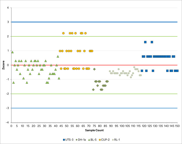
| 11.6.2 | Duplicates |
Duplicate samples are used to monitor preparation, assay precision, and grade variability as a function of sample homogeneity and laboratory error.
Three types of duplicate samples are submitted:
| 1 | Field duplicates |
| 2 | Preparation duplicates |
| 3 | Pulp duplicate |
The SLR QP analyzed, using statistics, scatter plots and quantile-quantile plots, a database with the results of 45 pairs of samples of field duplicates compiled by F3 Uranium staff. Results from the field, preparation, and pulp duplicate programs are plotted in Figure 11-2, Figure 11-3, and Figure 11-4. Four samples have a difference in results greater than 30%, which corresponds to an error rate of 8.9% (Figure 11-2). Prep and Pulp duplicates which provide a measure of the sample homogeneity at different stages of the preparation process show good precision and the SLR QP is of the opinion that the results of the filed duplicates show the preparation and analytical procedures of the laboratory are good and the data is suitable for use in resource estimations.
| 11-9 | |
| F3 Uranium Corp. | Patterson Lake North Project | January 25, 2023 |
| Report for NI 43-101 | SLR Project No.: 138.21599.00001 |
Figure 11-2: Field Duplicate Control Chart
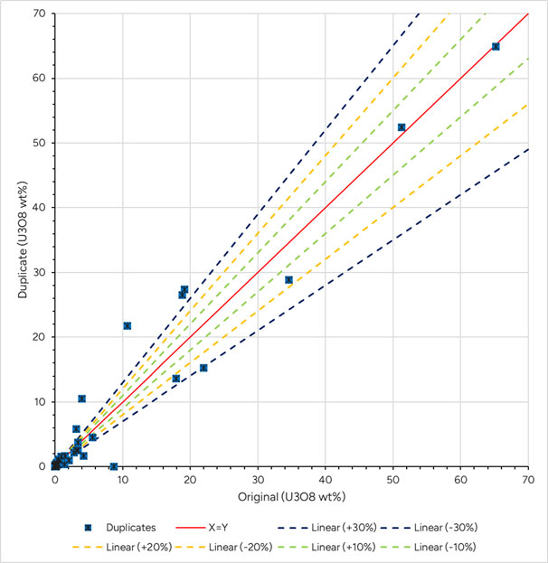
| 11-10 | |
| F3 Uranium Corp. | Patterson Lake North Project | January 25, 2023 |
| Report for NI 43-101 | SLR Project No.: 138.21599.00001 |
Figure 11-3: Preparation Duplicate Control Chart
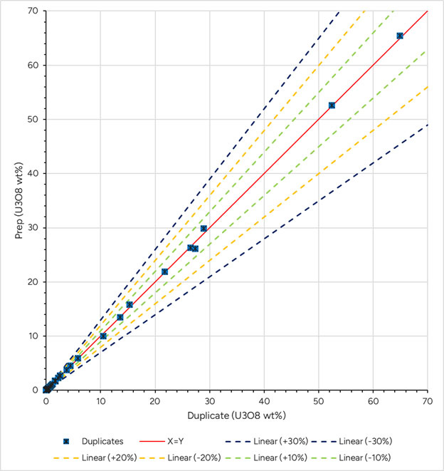
| 11-11 | |
| F3 Uranium Corp. | Patterson Lake North Project | January 25, 2023 |
| Report for NI 43-101 | SLR Project No.: 138.21599.00001 |
Figure 11-4: Pulp Duplicate Control Chart
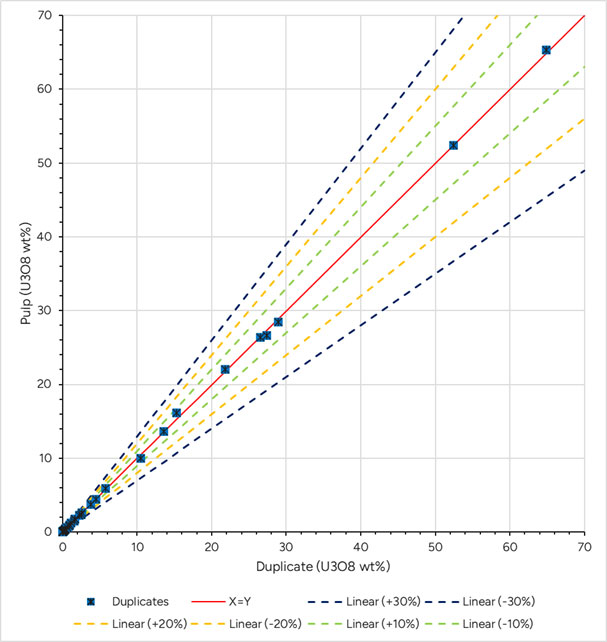
| 11-12 | |
| F3 Uranium Corp. | Patterson Lake North Project | January 25, 2023 |
| Report for NI 43-101 | SLR Project No.: 138.21599.00001 |
| 11.6.3 | Blanks |
Blank material is used to assess contamination or sample-cross contamination during sample preparation and to identify sample numbering errors. One blank sample is inserted for each drill hole that intersects mineralization. Prior to 2019, blank reference samples were not submitted for holes that did not intersect mineralization. Beginning in Winter 2022, at least one blank sample is inserted into each hole, regardless of mineralization.
Blank materials are changed from program to program. These materials are selected based on availability and chemical properties. In 2014, quartz blanks were used. In winter 2022 broken cinder blocks were submitted as blank material. In the fall 2022 and winter 2023 programs, inert sandstone sampled were submitted. Starting in the summer of 2023 quartz blanks, gathered from a barren quartz vein intersected in historic hole PL0703 were submitted.
Figure 11-5 indicates a few samples with low contamination results of 73 blank samples sorted by increasing sample analysis date. Blank material was inserted at a rate of less than 1.0%. A failure criterion for blank samples is met when a sample returns greater than 0.005% U3O8, which is a concentration five times greater than the detection limit of the instrument (0.001% U3O8). Zero sample failures were noted.
Figure 11-5: Blank Control Chart
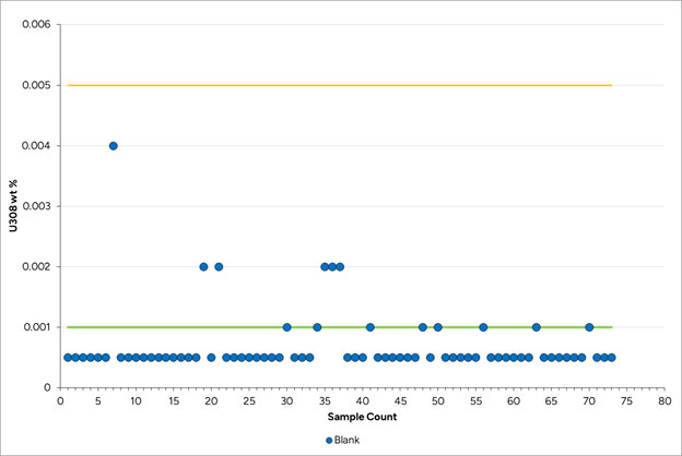
| 11-13 | |
| F3 Uranium Corp. | Patterson Lake North Project | January 25, 2023 |
| Report for NI 43-101 | SLR Project No.: 138.21599.00001 |
| 11.6.4 | SRC Internal QA/QC Program |
Quality control is maintained by all instruments at SRC being calibrated with certified materials. Independent of F3 Uranium’s QA/QC samples, standards are inserted into sample batches at regular intervals by SRC. Within each batch of 40 samples, one to two quality control samples are inserted. All quality control results must be within specified limits, otherwise corrective action is taken. If for any reason there is a failure in an analysis, the subgroup affected is reanalyzed.
Five U3O8 reference standards are used: UTS-3, RL-1, DH-1A, BL-5 and CUP-2, , which have known concentrations of 0.502% U3O8, 1.21% U3O8, 0.147% U3O8, 8.36% U3O8, and 1.58% U3O8, respectively. Except for SRCUO2 (produced in-house at SRC), all reference materials are certified and provided by CANMET.
SRC has developed and implemented a laboratory management system which operates in accordance with ISO/IEC 17025:2005 (CAN-P-4E), General Requirements for the Competence of Mineral Testing and Calibration Laboratories. The laboratory also participates in a certified interlaboratory testing program, CCRMP/PTP-MAL, for gold using lead fusion fire assay with an AAS finish.
All processes performed at the laboratory are subject to a strict audit program, which is performed by approved trained professionals. SRC is independent of F3 Uranium.
| 11.6.5 | Secondary Laboratory Check (Umpires) |
External duplicate samples (check assays) were collected at the final stage of Summer 2023 sample collection period and are currently being prepared to be sent to the umpire laboratory, SGS, for either U3O8% analysis or delayed neutron counting (DNC). SGS is ISO/IEC accredited and independent of F3 Uranium. Results of the secondary laboratory checks are not available for review.
| 11.7 | Sample Security |
Drill core is delivered directly to F3 Uranium’s core handling facility located on the PLN Property. After logging, splitting, and bagging, core samples for analysis are stored in a secured shipping container at the same facility. The shipping container is kept locked or under direct supervision of F3 Uranium personnel. A sample transmittal form is prepared and identifies each batch of samples.
SRC considers customer confidentially and security of utmost importance and takes appropriate steps to protect the integrity of sample processing at all stages from sample storage and handling to transmission of results. All electronic information is password protected and backed up on a daily basis. Electronic results are transmitted with additional security features. Access to SRC’s premises is restricted by an electronic security system. The facilities at the main laboratory are regularly patrolled by security guards 24 hours per day.
Official results are provided as a series of Adobe PDF files. A Microsoft Excel spreadsheet file containing only the analytical results is also provided. These files are sent using a secured password protected compressed file.
In the SLR QP’s opinion, the sampling methods, chain of custody procedures, and analytical techniques are appropriate and meet acceptable industry standards, and results are appropriate to estimate Mineral Resources.
| 11-14 | |
| F3 Uranium Corp. | Patterson Lake North Project | January 25, 2023 |
| Report for NI 43-101 | SLR Project No.: 138.21599.00001 |
| 11.8 | QP Opinion on Section 11 |
In the SLR QP’s opinion, the sample preparation, security, and analytical procedures meet industry standards, and the QA/QC program, as designed and implemented at PLN are adequate; consequently, the assay results within the drill hole database are suitable for mineral resource estimation purposes. Neither the SRC in-house quality control nor F3 Uranium quality control yielded any indication of quality concerns.
| 11-15 | |
| F3 Uranium Corp. | Patterson Lake North Project | January 25, 2023 |
| Report for NI 43-101 | SLR Project No.: 138.21599.00001 |
| 12.0 | Data Verification |
Data verification is the process of confirming that data has been generated with proper procedures, is transcribed accurately from its original source into the project database and is suitable for use as described in this Technical Report.
SLR was not directly involved in the exploration drilling, logging, and sampling programs that formed the basis for collecting the data that will be used to support the geological model and Mineral Resource Estimate (MRE) for the Project in the future.
All geological data has been reviewed and verified by SLR as being accurate to the extent possible and to the extent possible all geologic information was reviewed and confirmed. SLR did not conduct check sampling of the core. In the QP’s opinion the samples taken by F3 Uranium provide adequate and good verification of the data and SLR is of the opinion that the work has been done within the guidelines of NI 43-101.
| 12.1 | Data Verification Process |
As part of this Technical Report, all the historical data associated with the Project was compiled, organized, and entered into a Leapfrog Geo database by F3 Uranium and audited by the SLR QP for completeness and validity. The SLR QP used the information provided to validate the drilling database.
As part of the data verification procedure, drill data was spot checked and audited by the SLR QP for completeness and validity using standard database validation tests. In addition, the SLR QP reviewed the QA/QC methods and results, verified assay certificates against the database assay table, and completed one site visit that included a review of drill core. No limitations were placed on SLR’s data verification process. The review of the QA/QC program and results is presented in Section 11.0, Sample Preparation, Analyses and Security.
The SLR QP performed the following digital queries. No significant issues were identified.
| ● | Header table: searched for incorrect or duplicate collar coordinates and duplicate hole IDs. |
| ● | Survey table: searched for duplicate entries, survey points past the specified maximum depth in the collar table, and abnormal dips and azimuths. |
| ● | Core recovery table: searched for core recoveries greater than 100% or less than 80%, overlapping intervals, missing collar data, negative lengths, and data points past the specified maximum depth in the collar table. |
| ● | Lithology: searched for duplicate entries, intervals past the specified maximum depth in the collar table, overlapping intervals, negative lengths, missing collar data, missing intervals, and incorrect logging codes. |
| ● | Geochemical and assay table: searched for duplicate entries, sample intervals past the specified maximum depth, negative lengths, overlapping intervals, sampling lengths exceeding tolerance levels, missing collar data, missing intervals, and duplicated sample IDs. |
| ○ | Due to the nature of the sampling process, samples are only taken where scintillometer readings indicated mineralization. Previously identified gaps in the drilling assay table were treated as effectively barren and were assigned the value of 0.0001% U3O8. |
| 12-1 | |
| F3 Uranium Corp. | Patterson Lake North Project | January 25, 2023 |
| Report for NI 43-101 | SLR Project No.: 138.21599.00001 |
| 13.0 | Mineral Processing and Metallurgical Testing |
No mineral processing or metallurgical testing studies have been completed on the mineralization on the Property.
| 13-1 | |
| F3 Uranium Corp. | Patterson Lake North Project | January 25, 2023 |
| Report for NI 43-101 | SLR Project No.: 138.21599.00001 |
| 14.0 | Mineral Resource Estimate |
There are no current Mineral Resources at the Project.
| 14-1 | |
| F3 Uranium Corp. | Patterson Lake North Project | January 25, 2023 |
| Report for NI 43-101 | SLR Project No.: 138.21599.00001 |
| 15.0 | Mineral Reserve Estimate |
There are no current Mineral Reserves at the Project.
| 15-1 | |
| F3 Uranium Corp. | Patterson Lake North Project | January 25, 2023 |
| Report for NI 43-101 | SLR Project No.: 138.21599.00001 |
| 16.0 | Mining Methods |
This section is not applicable.
| 16-1 | |
| F3 Uranium Corp. | Patterson Lake North Project | January 25, 2023 |
| Report for NI 43-101 | SLR Project No.: 138.21599.00001 |
| 17.0 | Recovery Methods |
This section is not applicable.
| 17-1 | |
| F3 Uranium Corp. | Patterson Lake North Project | January 25, 2023 |
| Report for NI 43-101 | SLR Project No.: 138.21599.00001 |
| 18.0 | Project Infrastructure |
This section is not applicable.
| 18-1 | |
| F3 Uranium Corp. | Patterson Lake North Project | January 25, 2023 |
| Report for NI 43-101 | SLR Project No.: 138.21599.00001 |
| 19.0 | Market Studies and Contracts |
This section is not applicable.
| 19-1 | |
| F3 Uranium Corp. | Patterson Lake North Project | January 25, 2023 |
| Report for NI 43-101 | SLR Project No.: 138.21599.00001 |
| 20.0 | Environmental Studies, Permitting, and Social or Community Impact |
This section is not applicable.
| 20-1 | |
| F3 Uranium Corp. | Patterson Lake North Project | January 25, 2023 |
| Report for NI 43-101 | SLR Project No.: 138.21599.00001 |
| 21.0 | Capital and Operating Costs |
This section is not applicable.
| 21-1 | |
| F3 Uranium Corp. | Patterson Lake North Project | January 25, 2023 |
| Report for NI 43-101 | SLR Project No.: 138.21599.00001 |
| 22.0 | Economic Analysis |
This section is not applicable.
| 22-1 | |
| F3 Uranium Corp. | Patterson Lake North Project | January 25, 2023 |
| Report for NI 43-101 | SLR Project No.: 138.21599.00001 |
| 23.0 | Adjacent Properties |
The PLN Property is contiguous with claims held by various companies and individuals. As of the effective date of this Technical Report, the PLN Property is contiguous with claims registered in the names of a consortium consisting of HXC Corporation (6.25%) / Far West Mining Ltd. (43.75%) / Orano Canada Inc (50%) to the east; a consortium consisting of Purepoint Uranium Group (21%) / Cameco Corp (39.5%) / Orano Canada (39.5%) to the south and southeast; Orano, NexGen Energy, NexGen Energy/Atha Energy Corp and CanAlaska Uranium Ltd. to the west; and UEC Corp. / Orano Canada to the North (Figure 23-1).
SLR has not relied upon information from the adjacent properties in the writing of this TRS.
| 23-1 | |
| F3 Uranium Corp. | Patterson Lake North Project | January 25, 2023 |
| Report for NI 43-101 | SLR Project No.: 138.21599.00001 |
Figure 23-1: Adjacent Properties
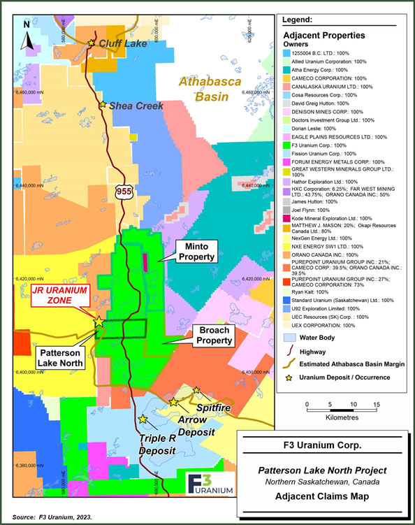
| 23-2 | |
| F3 Uranium Corp. | Patterson Lake North Project | January 25, 2023 |
| Report for NI 43-101 | SLR Project No.: 138.21599.00001 |
| 24.0 | Other Relevant Data and Information |
All relevant data and information regarding the Property is included in other sections of this Technical Report. There is no other relevant data or information available that is necessary to make the Technical Report understandable and not misleading.
| 24-1 | |
| F3 Uranium Corp. | Patterson Lake North Project | January 25, 2023 |
| Report for NI 43-101 | SLR Project No.: 138.21599.00001 |
| 25.0 | Interpretation and Conclusions |
SLR offers the following interpretations and conclusions on the Project:
| ● | The JR Zone deposit is considered an example of a basement-hosted vein-type or fracture-filled uranium deposit. |
| ● | To date, F3 Uranium and its predecessors have completed a total of 143 drill holes, totaling 49,945 m across the PLN Project. |
| ● | In the SLR QP’s opinion, the logging and sampling procedures meet or exceed industry standards and are adequate for Mineral Resource estimation. |
| ● | SLR reviewed and verified the resource database, including a review of the quality assurance (QA) and quality control (QC) methods and results, verifying assay certificates against the database assay table, standard database validation tests, and one site visit, including a drill core review. No limitations were placed on SLR’s data verification process. |
| ● | Based on the data validation and the results of the standard, blank, and duplicate analyses, the SLR QP is of the opinion that the sampling methods, chain of custody procedures, and analytical techniques are appropriate and meet acceptable industry standards. |
| ● | The assay and bulk density databases are of sufficient quality for Mineral Resource estimation at the JR Zone. |
| ● | Uranium mineralization at the PLN Property is hosted primarily within veins or fracture- filled metamorphosed basement lithologies and, to a much lesser extent, within overlying sedimentary rocks. Uranium mineralization has been intersected by surface drilling along two primary EM (electromagnetic) conductor trends: the A1 main shear zone (host of the JR Zone deposit) and B1 shear zone, which have a combined strike length of roughly 3.6 km. |
| 25-1 | |
| F3 Uranium Corp. | Patterson Lake North Project | January 25, 2023 |
| Report for NI 43-101 | SLR Project No.: 138.21599.00001 |
| 26.0 | Recommendations |
SLR offers the following recommendations regarding advancement of the Project:
F3 Uranium has proposed a total budget of C$14.60 million, as presented in Table 26-1, to advance the JR Zone and explore the remainder of the Project. The two categories of work are independent of each other.
| Table 26-1: | PLN 2024 Exploration Budget |
| Category | Item | Budget (C$) |
| Exploration | Drill testing of Broach Property | 2,500,000 |
| Drill testing of Minto Property | 1,500,000 | |
| Drill testing of B1 | 4,000,000 | |
| Exploration Subtotal | 8,000,000 | |
| JR Zone | Infill and Delineation drilling JR Zone | 6,500,000 |
| NI 43-101 Resource Estimate | 100,000 | |
| JR Zone Subtotal | 6,600,000 | |
| Total | 14,600,000 |
| 26-1 | |
| F3 Uranium Corp. | Patterson Lake North Project | January 25, 2023 |
| Report for NI 43-101 | SLR Project No.: 138.21599.00001 |
| 27.0 | References |
Alexandre, P., Kyser, K., Polito, P., and Thomas, D., 2005: Alteration mineralogy and stable isotope geochemistry of Paleoproterozoic basement-hosted unconformity-type uranium deposits in the Athabasca Basin, Canada. Economic Geology, 100(8), 1547-1563.
Annesley, I. R., Madore, C., & Portella, P. (2005). Geology and thermotectonic evolution of the western margin of the Trans-Hudson Orogen: evidence from the eastern sub-Athabasca basement, Saskatchewan. Canadian Journal of Earth Sciences, 42(4), 573-597.
Armitage, A. 2013. Technical Report on the Patterson Lake South Property, Northern Saskatchewan, dated April 14th, 2013, for Alpha Minerals Inc., 119 p. Posted on Sedar (www.sedar.com).
Bingham, D., and Legault, J. M., 2018: Geophysics of the Patterson Lake South Uranium Deposit, northwestern Saskatchewan. ASEG Extended Abstracts, 2018(1), 1-6.
Bingham, D, 2013a. Report on an Airborne Hi-Resolution Magnetic Survey over the Patterson Lake Property for Fission Energy Corp., field work performed August 4 – August 20, 2012, 59 p.
Bingham, D, 2013b. Report on 2012 Geophysical Surveys Over the Patterson Lake Property For Fission Uranium Corp., field work performed September - October, 2012, 31 p.
Campbell, J.E., 2007: Quaternary geology of the eastern Athabasca Basin, Saskatchewan and Alberta; in EXTECH IV: Geology and Uranium Exploration Technology of the Proterozoic Athabasca Basin., Saskatchewan and Alberta (ed.) C.W. Jefferson and G. Delaney; Geological Survey of Canada, Bulletin 588, pp. 211-228.
Card, C.D., 2002. New investigations of basement to the western Athabasca Basin; in Summary of Investigations 2002, Volume 2, Saskatchewan Geological Survey, Saskatchewan Energy and Mines, Miscellaneous Report 2002-4-2, 17 p.
Card, C.D., Pana, D., Stern., R.A., and Rayner, N., 2007: New insights into the geological history of the basement rocks to the southwestern Athabasca Basin, Saskatchewan and Alberta; in EXTECH IV: Geology and uranium EXploration TECHnology of the Proterozoic Athabasca Basin, Saskatchewan and Alberta. C.W. Jefferson and G. Delaney (eds.). Geological Survey of Canada, Bulletin 588, pp. 119-133.
Ghaffari, H., Huang, J., Donlon, P., Wittrup, M., Clifton, W., Mathisen, M., Mostert, M., Schmid, C., and Thompson, R., 2023. Feasibility Study, NI 43-101 Technical Report, for the PLS Property. January 17, 2023.
Glass, D.J. 1990. Lexicon of Canadian Stratigraphy, Volume 4-Western Canada; Canadian Society of Petroleum Geologists, Calgary, Alberta, 772 p.
Hanmer, S., Parrish, R., Williams, M., and Kopf, C., 1994: Striding-Athabasca mylonite zone: complex Archean deep crustal deformation in the East Athabasca mylonite triangle, northern Saskatchewan; Canadian Journal of Earth Sciences, v.31, pp. 1287-1300.
Hanmer, S., 1997: Geology of the Striding-Athabasca mylonite zone, northern Saskatchewan and southeastern District of Mackenzie, NWT; Geological Survey of Canada, Bulletin 501, 92 p.
Hobson, G.D. and MacAulay, H.A., 1969: A seismic reconnaissance survey of the Athabasca Formation, Alberta and Saskatchewan (part 74) (a co-operative venture with the Saskatchewan Department of Mineral Resources); Geological Survey of Canada, Paper 69-18, 23 p.
| 27-1 | |
| F3 Uranium Corp. | Patterson Lake North Project | January 25, 2023 |
| Report for NI 43-101 | SLR Project No.: 138.21599.00001 |
Hoeve, J., 1984: Host rock alteration and its application as an ore guide at the Midwest Lake uranium deposit, northern Saskatchewan. CIM Bull.;(Canada), 77(868).
Hoeve, J., and Quirt, D., 1987: A stationary redox front as a critical factor in the formation of high-grade, unconformity-type uranium ores in the Athabasca Basin, Saskatchewan, Canada. Bulletin de Minéralogie, 110(2), 157-171.
Jefferson, C. W., Thomas, D., Quirt, D., Mwenifumbo, C. J., and Brisbin, D. ,2007: Empirical Models for Canadian Unconformity-Associated Uranium Deposits
Jefferson, C.W., Thomas, D.J., Gandhi, S.S., Ramaekers, P., Delaney, G., Brisbin, D., Cutts, C., Portella, P., and Olson, R.A., 2007: Unconformity-associated uranium deposits of the Athabasca Basin, Saskatchewan and Alberta; in EXTECH IV: Geology and Uranium Exploration Technology of the Proterozoic Athabasca Basin, Saskatchewan and Alberta, (ed.) C.W. Jefferson and G. Delaney; Geological Survey of Canada, Bulletin 588, pp. 23- 76.
Jefferson, C.W., and Delaney, G., Geological Survey of Canada, Bulletin 588, pp. 89-117.
Johnstone, D. D., Bethune, K. M., Card, C. D., and Tschirhart, V., 2021: Structural evolution and related implications for uranium mineralization in the Patterson Lake corridor, southwestern Athabasca Basin, Saskatchewan, Canada. Geochemistry: Exploration, Environment, Analysis, 21(1), geochem2020-030.
Lewry, J. and Sibbald, T.I.I., 1977: Variation in lithology and tectonometamorphic relationships in the Precambrian basement of northern Saskatchewan; Canadian Journal of Earth Sciences v.14, pp. 1453- 1467.
Lewry, J. and Sibbald, T.I.I., 1980: Thermotectonic evolution of the Churchill Province in northern Saskatchewan; in Tectonophysics, v.68, pp. 45-82.
Macdonald, C., 1980: Mineralogy and geochemistry of a Precambrian regolith in the Athabasca Basin; M.Sc thesis, University of Saskatchewan, Saskatoon, Saskatchewan, 151 p.
Marshall, I.B., and Schutt, P.H., 1999: A national ecological framework for Canada – Overview. A co-operative product by the Ecosystems Science Directorate, Environment Canada and Research Branch, Agriculture and Agri-Foods Canada.McCallum, N. 2008. Report on the 2007 and 2008 Exploration of the Patterson Lake Property, Northern Saskatchewan for Fission Energy Corp. Submitted October 16, 2008, 23 p.
McNicoll, V.J., Theriault, R.J., and McDonough, M.R., 2000: Talston basement gneissic rocks: U-Pb and Nd isotopic constraints on the basement to the Paleoproterozoic Talston magmatic zone, northeastern Alberta; Canadian Journal of Earth Sciences, v.37, no 11, pp. 1575-1596.
Padbury, G. A., Acton, D. F., Stushnoff, C. T., University of Regina Canadian Plains Research Center, & Saskatchewan Environment and Resource Management. (1998). Ecoregions of Saskatchewan. Canadian Plains Research Center.
Palmer, K., 2010. Technical Report on the Shea Creek Property, Saskatchewan, Including Mineral Resource Estimates for the Kianna, Anne and Colette Deposits. 43-101 Report prepared for UEX Corporation, 214 p. Filed on SEDAR.
Quirt, D. H., 2003: Athabasca unconformity-type uranium deposits: One deposit type with many variations.
| 27-2 | |
| F3 Uranium Corp. | Patterson Lake North Project | January 25, 2023 |
| Report for NI 43-101 | SLR Project No.: 138.21599.00001 |
Ramaekers, P. (1979). Stratigraphy of the Athabasca Basin; Summary of Investigations 1979, Saskatchewan Geological Survey, Saskatchewan Mineral Resources, Miscellaneous Report 79-10, pp.154-160.
Ramaekers, P. (2004). Development, Stratigraphy and Summary Diagenetic History of the Athabasca Basin, Early Proterozoic of Alberta and Its Relation to Uranium Potential, AGS/EUB Special Report 62, pp. 1-85.
Ramaekers, P., Jefferson, C.W., Yeo, G.M., Collier, B., Long, D.G.F., Drever, G., McHardy, S., Jiricka, D., Cutts, C., Wheatley, K., Catuneanu, O., Bernier, S., and Post, R.T., 2007: Revised geological map and stratigraphy of the Athabasca Group, Saskatchewan and Alberta; in EXTECH IV: Geology and Uranium Exploration Technology of the Proterozoic Athabasca Basin., Saskatchewan and Alberta (ed.) C.W. Jefferson and G. Delaney; Geological Survey of Canada, Bulletin 588, pp. 155-191.
Ramaekers, P., 2013. Patterson Lake North: Field Work 2012. Work carried out for Fission Uranium Corporation (Formerly Fission-Energy Corp.), work performed August 9 to 22, 2012, 24 p.
Rhys, D. A., Horn, L., and Eriks, R. S., 2009. Technical Report on the Shea Creek Property, Northern Saskatchewan, 43-101 Report prepared for UEX Corporation, 117 p. Filed on SEDAR.
Smith, D., and Dahrouge, J., 2006. 2005 and 2006 Exploration of the Patterson Lake Property, Northern Saskatchewan. Confidential assessment report submitted to the Saskatchewan Energy and Resources, October 19, 2006, 13 p.
Smith, D., and Dahrouge, J., 2007. 2006 and 2007 Exploration of the Patterson Lake Property, Northern Saskatchewan. Confidential assessment report submitted to the Saskatchewan Energy and Resources, October 16, 2007, 12 p.
Smith, R.E., Veldhuis, H., Mills, G.F., Eilers, R.G., Fraser, W.R., & Lelyk, G.W. (1998). Terrestrial ecozones, ecoregions and ecodistricts of Manitoba: An ecological stratification of Manitoba’s natural landscapes (Technical Bulletin 1998-9E). Agriculture and Agri-Food Canada
Statistics Canada. (2021). Profile table, Census Profile, 2021 Census of Population - Saskatoon, City (CY) [Census subdivision], Saskatchewan. Sopuck, V.J., Carla, A de., Wray, E.M., and Cooper, B. (1983). The Application of Lithogeochemistry in the search for Unconformity-type Uranium Deposits, Northern Saskatchewan, Canada. Journal of Geochemical Exploration, 19, pp. 77-99.
Williams, M.L., Melis, E.A., Kopf, C.F., and Hanmer, S., 2000: Microstructural tectonometamorphic processes and the development of gneissic layering: a mechanism for metamorphic segregation; Journal of Metamorphic Geology, v.18, pp. 41 – 57.
Wallis, R.H., 1970: The geology of the Dufferin Lake area (west half) Saskatchewan; Saskatchewan Geological Department of Mineral Resources, Report 132, 59 p.
Yeo, G.M., and Delaney, G., 2007: The Wollaston Supergroup, stratigraphy and metallogeny of a Paleoproterozoic Wilson cycle in the Trans-Hudson Orogen, Saskatchewan; in EXTECH IV: Geology and Uranium Exploration Technology of the Proterozoic Athabasca Basin., Saskatchewan and Alberta (eds.)
Zenghua, L., Guoxiang, C., Bethune, K. M., David, T., and Gerard, Z., 2017: Structural controls on fluid flow during compressional reactivation of basement faults: insights from numerical modeling for the formation of unconformity-related uranium deposits in the Athabasca Basin, Canada. Economic Geology, 112(2), 451-466.
| 27-3 | |
| F3 Uranium Corp. | Patterson Lake North Project | January 25, 2023 |
| Report for NI 43-101 | SLR Project No.: 138.21599.00001 |
| 28.0 | Date and Signature Date |
This report titled “Technical Report on the Patterson Lake North Project, Northern Saskatchewan, Canada” with an effective date of November 20, 2023 was prepared and signed by the following authors:
| (Signed and Sealed) Mark B. Mathisen, C.P.G. | |
| Dated at Lakewood, CO | Mark B. Mathisen, C.P.G. |
| January 25, 2023 |
| 28-1 | |
| F3 Uranium Corp. | Patterson Lake North Project | January 25, 2023 |
| Report for NI 43-101 | SLR Project No.: 138.21599.00001 |
| 29.0 | Certificate of Qualified Person |
| 29.1 | Mark B. Mathisen |
I, Mark B. Mathisen, C.P.G., as an author of this report entitled “Technical Report on the Patterson Lake North Project, Northern Saskatchewan, Canada” with an effective date of November 20, 2023, prepared for F3 Uranium Corp., do hereby certify that:
| 1. | I am Principal Geologist with SLR International Corporation, of Suite 100, 1658 Cole Boulevard, Lakewood, CO, USA 80401. |
| 2. | I am a graduate of Colorado School of Mines in 1984 with a B.Sc. degree in Geophysical Engineering. |
| 3. | I am a Registered Professional Geologist in the State of Wyoming (No. PG-2821), a Certified Professional Geologist with the American Institute of Professional Geologists (No. CPG-11648), and a Registered Member of SME (RM #04156896). I have worked as a geologist for a total of 23 years since my graduation. My relevant experience for the purpose of the Technical Report is: |
| ● | Mineral Resource estimation and preparation of NI 43-101 Technical Reports. |
| ● | Director, Project Resources, with Denison Mines Corp., responsible for resource evaluation and reporting for uranium projects in the USA, Canada, Africa, and Mongolia. |
| ● | Project Geologist with Energy Fuels Nuclear, Inc., responsible for planning and direction of field activities and project development for an in situ leach uranium project in the USA. Cost analysis software development. |
| ● | Design and direction of geophysical programs for US and international base metal and gold exploration joint venture programs. |
| 4. | I have read the definition of “qualified person” set out in National Instrument 43-101 (NI 43- 101) and certify that by reason of my education, affiliation with a professional association (as defined in NI 43-101) and past relevant work experience, I fulfill the requirements to be a “qualified person” for the purposes of NI 43-101. |
| 5. | I visited the PLN Project on August 29, 2023. |
| 6. | I am responsible for overall preparation of the Technical Report. |
| 7. | I am independent of the Issuer applying the test set out in Section 1.5 of NI 43-101. |
| 8. | I have had no prior involvement with the property that is the subject of the Technical Report. |
| 9. | I have read NI 43-101, and the Technical Report has been prepared in compliance with NI 43-101 and Form 43-101F1. |
| 10. | At the effective date of the Technical Report, to the best of my knowledge, information, and belief, the Technical Report contains all scientific and technical information that is required to be disclosed to make the Technical Report not misleading. |
Dated this 25th day of January, 2024, Mark B. Mathisen, C.P.G.
| 29-1 | |
| F3 Uranium Corp. | Patterson Lake North Project | January 25, 2023 |
| Report for NI 43-101 | SLR Project No.: 138.21599.00001 |

Making Sustainability Happen