| respec.com S-K1300 TECHNICAL REPORT SUMMARY PILOT MOUNTAIN TUNGSTEN PROJECT MINERALCOUNTY, NEVADA, USA REPORT RSI-3732 PREPARED BY RESPEC 210 South Rock Boulevard Reno, Nevada 89502 United States PREPARED FOR Guardian Metal Resources PLC Salisbury House, London Wall London EC2M 5PS United Kingdom DECEMBER 15,2025 Project Number M0488.25002 |
| RSI-3732 i 2 RESPEC Company, LLC 3824 Jet Drive Rapid City, SD 57703 Consent of RESPEC Company,LLC In connection with the Guardian Metal Resources PLC’s Registration Statement on Form F-1 (the “Registration Statement”), the undersigned consents to: i. The filing of the technical report summary titled “S-K 1300 Technical Report Summary Pilot Mountain Tungsten Project, Mineral County, Nevada, USA” (the “Pilot Mountain TRS”), with an effective date of December 15, 2025, as an exhibit to and referenced in the Form F-1; ii. the incorporation by reference of the Pilot Mountain TRS in the Registration Statement, any other periodic reports filed by the company, including amendments or supplements thereto; iii. the use of and references to our name in connection with the Pilot Mountain TRS and the Registration Statement, any other periodic reports filed by the company, including amendments or supplements thereto; and iv. the information derived, summarized, quoted or referenced from the Pilot Mountain TRS, or portions thereof, that was prepared by us, that we supervised the preparation of, and/or that was reviewed and approved by us, that is included or incorporated by reference in the Registration Statement. RESPEC Company, LLC, is responsible for authoring, and this consent pertains to, the following sections of the Pilot Mountain TRS: All sections of the report excluding Section 1.4, Section 10.0, and Section 17.0. Report Effective Date: December 15, 2025 Consent Date: February 26, 2026 _______________________ Michael S. Lindholm RESPEC Company, LLC /s/ Michael S. Lindholm |
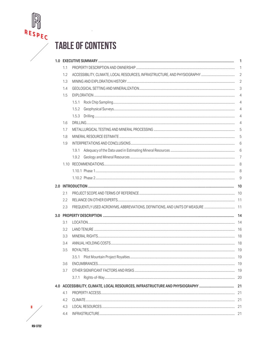
| RSI-3732 ii 2 TABLE OF CONTENTS 1.0 EXECUTIVE SUMMARY .................................................................................................................................................... 1 1.1 PROPERTY DESCRIPTION AND OWNERSHIP ................................................................................................................................. 1 1.2 ACCESSIBILITY, CLIMATE, LOCAL RESOURCES, INFRASTRUCTURE, AND PHYSIOGRAPHY ............................................ 2 1.3 MINING AND EXPLORATION HISTORY............................................................................................................................................. 2 1.4 GEOLOGICAL SETTING AND MINERALIZATION............................................................................................................................. 3 1.5 EXPLORATION ........................................................................................................................................................................................ 4 1.5.1 Rock Chip Sampling............................................................................................................................................................... 4 1.5.2 Geophysical Surveys.............................................................................................................................................................. 4 1.5.3 Drilling ....................................................................................................................................................................................... 4 1.6 DRILLING.................................................................................................................................................................................................. 4 1.7 METALLURGICAL TESTING AND MINERAL PROCESSING .......................................................................................................... 5 1.8 MINERAL RESOURCE ESTIMATE ....................................................................................................................................................... 5 1.9 INTERPRETATIONS AND CONCLUSIONS........................................................................................................................................ 6 1.9.1 Adequacy of the Data used in Estimating Mineral Resources.................................................................................... 6 1.9.2 Geology and Mineral Resources......................................................................................................................................... 7 1.10 RECOMMENDATIONS........................................................................................................................................................................... 8 1.10.1 Phase 1...................................................................................................................................................................................... 8 1.10.2 Phase 2...................................................................................................................................................................................... 9 2.0 INTRODUCTION ............................................................................................................................................................... 10 2.1 PROJECT SCOPE AND TERMS OF REFERENCE............................................................................................................................. 10 2.2 RELIANCE ON OTHER EXPERTS......................................................................................................................................................... 11 2.3 FREQUENTLY USED ACRONYMS, ABBREVIATIONS, DEFINITIONS, AND UNITS OF MEASURE ........................................ 11 3.0 PROPERTY DESCRIPTION ............................................................................................................................................... 14 3.1 LOCATION................................................................................................................................................................................................ 14 3.2 LAND TENURE ........................................................................................................................................................................................ 16 3.3 MINERAL RIGHTS................................................................................................................................................................................... 18 3.4 ANNUAL HOLDING COSTS.................................................................................................................................................................. 18 3.5 ROYALTIES............................................................................................................................................................................................... 19 3.5.1 Pilot Mountain Project Royalties......................................................................................................................................... 19 3.6 ENCUMBRANCES................................................................................................................................................................................... 19 3.7 OTHER SIGNIFICANT FACTORS AND RISKS ................................................................................................................................... 19 3.7.1 Rights-of-Way.......................................................................................................................................................................... 20 4.0 ACCESSIBILITY, CLIMATE, LOCAL RESOURCES, INFRASTRUCTURE AND PHYSIOGRAPHY ...................................... 21 4.1 PROPERTY ACCESS............................................................................................................................................................................... 21 4.2 CLIMATE................................................................................................................................................................................................... 21 4.3 LOCAL RESOURCES.............................................................................................................................................................................. 21 4.4 INFRASTRUCTURE................................................................................................................................................................................. 21 |
| RSI-3732 iii 2 TABLE OF CONTENTS(CONTINUED) 4.5 PHYSIOGRAPHY ..................................................................................................................................................................................... 21 5.0 HISTORY........................................................................................................................................................................... 23 5.1 EXPLORATION HISTORY ...................................................................................................................................................................... 23 5.1.1 Exploration - 1900-1978..................................................................................................................................................... 23 5.1.2 Exploration - 2011-2021..................................................................................................................................................... 24 5.2 HISTORICAL MINERAL RESOURCE ESTIMATES............................................................................................................................ 25 6.0 GEOLOGICAL SETTING, MINERALISATION, AND DEPOSIT........................................................................................... 26 6.1 GEOLOGICAL SETTING......................................................................................................................................................................... 26 6.1.1 Regional Geology.................................................................................................................................................................... 26 6.1.2 Property Geology.................................................................................................................................................................... 27 6.2 DEPOSIT TYPE ........................................................................................................................................................................................ 31 6.3 MINERALIZATION................................................................................................................................................................................... 32 6.3.1 Desert Scheelite...................................................................................................................................................................... 32 6.3.2 Garnet........................................................................................................................................................................................ 32 6.3.3 Gunmetal .................................................................................................................................................................................. 32 7.0 EXPLORATION.................................................................................................................................................................. 34 7.1 ROCK CHIP SAMPLING......................................................................................................................................................................... 34 7.2 GEOPHYSICAL SURVEYS ..................................................................................................................................................................... 35 7.3 DRILLING.................................................................................................................................................................................................. 35 8.0 SAMPLE PREPARATION, ANALYSIS, AND SECURITY .................................................................................................... 37 8.1 SAMPLE METHODS AND QA/QC ....................................................................................................................................................... 37 8.1.1 Guardian Metals Sampling Methods................................................................................................................................. 37 8.1.2 Historical Sampling Methods.............................................................................................................................................. 38 8.2 SAMPLE PREPARATION....................................................................................................................................................................... 38 8.2.1 Guardian Metals Sample Preparation and Analytical Methods.................................................................................. 38 8.2.2 Historical Sample Preparation and Analytical Methods............................................................................................... 39 8.3 QUALITY ASSURANCE/QUALITY CONTROL.................................................................................................................................... 40 8.3.1 Guardian Metals QA/QC results.......................................................................................................................................... 40 8.4 QP OPINION............................................................................................................................................................................................. 47 9.0 DATA VERIFICATION ....................................................................................................................................................... 49 9.1 SITE VISITS AND PERSONAL INSPECTIONS ................................................................................................................................... 49 |
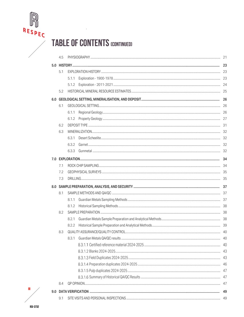
| RSI-3732 iv 2 TABLE OF CONTENTS(CONTINUED) 9.2 DRILL-HOLE DATA VERIFICATION .................................................................................................................................................... 49 9.2.1 Drill-Hole Collar Locations................................................................................................................................................... 49 9.2.2 Down-Hole Surveys................................................................................................................................................................ 53 9.2.3 Assays........................................................................................................................................................................................ 53 9.3 LIMITATIONS........................................................................................................................................................................................... 57 9.4 ADEQUACY OF DATA ............................................................................................................................................................................ 57 10.0 MINERAL PROCESSING AND METALLURGICAL TESTING............................................................................................. 58 10.1 ANALYTICAL PROCEDURES................................................................................................................................................................ 58 10.2 MINERALIZATION................................................................................................................................................................................... 58 10.3 LABORATORIES...................................................................................................................................................................................... 58 10.3.1 Amdel Laboratories................................................................................................................................................................ 58 10.3.2 Guangdong Institute of Resources Comprehensive Utilization.................................................................................. 59 10.3.3 Guangzhou Research Institute of Non-ferrous Metals................................................................................................. 59 10.4 TESTING RESULTS AND RECOVERY ESTIMATES.......................................................................................................................... 59 10.5 CONCLUSIONS ON DATA ADEQUACY ............................................................................................................................................. 60 11.0 MINERAL RESOURCE ESTIMATES .................................................................................................................................. 61 11.1 DATABASE ............................................................................................................................................................................................... 63 11.2 GEOLOGIC MODEL................................................................................................................................................................................ 64 11.3 MINERAL DOMAINS .............................................................................................................................................................................. 64 11.4 SPECIFIC GRAVITY................................................................................................................................................................................. 67 11.5 ASSAY CODING, CAPPING, AND COMPOSITING ........................................................................................................................... 67 11.6 VARIOGRAPHY........................................................................................................................................................................................ 69 11.7 BLOCK MODEL CODING ...................................................................................................................................................................... 70 11.8 GRADE INTERPOLATION...................................................................................................................................................................... 71 11.9 CLASSIFICATION.................................................................................................................................................................................... 73 11.10MINERAL RESOURCES ......................................................................................................................................................................... 74 11.11MODEL VALIDATION............................................................................................................................................................................. 77 11.12 DISCUSSION OF RESOURCES............................................................................................................................................................ 77 12.0 MINERAL RESERVE ESTIMATES ..................................................................................................................................... 80 13.0 MINING METHODS........................................................................................................................................................... 81 14.0 PROCESSING AND RECOVERY METHODS ..................................................................................................................... 82 15.0 INFRASTRUCTURE........................................................................................................................................................... 83 |
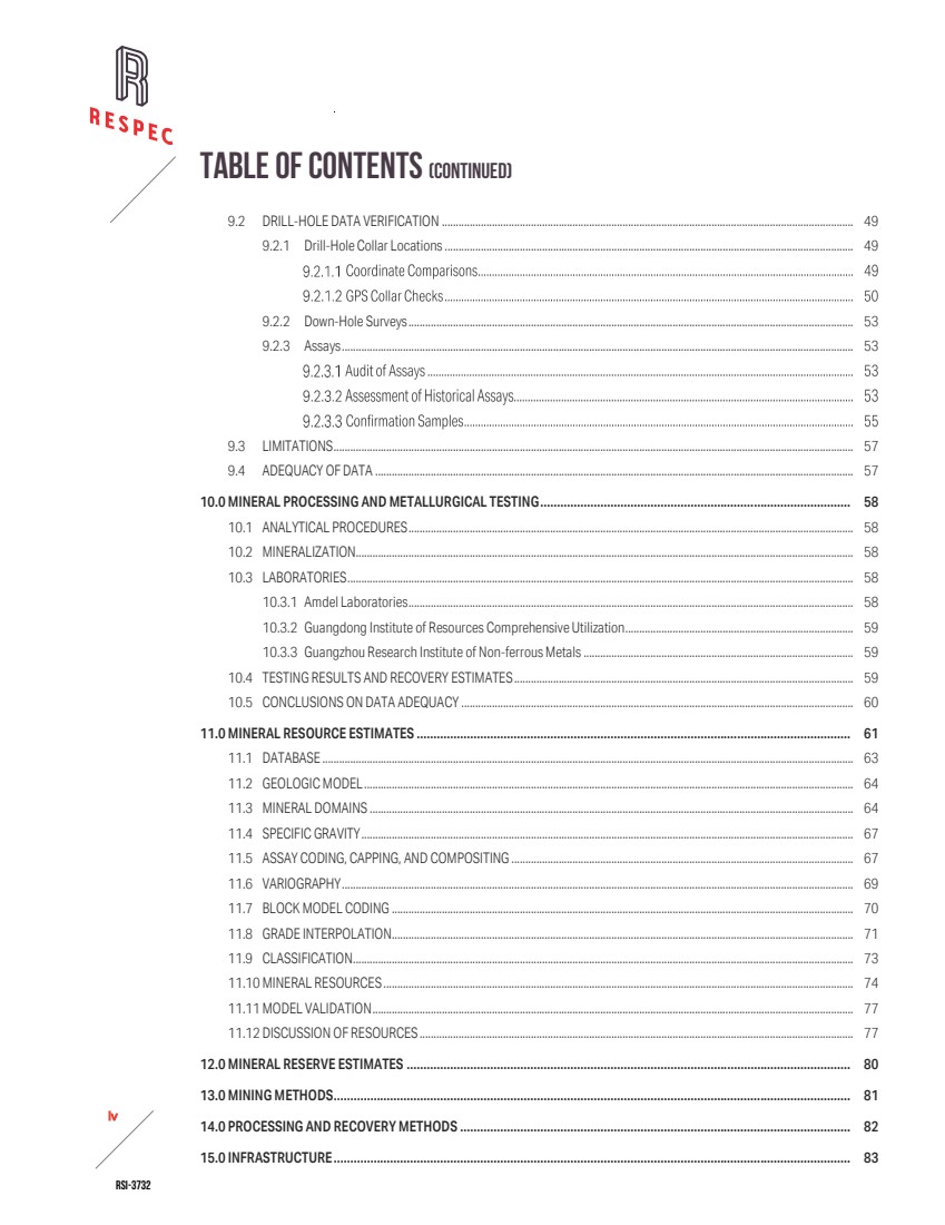
| RSI-3732 v 2 TABLE OF CONTENTS(CONTINUED) 16.0 MARKET STUDIES............................................................................................................................................................ 84 17.0 ENVIRONMENTAL STUDIES, PERMITTING, AND PLANS, NEGOTIATIONS, OR AGREEMENTS WITH LOCAL INDIVIDUALS OR GROUPS .............................................................................................................................................. 85 17.1 EXPLORATION PERMITTING REQUIREMENTS............................................................................................................................... 85 17.2 PERMITTING STATUS............................................................................................................................................................................ 85 17.3 BIOLOGICAL RESOURCES AND HABITAT SURVEYS..................................................................................................................... 85 17.4 CONCLUSIONS....................................................................................................................................................................................... 86 18.0 CAPITAL AND OPERATING COSTS.................................................................................................................................. 87 19.0 ECONOMIC ANALYSIS..................................................................................................................................................... 88 20.0 ADJACENT PROPERTIES................................................................................................................................................. 89 21.0 OTHER RELEVANT DATA AND INFORMATION............................................................................................................... 90 22.0 INTERPRETATION AND CONCLUSIONS ......................................................................................................................... 91 22.1 ADEQUACY OF THE DATA USED IN ESTIMATING THE PROJECT MINERAL RESOURCES.................................................. 91 22.2 EXPLORATION ........................................................................................................................................................................................ 92 22.3 GEOLOGY AND MINERALIZATION..................................................................................................................................................... 92 22.4 MINERAL RESOURCES ......................................................................................................................................................................... 92 23.0 RECOMMENDATIONS...................................................................................................................................................... 94 23.1 PHASE 1 RECOMMENDED ACTIVITIES AND BUDGET.................................................................................................................. 94 23.2 PHASE 2 RECOMMENDED ACTIVITIES AND BUDGET.................................................................................................................. 96 24.0 REFERENCES.................................................................................................................................................................... 98 25.0 RELIANCE ON INFORMATION PROVIDED BY THE REGISTRANT................................................................................... 100 APPENDIX A. LIST OF UNPATENTED LODE MINING CLAIMS OF THE PILOT MOUNTAIN TUNGSTEN PROJECT ................ A-1 |
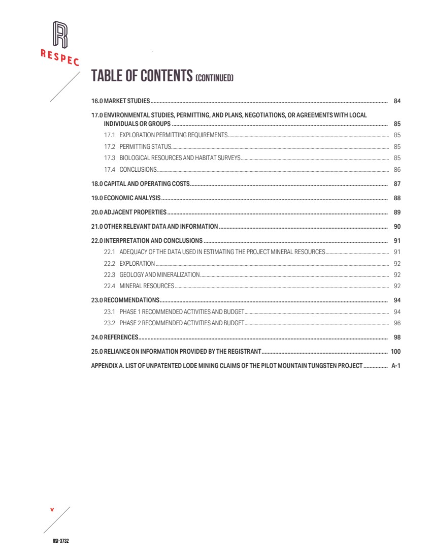
| RSI-3732 vi 2 LIST OF TABLES Table Page 1-1 Summary of Pilot Mountain Tungsten Project Drilling .......................................................................................................................... 5 1-2 Desert Scheelite Mineral Resources .......................................................................................................................................................... 6 1-3 Guardian Cost Estimate for Pilot Mountain Tungsten Project Recommended Work—Phase 1................................................. 8 1-4 Guardian Cost Estimate for Pilot Mountain Tungsten Project Recommended Work—Phase 2................................................. 9 3-1 Annual Holding Costs of the Pilot Mountain Project.............................................................................................................................. 18 5-1 Summary of Historical Drilling by Operator.............................................................................................................................................. 23 7-1 Guardian Drilling in 2024-2025.................................................................................................................................................................. 35 8-1 CRMs Used by Guardian Metals.................................................................................................................................................................. 41 8-2 Summary of Analyses for Guardian Certified Reference Materials 2024-2025............................................................................. 42 8-3 CRM Failures by Metal.................................................................................................................................................................................... 42 8-4 Summary of Results for Field Duplicates in 2024-2025....................................................................................................................... 43 8-5 Summary of Results for Preparation Duplicates in 2024–2025......................................................................................................... 46 8-6 Summary of Results for Pulp Duplicates in 2024-2025 ....................................................................................................................... 47 9-1 Positional Offset Statistics —WGS84 Versus NAD83 Coordinate Comparison.............................................................................. 50 9-2 Verification GPS Checks of Drill Collars at the Pilot Mountain Project.............................................................................................. 51 9-3: WO3 Population Statistics by Company......................................................................................................................................................... 54 9-4 Assay Results from Independent Confirmation Testing of Field Grab Samples.............................................................................. 56 11-1 Desert Scheelite Resource Database Descriptive Statistics—For All Accepted Sample Data Only.......................................... 64 11-2 Grade Ranges of Tungsten, Silver, Copper, and Zinc Domains Determined from CPPs............................................................... 64 11-3 Density Statistics and Values Applied to the Different Lithologies in the Block Model ................................................................ 67 11-4 Capping Levels for Tungsten, Silver, Copper, and Zinc by Domain ................................................................................................... 67 11-5 Tungsten Composite Descriptive Statistics ............................................................................................................................................. 68 11-6 Silver Composite Descriptive Statistics..................................................................................................................................................... 68 11-7 Copper Composite Descriptive Statistics................................................................................................................................................. 69 11-8 Zinc Composite Descriptive Statistics....................................................................................................................................................... 69 11-9 Variography by Metal Domain...................................................................................................................................................................... 70 11-10Search Ellipse Orientations .......................................................................................................................................................................... 71 11-11Desert Scheelite Estimation Parameters................................................................................................................................................... 72 11-12Pit Optimization Parameters......................................................................................................................................................................... 74 11-13Desert Scheelite Mineral Resources .......................................................................................................................................................... 75 23-1 Guardian Cost Estimate for Pilot Mountain Tungsten Project Recommended Work—Phase 1................................................. 95 23-2 Guardian Cost Estimate for Pilot Mountain Tungsten Project Recommended Work—Phase 2................................................. 97 |
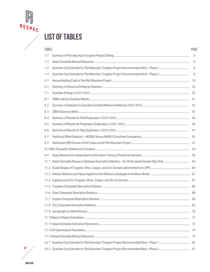
| RSI-3732 vii 2 LIST OF FIGURES FIGURE Page 3-1 Pilot Mountain Tungsten Project Location ............................................................................................................................................... 15 3-2 Pilot Mountain Tungsten Project Site Access Route.............................................................................................................................. 16 3-3 Pilot Mountain Map Showing Exterior Boundaries of the Land Package, Location of Deposits, and Boundary of the Platoro Royalty Area ................................................................................................................................................................................ 17 4-1 Desert Scheelite Test Pit in July 2025, Looking West, Showing Steeply Dipping Garnet Skarn (Brown) in Contact With Quartz Monzonite (White) .................................................................................................................................................................... 22 6-1 Property Geology of the Pilot Mountain Tungsten Project................................................................................................................... 28 6-2 North-South Cross-Section 424305E Showing Tungsten Mineral Domain and Geology........................................................... 29 6-3 Generalized Stratigraphic Column for the Pilot Mountain Tungsten Project .................................................................................. 30 7-1 Map of Drill Holes at the Pilot Mountain Project...................................................................................................................................... 36 8-1 Tungsten Field Duplicate vs. Original, Desert Scheelite 2024-2025................................................................................................ 44 8-2 Copper Field Duplicate vs. Original, Desert Scheelite 2024-2025.................................................................................................... 45 8-3 Zinc Field Duplicate vs. Original, Desert Scheelite 2024-2025.......................................................................................................... 45 8-4 Silver Field Duplicate vs. Original, Desert Scheelite 2024-2025 ....................................................................................................... 46 9-1 Box Plots of WO3 Data Sorted by Company.............................................................................................................................................. 54 9-2 Cumulative Probability Plots of WO3 Assays by Company—Guardian in Blue, Duval in Green, and UCC in Red ................... 55 11-1 North-South Cross-Section 424305E Showing Tungsten Mineral Domains and Geology......................................................... 66 11-2 North-South Cross-Section 424305E Showing WO3 Grades in the Block Model.......................................................................... 76 11-3 WO3 Bench Composite Grades versus Coincident Block Grades Interpolated by OK, ID2 , and NN........................................... 77 |
| RSI-3732 1 2 1.0 EXECUTIVE SUMMARY RESPEC has prepared this technical report on the Pilot Mountain Tungsten Project at the request of Guardian Metal Resources PLC. This technical report and the resource estimates have been prepared in accordance with the disclosure and reporting requirements outlined in the United States Securities and Exchange Commission’s (SEC) Modernized Property Disclosure Requirements for Mining Registrants as described in Subpart 229.1300 of Regulation S-K, Disclosure by Registrants Engaged in Mining Operations (S-K 1300) and Item 601 (b)(96) Technical Report Summary. RESPEC visited the Property on July 8-9, 2025. The costs are based on first quarter 2025 U.S. dollars. 1.1 PROPERTY DESCRIPTION AND OWNERSHIP The Pilot Mountain property is comprised of four skarn/tactite deposits—the Gunmetal, Garnet, Good Hope, and Desert Scheelite deposits—all located on the east side of Pilot Peak, about 39 kilometers (“km”) east of the small town of Mina, in Mineral County, Nevada. The property is centered at 38° 23’ 9” north latitude, 117° 52’ 26” west longitude and lies wholly within the historical Mina mining district. The Pilot Mountain Tungsten Project is comprised of 208 unpatented claims: 159 unpatented mining claims located by BFM Resources Inc., a wholly owned subsidiary of Guardian Metal Resources; four unpatented mill site claims also located by BFM Resources Inc.; and 45 unpatented mining claims owned by Pilot Metals Inc. that are known as the “NT claims.” Pilot Metals Inc. is also a wholly owned subsidiary of Guardian Metal Resources. The property comprises ~1,715 hectares (“ha”), all located on land administered by United States Bureau of Land Management (“BLM”). Ownership of unpatented mining claims is in the name of the holder (locator), subject to the paramount title of the United States of America, under the administration of the BLM. The holder has the right to explore, develop, and mine minerals on unpatented mining claims without payments of production royalties to the United States Government, subject to the surface management regulation of the BLM and all other applicable state and federal environmental regulations. Currently, annual federal claim maintenance fees and county recording fees totaling $44,108 are the only payments required to maintain unpatented mining claims. Those fees have been paid in full through September 1, 2026. Apex Royalties controls a royalty of 2% of the gross revenues from the production and sale of minerals from the 45 NT Claims, an area that totals ~611ha and encompasses the Gunmetal, Garnet, Good Hope, and Desert Scheelite deposits. The BLM requires permits for all significant surface disturbances. Geologic mapping, soil and rock sampling, and other low impact activities can be conducted without specific permits. Any road or trail construction used for mechanized equipment, drilling, or trenching requires filings with the BLM or county, as applicable. Up to five acres (~2ha) of disturbance are allowed on a notice-level filing. |
| RSI-3732 2 2 As is standard in Nevada, surface disturbances of more than five acres (~2has) require a plan of operation (“PoO”) approved by the BLM and Nevada Division of Environmental Protection, which in turn requires an Environmental Assessment (“EA”) or an Environmental Impact Statement done in accordance with the National Environmental Policy Act process. Guardian currently holds two Notices of Intent (“NOI”) for exploration activities: one for the Desert Scheelite area (NVNV 106362997) and one for Garnet (NVNV 106714287), which includes the northern portion of Gunmetal. These notices provide sufficient permit coverage to complete the recommended work outlines in Section 23.0. Guardian is also in the process of having an exploration PoO and EA reviewed by regulators. The authors are not aware of any factors that would limit Guardian’s ability to secure the necessary permits to complete the proposed work. Guardian does not yet hold a mining permit. The authors anticipate that most, if not all, of the exploration work proposed in Section 23.0 is permitted under the 2 notice-level filings with the respective agencies. Any expansion of the program to include large condemnation and resource expansion will likely require the approval of the EA and PoO for additional exploration activities at the site. If the exploration drilling will exceed the two five-acre (~2has) disturbance limit, Guardian will need the formal PoO to be accepted and approved by the regulating authorities. The authors are not aware of any factors that could limit Guardian’s ability to acquire the necessary permits to complete the proposed work. 1.2 ACCESSIBILITY, CLIMATE, LOCAL RESOURCES, INFRASTRUCTURE, AND PHYSIOGRAPHY The Pilot Mountain Tungsten Project is located in a sparsely populated area of gently rolling topography on the lower eastern slopes of the Pilot Mountains, northeast of Pilot Peak, in Mineral County, Nevada, approximately 260 road kilometers southeast of Reno, 146km southeast of Yerington, and 113km northwest of Tonopah via road. Elevations on the property ranges from ~1,830 meters (“m”) to ~2,290m above mean sea level in the central Basin and Range physiographic province of western Nevada. In general, the summers are hot and dry, and the winters are cold. Most precipitation falls during the winter and spring months. Neither exploration, mine construction, nor mine operations are likely to be significantly impacted by weather at seasonal extremes. Vegetation on the property is typical of the eastern Nevada high elevation desert, which largely consists of sagebrush, rabbit brush, small cacti, and bunch grass communities, consistent with a high-desert climate. Pinyon pine and juniper trees are present in some areas at higher elevations. Yerington, with a population of approximately 4,000, and Tonopah, with a population of approximately 1,900, serve as regional support hubs with an airport, well-developed infrastructure, and services that support the surrounding gold and silver mining and processing industry. The nearby towns of Yerington and Tonopah, along with Reno, can supply sufficient skilled labor for the project. 1.3 MINING AND EXPLORATION HISTORY The Pilot Mountain Tungsten Project area has been explored since scheelite was discovered on the east flank of the Pilot Mountains in 1916, resulting in a substantial body of geological, geophysical, and drilling data. Despite this history of exploration, only limited production has been recorded. |

| RSI-3732 3 2 Internal Union Carbide Corporation reports record production of 130 short tons from the Garnet Mine through 1943 and 15,378 short tons from the Gunmetal Mine in 1952-1956. Hecla Mining (“Hecla”) began drilling the Pilot Mountain property in 1968. In addition to Hecla, the historical operators Duval Corporation (“Duval"), W. R. Grace (“Grace"), and Union Carbide Corporation (“UCC”) have explored the property with drilling, geophysical surveys, and surface and underground sampling campaigns. UCC completed mining feasibility studies on the property and conducted trial mining on the Desert Scheelite deposit through a 70,000-tonne bulk sampling exercise. Low tungsten prices halted their activities. More recently, Black Fire Minerals Ltd. (“Black Fire”) optioned on the property in September 2011 and completed a 15-hole drilling program that supported the preparation of an initial mineral resource estimate for the Desert Scheelite deposit in 2012. Thor Mining PLC (“Thor”) acquired the property in 2014 and initiated a comprehensive exploration program targeting copper-silver mineralization within the Desert Scheelite and Garnet deposits. In total, the historical operators drilled 296 holes for a total of ~42,000m of drilling. Black Fire completed the first modern mineral resource estimate for the Desert Scheelite deposit, in 2012. Following additional drilling and project advancement, Thor Mining updated the resource estimate in 2018. Thor’s revised estimate reported 10.7 million tonnes at 0.26% WO₃, 19.4 g/t Ag, 0.15% Cu, and 0.38% Zn above a 0.15% WO₃ cut‑off, with the majority classified as indicated resources. The reader is cautioned not to treat this historical mineral resource estimate—or any part of it—as current mineral resources or mineral reserves. 1.4 GEOLOGICAL SETTING AND MINERALIZATION The Pilot Mountain property lies within the Walker Lane structural belt of western Nevada. The project area is underlain by a thick succession of Permian to Jurassic sedimentary and volcanic rocks locally intruded by Cretaceous granitic stocks, dykes, and sills and overlain around the margins by Tertiary volcanic units. The oldest unit exposed is the Permian Mina Formation, a thick accumulation of marine turbidites, chert, and volcanogenic tuffaceous strata, which is overlain by the Triassic Luning Formation, the principal host of mineralization on the property. The Luning is at least 2,300m thick in its type locality and is subdivided into lower, middle, and upper members. The lower Luning hosts mineralization at Desert Scheelite, and the upper Luning hosts mineralization in the Gunmetal–Garnet areas. Intrusion of a Jurassic biotite quartz monzonite stock produced contact metamorphism, converting adjacent carbonate rocks to marble and pelitic clastics to hornfels. During the latter phases of emplacement, metasomatic processes locally formed skarns and calc‑silicate alteration within marble and calcareous metaclastic units. Evidence of metamorphism extends up to 300m laterally from the northern contact of the stock, although the most extensive and economically interesting mineralization in the modeled resource area is largely confined to within ~90m of the contact. Tungsten mineralization is present within skarn (tactite) developed along limestone beds proximal to quartz monzonite intrusions. The Good Hope and Desert Scheelite deposits are subvertical and strike approximately east-west, while the Garnet and Gunmetal deposits are essentially flat lying. In addition to tungsten, the deposits contain variable amounts of copper, zinc and silver. The estimate of mineral resources presented in this report is for the Desert Scheelite deposit. |
| RSI-3732 4 2 1.5 EXPLORATION Since acquiring the Pilot Mountain Project in 2021, Guardian has advanced exploration through data review, updated geological modeling, geophysical surveys, rock‑chip sampling, and targeted drilling. Work has focused on validating the historical resource base, assessing extensions of known mineralization, and collecting samples to support metallurgical and geotechnical evaluations. These activities form the basis for ongoing technical studies and a planned pre‑feasibility assessment. Initial hydrological or geotechnical investigations have commenced and are ongoing. 1.5.1 ROCK CHIP SAMPLING Guardian collected 12 quartz monzonite samples and nine altered wall‑rock samples in 2024, confirming geochemical ratios (Sr/Y>80; La/Yb>20; Yb<1.5; Eu anomalies>0.9) consistent with porphyry Cu‑Mo systems. Copper assays south of Porphyry South returned up to 799ppm Cu and 201ppm Mo. In 2025, 189 additional samples were collected; results confirmed elevated Cu and Mo across Porphyry South, including 15 samples >1,000ppm Cu along a ~1km ridge, with a maximum of 2.05% Cu. Petrography identified cuprite, malachite, and tenorite. Trace element geochemistry was consistent with QSP alteration and indicative of the phyllic zone, which commonly surrounds porphyry system cores. 1.5.2 GEOPHYSICAL SURVEYS A high‑resolution IP survey in 2023 delineated three chargeability anomalies interpreted as disseminated sulfide mineralization. In 2025, Guardian extended coverage with a 3DIP survey, confirming anomalies south of the initial grid. These results provide early evidence of porphyry‑style systems and support refinement of drill targets. 1.5.3 DRILLING Guardian has completed 89 diamond core holes: 68 at Desert Scheelite, 20 at Garnet, and one at Porphyry South. Drilling was conducted by Diamondback Drilling using Boart Longyear LF Super 90 rigs, with core recovery improving as programs advanced. All collar locations were surveyed in UTM coordinates (WGS84 datum) by ASPS, and down‑hole surveys were collected at 10m intervals using Gyromaster instrumentation. 1.6 DRILLING The Pilot Mountain database contains 385 drill holes totaling 52,417 meters of drilling. Several drilling campaigns and operators span the contents of the database. Based on the author’s current knowledge, historical operators of the campaigns include Union Carbide which drilled 185 drill-holes totaling 23,234 meters. Guardian Metal Resources drilled 89 drill-holes totaling 10,344 meters. Drilling is concentrated in and around the Desert Scheelite area. |
| RSI-3732 5 2 Table 1-1 is a breakdown of the drilling and operators in the Pilot Mountain Tungsten Project area. Table 1-1. Summary of Pilot Mountain Tungsten Project Drilling Drilling Program Drilling Dates No. DHs Length (m) Length (ft) Historic Operators 1968–2017 296 42,073 138,035 Guardian Metal Resources 2024–2025 89 10,344 33,937 Total 385 52,417 171,972 Drilling sampling procedures provided representative samples of sufficient quality for use in the resource estimation discussed in Section 14.0. The QP is unaware of any sampling and recovery factors that will materially impact the mineral resources discussed in Section 14.0. 1.7 METALLURGICAL TESTING AND MINERAL PROCESSING RESPEC summarizes metallurgical test work completed on the Desert Scheelite deposit for informational purposes only and offers no independent conclusions. Amdel Laboratories confirmed scheelite as the sole tungsten‑bearing mineral and conducted liberation studies that established a target grind size of 106µm. Gravity separation using Wilfley tabling followed by Mozley cleaning achieved an upgrade ratio of approximately 27:1, recovering 72.5% of contained tungsten to 1.7% of the feed mass. Subsequent rougher flotation tests performed at grind sizes of P80 106µm and P80 45µm, including a conceptual circuit that recycled gravity middlings and tails, achieved recoveries of up to 90.7% WO₃, although concentrate grades were limited by calcium gangue carryover. The Guangdong Institute conducted rougher flotation at approximately 70% passing 75µm, producing rougher concentrates grading 3.92% WO₃ at 76.1% recovery. Multi‑stage heated cleaning yielded final scheelite concentrates grading between 66.9% and 68.2% WO₃ at recoveries of 71–74%, with impurity levels meeting commercial specifications. Guangzhou Research Institute of Non-ferrous Metals reviewed and corroborated the gravity plus flotation process concept and recommended reagent optimization, cleaner circuit configuration, and potential recovery of additional tungsten from magnetic products by spirals or tabling. Samuel Engineering [Samuel, 2025] concluded that the metallurgical test work completed to date provides a reasonable preliminary understanding of the mineralogy and process response of the Desert Scheelite deposit. Samuel recommended additional variability testing, reagent optimization, and confirmatory work on domain‑specific composites to validate recovery factors and establish robust process parameters for future resource and reserve estimation stages. 1.8 MINERAL RESOURCE ESTIMATE At Desert Scheelite, Guardian’s geologic model is well defined with distinctive rock units and forms the principal control for the metal domain modelling and resource estimation. RESPEC interpreted a tungsten mineral domain for Desert Scheelite to estimate tungsten trioxide, silver, copper, and zinc. Separate interpolations were run with ordinary kriging, inverse distance, and nearest neighbor for each metal. The kriged interpolation is reported in Table 1-2. The Desert Scheelite mineral resources have |
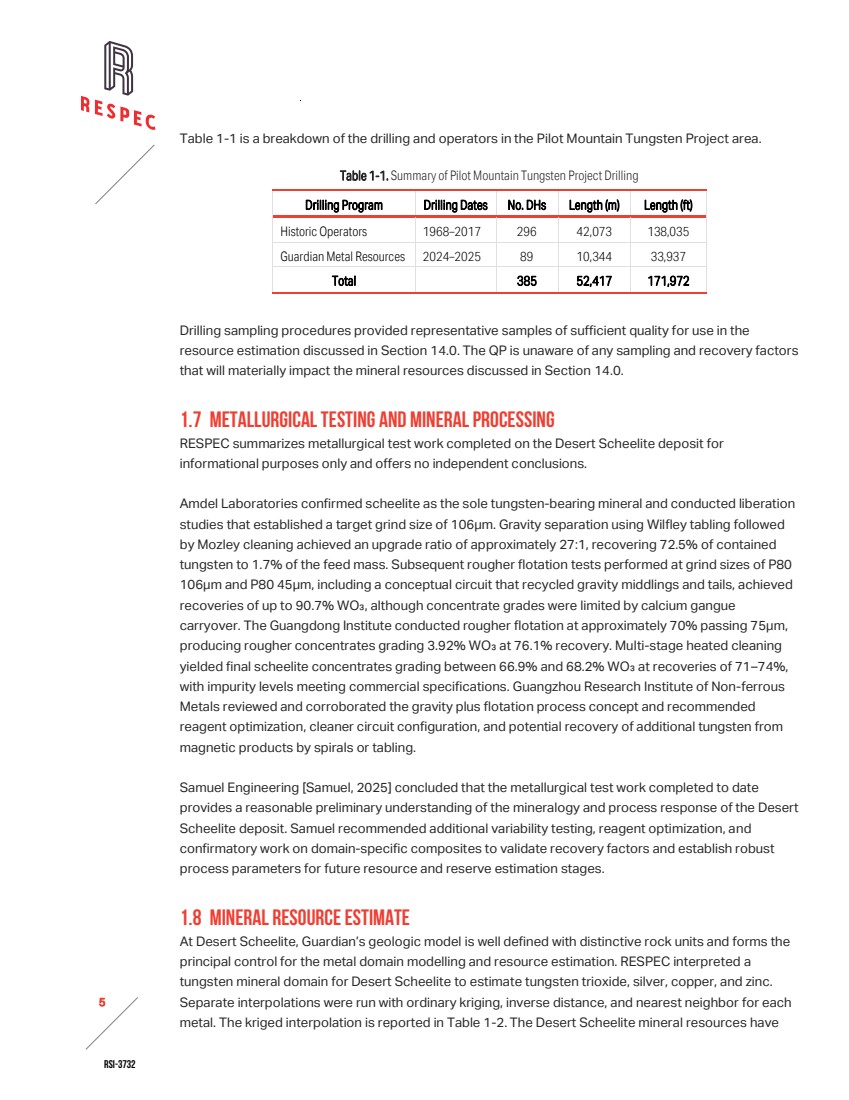
| RSI-3732 6 2 been estimated to reflect potential open-pit extraction and processing by standard flotation and milling techniques. Resources were reported at a 0.06% WO3 cut-off. Silver, copper, and zinc are reported within the mineral resources using the WO3 cut-off grade. No independent cut-off grades were applied to silver, copper, or zinc. Those metals are considered by-products contingent upon economic extraction of WO3. RESPEC has classified Desert Scheelite mineral resources in accordance with the definitions for mineral resources in S-K 1300. Table 1-2. Desert Scheelite Mineral Resources Cut-off Average Grade Contained Metal Classification % WO3 Tonnes % WO3 g Ag/t % Cu % Zn t WO3 oz Ag t Cu t Zn Indicated 0.06 8,694,000 0.206 12.43 0.085 0.315 17,900 3,475,000 7,400 27,400 Inferred 0.06 1,784,000 0.169 12.00 0.063 0.225 3,000 689,000 1,100 4,000 Notes: 1. The effective date of Desert Scheelite mineral resources is December 1, 2025. 2. The estimate of mineral resources was done by RESPEC in metric tonnes. 3. The point of reference is in situ mineralization prior to extraction by open pit mining methods. 4. The average grades of the tabulations are comprised of the weighted average of block-diluted grades within an optimized pit. 5. The Desert Scheelite mineral resource cut‑off grade of 0.06% WO₃ was selected by the authors. Operating assumptions were applied to establish a theoretical pit limit, including a WO₃ price of $65,500/t, an average recovery of 80% WO₃, a processing rate of 4,000 tonnes/day, $2.75/t mining cost for open pit, $15.64/t processing cost, $3.00/t processed for G&A, and an 83% payability. Blocks outside the pit limit are considered not economic at this time. 6. The accessory metals Ag, Cu, and Zn shown in Table 11-13 are the quantities contained within the mineral resources using the cut-off grade established for the primary commodity (WO3). No independent cut-off grade has been applied to these accessory metals. Reported quantities of accessory metals are therefore considered by-products of the primary metal resource and their value is contingent upon the ability to economically extract the by-products along with the primary commodity. 7. The estimate of mineral resources may be materially affected by geology, environmental, permitting, legal, title, taxation, sociopolitical, marketing, or other relevant issues. 8. Rounding as required by reporting guidelines may result in apparent discrepancies between tonnes, grade, and contained metal content. 9. Mineral resources are not mineral reserves and do not have demonstrated economic viability. An inferred mineral resource has a lower level of confidence than an indicated mineral resource and must not be converted to a mineral reserve. RESPEC reasonably expects that continued exploration and delineation will upgrade the majority of inferred mineral resources to indicated mineral resources. 1.9 INTERPRETATIONS AND CONCLUSIONS RESPEC offers the following conclusions and observations by area: 1.9.1 ADEQUACY OF THE DATA USED IN ESTIMATING MINERAL RESOURCES RESPEC’s audit confirmed that the Desert Scheelite database is adequate for mineral resource estimation and disclosure under S‑K 1300. Guardian’s 2024–2025 drilling program was conducted to current industry standards and provides a reliable foundation for the resource model. Historical datasets were integrated with appropriate caution, and while some risk persists in the estimated volume of higher‑grade material, the database is considered suitable for technical reporting, resource estimation, and regulatory compliance. |
| RSI-3732 7 2 RESPEC determined that Guardian’s sampling, core handling, and chain‑of‑custody procedures are adequate to support the resource estimate. ALS performed sample preparation and analysis using appropriate multi‑element and ore‑grade methods, including re‑assay of overlimit values. Guardian’s QA/QC program incorporated certified reference materials, blanks, and duplicates at acceptable frequencies, and statistical evaluation confirmed precision and minimal bias for tungsten, copper, and zinc. Silver assays showed slightly elevated variability at low concentrations but no systematic errors. Overall QA/QC results are adequate, though documentation of follow‑up on isolated failures is incomplete. Confidence in historical drilling remains lower due to absent QA/QC records and limited documentation of sampling protocols. Comparative analysis demonstrated broadly consistent grade distributions across datasets, with interpolation tests indicating historical WO₃ grades approximately 17% higher than Guardian’s, attributed to sampling population effects and drilling geometry. Guardian’s angled drilling reduced geometric bias, and corroborating evidence supports selective inclusion of historical colorimetric assays. The modern dataset provides confidence in the overall resource model, with estimation risk primarily linked to legacy data. 1.9.2 GEOLOGY AND MINERAL RESOURCES The Pilot Mountain Tungsten Project lies within the Walker Lane structural belt of western Nevada, where strike‑slip faulting, extensional basins, and magmatism have strongly influenced mineralization. Mineralization is hosted by the Triassic Luning Formation, subdivided into lower, middle, and upper members, and intruded by Jurassic to Cretaceous granitic stocks. The Desert Scheelite deposit is a tungsten skarn formed along the contact of quartz monzonite intrusions with lower Luning carbonates and biotite hornfels. Scheelite is the dominant ore mineral, accompanied by pyrite, chalcopyrite, and sphalerite, with local base‑metal sulfide contents exceeding 20% in unoxidized samples. The Desert Scheelite mineral resources extend approximately 600m along strike and at least 300m down dip. Mineralization is sub‑vertical and includes three higher‑grade tungsten zones that reflect structural and lithological controls. Guardian’s drilling and geologic modeling improved understanding of mineralization continuity and provided the basis for tungsten domain modeling and resource estimation. RESPEC estimated resources assuming potential open‑pit extraction with standard milling and flotation techniques, optimizing pits at variable WO₃ prices using Nevada‑based cost assumptions. Resources are reported at a 0.06% WO₃ cut‑off grade, with silver, copper, and zinc included as by‑products contingent on WO₃ extraction. A majority of resources (83%) are classified as indicated, supported by Guardian’s drilling density, QA/QC data, and improved geologic understanding. Uncertainties remain due to limitations in historical datasets, including incomplete survey records, inconsistent assay documentation, selective sampling, and the predominance of vertical holes in steeply dipping zones, which may have exaggerated higher‑grade thicknesses. Guardian’s angled drilling reduced geometric bias, but some risk persists in the estimated volume of higher‑grade material. |
| RSI-3732 8 2 1.10 RECOMMENDATIONS 1.10.1 PHASE 1 RESPEC recommends that Guardian focus on reducing estimation risk, validating historical data, and advancing Desert Scheelite toward feasibility evaluation. / Drilling & Assay Programs: 1,500m of core drilling at Desert Scheelite to increase drill density and confidence, with twin holes to validate historical assays. Additional 1,800m each at Garnet and Gunmetal, plus 2,000m of exploration drilling across Pilot Mountain. QA/QC protocols (CRMs, blanks, duplicates) and follow‑ups with ALS are advised. / Petrological & Metallurgical Studies: Detailed mineralogical and ore characterization integrated with metallurgical test work to refine WO₃ recovery, flotation efficiency, and by‑product performance. / Geologic Modeling & Reporting: Updates to lithologic, alteration, and structural models to improve block model reliability; material changes to be reported under S‑K 1300. / Hydrology, Permitting & Bonding: Continuation of hydrogeological baseline studies, initiation of pit dewatering assessments, and parallel permitting/bonding activities. / Support Infrastructure: Securing labor, equipment, and materials to sustain drilling, analytical, and study programs. Table 1-3. Guardian Cost Estimate for Pilot Mountain Tungsten Project Recommended Work—Phase 1 Task Qty Unit US$ per unit US$ Desert Scheelite Core Drilling 1,500 meter $520 $780,000 Garnet Core Drilling 1,800 meter $520 $936,000 Gunmetal Core Drilling 1,800 meter $520 $936,000 Exploration Core Drilling 2,000 meter $520 $1,040,000 Assays 4,700 samples $55 $260,000 Metallurgical Test Work $450,000 Geological Modelling $25,000 Hydrology Study $675,000 Ore Characterization Study $525,000 Permitting and Bonding $645,000 Pre-Feasibility Study $1,620,000 Reporting $220,000 Labor / Support Staff $2,370,000 Equipment and Materials $70,000 Total $10,552,000 |

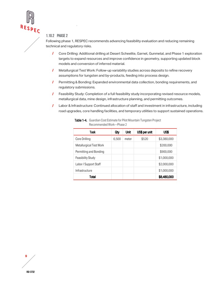
| RSI-3732 9 2 1.10.2 PHASE 2 Following phase 1, RESPEC recommends advancing feasibility evaluation and reducing remaining technical and regulatory risks. / Core Drilling: Additional drilling at Desert Scheelite, Garnet, Gunmetal, and Phase 1 exploration targets to expand resources and improve confidence in geometry, supporting updated block models and conversion of inferred material. / Metallurgical Test Work: Follow‑up variability studies across deposits to refine recovery assumptions for tungsten and by‑products, feeding into process design. / Permitting & Bonding: Expanded environmental data collection, bonding requirements, and regulatory submissions. / Feasibility Study: Completion of a full feasibility study incorporating revised resource models, metallurgical data, mine design, infrastructure planning, and permitting outcomes. / Labor & Infrastructure: Continued allocation of staff and investment in infrastructure, including road upgrades, core handling facilities, and temporary utilities to support sustained operations. Table 1-4. Guardian Cost Estimate for Pilot Mountain Tungsten Project Recommended Work—Phase 2 Task Qty Unit US$ per unit US$ Core Drilling 6,500 meter $520 $3,380,000 Metallurgical Test Work $200,000 Permitting and Bonding $900,000 Feasibility Study $1,000,000 Labor / Support Staff $2,000,000 Infrastructure $1,000,000 Total $8,480,000 |
| RSI-3732 10 2 2.0 INTRODUCTION RESPEC Company LLC (“RESPEC”) has prepared this independent technical report summary on the Pilot Mountain Tungsten Project, located in Mineral County, Nevada, at the request of Guardian Metal Resources PLC. (“Guardian”), a United Kingdom company based in London that is listed on the London Stock Exchange (LON:GMET) and trading over-the-counter (OTCQX: GMTLF). Guardian holds and operates the Pilot Mountain property through a series of ownership transitions, culminating in its acquisition by Guardian in 2021. This report has been prepared in accordance with the disclosure and reporting requirements outlined in the United States Securities and Exchange Commission’s (“SEC”) Modernized Property Disclosure Requirements for Mining Registrants as described in Subpart 229.1300 of Regulation S-K, Disclosure by Registrants Engaged in Mining Operations (“S-K 1300”) and Item 601 (b)(96) Technical Report Summary. 2.1 PROJECT SCOPE AND TERMS OF REFERENCE The purpose of this document is to provide a technical report summary of the Pilot Mountain Tungsten Project, including an updated, current estimate of the tungsten mineral resources, in support of securities regulatory reporting requirements. The Pilot Mountain property lies within the historical Mina mining district of west-central Nevada. Exploration work, data, results, and all other matters, including land tenure, legal obligations, and environmental permitting from 2021 through the effective date of this report are attributed to Guardian. In the last 45 years, several technical resource reports have been prepared for Pilot Mountain resources areas, although none of them were S-K 1300 compliant. In May 1981, Kaiser Engineers prepared the report Feasibility Study for Mining and Concentrating of Pilot Mountain Tungsten Ore, Mineral County, Nevada on behalf of Union Carbide Corporation Metals Division. In August 2012, Golder Associates Pty Ltd, prepared Desert Scheelite Resource with Final Report Number 127641013-002-R-Rev0. In August 2018, Andrew Vidale Consulting Services prepared Pilot Mountain Mining Scoping Study on behalf of Thor Mining PLC (“Thor”). In November 2018, Resource Evaluation Services (“RES”) updated the mineral resource estimate for the Desert Scheelite area on behalf of Thor. Guardian acquired the property in 2021 and carried out various exploration activities and further drilling of 10,344 meters. This report updates and replaces Resource Evaluation Services’ mineral resource estimate (2018) prepared on behalf of Thor. RESPEC conducted the estimation and classification of the current mineral resources presented in Section 11.0. As the Qualified Person (“QP”) under S-K 1300, RESPEC confirms that the estimated mineral resources presented herein were calculated in accordance with the standards and requirements of the regulation. RESPEC has no affiliations with Guardian other than its role as an independent consultant. The scope of this study included a review of pertinent technical reports and data that Guardian provided to RESPEC about the Pilot Mountain Tungsten Project’s general setting, geology, project history, exploration activities and results, methodology, quality assurance, interpretations, drilling programs, and metallurgy. This report is based on data and information derived from work done by |

| RSI-3732 11 2 historical operators and Guardian. RESPEC has reviewed much of the available data, visited the project site, and has made judgments about the general reliability of the underlying data. Where data was deemed inadequate or unreliable, they either excluded it from consideration or adjusted and considered it appropriately. RESPEC has made such independent investigations as deemed necessary in their professional judgment to allow them to reasonably present the conclusions, interpretations, and recommendations of this report. RESPEC visited the Pilot Mountain Tungsten Project from July 8 through July 9, 2025. During their site visit, they inspected sampling procedures at an active core drill site and reviewed Guardian’s logging and QA/QC insertion procedures, geological cross sections, mineralized drill core, and examined outcrops that represented the local geology. The effective date of this technical report summary is December 15, 2025. 2.2 RELIANCE ON OTHER EXPERTS RESPEC is not an expert in legal matters, such as the assessment of the validity of mining claims, mineral rights, royalties, and property agreements in the United States or elsewhere. Furthermore, RESPEC did not conduct any investigations of the environmental, social, or political issues associated with the Pilot Mountain Tungsten Project, nor are they experts in these matters. Therefore, RESPEC has therefore relied entirely upon information and opinions provided by Guardian with regard to the following: / Guardian’s land tenure as presented in Section 3.2. The authors have relied entirely on a mineral title opinion and additional documentation provided by Guardian to confirm the legal ownership status of patented and unpatented claims within the Property. The opinion, Mineral Title Opinion, is explained in Section 3.2. / The legal agreements, royalties, and encumbrances that pertain to Guardian’s land package that are presented in sections 3.6 and 3.4. / The environmental liabilities presented in Section 3.5. / Metallurgical results relied upon in this report are outlined in Section 10.0. / The environmental baseline studies presented in Section 17.0. 2.3 FREQUENTLY USED ACRONYMS, ABBREVIATIONS, DEFINITIONS, AND UNITS OF MEASURE In this report, measurements are generally reported in metric units. Where information was originally reported in Imperial units, the author has made the conversions as shown below. Currency, units of measure, and conversion factors used in this report include: Linear Measure 1 centimeter = 0.3937 inch 1 meter = 3.2808 feet = 1.0936 yard 1 kilometer = 0.6214 mile |

| RSI-3732 12 2 Area Measure 1 hectare = 2.471 acres = 0.0039 square mile Capacity Measure (liquid) 1 liter = 0.2642 US gallons Weight 1 tonne = 1.1023 short tons = 2,205 pounds 1 kilogram = 2.205 pounds Currency: All references to dollars ($) in this report refer to the currency of the United States. Frequently used acronyms and abbreviations 3DIP three-dimensional induced polarization % percent AA atomic absorption spectrometry AES atomic emission spectroscopy Ag silver Amdel Amdel Laboratories of Perth, Australia ASPS Advanced Surveying & Professional Services ASL above sea level Au gold AuEq gold equivalent Black Fire Black Fire Minerals Ltd. BLM US Department of the Interior, Bureau of Land Management BMRR Bureau of Mining Regulation and Reclamation CDN CDN Resource Laboratories Ltd. cm centimeters CNAS China National Accreditation Service CoG cutoff grade core diamond-core drilling method CPP cumulative probability plot oC degrees Centigrade °F degrees Fahrenheit Duval Duval Corporation EA environmental assessment EIS environmental impact statement FA fire assay ft foot or feet Geostats Geostats Pty Ltd. Grace W. R. Grace g/t grams per tonne g Ag/t grams silver per tonne g Au/t grams gold per tonne GMR Guardian Metals Resources PLC Guangdong Institute Guangdong Institute of Resources Comprehensive Utilization Guardian Guardian Metals Resources PLC GZRINM Guangzhou Research Institute of Non-ferrous Metals ha hectare |
| RSI-3732 13 2 Hecla Hecla Mining Company ICP inductively coupled plasma analytical method ID2 inverse distance squared estimation in. inch or inches IP induced polarization keV kilo-electron volt kg kilograms km kilometers kW kilowatt l liter lbs pounds µm micron or microns, micrometer, or micrometers m meters Ma million years old max. maximum mGal milligal mi mile or miles min. minimum mm millimeters MW megawatt NDEP Nevada Department of Environmental Protection NN nearest neighbor estimation NSR net smelter return OK ordinary kriging opt ounce per ton oz ounce PoO Plan of Operation ppm parts per million ppb parts per billion QA/QC quality assurance and quality control QP qualified person RC reverse circulation drilling method RESPEC the RESPEC Company LLC RQD rock quality designation Samuel Samuel Engineering SEC United States Securities and Exchange Commission SG specific gravity t metric tonne or tonnes Thor Thor Mining PLC Thor Mining Thor Mining PLC ton Imperial short ton tpd tonnes per day UCC Union Carbide Corporation UTM Universal Transverse Mercator US United States USFS United States Forest Service USGS United States Geological Survey |
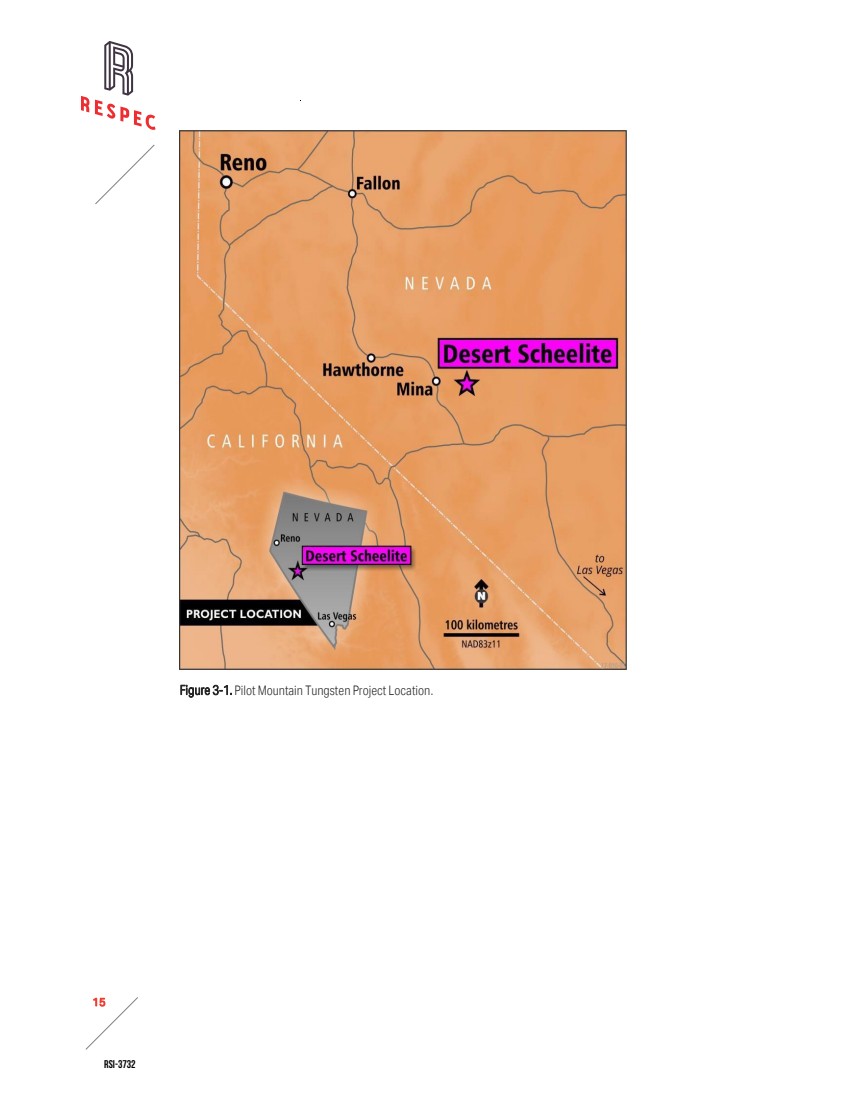
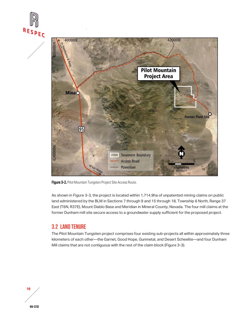
| RSI-3732 14 2 3.0 PROPERTY DESCRIPTION RESPEC is not an expert with regards to land, legal, environmental, social, and permitting matters. For the information presented in this section, they relied entirely on data provided by Guardian Metal Resources and on a report provided by the legal firm of Erwin Thompson Faillers dated July 22, 2025, that describes the record title and status of the unpatented mining claims which are controlled by Guardian Metal Resources and BFM Resources, Inc., a Nevada corporation that is a wholly-owned subsidiary of Guardian Metal Resources. RESPEC has reviewed the information provided by Guardian and Erwin Thompson Faillers and considers the third-party data suitable for use in this Technical Report Summary. The list of claims referenced in Erwin Thompson Faillers’ record title and status report is presented in Appendix A. RESPEC is not aware of any significant factors and/or risks beyond those described in this report that affect access, title, or the right or ability to perform work on the property. 3.1 LOCATION As shown in Figure 3-1, the Pilot Mountain Tungsten Project’s property is located on the east side of the Pilot Mountains in west-central Nevada, centered at 38°23’9”N, 117°52’26”W. The closest town is Mina, Nevada, located about 19 air kilometers due west of the property, or about 39km via a well-graded gravel road (Figure 3-2). The closest larger town—Hawthorne, Nevada—is located about 68 air kilometers west-northwest of the property. |
| RSI-3732 15 2 Figure 3-1. Pilot Mountain Tungsten Project Location. |
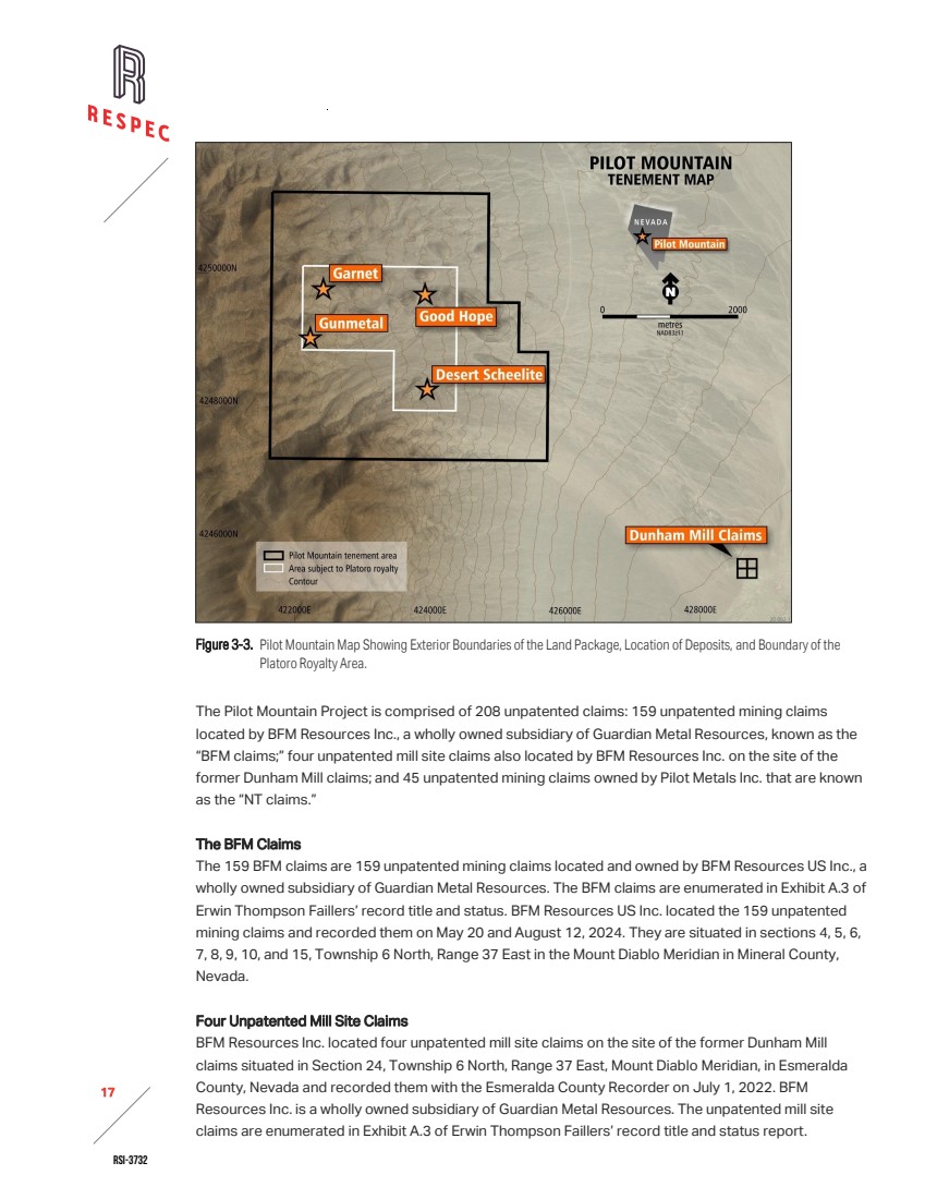
| RSI-3732 16 2 Figure 3-2. Pilot Mountain Tungsten Project Site Access Route. As shown in Figure 3-3, the project is located within 1,714.9ha of unpatented mining claims on public land administered by the BLM in Sections 7 through 9 and 15 through 18, Township 6 North, Range 37 East (T6N, R37E), Mount Diablo Base and Meridian in Mineral County, Nevada. The four mill claims at the former Dunham mill site secure access to a groundwater supply sufficient for the proposed project. 3.2 LAND TENURE The Pilot Mountain Tungsten project comprises four existing sub-projects all within approximately three kilometers of each other—the Garnet, Good Hope, Gunmetal, and Desert Scheelite—and four Dunham Mill claims that are not contiguous with the rest of the claim block (Figure 3-3). |
| RSI-3732 17 2 Figure 3-3. Pilot Mountain Map Showing Exterior Boundaries of the Land Package, Location of Deposits, and Boundary of the Platoro Royalty Area. The Pilot Mountain Project is comprised of 208 unpatented claims: 159 unpatented mining claims located by BFM Resources Inc., a wholly owned subsidiary of Guardian Metal Resources, known as the “BFM claims;” four unpatented mill site claims also located by BFM Resources Inc. on the site of the former Dunham Mill claims; and 45 unpatented mining claims owned by Pilot Metals Inc. that are known as the “NT claims.” The BFM Claims The 159 BFM claims are 159 unpatented mining claims located and owned by BFM Resources US Inc., a wholly owned subsidiary of Guardian Metal Resources. The BFM claims are enumerated in Exhibit A.3 of Erwin Thompson Faillers’ record title and status. BFM Resources US Inc. located the 159 unpatented mining claims and recorded them on May 20 and August 12, 2024. They are situated in sections 4, 5, 6, 7, 8, 9, 10, and 15, Township 6 North, Range 37 East in the Mount Diablo Meridian in Mineral County, Nevada. Four Unpatented Mill Site Claims BFM Resources Inc. located four unpatented mill site claims on the site of the former Dunham Mill claims situated in Section 24, Township 6 North, Range 37 East, Mount Diablo Meridian, in Esmeralda County, Nevada and recorded them with the Esmeralda County Recorder on July 1, 2022. BFM Resources Inc. is a wholly owned subsidiary of Guardian Metal Resources. The unpatented mill site claims are enumerated in Exhibit A.3 of Erwin Thompson Faillers’ record title and status report. |
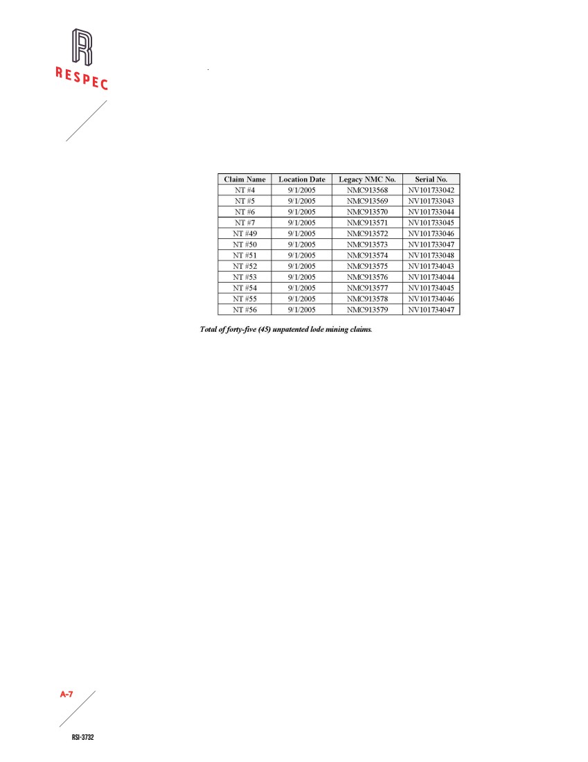
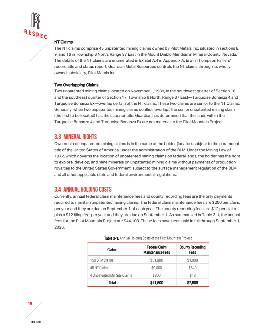
| RSI-3732 18 2 NT Claims The NT claims comprise 45 unpatented mining claims owned by Pilot Metals Inc. situated in sections 8, 9, and 16 in Township 6 North, Range 37 East in the Mount Diablo Meridian in Mineral County, Nevada. The details of the NT claims are enumerated in Exhibit A.4 in Appendix A, Erwin Thompson Faillers’ record title and status report. Guardian Metal Resources controls the NT claims through its wholly owned subsidiary, Pilot Metals Inc. Two Overlapping Claims Two unpatented mining claims located on November 1, 1989, in the southwest quarter of Section 16 and the southeast quarter of Section 17, Township 6 North, Range 37 East—Turquoise Bonanza 4 and Turquoise Bonanza Ex—overlap certain of the NT claims. These two claims are senior to the NT Claims. Generally, when two unpatented mining claims conflict (overlap), the senior unpatented mining claim (the first to be located) has the superior title. Guardian has determined that the lands within the Turquoise Bonanza 4 and Turquoise Bonanza Ex are not material to the Pilot Mountain Project. 3.3 MINERAL RIGHTS Ownership of unpatented mining claims is in the name of the holder (locator), subject to the paramount title of the United States of America, under the administration of the BLM. Under the Mining Law of 1872, which governs the location of unpatented mining claims on federal lands, the holder has the right to explore, develop, and mine minerals on unpatented mining claims without payments of production royalties to the United States Government, subject to the surface management regulation of the BLM and all other applicable state and federal environmental regulations. 3.4 ANNUAL HOLDING COSTS Currently, annual federal claim maintenance fees and county recording fees are the only payments required to maintain unpatented mining claims. The federal claim maintenance fees are $200 per claim, per year and they are due on September 1 of each year. The county recording fees are $12 per claim plus a $12 filing fee, per year and they are due on September 1. As summarized in Table 3-1, the annual fees for the Pilot Mountain Project are $44,108. These fees have been paid in full through September 1, 2026. Table 3-1. Annual Holding Costs of the Pilot Mountain Project Claims Federal Claim Maintenance Fees County Recording Fees 159 BFM Claims $31,800 $1,908 45 NT Claims $9,000 $540 4 Unpatented Mill Site Claims $800 $48 Total $41,600 $2,508 |
| RSI-3732 19 2 3.5 ROYALTIES 3.5.1 PILOT MOUNTAIN PROJECT ROYALTIES BFM Claims and Mill Site Claims There are no royalties associated with the 159 BFM claims and the four unpatented mill site claims. NT Claims Apex Royalties controls a royalty of 2% of the gross revenues from the production and sale of minerals from the 45 NT Claims. 3.6 ENCUMBRANCES The Pilot Mountain Project is located on federal lands administered by the BLM, and the BLM requires permits for all significant surface disturbances. Geologic mapping, soil and rock sampling, and other low impact activities can be conducted without specific permits on a casual use basis. Any road or trail construction used for mechanized equipment, drilling, or trenching requires filings with the BLM or county, as applicable. Up to five acres (~2ha) of disturbance are allowed on a notice-level filing. The notice-level filing may come with restrictions to protect biological, historical, or archeological resources. For lands administered by the BLM, a performance bond is required to ensure completion of the required reclamation work. Disturbances of more than five acres (~2has) requires a Plan of Operation (“PoO”) approved by the BLM and Nevada Division of Environmental Protection (“NDEP”), which in turn requires an Environmental Assessment (“EA”) or an Environmental Impact Statement (“EIS”) through the National Environmental Policy Act (“NEPA”) process. This process is standard practice in Nevada. Regulators and applicants follow a standard set of rules. A PoO may require significant environmental and archeological assessment work before the permit can be issued. Lead times for a PoO can take up to a year or two depending on the environmental conditions and extent of proposed operations. Guardian currently holds two Notices of Intent (NOIs) for exploration activities: one for the Desert Scheelite area (NVNV‑106362997) and one for Garnet (NVNV‑106714287), which includes the northern portion of Gunmetal. These notices provide sufficient permit coverage to complete the recommended work outlines in Section 23.0. Guardian is also in the process of having an exploration PoO and EA reviewed by regulators. The authors are not aware of any factors that would limit Guardian’s ability to secure the necessary permits to complete the proposed work. Guardian does not yet hold a mining permit. 3.7 OTHER SIGNIFICANT FACTORS AND RISKS / Guardian is not aware of any significant environmental, social, or permitting issues that would prevent continued exploitation of the Pilot Mountain Tungsten deposits. / Guardian is not aware of any other significant factors and risks that may affect access, title, or the right or ability to perform the proposed work program on the Property. / Information provided by Guardian and Erwin Thompson Faillers’ record title and status report supports that the mining tenure held by Guardian is valid and is sufficient to support the declaration of mineral resources. |
| RSI-3732 20 2 / Guardian holds sufficient surface rights in the project area to support the mining operations, including access. Power supply for site operations will require generators, with connection to grid power under investigation as part of ongoing engineering studies. Establishing grid access will require a power line easement to secure rights‑of‑way for transmission infrastructure. 3.7.1 RIGHTS-OF-WAY Guardian is not aware of any rights‑of‑way that would encumber exploration activities or the potential development of a mining project. |

| RSI-3732 21 2 4.0 ACCESSIBILITY, CLIMATE, LOCAL RESOURCES, INFRASTRUCTURE AND PHYSIOGRAPHY The Pilot Mountain Tungsten Project is located in a sparsely populated area characterized by gently rolling topography with ranching and mining activities, approximately 260 road kilometers southeast of Reno, 146km southeast of Yerington, and 113km northwest of Tonopah via road. 4.1 PROPERTY ACCESS Hawthorne, the nearest large town, is approximately 89 road kilometers to the west of the project area on U.S. Highway 95 (Figure 3-1. and Figure 3-2.). The closest railhead is in the much smaller town of Mina about 39 road kilometers west of the project area via a well-maintained gravel road. 4.2 CLIMATE The climate at the Pilot Mountain Tungsten Project is arid, with average summer maximums around 35°C and winter minimums around -7°C (data for Hawthorne). The average annual precipitation is approximately 25cm and tends to peak in May [Western Regional Climate Center, 2013]. Neither exploration, nor mine construction, nor mine operations are likely to be significantly impacted by weather at seasonal extremes. 4.3 LOCAL RESOURCES The project is located in a sparsely populated area characterized by gently rolling topography with ranching and mining activities, approximately 260 road kilometers southeast of Reno, 145km southeast of Yerington, and 110km northwest of Tonopah by road. Yerington, with a population of approximately 4,000, and Tonopah, with a population of approximately 1,900, serve as a regional support hub with a major airport and well-developed infrastructure and services that support the surrounding mining industry. Yerington, Tonopah, and Reno can supply sufficient skilled labor for the project. 4.4 INFRASTRUCTURE Local groundwater is sufficient to support current exploration activities; however, the project may require accessing additional water from a nearby basin via pipeline A 120kV powerline is located 13km south, and grid connection options are under review; if not feasible, site generators will be considered. The access road meets current requirements but may need upgrading for full production. Nevada offers strong mining infrastructure and access to skilled personnel and suppliers. 4.5 PHYSIOGRAPHY The site lies on the lower eastern slope of the Pilot Mountains, northeast of Pilot Peak, in Mineral County, Nevada. Site elevations range from ~1,830 to ~2,290m above sea level. Steeper topography on the west side of the property provides good exposure of geology, while to the east and northeast, alluvial cover surrounds isolated hills of black basalt. |

| RSI-3732 22 2 The site is sparsely vegetated, mostly by sagebrush, rabbitbrush and associated vegetation (Figure 4-1). At higher elevations on the west side of the property, pinyon and juniper trees are present. Despite steeper slopes in some areas, roads constructed for drill rig access have been established across much of the site. Figure 4-1. Desert Scheelite Test Pit in July 2025, Looking West, Showing Steeply Dipping Garnet Skarn (Brown) in Contact With Quartz Monzonite (White). |
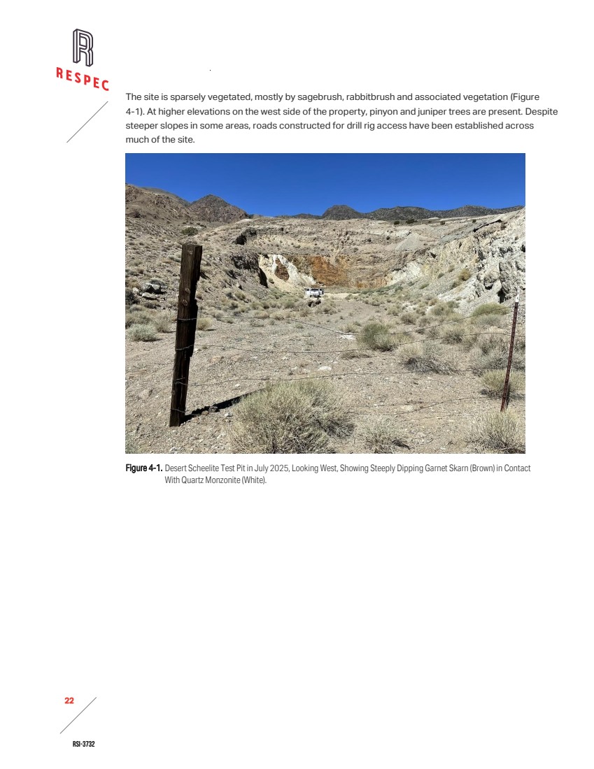
| RSI-3732 23 2 5.0 HISTORY The Pilot Mountain Tungsten Project has been subject to exploration activities since the early twentieth century, resulting in a substantial body of geological, geophysical, and drilling data. Despite this history of exploration, only limited production has been recorded. The sub-sections below provide a summary of past work and production history recorded at the Pilot Mountain Tungsten Project. Table 5-1 summarizes the drilling that historical operators completed at the Pilot Mountain Project from 1968-2017. Table 5-1. Summary of Historical Drilling by Operator Company Years Total Holes Type Total (m) Hecla Mining 1968 16 Percussion 1,652 Duval 1970-1977 66 Core, Percussion, Unknown 12,587 Grace 1975 5 Unknown 600 Union Carbide 1978-1980 185 Core, Rotary, Unknown 23,234 Black Fire 2011-2012 15 Core 3,047 Thor Mining 2017 9 RC 953 Total 296 42,073 5.1 EXPLORATION HISTORY 5.1.1 EXPLORATION -1900-1978 Scheelite was first discovered on the east flank of the Pilot Mountains in 1916 [Ross, 1961]. The discovery, as well as the discoveries of other similar skarn deposits in Nevada and California, directly resulted from a prospecting wave stimulated by high tungsten prices and the opening of several tungsten mills in the Bishop district in California [Hess and Larson, 1921]. Reportedly, several properties were developed at this time in the Pilot Mountains. However, none of them recorded any production. In 1921, Hess and Larson of the United States Geological Survey (“USGS”) inspected the district. They recognized the association of scheelite with the Gunmetal stock, mapped the location of tactites relative to the general outline of the stock, and identified three types of mineralization on the property: tactite, quartz-calcite-scheelite veins, and clots of quartz, calcite, silver-bearing galena, and scheelite. Hess and Larson considered the tactite mineralization to be the only type with significant tonnage potential. They examined the Gunmetal Adit on the northeast contact of the monzonite stock and reported a crushed zone along the stock contact with a "rather regular, nearly vertical vein which has slickensided walls and is from a few inches to three feet across, made up mostly of quartz, calcium-iron carbonate, and carrying some apatite, which is in part, at least, high grade scheelite ore" [Hess and Larson, 1921]. The adit followed this zone for about 185 feet. Hess and Larson observed grades up to 1% WO3 along this contact. |
| RSI-3732 24 2 Kerr [1946] reported that additional underground development work at the Gunmetal location had been disappointing. A long, crosscut tunnel that was driven through granite porphyry to intersect a projected tactite zone on the other side encountered only barren marble. Kerr also noted an association of quartz with higher-grade scheelite and the presence of quartz concentrations in the form of irregular, vertical, chimney-like masses, both within the granite porphyry and around its margins. Union Carbide Corporation (“UCC”) internal reports for the Garnet mine recorded a small production of 130 short tons through 1943 but presented no figures for Gunmetal. In 1952, Kenneth W. Dunham reopened the old Gunmetal Mine. UCC internal reports report approximately 15,378 short tons produced from Gunmetal between 1952-1956. Hecla Mining (“Hecla”) began exploring the Pilot Mountain property in 1968. To test porphyry Cu-Mo targets, Hecla drilled approximately 1,652m in 16 percussion holes between the Good Hope and Desert Scheelite zones and drilled several holes into tactite at Desert Scheelite. Hecla dropped the property after the drilling campaign. Duval Corporation (“Duval") leased the Desert Scheelite and Gunmetal properties in 1969. They completed ground magnetic and IP surveys. In 1970, Duval drilled four core holes totaling ~1,420m into an anomalous IP target south of Good Hope hoping to hit porphyry Cu-Mo mineralization. The holes only intersected weakly mineralized Cu-Mo quartz veins. Duval continued drilling in 1971 and encountered Cu-W mineralization in sulfide-rich tactite northeast of Desert Scheelite. In 1972 and 1973, they drilled seven additional core and percussion holes at Desert Scheelite. In 1975, W. R. Grace (“Grace") obtained a lease-option agreement on the property and drilled five angled drill holes, totaling about 728m, directed at the down-dip extension of the Desert Scheelite deposit. The program confirmed the width of the steeply dipping mineralization at Desert Scheelite, which had previously only been intersected in vertical drill holes. Grace did not exercise its option on the property. Duval continued exploration until 1977, when UCC optioned the property. UCC sampling programs in the underground exposures of the Gunmetal Mine averaged between 0.40 and 0.50% WO3. UCC evaluated the Duval geophysical and drilling data and initiated a ground magnetic survey and a drilling program to evaluate the property further. After their drilling intersected scheelite mineralization in both an extension of the Desert Scheelite and in the Middle Gunmetal/South Contact areas, UCC exercised their option to purchase Duval's interest in December 1978. UCC completed mining feasibility studies on the property and conducted trial mining on the Desert Scheelite deposit through a 70,000-tonne bulk sampling exercise. Low tungsten prices halted their activities. 5.1.2 EXPLORATION -2011-2021 Black Fire Minerals Ltd. (“Black Fire”) acquired an option on the property in September 2011 and completed a 15-hole drilling program designed to verify historical assay data. This program’s results |
| RSI-3732 25 2 supported the preparation of an initial mineral resource estimate for the Desert Scheelite deposit in 2012. Thor Mining PLC (“Thor”) acquired an interest in the property in 2014 and initiated a comprehensive exploration program that included a detailed review of archival data generated by UCC. In 2017, Thor completed nine holes targeting copper-silver mineralization within the Desert Scheelite and Garnet deposits. 5.2 HISTORICAL MINERAL RESOURCE ESTIMATES In 2012, Black Fire commissioned the first modern mineral resource estimate for the Desert Scheelite deposit. That estimate, prepared in accordance with the JORC (2004) Code, outlined tungsten resources with copper and silver credits. Following additional drilling and project advancement, Thor Mining updated the resource estimate in 2018. The revised estimate reported 10.7 million tonnes at 0.26% WO₃, 19.4 g/t Ag, 0.15% Cu, and 0.38% Zn above a 0.15% WO₃ cut‑off, with the majority classified as indicated resources. The 2018 update incorporated zinc into the resource inventory for the first time, which added a potential by‑product stream to the project [RES, 2018]. The reader is cautioned not to treat the mineral resources estimate discussed above, or any part of them, as current mineral resources or mineral reserves. A qualified person has not done sufficient work to classify these historical estimates as current mineral resources or mineral reserves. Neither RESPEC nor Guardian is treating these historical estimates as current estimates. The historical mineral resource estimate discussed above is relevant only for historical completeness. RESPEC did not rely on any of the previous resource estimates in preparing the current work. The mineral resources reported in Section 11.0 of this technical report summary supersede Thor’s 2018 estimate and are the Desert Scheelite deposit’s only current mineral resources. |
| RSI-3732 26 2 6.0 GEOLOGICAL SETTING, MINERALISATION, AND DEPOSIT 6.1 GEOLOGICAL SETTING The geology and geologic setting of the Pilot Mountain property were originally described in Union Carbide’s Pilot Mountain Project Geologic Setting and Field Trip Guide prepared by D. E. Grabher [1984], which is the primary source for much of the following information. RESPEC has reviewed it and other sources and considers the information they present to be a materially accurate summary of the geology and mineralization of the Pilot Mountain property as presently understood. 6.1.1 REGIONAL GEOLOGY The Pilot Mountain property lies within the Walker Lane structural belt of western Nevada, a northwest‑trending zone of strike‑slip faulting, extensional basins, and associated magmatism that accommodates a significant portion of the displacement between the Pacific and North American tectonic plates. The Walker Lane is interpreted as an incipient transform boundary, with deformation expressed through complex fault networks, localized subsidence, and magmatic intrusions that have influenced mineralization patterns across the belt [Faulds and Henry, 2008]. The oldest rocks in the Pilot Mountain area occur within the Luning allochthon, a thrust‑stack containing up to thirteen nappes, each generally composed of a single lithologic unit. These rocks range in age from Permian to Jurassic and are dominantly calcareous in the Pilot Mountains [Grabher, 1984; Oldow, 1978]. The allochthon was emplaced along the Luning thrust, a regionally extensive structure formed during the Nevadan–Laramide orogeny, which juxtaposed units of contrasting depositional and deformational histories. Geologists interpret the age of thrusting as lying between post‑late Early Jurassic (~175Ma) and Late Cretaceous (~68.7Ma) [Grabher, 1984; Speed, 1977]. During the Early to Middle Jurassic, orogenic movements resulted in quartzose sandstones and other clastic rocks being deposited unconformably over older sediments. Volcanic material becomes progressively more abundant within the Jurassic successions, indicating that magmatism intensified in response to ongoing orogenic activity. Igneous intrusions emplaced between the Jurassic and Tertiary periods cut the layered rocks of the region. Smaller stock‑like bodies of Cretaceous granodiorite– quartz monzonite and a Tertiary rhyodacite dome also occur in the Pilot Mountains [Grabher, 1984; Nielsen, 1963]. Skarn mineralization is associated with some of the intrusions. In the Middle to Upper Tertiary, widespread felsic to intermediate volcanic rocks were emplaced across the region. These volcanic units outcrop extensively and locally host precious‑metal mineralization outside the Pilot Mountain project area. Later tectonic activity in the region is expressed as northwest‑trending, right‑lateral faulting associated with the Walker Lane belt. This deformation overprints earlier structures, but basin and range faulting, which is prominent to the northeast in central Nevada, is not well developed within the Walker Lane corridor. |
| RSI-3732 27 2 6.1.2 PROPERTY GEOLOGY The Pilot Mountain project area is underlain by a thick succession of Permian to Jurassic sedimentary and volcanic rocks locally intruded by Cretaceous granitic stocks, dykes, and sills and overlain around the margins by Tertiary volcanic units. These rocks have been complexly deformed by thrust faulting and have a combined stratigraphic thickness that exceeds 6,000m. The oldest unit exposed is the Permian Mina Formation, a thick accumulation of marine turbidites, chert, and volcanogenic tuffaceous strata. South of the Desert Scheelite resource area, the Permian Mina Formation is prominently exposed in high cliffs across a major fault scarp. The Mina is overlain by the Triassic Luning Formation, the principal host of mineralization on the property. Although no continuous stratigraphic section is preserved locally, the Luning is at least 2,300m thick in its type locality and is subdivided into lower, middle, and upper members. / The lower Luning member, which hosts mineralization at Desert Scheelite, is ~800m thick and composed of ~60% clastic rocks and ~40% carbonates. Lithologies include fine‑grained crystalline limestone and bioclastic carbonate (calcarenite) beds ranging from centimeters to 30m thick. Fossils, particularly shallow‑water ammonites, are locally abundant. / The middle Luning member crops out in thicknesses of 100–450m. It forms gradational contact with the lower member and consists of interbedded conglomerate, arenite, wacke, and sandy mudstone. / The upper Luning member, which hosts mineralization in the Gunmetal–Garnet areas, is composed of ~80% limestone and ~20% fine‑grained clastic rocks. Massive calcarenite beds up to 5m alternate with thin‑bedded limestone, limey mudstone, and sandy mudstone up to 10m thick. The Lower Jurassic Dunlap Formation overlies the Luning with disconformable contact and is locally exposed along the southwestern edge of the property. It is ~1,500m thick in the central Pilot Mountains and records both subaerial and submarine depositional environments. Lithologies include sandstone, siltstone, shale, conglomerate, and minor bioclastic limestone and tuff. Intrusion of a Jurassic biotite quartz monzonite stock produced contact metamorphism, converting adjacent carbonate rocks to marble and pelitic clastics to hornfels. Skarn and calc‑silicate alteration formed locally by metasomatic processes within marble and calcareous metaclastic units during the latter phases of emplacement. Evidence of metamorphism extends up to 300m laterally from the northern contact of the stock, although significant mineralization in the modeled resource area is largely confined to within ~90m of the contact. The southern contact of the stock is concealed beneath Quaternary alluvium and sheetwash deposits [Golder, 2012]. |

| RSI-3732 28 2 Figure 6-1. Property Geology of the Pilot Mountain Tungsten Project. |
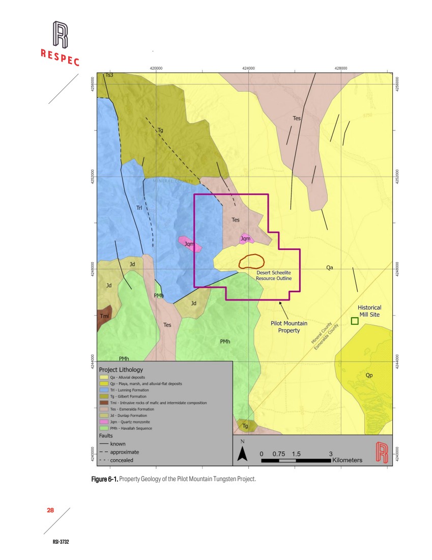
| RSI-3732 29 2 Figure 6-2. North-South Cross-Section 424305E Showing Tungsten Mineral Domain and Geology. COORDINATE SYSTEM: UTM WGS84 Zone 11N DATE: 17 November, 2025 RESPEC Reno Office 210 South Rock Blvd. 775.856.5700 %WO3 : <0.005 0.005 - 0.02 0.02 - 0.1 0.1 - 0.2 >0.2 Drill-Hole Assays Color: Mineralized Domain Clastic Sedimentary Hornfels Quartz Monzonite Marble Calcarious Sedimentary Overburden Domains Pilot Mountain Tungsten Project Mineral County, Nevada Tungsten Domains Section 424305 4248200 4248400 1600 1800 Meters 0 15 30 $65,500 Pit $65,500 Pit |
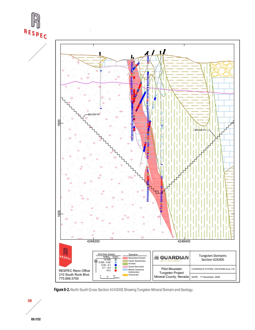
| RSI-3732 30 2 Figure 6-3. Generalized Stratigraphic Column for the Pilot Mountain Tungsten Project. |
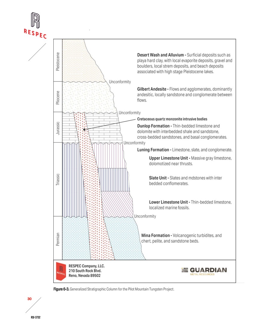
| RSI-3732 31 2 Near the intruding quartz monzonite stocks, large areas of the Luning Formation’s carbonate section have undergone recrystallization accompanied by bleaching. These effects have obscured original sedimentary structures and fossil remains. The degree of recrystallization varies from bed to bed, with some units becoming very coarsely crystalline. Calc‑silication of marbles and conversion of mixed calcareous–argillaceous and marly sediments to calc‑silicate hornfels is widespread. The character of the altered rock depends largely on the original composition, though metasomatic processes may also have contributed. Thin diopside–feldspar– tremolite–clinozoisite beds of marly origin, as well as dense, light‑colored diopside–tremolite– K‑feldspar marbles, occur near mineralized centers but predate tungsten mineralization [Grabher, 1984]. Toward mineralized centers, the distinction between purely metamorphic and metasomatic effects becomes less clear. Hornfels typically darken to green, and pale grossularitic garnet and idocrase appear as lenses, veinlets, or knots within the marbles. Veinlets containing garnet, thulite, idocrase, tremolite, clinozoisite, and K‑feldspar crosscut the hornfels or follow bedding planes. Lenticular masses of grossularite garnet + idocrase ± sericite also occur in proximity to skarn [Grabher, 1984]. 6.2 DEPOSIT TYPE The Desert Scheelite deposit is a tungsten skarn deposit. Tungsten skarn deposits in the Great Basin formed along the North American Cordilleran magmatic arc, where granitic to granodioritic plutons intruded carbonate-rich basement rocks. Great Basin skarns are concentrated along the margins and roof zones of the Sierra Nevada batholith in California and in dispersed plutons across Nevada. The host rocks include Paleozoic continental shelf and slope facies dominated by limestone, dolomite, and mixed siliciclastic assemblages, as well as Triassic to Jurassic back-arc basin carbonates interlayered with volcaniclastic and siliciclastic units. Skarn ages range from Jurassic to Cenozoic, with most deposits forming during the Cretaceous, coincident with pulsed Cordilleran arc magmatism and crustal thickening [Lederer et al, 2021]. Plutons associated with tungsten skarns are typically coarse-grained granitoids crystallized at depths greater than 3km. Extensive fractional crystallization enriched incompatible elements, such as tungsten, in residual felsic melts. Tungsten partitioned into chlorine-rich magmatic fluids, driving metasomatic alteration of carbonate host rocks. Both reduced and oxidized plutons can generate tungsten skarns, though the highest grades are commonly linked to reduced granitic intrusions [Lederer et al, 2021]. Metasomatism produced zoned calc-silicate assemblages through prograde and retrograde crystallization. Prograde skarn minerals include garnet, pyroxene, and wollastonite, while retrograde assemblages are dominated by epidote, amphibole, and chlorite. Skarn geometry can vary with depth of formation. Deep systems (>5–10km) can form as narrow, vertically extensive bodies along plutonic contacts, whereas shallow systems (<5km) can be more broadly developed and display intense retrograde alteration due to meteoric water influx. Economic tungsten mineralization is typically restricted to exoskarns, where scheelite occurs as the dominant ore mineral [Lederer et al, 2021]. |
| RSI-3732 32 2 6.3 MINERALIZATION The mineralization‑hosting skarn at Pilot Mountain is classified into two principal compositional types: pyroxene‑rich skarn and garnet‑rich skarn. The garnet‑rich variety occurs in two subtypes, one enriched in base metals and one relatively base‑metal poor. Skarn composition is largely controlled by the character of the host carbonate rocks, while the degree of base‑metal enrichment appears to reflect the geochemical variability of the individual quartz monzonite stocks that intruded the sequence. 6.3.1 DESERT SCHEELITE The Desert Scheelite deposit is a base‑metal enriched tungsten skarn developed within lower Luning Formation carbonates and interbedded biotite hornfels. The skarn zone extends for approximately 600m along the contact of the Desert Scheelite quartz monzonite stock and persists for at least 300m down‑dip. The skarn dips steeply north, containing two mineralized zones on both the footwall and hanging wall sides. Garnet compositions, based on limited petrographic and X‑ray diffraction studies, are dominantly grossular‑andradite solid solution, with Fe‑rich andradite rims on garnet porphyroblasts [Grabher, 1984]. Mineralization is characterized by abundant scheelite, along with pyrite and base‑metal sulfides, principally chalcopyrite and sphalerite, which locally exceed 20% in unoxidized samples. Tungsten grades within this skarn are notably consistent compared to other deposits on the property. Desert Scheelite contains relatively abundant ankerite and siderite, in addition to pyroxene and quartz. Both iron carbonates and quartz are observed replacing garnet [Grabher, 1984]. 6.3.2 GARNET Both garnet skarns and pyroxene skarns are present at the Garnet deposit. Garnet skarns are commonly interbedded with marble and early‑stage pyroxene skarns. Mineralization occurs as high‑grade scheelite horizons within pyroxene–quartz–garnet skarn and as disseminations in the outer rims of zoned, porphyroblastic garnets set in a calcareous matrix. At depth, pyroxene skarns are expressed in two distinct subtypes: (1) a dark green pyroxene skarn with brown garnet veinlets developed from an inferred dolomitic limestone host, which outside the altered zone contains chlorite and serpentine bands; this subtype is consistently very low‑grade to barren in scheelite, though molybdenite may occur; and (2) a scheelite‑rich skarn, possibly formed by replacement of pre‑existing diopside–tremolite hornfels layers, characterized by quartz and fibrous amphibole replacing coarse tremolite and diopside, occurring as beds up to 60cm thick and as a green matrix enclosing dark brown isotropic garnet porphyroblasts, which themselves are barren [Grabher, 1984]. 6.3.3 GUNMETAL Exposures at the Gunmetal deposit are characterized by low‑sulfide garnet skarn. The skarn exhibits both contact‑related vertical replacement and flat‑lying stratiform replacement of upper Luning carbonates. Petrographic and X‑ray diffraction studies indicate garnet compositions within the grossular‑andradite solid solution, with Fe‑rich rims on garnet porphyroblasts [Grabher, 1984]. |
| RSI-3732 33 2 Pyroxene and quartz are the principal accessory minerals. Scheelite grades vary both between beds and with distance from the intrusive contact, with higher grades adjacent to marble and lower grades near quartz monzonite. The deposit also contains a narrow contact skarn and multiple stratiform skarns extending outward from the Gunmetal stock. These skarns are generally thinner, but locally include a zone of thin, higher‑grade skarn interbedded with thicker barren hornfels. |

| RSI-3732 34 2 7.0 EXPLORATION Since acquiring the Pilot Mountain project in 2021, Guardian has advanced exploration through a combination of data review, updated geological modeling, and targeted drilling programs. Work has focused on validating the historical resource base, assessing extensions of known mineralization, and collecting samples to support metallurgical and geotechnical evaluations. These activities provide the foundation for ongoing technical studies and a planned pre‑feasibility assessment, with detailed results and methodologies discussed in the subsections that follow. Given the early stage of the project, only preliminary hydrological or geotechnical investigations have been conducted at the Pilot Mountain deposits. 7.1 ROCK CHIP SAMPLING In June 2024, Guardian conducted closely spaced rock-chip sampling and whole‑rock geochemical analysis of the quartz monzonite intrusions on the property to determine whether their geochemical signatures are consistent with porphyry Cu‑Mo systems. Guardian also collected hydrothermally altered wall rocks south of the Porphyry South magnetic anomaly. Guardian submitted 12 quartz monzonite samples to ALS for whole‑rock geochemical analysis. The results returned element ratios (Sr/Y > 80; La/Yb > 20; Yb < 1.5) and Eu anomalies > 0.9, values that align with adakitic geochemical signatures commonly associated with Cu‑Mo porphyry intrusions. These findings indicate that the Pilot Mountain quartz monzonite exhibits geochemical characteristics consistent with globally recognized porphyry systems. Guardian also collected nine representative rock‑chip samples south of Desert Scheelite and Porphyry South. Eight samples contained >150ppm Cu, three exceeded 550ppm Cu, and two returned values of 691ppm Cu with 201ppm Mo and 799ppm Cu. These anomalous copper concentrations occurred in quartz-sericite-pyrite (“QSP”) altered metasedimentary rocks located 500–700m to the south of the Porphyry South anomaly. Copper showings included chrysocolla, malachite, and chalcocite associated with oxidized sulfide‑bearing quartz veins. Guardian’s geochemical results suggest that copper mineralization is present over a broad area adjacent to the quartz monzonite intrusions. In 2025, Guardian continued exploration at Porphyry South. Guardian’s work included detailed mapping of intrusions, porphyry dykes, copper occurrences, sulfides, and quartz vein density. Guardian collected 189 outcrop rock chip samples, analyzed by four‑acid digestion with ICP‑MS/ICP‑AES. Results confirmed elevated copper and molybdenum across Porphyry South. Along a ~1km east-west ridge of gossanous breccia, 15 rock-chip samples returned copper values above 1,000ppm, including a maximum of 2.05% Cu. Petrographic analysis confirmed cuprite, malachite, and tenorite within the breccia. Two smaller clusters of mineralized outcrops south of the quartz monzonite intrusion also yielded copper concentrations >500ppm. Trace element geochemistry showed elevated arsenic (>50ppm), selenium (>2ppm), and tellurium (>0.1ppm), consistent with QSP alteration and indicative of the phyllic alteration zone, which commonly surrounds porphyry system cores. |
| RSI-3732 35 2 7.2 GEOPHYSICAL SURVEYS In June 2023, while operating under the name Golden Metal Resources PLC, Guardian completed a high‑resolution induced polarization (“IP”) geophysical survey across the Pilot Mountain Project. The program encompassed the Desert Scheelite deposit and adjacent quartz monzonite stock, and it delineated three significant chargeability anomalies interpreted as disseminated sulfide mineralization. These anomalies provided early evidence of possible porphyry‑style systems and defined priority targets for follow‑up exploration. In 2025, Guardian completed a three‑dimensional induced polarization (“3DIP”) survey targeting porphyry-style alteration and mineralization that extended coverage southward from the 2023 IP survey area. The 3DIP results, integrated with the 2023 IP, confirmed the presence of chargeability anomalies. Although geophysical work remains at an early-stage relative to drilling and metallurgical studies, the results may provide support for refinement of exploration targets and potential resource expansion. 7.3 DRILLING Table 7-1 summarizes the meters drilled in each target area at the Pilot Mountain Project. Guardian has drilled a total of 89 core drill holes, which includes 68 holes at the Desert Scheelite deposit, 20 holes at the Garnet deposit, and one hole targeting Porphyry South. All drilling was conducted using diamond core methods, and drill-hole locations were surveyed by contracted professional land surveyors. Table 7-1. Guardian Drilling in 2024-2025 Target Type of Drilling Total Holes Total (m) Desert Scheelite Core 68 8,471 Garnet Core 20 1,466 Porphyry South Core 1 407 Total 89 10,344 Guardian contracted Diamondback Drilling, who operated Boart Longyear LF Super 90 rigs for core drilling. The crew applied barium‑based grease with organic compounds during coring. At shallow depths, they advanced short runs of one to two feet to manage broken core. The crew relied on mechanical methods to remove core from the barrel, including hammering the outside with a rubber mallet or claw hammer, ramming a metal stake into the back end, and shaking the barrel when necessary. The crew labeled cardboard core boxes with Guardian information, including hole ID, box number, and from and to depths. They marked each run with wood blocks noting footage, interval length, and recovered length in feet. The crew washed tubes and core with a plastic brush and water before placing samples in boxes, ensuring clean presentation and accurate labeling. As drilling progressed, core recovery improved, with later runs producing more intact samples. |
| RSI-3732 36 2 Figure 7-1. Map of Drill Holes at the Pilot Mountain Project. Advanced Surveying & Professional Services (“ASPS”) surveyed all the drill collar locations for the 2024–2025 program, along with 30 historical collars that remained physically identifiable on the project site. All collar positions were reported in Universal Transverse Mercator (“UTM”) coordinates using the WGS84 geodetic datum. Guardian collected down-hole survey readings for the 2024–2025 drilling program at 10m intervals using the Gyromaster instrument manufactured by Stockholm Precision Tools. |
| RSI-3732 37 2 8.0 SAMPLE PREPARATION, ANALYSIS, AND SECURITY 8.1 SAMPLE METHODS AND QA/QC 8.1.1 GUARDIAN METALS SAMPLING METHODS Every day of active drilling, Guardian geologists transported drill core from the drill site to the core facility in Hawthorne, Nevada. Once there, they placed the core on racks, pieced together and washed the core, and converted footages to meters labeled on the boxes and wood blocks. The geologists logged recovery, RQD, the primary and secondary lithologies, color, the presence and intensity of carbonate and quartz veining, faulting and structural intensity, alteration type and intensity, mineralization with visual estimates of modal mineral percentages, and the oxidation minerals present. They also documented jointing and other structural features and the redox state. Guardian geologists selected sample intervals based on geology (e.g., skarn, oxidation zones). Intervals ranged from a minimum of 0.1m to a maximum of 1.5m. The geologists stapled pre‑numbered sample tags into the core box at the beginning of each run, with two tags inserted when duplicates were required. They marked sample intervals directly on the core with red lumber crayon and used blue crayon to mark UV-fluorescent scheelite, and yellow crayon to indicate powellite. The geologists initiated sampling once mineralized zones were encountered in the core and continued sampling through the entire mineralized interval. To ensure representative coverage, 5m of buffer samples were collected on both sides of each mineralized zone. Guardian geologists photographed wet and dry core samples. Recently, they began photographing core boxes under UV light to highlight scheelite, powellite, and calcite fluorescence. After logging, the geologists placed core boxes next to the core saw. Sampling technicians cut the core from the top of the hole downward using a bench‑mounted saw. Cutters consistently sampled the right side of the core and returned the left side to the box in its original sequence. They sampled broken or rubbly intervals by volume. To make field duplicates, the cutters split the right half again, producing two quarter‑core samples. Technicians placed samples in large cloth bags with bar‑coded tags attached to the label, also inserted bar‑coded tags inside the bag, and transferred the bagged samples to supersacks labeled with the ALS client code and batch number. For quality assurance/quality control (“QA/QC”), Guardian geologists inserted certified reference materials (“CRMs” or “standards”), blanks, and field, coarse, and pulp duplicates at defined frequencies into the sample register. The QA/QC samples were placed in gallon Ziplock bags with sample tags and hole numbers on the bag. The crew palletized the supersacks, which were stored inside a locked Quonset hut. Guardian personnel delivered the supersacks directly to the ALS laboratory in Reno, Elko, or Carson City. Guardian personnel obtained chain-of-custody documentation at the lab and scanned the documentation into the project database. Guardian geologists also collected density samples every 10m. They wax‑coated the density samples and measured their densities using the water immersion method without oven drying for dry weight. They chose density samples to represent the range of lithologies, alteration types, and mineralization styles present. However, only intact samples were measured, so lithologies that tended to be broken or fractured might not be accurately represented. |
| RSI-3732 38 2 Guardian stores historical core outside under tarps in shipping containers that are not within the locked facility. 8.1.2 HISTORICALSAMPLING METHODS RESPEC reviewed drilling and sample collection methods conducted by Black Fire and Thor, relying primarily on prior reports prepared under JORC standards to compile available details [Golder 2012, RES 2018]. In 2012, Black Fire contracted Timberline Drilling Inc. (“Timberline”) to conduct core drilling using a track-mounted Boart Longyear LF90 drill rig. The drillers pre-collared the first 30m with a tri-cone roller bit due to poor ground conditions. RESPEC is not aware of any documentation identifying the specific procedures employed during drilling and core recovery. Black Fire geologists logged recovery, RQD, and the quality of the mark for core orientation. They also recorded UV fluorescence, lithology, alteration, mineralization, veining, and structures on geologic logs. Black Fire personnel photographed wet and dry core and marked samples on geological intervals using pre-numbered sample registers. Black Fire technicians cut the core, sent half for analysis, and retained the remaining half for reference. Black Fire personnel submitted QA/QC samples, including CRMs and blanks, with the core samples. RESPEC is not aware of any additional documentation identifying the specific procedures used for sampling and QA/QC insertion beyond what is available in the Golder [2012] and RES [2018] reports. Black Fire stored samples in a locked shed at Black Fire’s facility in Hawthorne, Nevada. After the completion of each hole, a Black Fire technician delivered the samples to ALS in Reno, Nevada. RESPEC does not have documentation indicating which drilling contractor or rig Thor used for the RC drilling they conducted. The drill crew collected 2kg subsamples at 0.76m (2.5ft) intervals using a rotary splitter. Thor personnel collected, logged, and photographed chip tray samples. Thor geologists logged UV fluorescence, lithology, alteration, and mineralization. RESPEC is not aware of any additional documentation identifying the specific procedures Thor used to manage sampling and QA/QC insertion beyond what they reported. Thor stored samples in a locked shed at their facility in Hawthorne, Nevada. A Thor technician delivered the samples to ALS in Reno, Nevada. RESPEC has not identified or reviewed any documentation detailing the sample handling, preparation, security procedures, or chain of custody protocols employed during the 1970s drilling at the Pilot Mountain project. 8.2 SAMPLE PREPARATION 8.2.1 GUARDIAN METALS SAMPLE PREPARATION AND ANALYTICAL METHODS ALS Laboratories in Reno, Nevada prepared and analyzed the samples Guardian submitted using established geochemical methods suitable for multi-element and ore-grade analysis. To conduct the initial assays for tungsten, silver, copper, and zinc, ALS used method ME-ICP61, a four-acid digestion |
| RSI-3732 39 2 followed by inductively coupled plasma–atomic emission spectroscopy (“ICP-AES”). This methodology provides reliable detection across a broad range of metal concentrations. To ensure accurate quantification of initial assays that exceeded upper detection limits (overlimits), ALS re-analyzed overlimit samples using ore-grade methods. ALS re-assayed overlimit silver samples using aqua regia (“OG46”) and four-acid (“OG62”) methodologies. ALS used OG62 to re-assay overlimit copper and zinc samples. These methods incorporate enhanced digestion and detection protocols designed for high-concentration samples. Any tungsten samples that reported greater than 1,300ppm W were re-analyzed using x-ray fluorescence (“ME-XRF15c”), a pressed pellet technique appropriate for quantifying tungsten trioxide (“WO3”) in high-grade material. ALS Laboratories is accredited to ISO/IEC 17025 for laboratory competence and ISO 9001 for quality management systems. These certifications confirm that ALS maintains rigorous analytical protocols and traceable procedures. RESPEC knows of no relationship between ALS and Guardian other than that of an independent commercial laboratory providing analytical services to a client. 8.2.2 HISTORICALSAMPLE PREPARATION AND ANALYTICAL METHODS Analytical protocols for the Black Fire and Thor drilling campaigns at Desert Scheelite involved standardized sample preparation and multi-element analysis conducted by ALS. Upon receipt, ALS registered, weighed, dried, and crushed the samples to achieve greater than 70% passing a 2mm screen. The lab then obtained a 1,000g split and pulverized it to greater than 85% passing a 75-micron screen. ALS subjected a portion of the prepared samples to a multi-acid digestion method suitable for near-total decomposition of silicate-rich material, then performed the elemental analysis using ICP-AES. To confirm analytical consistency, American Assay Laboratories (“AAL”) processed check samples using the same methodology. AAL is accredited under ISO/IEC 17025:2017, covering both sample preparation and analytical procedures. RESPEC knows of no relationship between ALS or AAL and Black Fire or Thor other than that of an independent commercial laboratory providing analytical services. Guardian recovered a partial set of original assay certificates from the 1970s drilling programs conducted by UCC and Duval. These records provide limited insight into the analytical work performed for some of the assays obtained during that period. The laboratories identified in the available documentation include Rocky Mountain Geochemical, Skyline Labs, and Southwestern Assayers and Chemists. Sample preparation techniques used by these laboratories were not recorded in the available documentation and remain unknown to RESPEC. The analytical methods employed included atomic absorption spectroscopy for multi-element analysis and colorimetric techniques for tungsten determination. Certification status for these laboratories during the 1970s is not fully documented. However, Skyline Labs is known to have held ISO 9001:2015 and ISO 17025:2017 certifications in later years, while no |
| RSI-3732 40 2 publicly available records confirm accreditation for Rocky Mountain Geochemical or Southwestern Assayers and Chemists. 8.3 QUALITY ASSURANCE/QUALITY CONTROL RESPEC compiled and evaluated QA/QC results from Guardian’s 2024–2025 drilling programs and reviewed published QA/QC data for Black Fire and Thor. Results from CRMs, blanks, and field duplicates are summarized and discussed in this section. Certified Reference Materials CRMs are powdered materials containing known concentrations of target metals and are used to assess analytical accuracy. Commercial suppliers provide certified values and associated standard deviations derived from multiple laboratory analyses. Analytical results are typically considered acceptable when they fall within the certified value ± three standard deviations. Blanks Blanks contain metal concentrations below detection limits and are used to monitor laboratory contamination. Two types are commonly used: coarse blanks and analytical (pulp) blanks. Coarse blanks are crushed and pulverized through the full preparation process and are most effective for detecting contamination introduced during sample preparation. Analytical blanks, consisting of barren pulp material, monitor contamination at the analytical stage but are less diagnostic. Blanks returning values greater than five times the detection limit are considered failures. Duplicates Field duplicates are secondary splits of drill core or reverse circulation (“RC”) samples collected at the drill site or during core sampling. They are used to evaluate the natural heterogeneity of metal distribution in the deposit but also provide a measure of sampling precision and can identify potential issues with sample splitting. Preparation duplicates are coarse reject splits usually prepared by the laboratory at the request of project staff. Pulp duplicates are also produced by the lab for their internal QA/QC programs. 8.3.1 GUARDIAN METALS QA/QC RESULTS CERTIFIED REFERENCE MATERIAL 2024-2025 During their 2024-2025 drill programs, Guardian used a combination of commercially produced and internally prepared CRMs. They obtained a commercial CRM from Geostats Pty Ltd. (“Geostats”) and another from CDN Resource Laboratories Ltd. (“CDN”). Both CRMs were certified for tungsten, but the CRM from CDN was also certified for copper (Table 8-1). Internally prepared standards were derived from Desert Scheelite drill material collected by Guardian and certified for tungsten, silver, copper, lead, and zinc through round-robin testing managed by Moment Exploration Geochemistry Labs (“MEG”). The insertion rate for CRMs in Guardian’s drilling program was approximately 6% for tungsten assays. |
| RSI-3732 41 2 Table 8-1. CRMs Used by Guardian Metals CRM ID Source Drill Years Insertion Count Certified W ppm W Std Dev ppm Certified Ag ppm Ag Std Dev ppm Certified Cu ppm Cu Std Dev ppm Certified Zn ppm Zn Std Dev ppm CDN-W-4 CDN 2024- 2025 25 3,660 240 1,390 80 GW-02 Geostats 2024- 2025 6 1,231 20 W311001X Guardian 2024- 2025 36 1,930.8 224.1 52.06 1.74 42,370.3 1,378.1 7,236.2 293.3 W311002X Guardian 2024- 2025 24 1,401.7 77.2 10.73 1 2,859.36 80.54 4,037.2 255.6 W311003X Guardian 2024 4 3,550.2 318.3 20.93 1.17 357.03 17.72 10,221.7 486.4 Table 8-2 summarizes the evaluation of tungsten, silver, copper, and zinc analyses in all CRMs used by Guardian. Analytical performance was generally within acceptable limits, and no consistent analytical bias evident across elements. Tungsten shows a modest negative bias (-3% to -10%) relative to the expected values, while copper and zinc results are close to the certified values, with biases typically less than ±6%. Silver results display greater variability, including a few isolated high values, but these do not indicate a systematic analytical issue. Overall CRM failure rates across all elements were low (Table 8-3), with 14 failures out of 312 insertions (4.5%). Tungsten returned 5 failures from 95 CRMs (5.3%), including four low and one high outlier. Silver exhibited the highest failure rate, with 6 failures from 64 CRMs (9.4%), all on the high side. Copper showed 2 failures from 89 CRMs (2.2%), both high outliers, while zinc returned 1 failure from 64 CRMs (1.6%). These results indicate generally strong QA/QC performance, with silver showing comparatively higher variability. The apparent copper and zinc failures for CRM W311002X may be attributed to potential mislabeling, as the copper and zinc results are consistent with the typical values reported for W311001X and W311003X. However, this possibility cannot be confirmed. The five silver failures in W311001X are interpreted as genuine analytical inaccuracies, likely reflecting greater-than-expected variability in ALS’s silver analyses, as indicated by the higher standard deviation observed for this CRM. The cause of the high failure rate of GW-02 is unknown. No clear analytical or procedural cause was identified, although due to the limited number of insertions, it is difficult to evaluate the issue further. RESPEC is not aware of the specific steps Guardian undertook with ALS to address CRM assay failures. |
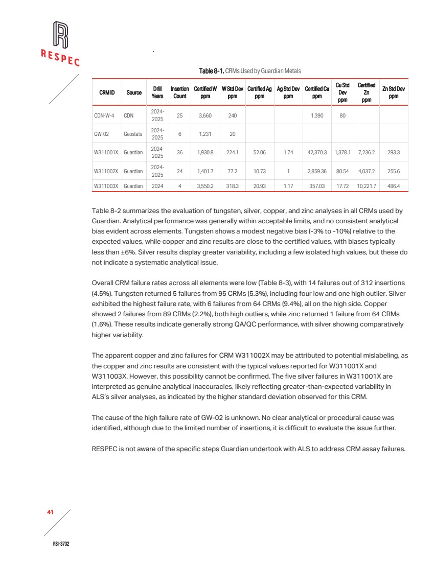
| RSI-3732 42 2 Table 8-2. Summary of Analyses for Guardian Certified Reference Materials 2024-2025 CRM ID Period Laboratory Element Insertions Expected Value ppm Grades in ppm Failure Counts Bias as % Low Mean High Low High CDN-W-4 2024- 2025 ALS W 25 3,660 3,380 3,499 3,610 0 0 -4.4 CDN-W-4 2024- 2025 ALS Cu 25 1,390 1,340 1,396 1,460 0 0 0.4 GW-02 2024- 2025 ALS W 6 1,231 1,130 1,158 1,220 4 0 -5.9 W311001X 2024- 2025 ALS W 36 1,931 1,590 1,730 1,820 0 0 -10.4 W311001X 2024- 2025 ALS Ag 36 52.1 51.4 54.1 56.6 0 5 4.0 W311001X 2024- 2025 ALS Cu 36 42,370.3 40,400 42,330 44,200 0 0 -0.1 W311001X 2024- 2025 ALS Zn 36 7,236.2 6,990 7,386.9 7,730 0 0 2.1 W311002X 2024- 2025 ALS W 24 1,402 1,270 1,357.9 1,700 0 1 -3.2 W311002X 2024- 2025 ALS Ag 24 10.7 10.4 13.0 55.0 0 1 20.9 W311002X 2024- 2025 ALS Cu 24 2,859 2,690 3,186.7 10,000 0 2 11.5 W311002X 2024- 2025 ALS Zn 24 4,037 3,870 4267.1 7400 0 1 5.7 W311003X 2024- 2025 ALS W 4 3550.2 2960 3237.5 3410 0 0 -8.8 W311003X 2024- 2025 ALS Ag 4 20.9 20.2 21.5 23.1 0 0 2.8 W311003X 2024- 2025 ALS Cu 4 357 340 351.3 368 0 0 -1.6 W311003X 2024- 2025 ALS Zn 4 10221.7 10550 10620 10700 0 0 3.9 Table 8-3. CRM Failures by Metal Metal Total CRMs Low High Failures Total Rate W 95 4 1 5 5.3% Ag 64 0 6 6 9.4% Cu 89 0 2 2 2.2% Zn 64 0 1 1 1.6% Total 312 4 10 14 4.5% |
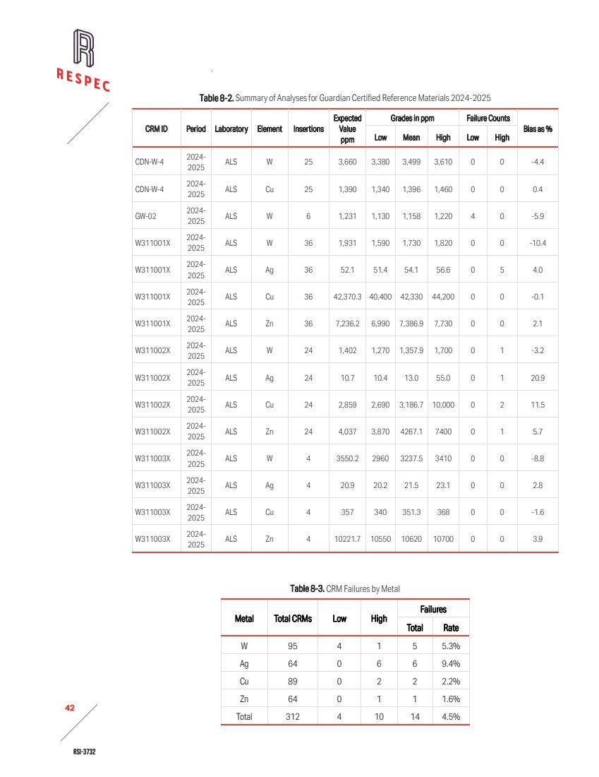
| RSI-3732 43 2 BLANKS 2024-2025 The blanks used during 2024–2025 were procured from MEG Labs and are certified. They consist of rhyolite cobbles sourced from western Nevada. The insertion rate was approximately 6%. For tungsten, 51 of the 92 analyses reported results below the detection limit of 10ppm W. Thirty-nine analyses returned between 10 and 60ppm W, below the warning limit of 100ppm W. Two analyses, at 130ppm W and 2,350ppm W, followed the processing of higher-grade samples and indicates limited contamination occurred during sample processing. For silver, 91 of the 92 analyses returned results below the detection limit of 0.5ppm Ag, with one blank assay at 7.7ppm Ag considered a failure. For copper, 9 of the 92 analyses reported results below the detection limit of 1ppm Cu. Sixty-seven analyses reported between 1 and 9ppm Cu, below the warning limit of 10ppm Cu. Sixteen analyses exceeded 10ppm Cu and indicate minor contamination during sample preparation after higher-grade samples were processed. One failure at 4,050ppm Cu corresponded to the same blank that returned 2,350ppm W. The coarse blank returned repeated failures for zinc. However, the blank material had not been evaluated or certified for zinc and may therefore be unsuitable for monitoring potential contamination of this element. Consequently, the zinc blank results are not considered reliable indicators of laboratory or sample preparation contamination. Although RESPEC does not know what follow-up actions, if any, Guardian undertook regarding the errant blank assays, the isolated failures for tungsten, silver, and copper do not indicate a systematic contamination issue during sample preparation at the laboratory. FIELD DUPLICATES 2024-2025 Guardian collected 34 field duplicates, consisting of quarter-core splits. RESPEC evaluated the results for these statistically, on scatterplots, and relative percent difference (“RPD”) analyses. The results are summarized in Table 8-4. Table 8-4. Summary of Results for Field Duplicates in 2024-2025 Type Start Date End Date Metal Counts RMA Regression Rel Pct Diff Corr Coeff All Used Outliers (y = dup, x = orig) ¼ core field duplicate Sep-24 May-25 W 34 34 0 y = 1.036x - 24.022 3.5 0.958 Ag 34 29 2 y = 0.897x + 0.228 –10.9 0.962 Cu 34 34 0 y = 0.987x + 39.662 –1.3 0.998 Zn 34 34 0 y = 1.009x + 2.377 0.9 0.992 The RPDs for the elements in Table 8-3 indicate minimal bias between analyses of original and field duplicate samples for tungsten (Figure 8-1), copper (Figure 8-2), and zinc (Figure 8-3). Tungsten duplicates returned an average RPD of 3.5% with a correlation coefficient of 0.958, reflecting low |
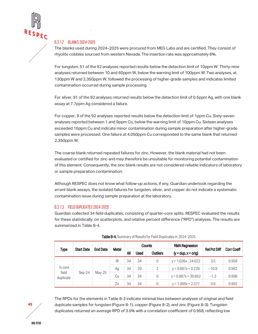
| RSI-3732 44 2 variability and strong reproducibility. Copper duplicates showed an average RPD of -1.3% and a correlation coefficient of 0.998, indicating excellent agreement. Zinc duplicates reported an average RPD of 0.9% with a correlation coefficient of 0.992, also demonstrating strong reproducibility. A slight negative bias was observed in the silver assay duplicates, with duplicate values consistently reporting lower concentrations than the original assays (Figure 8-4). After removal of two outlier pairs, the average RPD remained at approximately -10%, though correlation remained strong at 0.962. The variability in field duplicates generally reflects natural heterogeneity in the deposit rather than systemic analytical errors. Sampling inconsistencies can also cause variability or bias in the RPD data. Figure 8-1. Tungsten Field Duplicate vs. Original, Desert Scheelite 2024-2025. |
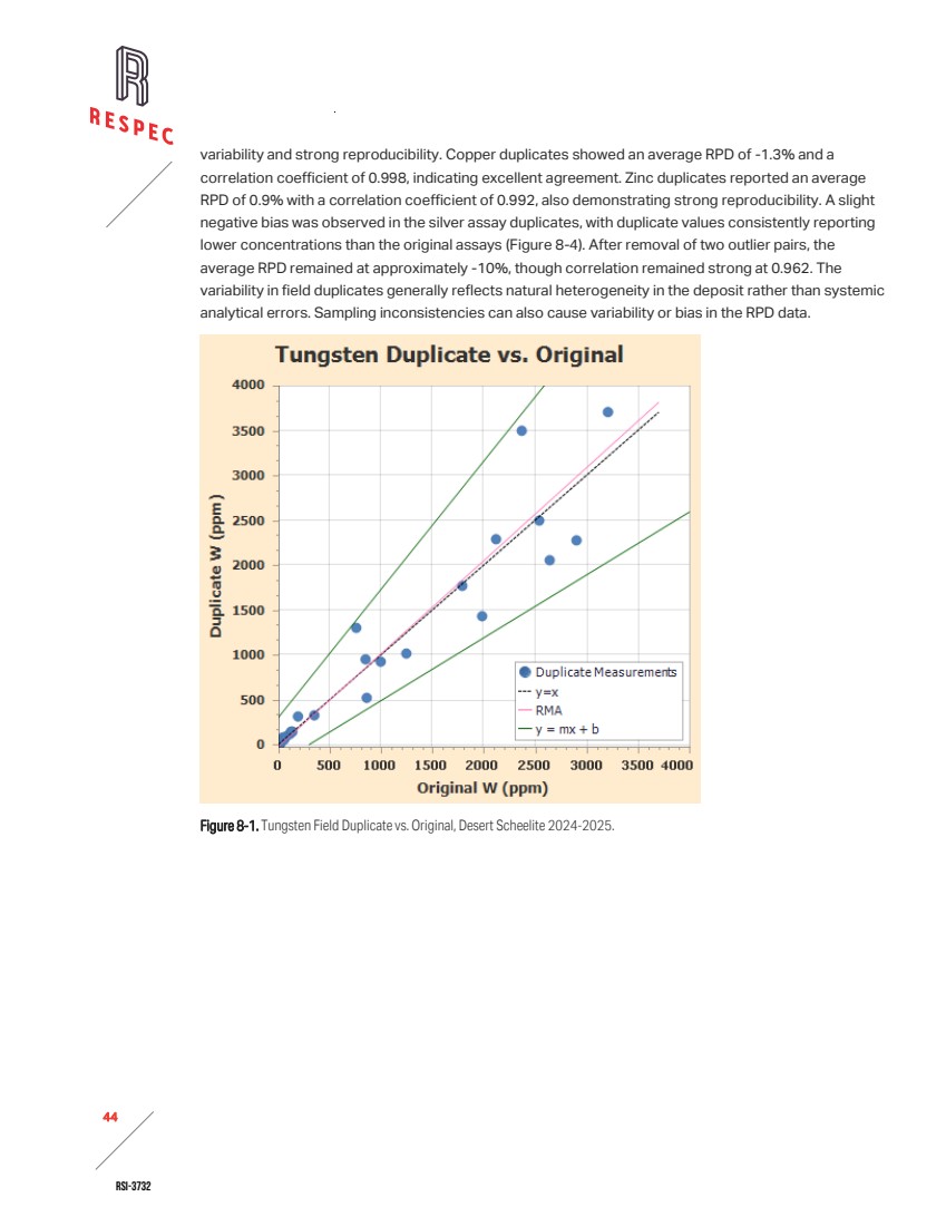
| RSI-3732 45 2 Figure 8-2. Copper Field Duplicate vs. Original, Desert Scheelite 2024-2025. Figure 8-3. Zinc Field Duplicate vs. Original, Desert Scheelite 2024-2025. |
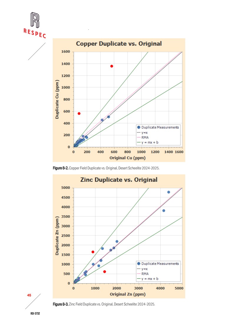
| RSI-3732 46 2 Figure 8-4. Silver Field Duplicate vs. Original, Desert Scheelite 2024-2025. PREPARATION DUPLICATES 2024-2025 Guardian marked 26 coarse duplicate samples in the original sample stream and instructed ALS to prepare duplicates from the coarse rejects of the original sample. RESPEC evaluated these duplicate pairs in the same manner as for field duplicates. A summary of the results is presented inTable 8-5. Table 8-5. Summary of Results for Preparation Duplicates in 2024–2025 Type Start Date End Date Metal Counts RMA Regression Rel Pct Diff Corr Coeff All Used Outliers (y = dup, x = orig) coarse prep dup. Sep-24 May-25 W 26 26 0 y = 0.995x - 3.072 –0.5 0.989 Ag 26 26 0 y = 1.029x + 0.484 2.8 0.988 Cu 26 26 0 y = 0.999x + 20.583 –0.1 1.000 Zn 26 26 0 y = 0.973x + 33.281 –2.7 0.998 The analysis used all samples. No outliers were removed. RMA regression results indicate strong linear relationships between original and duplicate assays, with correlation coefficients ranging from 0.988 to 1.000. RPDs were minimal, ranging from -2.7% to +2.8%, which suggests good analytical precision and negligible bias across all metals. Regression slopes were near unity, further supporting the reproducibility of the preparation duplicate assays. Variability and bias in RPD data tends to decrease at each stage of crushing, such that variability is highest in field duplicates, lower in preparation duplicates, and lowest in pulp duplicates. |
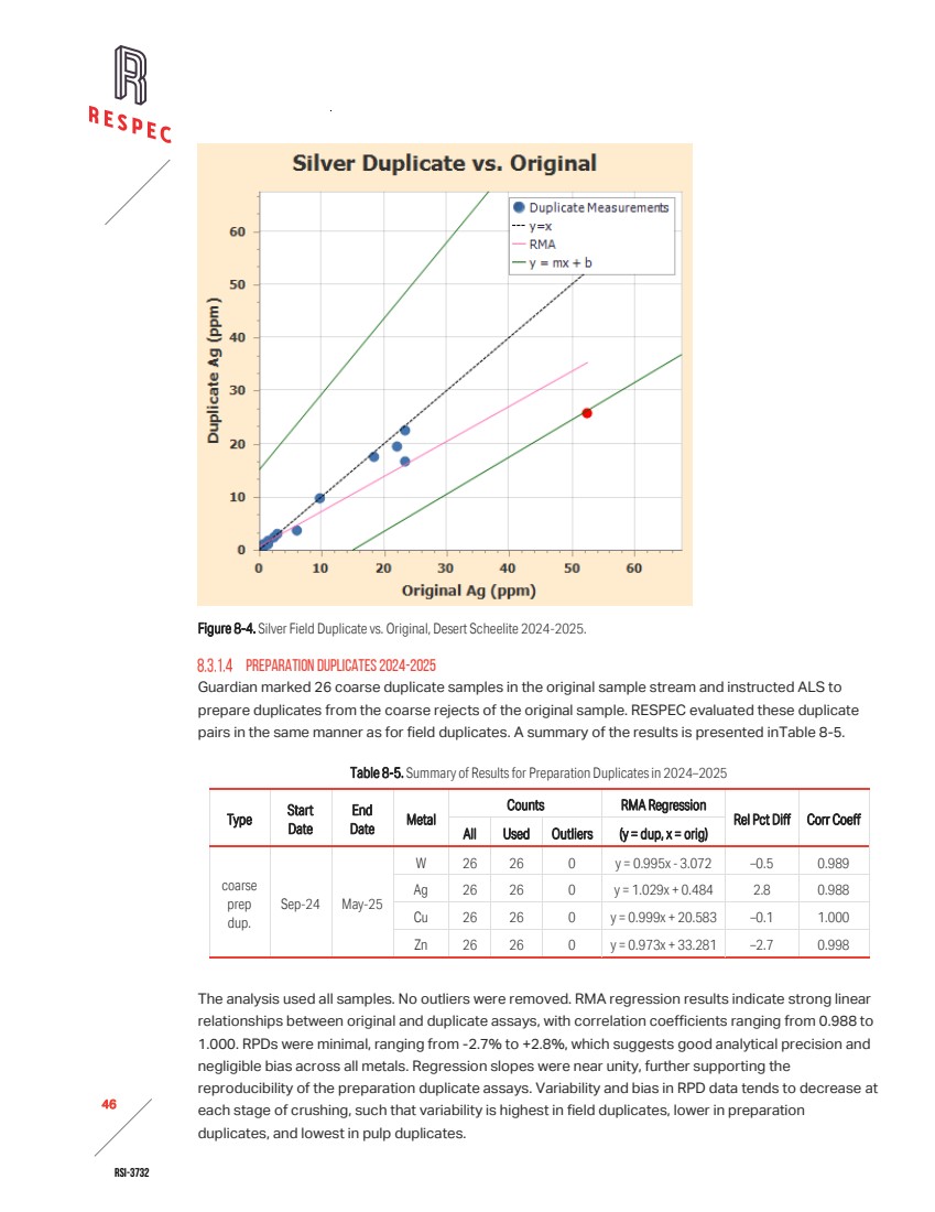
| RSI-3732 47 2 PULP DUPLICATES 2024-2025 Guardian also marked 23 pulp duplicate samples in the original sample stream and instructed ALS to prepare pulp duplicates by splitting the original pulp material. A summary of the results is presented in Table 8-6. Table 8-6. Summary of Results for Pulp Duplicates in 2024-2025 Type Start Date End Date Metal Counts RMA Regression Rel Pct Diff Corr Coeff All Used Outliers (y = dup, x = orig) pulp dup. Sep-24 May-25 W 23 23 0 y = 1.031x + 40.811 3.0 0.979 Ag 23 18 1 y = 0.930x - 0.216 –7.2 0.988 Cu 23 23 0 y = 0.985x - 46.092 –1.5 0.984 Zn 23 23 0 y = 1.033x - 13.139 –0.5 0.995 RESPEC used all samples in the evaluation except for silver. For silver, RESPEC used 18 samples and excluded one outlier. RMA regression results show strong correlations between original and duplicate assays, with correlation coefficients ranging from 0.979 to 0.995. RPDs were low across all metals, ranging from –7.2% to +3.0%. The silver assays exhibited a slight negative bias (RPD = –7.2%), consistent with earlier observations of lower duplicate values at low grades. Overall, the pulp duplicate results demonstrate good analytical precision and minimal bias. SUMMARY OF HISTORICAL QA/QC RESULTS No QA/QC data are available for the original 1970s drilling or for the 2017 program completed by Thor. During the preparation of this resource estimate, no independent assessment of Black Fire’s 2011– 2012 QA/QC program was possible, as the supporting data were not available for review. Although earlier technical reports—Golder [2012] and RES [2018]—describe Black Fire’s QA/QC procedures and results from their campaigns, the absence of underlying data precluded RESPEC from evaluating or verifying the conclusions. As a result, all conclusions by RESPEC regarding data quality for the Thor and Blackfire QA/QC are based solely on the current dataset and accompanying documentation. 8.4 QP OPINION Based on the documentation reviewed, the authors believe that the sample preparation, analytical procedures, and QA/QC protocols implemented by Guardian during the 2024–2025 drilling programs are adequate to support the resource estimate presented in Section 11.0. Guardian’s core handling and sampling followed reasonable standard operating procedures, with consistent application of sample interval selection, protocols, and chain-of-custody measures. ALS conducted sample preparation and analysis using appropriate multi-element and ore-grade methods and performed re-assays using methods with higher detection limits when overlimit assays occurred. Guardian’s QA/QC measures included insertion of certified reference materials, blanks, and field, coarse, and pulp duplicates at statistically meaningful frequencies. The authors evaluated analytical performance using statistics, RPD, and regression analysis. Results for tungsten, copper, and zinc demonstrated acceptable precision and minimal bias across all duplicate types. Silver assays showed slightly elevated variability, particularly at low concentrations, but did not exhibit systematic errors. |
| RSI-3732 48 2 Blank performance was generally acceptable, with isolated failures attributed to sample carryover rather than persistent contamination. CRM results were within expected ranges, with no consistent analytical bias observed. The authors judge that QA/QC results are adequate to support the use of assay data in resource estimation, even though the CRM failure rate was somewhat high for some metals and Guardian’s follow up on CRM and blank failures is not known. The duplicate data sets indicate generally low overall variability, with relative percent differences (RPDs) averaging less than 5% for tungsten, copper, and zinc. These results suggest minimal bias and strong reproducibility between original and duplicate assays. Silver duplicates exhibited a slight negative bias, with duplicate values consistently lower than the originals and an average RPD of approximately ‑10%. The duplicate analyses demonstrate that assay reproducibility is acceptable across the dataset, with only minor bias observed in silver. Black Fire and Thor collected samples using rotary-split RC and core methods. ALS and AAL, both ISO/IEC 17025 accredited, conducted sample prep and analysis. QA/QC protocols included insertion of CRMs and blanks, and check assays confirmed consistency. Although raw QA/QC data from the 2011– 2012 validation program is unavailable, documented procedures provide some confidence in data quality. Due to the absence of QA/QC data, the authors place lower confidence in the Black File and Thor datasets. However, comparative analysis with validated datasets supports the inclusion of select historical data in the mineral resource estimate presented in Section 11.0. Historical drilling data from the 1970s lacks documented sampling protocols and QA/QC records. However, legacy labs such as Skyline Labs held ISO accreditation in later years. The authors place lower confidence in the historical assay data due to the lack of QA/QC data and results. However, as discussed in Section 9.0, data validation through comparative analysis supports the inclusion of select historical data in the estimate of mineral resources presented in Section 11.0. |
| RSI-3732 49 2 9.0 DATA VERIFICATION RESPEC performed a variety of tasks to verify the Desert Scheelite project data. The authors compared the current drilling database to original digital records, which included assay results, collar coordinates, and down-hole orientation surveys. The limited available documentation of the historical drilling data consisted primarily of scanned assay certificates, so RESPEC manually audited a representative portion of the historical data. As detailed in Section 8.3, the authors evaluated the available QA/QC data associated with assays. In addition to the data review, RESPEC conducted a site visit that included direct inspection of the deposit area and Guardian’s operational facility in Hawthorne, Nevada. 9.1 SITE VISITS AND PERSONAL INSPECTIONS Accompanied by Guardian geological personnel, RESPEC geologists visited the Pilot Mountain project on July 8 and 9, 2025, and conducted field examinations of altered and mineralized rocks of the Desert Scheelite, Garnet and Gun Metal deposits. They reviewed core from Desert Scheelite deposit holes PM24-12 and PM24-04 at Guardian’s sample processing facility in Hawthorne, Nevada. The RESPEC geologists also reviewed core sample handling, processing, and storage protocols at the sample-processing and storage facilities, directly observed core handling at a rig drilling into the Garnet deposit, discussed QA/QC, logging procedures, and specific gravity (“SG”) measurements with Guardian personnel, performed GPS collar checks at locations of select holes at drill sites, and collected confirmation samples for assay. 9.2 DRILL-HOLE DATA VERIFICATION Guardian compiles and manages Desert Scheelite deposit drill-hole data in a digital database. The database incorporates information sourced from original field records and laboratory-issued data files. Guardian provided RESPEC with the complete dataset, including original down-hole survey records and collar location documentation. RESPEC obtained the assay certificates for the 2024–2025 drilling program by directly downloading the data from ALS’s secure reporting system. RESPEC’s verification of the Desert Scheelite project data included audits of the assay, down-hole survey, and collar location tables. For each dataset, RESPEC constructed independent comparison tables using original source files and evaluated them against Guardian’s database. Software tools used for this process included Microsoft Excel and the Hexagon MS Torque program. RESPEC and Guardian collaboratively reviewed and resolved any identified discrepancies. The final data tables used for resource estimation incorporated all necessary corrections. 9.2.1 DRILL-HOLECOLLAR LOCATIONS COORDINATE COMPARISONS Guardian’s datum usage has been clearly documented. During the collar audit, RESPEC identified historical records that had previously been transformed to UTM coordinates using the NAD83 datum. To assess the positional implications of this discrepancy, RESPEC performed coordinate comparisons |
| RSI-3732 50 2 between WGS84 and NAD83 datums across all collar locations with ASPS survey records. RESPEC calculated the positional offsets using Euclidean distance between Easting/Northing pairs. As summarized in Table 9-1, the mean offset was 0.1093m with a standard deviation of 0.0006m. These results confirm sub-decimeter consistency across the dataset. Table 9-1. Positional Offset Statistics —WGS84 Versus NAD83 Coordinate Comparison Offset Statistic Value (m) Minimum Offset 0.1087 Maximum Offset 0.1099 Mean Offset 0.1093 Median Offset 0.1097 Standard Deviation 0.0006 Number of Collar Points 70 Given the minimal positional difference and the consistent use of WGS84 in modern data acquisition, all coordinates in this report are retained in UTM WGS84. This approach ensures internal consistency and avoids unnecessary transformation artifacts. Based on the results of the comparison, the positional tolerance is well within acceptable limits. GPS COLLAR CHECKS During the July 2025 Pilot Mountain project site visit, RESPEC geologists took GPS measurements on eight drill pads, or suspected drill pads, to spot-check coordinates in Guardian’s collar tables (Table 9-2). Field measurements and collar coordinates in the database were taken in NAD83 meters for comparison in Table 9-2. RESPEC found direct evidence of drill holes—concrete plugs, drill pipe, or open holes—at six sites. Four sites had drill-hole identifications marked in some way, of which two were Guardian holes. Two sites were suspected or determined to be pads using less direct evidence, such as the presence of cuttings, or level spots likely constructed for no other reason than drilling. Where no drill-hole identification was found at the site, the closest drill collar in the database was used for comparison. Table 9-2 gives the best-case comparisons (although unconfirmed). The RESPEC geologists used a Garmin eTrex - Legend non-differential GPS to measure coordinates at the drill sites and pads. The Garmin website indicates that the eTrex - Legend device is accurate to within “3-5m (10-16ft), 95% typical with DGPS corrections, <15m (49ft) RMS, 95% typical.” The overall results were good for all holes and suspected pads, drill sites, and inferred collar locations. All measured coordinates were within an expected range of the non-differential GPS accuracy when compared to the database coordinates. The largest discrepancy was 3.6m for northings and eastings. Differences up to 6.4m was noted for elevations, although GPS readings in the vertical sense tend to be less accurate. |
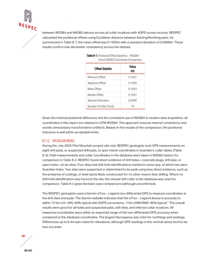
| RSI-3732 51 2 Table 9-2. Verification GPS Checks of Drill Collars at the Pilot Mountain Project (Page 1 of 2) Location Drill-Hole ID Description RESPEC GPS Collar Coordinates Guardian Database Collar Coordinates Difference - RESPEC vs Database Easting (m) Northing (m) Elevation (m) Easting (m) Northing (m) Elevation (m) Easting (m) Northing (m) Elevation (m) Desert Scheelite - Test pit DSDD-02? Old wood stake in ground with no apparent markings or concrete plug 424,040 4,248,272 1,955 424,040 4,248,273.41 1,956.2 0 1.41 1.2 Desert Scheelite - Test pit DSDD-03 2ft diameter concrete plug with hole ID carved into surface 424,083 4,248,286 1,954 424,083 4,248,288.78 1,956.7 0 2.78 2.7 Desert Scheelite - Test pit 87 Rebar with orange plastic cap possibly embedded in concrete; Adjacent orange pin flag marked with '87' 424,124 4,248,289 1,955 424,125 4,248,287.26 1,957.923 1 –1.74 2.923 Desert Scheelite - Near trench west of test pit PM24- 33 1½in x 1½in wood stake marked with hole ID, proposed hole ID and dip of hole; Painted red and embedded in concrete plug 423,906 4,248,252 1,989 423,908 4,248,248.73 1,990.148 2 –3.27 1.148 Desert Scheelite - South of test pit PM24- 17 Same 1½in x 1½in wood stake embedded in concrete plug as PM24-17; Also has aluminum tag at base of stake marked with hole ID 424,305 4,248,331 1,945 424,307 4,248,328.79 1,948.363 2 –2.21 3.363 Good Hope DH-81 5½in-diameter casing extending 8in to 10in above ground surface on old drill pad. 423,916 4,249,462 1,953 423,917 4,249,458.4 1,957.8 1 –3.60 4.8 |
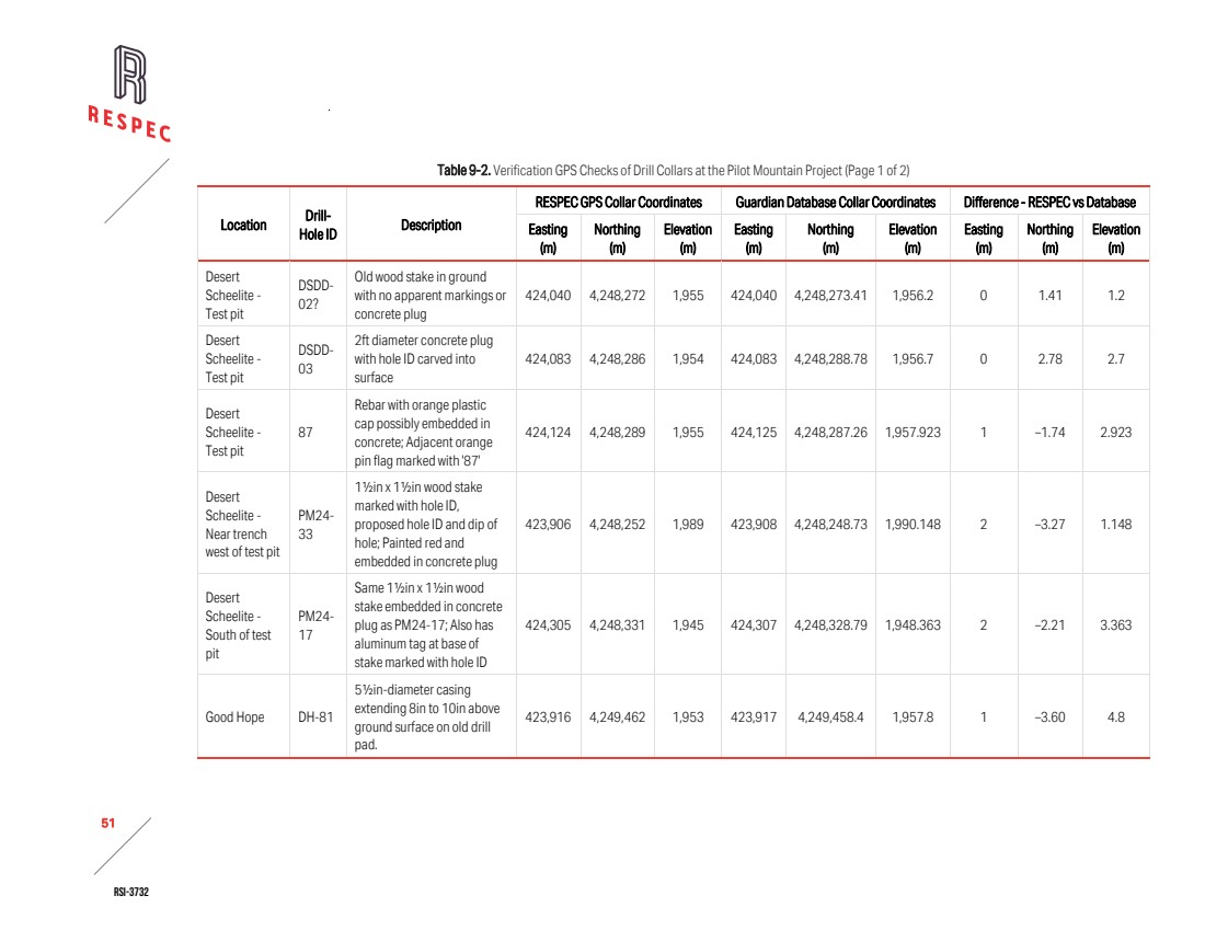
| RSI-3732 52 2 Table 9-2. Verification GPS Checks of Drill Collars at the Pilot Mountain Project (Page 2 of 2) Location Drill-Hole ID Description RESPEC GPS Collar Coordinates Guardian Database Collar Coordinates Difference - RESPEC vs Database Easting (m) Northing (m) Elevation (m) Easting (m) Northing (m) Elevation (m) Easting (m) Northing (m) Elevation (m) Garnet - At site of Guardian drill hole PMGR25- 119 in progress GR-070? Metal casing with metal cap likely created on-site with cutting torch; Hole not marked, but GR-070 is the only drill hole with coordinates that are reasonable 422,230 4,249,455 2,176 422,233 4,249,452 2,175.7 3 –3.00 –0.3 Gun Metal GM-31 Metal cap with handle over open hole; Aluminum tag marked with hole ID attached to handle of cap with wire tie or bailing wire; Buried over time with 3in to 4in of loose sediment 422,447 4,248,861 2,143 422,448 4,248,858.6 2,149.4 1 –2.40 6.4 Note: Coordinates measured in UTM NAD 83 Zone 11 meters projection |
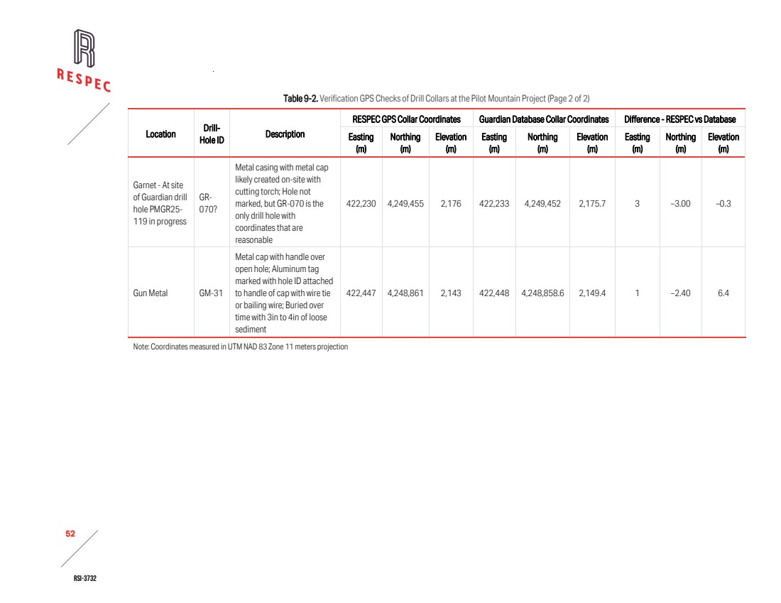
| RSI-3732 53 2 9.2.2 DOWN-HOLE SURVEYS Guardian provided RESPEC with digital copies of the raw survey data in Excel format for each drill hole. RESPEC used these files to verify the down-hole orientation data stored in Guardian’s database. RESPEC did not identify any discrepancies. No down-hole orientation data were available for the historical drill holes. As a result, survey verification was limited to the 2024–2025 dataset. No assessment of deviation parameters or survey accuracy was possible for earlier drilling campaigns. 9.2.3 ASSAYS AUDIT OF ASSAYS Using digital data files downloaded directly from ALS, RESPEC audited tungsten, silver, copper, and zinc assay values from Guardian’s drilling programs in Guardian’s database. RESPEC used scanned original certificates from Rocky Mountain Geochemical, Skyline Labs, and Southwestern Assayers and Chemists provided by Guardian to verify historical drill-hole assays in the historical drill database. RESPEC identified minor discrepancies, primarily in historical silver, copper, or zinc assays where sample intervals were recorded as nil values in the database but reported as below detection limit on the original certificates. In addition, RESPEC discovered that the conversion factor from elemental tungsten to tungsten trioxide (WO₃) was inconsistently applied across the assay records. RESPEC resolved all discrepancies in consultation with Guardian personnel. During the audit of the historical tungsten assay dataset, RESPEC noted that the analytical method employed by UCC and Duval was colorimetry, as indicated on original certificates from laboratories active during the 1970s, including Skyline. Colorimetric analysis was a routine and widely accepted technique for tungsten determination during that period. Although no QA/QC data from the original campaigns are available, RESPEC chose to use select historical colorimetric data in the current resource model based on the corroborating evidence from comparative analyses (described below). ASSESSMENT OF HISTORICAL ASSAYS To assess the compatibility of the assay datasets generated by different operators, RESPEC constructed box plots and cumulative probability plots (“CPP”) for WO₃ values grouped by company. This method enabled visual comparison of distribution characteristics, including grade ranges, detection limits, and population continuity (Figure ). |
| RSI-3732 54 2 Figure 9-1. Box Plots of WO3 Data Sorted by Company. RESPEC evaluated the Guardian, Duval, and UCC WO₃ datasets to assess their compatibility and impact on resource estimation. As summarized in Table 9-3, Guardian and Duval report broadly similar grade distributions, with mean values near 0.12% WO₃ and medians around 0.02% WO3. Both datasets show high variability, strong skewness, and numerous outliers. This variability results from the broader sampling coverage that Guardian and Duval conducted to capture the full range of WO₃ grades across the deposit. In contrast, the UCC dataset reflects a higher-grade population with a mean of 0.31% WO3, a median of 0.27% WO3, and shows tighter clustering with fewer outliers. The UCC distribution appears less skewed and more stable, but the smaller sample size and higher detection limit reduce its direct comparability to Guardian and Duval. At the upper end of the distribution, Guardian reports slightly higher WO₃ values, which RESPEC attributes to the use of XRF analysis for overlimit assays during the 2024–2025 drilling program. Overall, Guardian and Duval provide a statistically compatible foundation for resource estimation, while UCC contributes valuable higher-grade context within its restricted population. Table 9-3: WO3 Population Statistics by Company Company Number of Samples Min Max Mean Median Co. of Variation Skewness Kurtosis Min Non-Outlier Max Non-Outlier Guardian 2,174 0.00063 3.04 0.121 0.021 2.05 5.18 40.86 0.0006 0.34 Duval 1,964 0.0003 2.84 0.115 0.021 1.89 4.05 27.93 0.0003 0.34 UCC 516 0.02 1.93 0.312 0.270 0.78 1.77 6.05 0.020 0.82 The population distributions for Duval, Guardian, and UCC show broadly similar grade profiles (Figure 9-2). Although the UCC dataset represents a smaller and more restricted population, its cumulative curve breaks at approximately 0.2% WO3 with a slope angle that closely matches those observed in the |
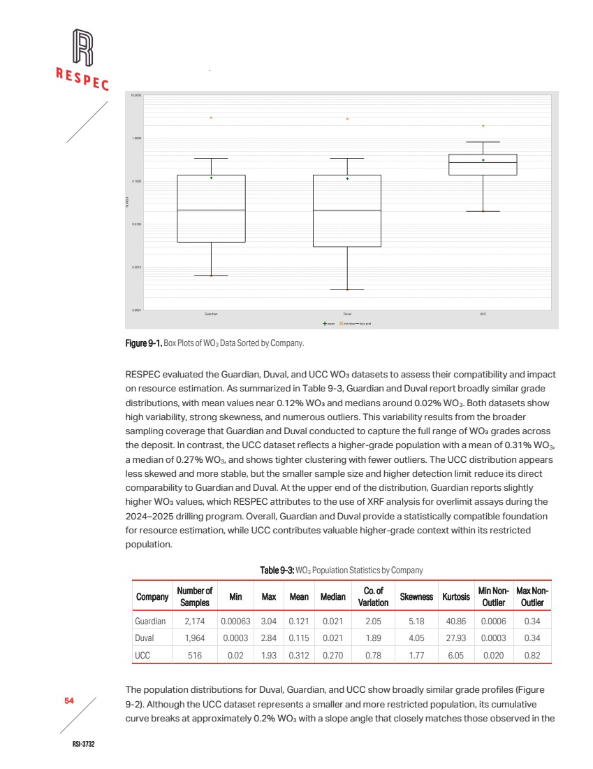
| RSI-3732 55 2 Duval and Guardian datasets. Between approximately 10% and 90% of the data, the slope and spacing of the curves remain consistent across all three operators, indicating comparable grade populations despite differences in dataset size and detection limits. At the upper end of the distribution, Guardian’s dataset extends to slightly higher WO₃ values, which RESPEC attributes to the use of XRF analyses for overlimit assays during the 2024-2025 drilling program. Figure 9-2. Cumulative Probability Plots of WO3 Assays by Company—Guardian in Blue, Duval in Green, and UCC in Red. To further assess the compatibility of the historical and modern assay datasets, RESPEC performed a comparison interpolation on a spatially constrained subset of the data. The analysis indicated that the historical-only dataset returned WO₃ grades approximately 17% higher than the Guardian-only dataset. The overall grade populations appear broadly similar, but the limited number of lower grade samples, particularly in the UCC dataset, combined with selective sampling of mineralized intervals and higher detection limits, likely placed greater emphasis on higher grades in the interpolation. Another contributing factor is the drilling orientation of the historical holes. The vertical historical holes intersected the subvertical deposit at low angle oblique intercepts, which likely exaggerated the apparent thickness of higher-grade zones. In contrast, Guardian designed its drilling program with angled holes to approximate true thickness and reduce geometric bias. RESPEC considers the observed difference to reflect sampling population effects and drilling geometry rather than a systematic analytical bias, although RESPEC cannot entirely rule out alternative explanations. CONFIRMATION SAMPLES RESPEC geologists collected field grab samples from outcropping mineralized zones within the Desert Scheelite and Gunmetal deposits. They obtained these samples to provide independent confirmation of mineralization style and tenor, recorded the sample locations using a handheld GPS, and made basic lithologic descriptions of the samples at the time of collection. The samples were submitted to ALS for multi-element analysis (Table 9-4). |
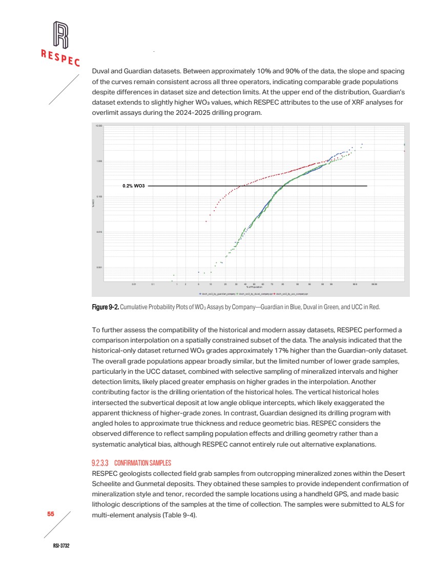
| RSI-3732 56 2 Table 9-4. Assay Results from Independent Confirmation Testing of Field Grab Samples Sample ID Location Description RESPEC GPS Sample Location W Ag Pb Zn Cu Mo Easting Northing Elevation (ppm) (ppm) (ppm) (ppm) (ppm) (ppm) DS-01 Desert Scheelite - Test pit Oxidized garnet skarn with abundant black, dark brown and orange FeOx; Cu stain up dip in possible E-W, 70° north-dipping structure 424,033 4,248,259 1,960 1,360 25.6 15.0 13,150 7,600.0 213.0 DS-02 Desert Scheelite - Test pit Oxidized garnet skarn - Mixed garnet-rich, weakly to moderately oxided skarn and strongly oxidized rock with dark brown to black FeOx; To south of DS-01 across quartz monzonite 'dike' 424,037 4,248,261 1,959 3,510 3.24 42.3 11,300 5,440.0 382.0 DS-03 Desert Scheelite - Trench Sample across 1m- to 2m-wide [possible] fault-breccia zone with abundant silicification, quartz and calcite veins and black FeOx stain; Within moderately to strongly oxidized skarn with high garnet content 423,920 4,248,246 1,986 760 1.8 47.8 654 57.5 36.6 DS-04 Gun Metal - In open cuts at east end of series of cuts and underground workings Grab sample from skarn cobbles and boulders in cut; Contains 80% to 90% garnet No GPS coordinates of location 2,780 3.33 4.6 1,170 26.0 27.1 DS-05 Gun Metal - In open cut in central portion of series of cuts and underground workings Skarn containing 80% to 90% garnet and abundant quartz veins 422,241 4,249,031 2,206 1,430 0.33 6.1 189 17.9 64.5 Note: Coordinates measured in UTM NAD 83 Zone 11 meters projection |
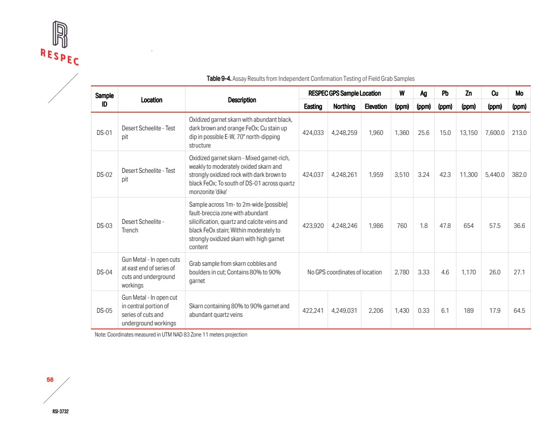
| RSI-3732 57 2 Independent analysis of the grab samples confirmed the existence of the tungsten and base metal mineralization that occurs at the Pilot Mountain project. Assay results were consistent with the observed lithologic associations, providing qualitative support for the geological interpretations and mineralization model. 9.3 LIMITATIONS The verification of the historical data was subject to several limitations. The lack of down-hole survey records for historical drill holes, prevented RESPEC from validating their orientation parameters or deviation profiles. In addition, incomplete or missing assay certificates from early campaigns, limited RESPEC’s ability to confirm original analytical results for some intervals. Where original documentation was unavailable, RESPEC necessarily relied on database entries. RESPEC documented these limitations and considered them in the assessment of the reliability of the historical data and in decisions regarding the use of that historical data in the estimate of mineral resources presented in Section 11.0. 9.4 ADEQUACY OF DATA In the authors’ opinions, the data reviewed and verified during the audit are adequate for use in mineral resource estimation and disclosure under S-K 1300. Limitations in the historical dataset, which include incomplete down-hole survey records and inconsistent assay documentation, were identified and addressed through comparative analysis. Confidence is lower in areas influenced predominantly by pre‑Guardian drilling, particularly where vertical holes intersect steeply dipping mineralized zones. These configurations may have introduced local bias toward wider zones of estimated higher grades. However, comparative analysis supports the overall inclusion of this historical data in the resource estimate, with the limitations noted. Guardian’s dataset generated during the 2024-2025 drilling program meets current industry standards and supports the reliability of the resource model. Guardian and RESPEC integrated the historical data with appropriate caution. While acknowledging that there is some risk associated with the estimated volume of higher-grade material, the resulting database is suitable for technical reporting, resource estimation, and regulatory compliance. Assays determined by colorimetric methods during the 1970s drilling campaigns are considered acceptable for inclusion in the mineral resource estimate. Although these methods are less precise than modern instrumental techniques, colorimetry was a recognized and widely used procedure for tungsten analysis at the time. Partial assay certificates recovered by Guardian provide traceability, and one of the original laboratories, Skyline Labs, was later accredited to ISO 9001 and ISO/IEC 17025 standards. Although no QA/QC data from the original campaigns are available, the corroborating evidence from comparative analyses justifies the use of select historical colorimetric data in the current resource model. |
| RSI-3732 58 2 10.0 MINERAL PROCESSING AND METALLURGICAL TESTING The following summary of metallurgical test work and recovery methods is based on a memorandum prepared by Samuel Engineering (“Samuel”) [Samuel, 2025], an external consultant retained by Guardian. RESPEC has reviewed the memorandum for relevance and consistency with the mineralization style observed at the Desert Scheelite deposit. RESPEC has summarized the information provided in Samuel’s report and, although the underlying test procedures and results were not independently verified, RESPEC has reviewed and accepted the material presented in this section of the Technical Report Summary. 10.1 ANALYTICAL PROCEDURES To characterize mineralogy, evaluate process response, and develop preliminary beneficiation flowsheets on material from the Desert Scheelite, Garnet, and Gunmetal deposits, metallurgical test work has been conducted in multiple laboratory campaigns. Amdel Laboratories (“Amdel”) in Perth, Australia completed testing under the supervision of Coffey Mining, the Guangdong Institute of Resources Comprehensive Utilization in Guangzhou, China (“the Guangdong Institute”), and the Guangzhou Research Institute of Non-ferrous Metals (“GZRINM”), Guangzhou, China. Collectively, the programs included mineralogical characterization, gravity separation, magnetic separation, and flotation testing. Amdel established a preliminary grind size for scheelite and performed gravity separation and rougher flotation testing. The Guangdong Institute performed quantitative mineralogy and developed two flotation flowsheets, one incorporating a sulfide pre-float and one without. Ancillary test work included magnetic separation for impurity control, head assays, tailings settling, and water quality evaluation for process design inputs. 10.2 MINERALIZATION Amdel prepared the composite samples used for metallurgical testing from material identified as representative of the Desert Scheelite, Garnet, and Gunmetal deposits. They assembled the composites to reflect the principal mineralization styles, with scheelite confirmed as the dominant tungsten mineral accompanied by minor sulfides. While the test work indicates metallurgical behavior consistent with the observed mineral assemblages in the Desert Scheelite deposit, detailed documentation of the composite selection, including spatial distribution, lithologic proportions, and grade variability, was not available for RESPEC to review. As such, RESPEC cannot fully confirm the representativeness of the metallurgical samples relative to the full range of mineralization within the Desert Scheelite deposit. RESPEC recommends that Guardian conduct additional metallurgical sampling across distinct mineralized domains to verify response variability and ensure that future test work captures the full range of process characteristics present in the deposit. 10.3 LABORATORIES 10.3.1 AMDEL LABORATORIES Amdel is part of Bureau Veritas Minerals, an internationally recognized analytical group operating under an ISO 9001 quality management system and accredited by the National Association of Testing Authorities (NATA) to ISO/IEC 17025 for selected analytical and assay methods. These certifications |
| RSI-3732 59 2 verify technical competence, quality control procedures, and the traceability of analytical results. Amdel acted as an independent commercial laboratory and reported directly to Coffey Mining. No relationship or affiliation existed between Amdel and Guardian Metals other than the provision of contracted laboratory services. 10.3.2 GUANGDONG INSTITUTE OF RESOURCES COMPREHENSIVE UTILIZATION The Guangdong Institute operates as a state-affiliated research and testing organization. Although formal accreditation records were not publicly verified, comparable institutes in China typically maintain China National Accreditation Service (“CNAS”) accreditation consistent with ISO/IEC 17025 requirements for mineral assay and materials testing. The Guangdong Institute performed flotation, gravity, and magnetic separation testing and provided head assay and concentrate analyses. RESPEC understands that the Guangdong Institute acted as an independent service provider to Thor, with no reported ownership or financial interest in the Pilot Mountain Tungsten Project. 10.3.3 GUANGZHOU RESEARCH INSTITUTE OF NON-FERROUS METALS GZRINM reviewed prior metallurgical test work and performed confirmatory assessments of gravity and flotation performance. GZRINM serves as a national-level research institute within China’s non-ferrous metals industry, offering analytical, metallurgical, and pilot-scale testing services. While specific accreditation details were not confirmed, institutes of this type generally operate under CNAS or equivalent quality management systems aligned with ISO/IEC 17025. GZRINM acted as an independent technical consultant and laboratory. The authors know of no conflicts of interest or related-party relationships between GZRINM and Guardian. 10.4 TESTING RESULTS AND RECOVERY ESTIMATES Amdel confirmed scheelite as the sole tungsten-bearing mineral and conducted liberation studies that established a target grind size of 106µm. Gravity separation using Wilfley tabling followed by Mozley cleaning achieved an upgrade ratio of approximately 27:1, recovering about 72.5% of contained tungsten to 1.7% of the feed mass. Subsequent rougher flotation tests, performed at grind sizes of P80 106µm and P80 45µm, including a conceptual circuit that recycled gravity middlings and tails, achieved up to 90.7% WO₃ recovery. However, concentrate grades were low due to calcium gangue carryover. The Guangdong Institute conducted rougher flotation at approximately 70% passing 75µm produced rougher concentrates grading 3.92% WO₃ at 76.1% recovery. Multi-stage heated cleaning yielded final scheelite concentrates grading 66.9 to 68.2% WO₃ at recoveries of 71 to 74%, with impurity levels meeting commercial specifications. GZRINM reviewed and corroborated the gravity plus flotation process concept and recommended reagent optimization, cleaner circuit configuration, and potential recovery of additional tungsten from magnetic products by spirals or tabling. |

| RSI-3732 60 2 10.5 CONCLUSIONS ON DATA ADEQUACY RESPEC offers no conclusions regarding the content in this section and presents the summary of work completed for informational purposes only. The conclusions below are paraphrased from Samuel [2025]. Samuel concluded that the metallurgical test work completed to date provides a reasonable preliminary understanding of the mineralogy and process response of the Desert Scheelite deposit. Scheelite was confirmed as the dominant tungsten mineral, and bench scale gravity and flotation tests supported by quantitative mineralogy demonstrated recoveries exceeding 70% WO₃ at commercially saleable concentrate grades. The mineralization is amenable to conventional gravity and flotation processes commonly applied to scheelite deposits and establish a preliminary basis for assuming reasonable metallurgical recoverability in the context of an initial estimate of mineral resources. Samuel also observed that the current metallurgical dataset remains limited in spatial coverage and does not fully document sample representativeness or variability across the mineralized domains of the deposit. Accordingly, the results were considered adequate only for use in preliminary metallurgical assumptions supporting an initial estimate of mineral resources, but insufficient for detailed process design or economic analysis. Samuel recommended additional variability testing, reagent optimization, and confirmatory work on domain specific composites to validate recovery factors and establish robust process parameters for future resource and reserve estimation stages. |

| RSI-3732 61 2 11.0 MINERAL RESOURCE ESTIMATES This estimate of mineral resources for the Pilot Mountain Tungsten Project was completed for disclosure in accordance and reporting requirements outlined in the United States Securities and Exchange Commission’s (“SEC”) Modernized Property Disclosure Requirements for Mining Registrants as described in Subpart 229.1300 of Regulation S-K, Disclosure by Registrants Engaged in Mining Operations (S-K 1300) and Item 601 (b)(96) Technical Report Summary. RESPEC completed the modeling and estimation of the mineral resources for the Desert Scheelite deposit on October 29, 2025. The effective date of the resource estimate is December 01, 2025, when pit optimizations were applied for resource reporting. RESPEC is independent of Guardian and its Pilot Mountain Tungsten Project by the definitions and criteria outlined in S-K 1300. There is no affiliation between RESPEC and Guardian or its Pilot Mountain Tungsten Project except that of independent consultant/client relationships. As of the date of this report, RESPEC is not aware of any unusual environmental, permitting, legal, title, taxation, socio-economic, marketing, or political factors that may materially affect the estimate of Desert Scheelite mineral resources. SEC definitions and requirements relevant to the disclosure of mineral resources are given below, with the SEC’s exact text in italics: Disclosure of mineral resources… must be based on and accurately reflect information and supporting documentation prepared by a qualified person. A mineral resource is a concentration or occurrence of material of economic interest in or on the Earth's crust in such form, grade or quality, and quantity that there are reasonable prospects for economic extraction. A mineral resource is a reasonable estimate of mineralization, taking into account relevant factors such as cut-off grade, likely mining dimensions, location or continuity, that, with the assumed and justifiable technical and economic conditions, is likely to, in whole or in part, become economically extractable. It is not merely an inventory of all mineralization drilled or sampled. When determining the existence of a mineral resource, a qualified person must: » Be able to estimate or interpret the location, quantity, grade or quality continuity, and other geological characteristics of the mineral resource from specific geological evidence and knowledge, including sampling; and » Conclude that there are reasonable prospects for economic extraction of the mineral resource based on his or her initial assessment. At a minimum, the initial assessment must include the qualified person's qualitative evaluation of relevant technical and economic factors likely to influence the prospect of economic extraction to establish the economic potential of the mining property or project. |
| RSI-3732 62 2 In addition: » The technical report summary submitted by the qualified person to support a determination of mineral resources must describe the procedures, findings and conclusions reached. » When determining mineral resources, a qualified person must subdivide mineral resources, in order of increasing geological confidence, into inferred, indicated, and measured mineral resources. An inferred mineral resource is that part of a mineral resource for which quantity and grade or quality are estimated on the basis of limited geological evidence and sampling. The level of geological uncertainty associated with an inferred mineral resource is too high to apply relevant technical and economic factors likely to influence the prospects of economic extraction in a manner useful for evaluation of economic viability. Because an inferred mineral resource has the lowest level of geological confidence of all mineral resources, which prevents the application of the modifying factors in a manner useful for evaluation of economic viability, an inferred mineral resource may not be considered when assessing the economic viability of a mining project, and may not be converted to a mineral reserve. For inferred mineral resources, a qualified person: (1) Must have a reasonable expectation that the majority of inferred mineral resources could be upgraded to indicated or measured mineral resources with continued exploration; and (2) Should be able to defend the basis of this expectation before his or her peers. An Indicated Mineral Resource is that part of a mineral resource for which quantity and grade or quality are estimated on the basis of adequate geological evidence and sampling. The level of geological certainty associated with an indicated mineral resource is sufficient to allow a qualified person to apply modifying factors in sufficient detail to support mine planning and evaluation of the economic viability of the deposit. Because an indicated mineral resource has a lower level of confidence than the level of confidence of a measured mineral resource, an indicated mineral resource may only be converted to a probable mineral reserve. A Measured Mineral Resource is that part of a mineral resource for which quantity and grade or quality are estimated on the basis of conclusive geological evidence and sampling. The level of geological certainty associated with a measured mineral resource is sufficient to allow a qualified person to apply modifying factors, as defined in this section, in sufficient detail to support detailed mine planning and final evaluation of the economic viability of the deposit. Because a measured mineral resource has a higher level of confidence than the level of confidence of either an indicated mineral resource or an inferred mineral resource, a measured mineral resource may be converted to a proven mineral reserve or to a probable mineral reserve. Modifying Factors are the factors that a qualified person must apply to indicated and measured mineral resources and then evaluate in order to establish the economic viability of mineral reserves. A qualified person must apply and evaluate modifying factors to convert measured and indicated mineral resources to proven and probable mineral reserves. These factors include, but are not restricted to: Mining; processing; metallurgical; infrastructure; economic; marketing; legal; environmental compliance; plans, negotiations, or agreements |
| RSI-3732 63 2 with local individuals or groups; and governmental factors. The number, type and specific characteristics of the modifying factors applied will necessarily be a function of and depend upon the mineral, mine, property, or project. RESPEC conducted work that included assessment of the recoverability of valuable minerals, evaluation of potential markets for recovered mineral forms, estimation of mining costs, development of a preliminary pit configuration, and analysis of milling and processing costs. These initial evaluations were completed to a level that demonstrates a “prospect of economic extraction.” While the work does not establish reserves or reach feasibility standards, it is sufficient to support the declaration of mineral resources. 11.1 DATABASE RESPEC staff audited the Pilot Mountain drilling database in 2025 and finalized the database used for mineral resource estimation on October 20, 2025. A plan map showing drill-hole collar locations and resource outline for the Desert Scheelite deposit is presented in Figure 7-1 in Section 7.3. The database has 7,730 assay records accepted as usable for estimation. RESPEC excluded a total of 292 assay records, all originating from nine drill holes, due to long composited samples and selectively sampled intervals that did not align with Guardian’s drill assays. RESPEC removed these records from the resource database to ensure that only reliable data contributed to the resource estimation. Of the accepted records, 3,814 have elemental tungsten assays, 5,921 have WO3 assays, 5,342 (69% of intervals with W and/or WO3 assays) have silver assays, 6,814 (88%) have copper assays, and 5,098 (65%) have zinc assays. Table 11-1 presents descriptive statistics of all data in the audited database that was imported into MS Torque for modeling and resource estimation in MinePlan. The database also contains logged lithology, alteration, and oxidation. RESPEC used all acceptable drilling data in the estimate, but RESPEC only audited the collar locations, down-hole surveys, and the tungsten, silver, copper, and zinc analyses. |
| RSI-3732 64 2 Table 11-1. Desert Scheelite Resource Database Descriptive Statistics—For All Accepted Sample Data Only Field Valid Minimum Maximum Mean Median Std. Devn. Co. of Variation Unit From 7,730 0 371.90 m To 7,730 0.5 374.90 m Length 7,730 0.04 187.6 2.952 1.8 m W 3,814 0 2.3 0.09 0.021 0.148 1.656 % WO3 5,921 0 3.04 0.132 0.029 0.229 1.731 % Ag 5,342 0.034 1,749.65 8.742 1.028 41.241 4.718 ppm Cu 6,814 0 5.02 0.058 0.012 0.209 3.613 % Zn 5,098 0 25.25 0.209 0.027 0.805 3.855 % 11.2 GEOLOGIC MODEL Guardian provided RESPEC with a comprehensive geologic model built from Guardian’s and historical geological logging data. The model includes geologic solids constructed in Leapfrog Geo that were applied to code the block model. In the same manner, an oxidation model was developed from Guardian’s and historical logging data, with oxidation surfaces generated in Leapfrog Geo and used to code the block model. The geologic basis for the model is described in Section 6.0, and representative schematic cross-sections are presented in Figure 11-1. 11.3 MINERAL DOMAINS Using the geologic model as a control, RESPEC interpreted domains of tungsten, silver, copper, and zinc based on sample assays. RESPEC defined the domains according to population breaks on CPPs of each metal separately. The summary of high- and low-grade domain grade ranges determined for each metal is provided in Table 11-2. Table 11-2. Grade Ranges of Tungsten, Silver, Copper, and Zinc Domains Determined from CPPs Domain % WO3 ppm Ag % Cu % Zn Low-grade 0.02 - 0.2 2.0 - 15.0 0.02 - 0.6 0.01 - 1.8 High-grade > 0.2 > 15.0 > 0.6 > 1.8 Higher grade tungsten mineralization within the Desert Scheelite deposit is concentrated in three principal zones. The hanging wall zone occurs within skarn adjacent to the hornfels contact. A mid‑deposit zone is hosted within skarn and marble. The footwall zone is hosted within skarn and marble near the quartz monzonite intrusion. These elevated grades show a strong correlation with skarn alteration developed in marble host rocks, while hornfelsed clastic sedimentary units display weaker associations with tungsten mineralization. The quartz monzonite intrusive does not exhibit endoskarn development and is not mineralized. |
| RSI-3732 65 2 RESPEC constructed the grade domains in Leapfrog Geo using interval selection, which enabled the low‑grade and high‑grade domains to snap to the appropriate drill intercepts. To capture stratigraphic controls on mineralization and to model the domains consistently, RESPEC performed the interval selection along 25m‑spaced, north–south‑oriented cross‑sections. Tungsten mineralization was modeled first. The resulting single set of grade domains provided the basis for defining the corresponding low‑grade silver, copper, and zinc domains. Using the same interval‑selection methodology described above, RESPEC constructed high‑grade domains for tungsten, silver, copper, and zinc. Although RESPEC identified and modeled distinct grade populations, RESPEC applied no separate high‑grade domains in the final resource estimation. To ensure appropriate control of grade estimation within the resource model, RESPEC managed grade continuity according to variogram analyses and the influence of the high‑grade sample population by the application of appropriate estimation parameters, including strong high-grade search restrictions. An example of the geology and the tungsten mineral domain within the Desert Scheelite deposit is illustrated in Figure 11-1. |

| RSI-3732 66 2 Figure 11-1. North-South Cross-Section 424305E Showing Tungsten Mineral Domains and Geology. |
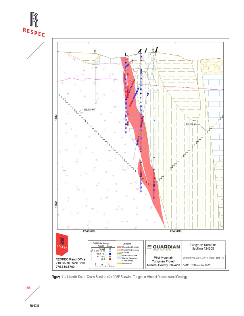
| RSI-3732 67 2 11.4 SPECIFIC GRAVITY Black Fire and Guardian collected a total of 892 specific gravity measurements on drill-core samples using the water‑immersion method. RESPEC does not know whether Black Fire’s samples were wax coated during testing. Guardian’s samples were coated with wax. RESPEC evaluated the density dataset both collectively and by logged rock type. Review of measured densities by oxidation type established that oxidation effects on density were minimal. To reduce the influence of outliers and better represent the central tendency of the dataset, RESPEC assigned the median values to the lithologic units in the block model rather than assigning the arithmetic means. The density statistics associated with the different lithologies and their assigned density values are summarized in Table 11-3. Table 11-3. Density Statistics and Values Applied to the Different Lithologies in the Block Model Lithology Valid Mean Median Std. Dev. CV Minimum Maximum Density Assigned in Model Units Marble 169 2.556 2.680 0.576 0.225 0.000 3.350 2.68 g/cm3 Skarn 318 2.864 2.940 0.345 0.121 1.717 3.717 2.94 g/cm3 Hornfels 163 2.635 2.660 0.531 0.198 0.000 3.569 2.66 g/cm3 Quartz Monzonite 134 2.579 2.596 0.108 0.042 2.070 2.714 2.59 g/cm3 Clastic Sedimentary/Tertiary Volcanics 108 2.198 2.166 0.183 0.083 1.889 2.736 2.16 g/cm3 Alluvium 0 1.8 g/cm3 11.5 ASSAY CODING, CAPPING, AND COMPOSITING After defining and modeling the mineral domains, RESPEC used the resulting solids to code assay samples and evaluated assay caps for each metal by inspection of CPPs and quantile plots of the coded assays to identify potential high‑grade outliers. RESPEC determined capping thresholds for tungsten, silver, copper, and zinc, and for assays located outside the modeled mineral domains. Subsequently, RESPEC visually examined outlier grades in 3D to evaluate their materiality, local grade context, proximity to neighboring samples, and spatial position within the deposit. The final capping levels are summarized in Table 11-4. Table 11-4. Capping Levels for Tungsten, Silver, Copper, and Zinc by Domain Domain % WO3 ppm Ag % Cu % Zn Inside – 355 0.95 5.0 Outside 0.17 5.5 0.15 0.15 With capping completed, RESPEC composited the drill holes to 3m intervals that honored the domain boundaries. RESPEC chose three meters because the majority of samples are 1.5m long. The descriptive statistics of the composite database for tungsten, silver, copper, and zinc are summarized in Table 11-5 through Table 11-8. |
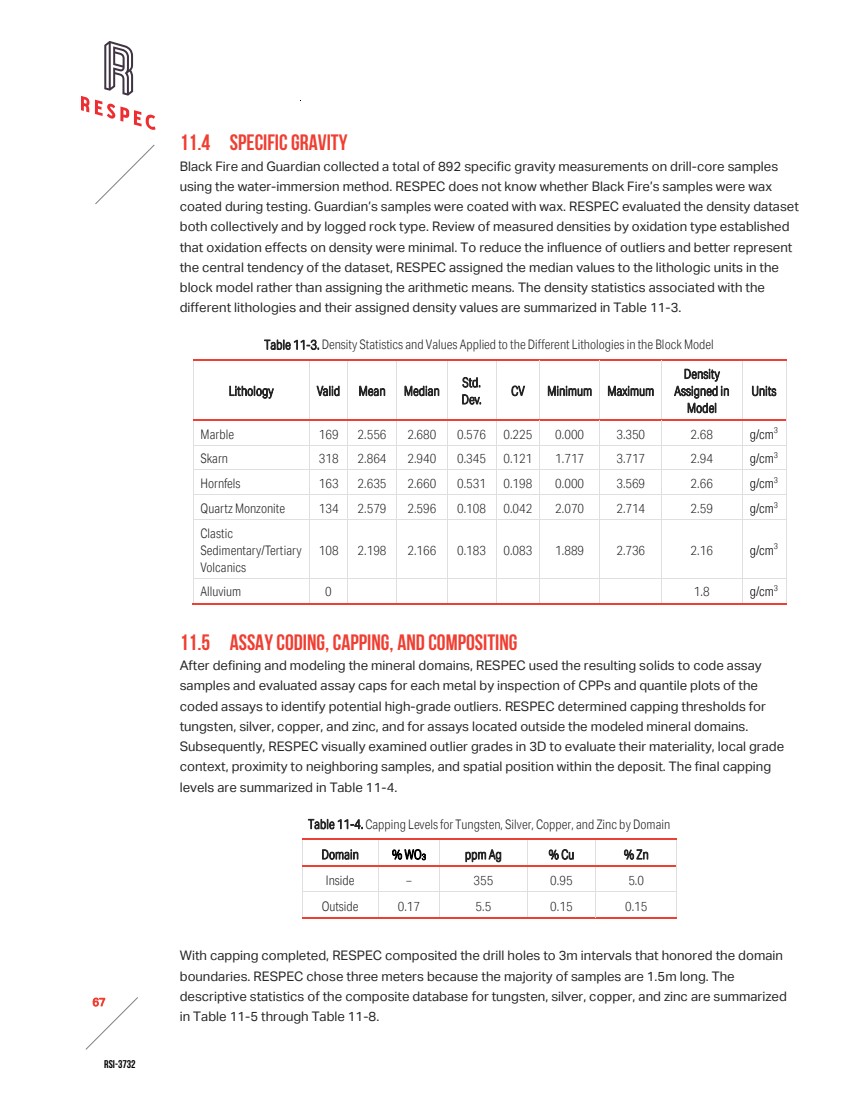
| RSI-3732 68 2 Table 11-5. Tungsten Composite Descriptive Statistics Inside Mineralized Domain Field Valid Minimum Maximum Mean Median Std. Devn. Co. of Variation Unit Length 2,052 0.4 4.45 3.004 3.00 0.249 0.083 m WO3 2,021 0.001 2.64 0.207 0.145 0.227 1.097 % WO3_Cap 2,021 0.001 2.64 0.207 0.145 0.227 1.097 % LITHC 2,044 2 7 Outside Mineralized Domain Field Valid Minimum Maximum Mean Median Std. Devn. Co. of Variation Unit Length 5,566 0.6 4.41 2.993 3.00 0.206 0.069 m WO3 2,155 0 0.694 0.014 0.003 0.047 3.36 % WO3_Cap 2,155 0 0.17 0.011 0.003 0.024 2.141 % LITHC 5,555 1 7 Table 11-6. Silver Composite Descriptive Statistics Inside Mineralized Domain Field Valid Minimum Maximum Mean Median Std. Devn. Co. of Variation Unit Length 2,074 0.4 4.45 2.972 3.00 0.424 0.143 m Ag 1,831 0.25 763.473 14.286 3.567 41.262 2.888 ppm Ag_Cap 1,831 0.25 355 13.483 3.567 33.863 2.512 ppm LITHC 2,065 2 7 Outside Mineralized Domain Field Valid Minimum Maximum Mean Median Std. Devn. Co. of Variation Unit Length 5,566 0.6 4.41 2.993 3.00 0.206 0.069 m Ag 2,065 0.034 100.155 1.443 0.5 4.918 3.408 ppm Ag_Cap 2,065 0.034 5.5 0.986 0.5 1.092 1.107 ppm LITHC 5,555 1 7 |
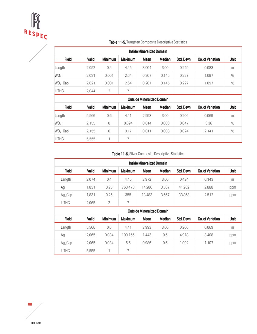
| RSI-3732 69 2 Table 11-7. Copper Composite Descriptive Statistics Inside Mineralized Domain Field Valid Minimum Maximum Mean Median Std. Devn. Co. of Variation Unit Length 2,052 0.4 4.45 3.004 3.00 0.249 0.083 m Cu 1,883 0 2.867 0.101 0.026 0.238 2.364 % Cu_Cap 1,883 0 0.95 0.087 0.026 0.164 1.877 % LITHC 2,044 2 7 Outside Mineralized Domain Field Valid Minimum Maximum Mean Median Std. Devn. Co. of Variation Unit Length 5,566 0.6 4.41 2.993 3.00 0.206 0.069 m % Cu 3,127 0 1.383 0.017 0.009 0.044 2.671 % Cu_Cap 3,127 0 0.15 0.015 0.009 0.019 1.314 % LITHC 5,555 1 7 Table 11-8. Zinc Composite Descriptive Statistics Inside Mineralized Domain Field Valid Minimum Maximum Mean Median Std. Devn. Co. of Variation Unit Length 2,052 0.4 4.45 3.004 3.00 0.249 0.083 m Zn 1,666 0.001 17.9 0.369 0.09 0.949 2.573 % Zn_Cap 1,666 0.001 5.0 0.34 0.09 0.679 1.999 % LITHC 2,052 2 7 Outside Mineralized Domain Field Valid Minimum Maximum Mean Median Std. Devn. Co. of Variation Unit Length 5,566 0.6 4.41 2.993 3.00 0.206 0.069 m Zn 2,052 0 4.9 0.022 0.007 0.125 5.619 % Zn_Cap 2,052 0 0.2 0.016 0.007 0.024 1.477 % LITHC 5,555 1 7 11.6 VARIOGRAPHY RESPEC conducted a variography study to evaluate grade continuity within the Desert Scheelite deposit. To assess spatial correlation and directional continuity of grades across the modeled domains, RESPEC generated traditional and pair‑wise variograms for tungsten, silver, copper, and zinc. The results informed the selection of estimation parameters for search ranges and anisotropy, ensuring that the resource model appropriately reflects the grade continuity and geological controls on mineralization. Table 11-9 summarizes the variography study by metal domain. |
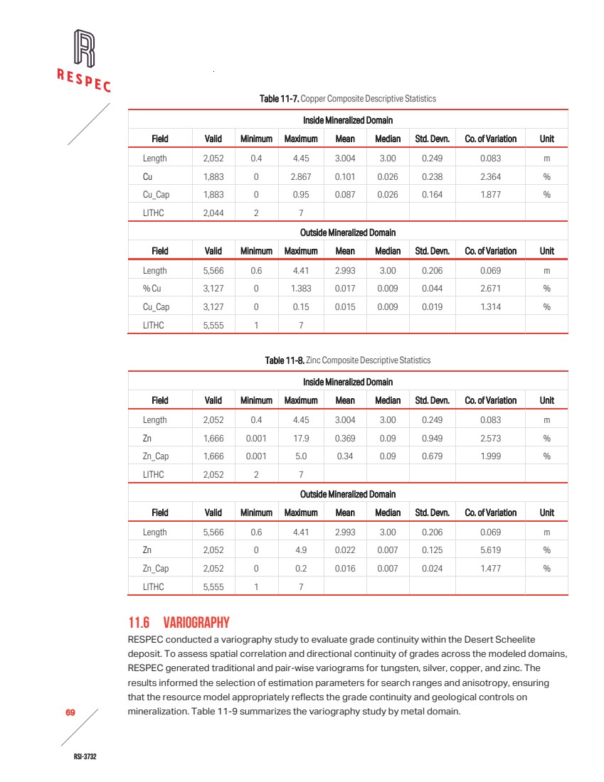
| RSI-3732 70 2 Table 11-9. Variography by Metal Domain Domain Direction Nugget First Sill Range (m) Second Sill Range (m) WO3 major 0.3 0.52 38 0.18 100 semimajor 17 40 minor 18 25 Ag major 0.25 0.5 10 0.25 40 semimajor 6.5 20 minor 7.5 14 Cu major 0.3 0.35 21 0.35 45 semimajor 14.5 35 minor 7.5 17 Zn major 0.2 0.65 24.5 0.15 70 semimajor 11 40 minor 12 34 11.7 BLOCK MODEL CODING RESPEC created a three-dimensional block model comprised of 5m x 2.5m x 5m blocks (model x, y, z). The block model is not rotated with a bearing of 0°. RESPEC chose the block size in consideration of the open pit mining scenario that would be the likely mining method for the Desert Scheelite deposit and used mineral domain solids to code partial volume percentages of the low-grade tungsten domains into blocks in the respective tungsten, silver, copper, and zinc models. The block models were also coded using the digital topographic surface and geology and oxidiation solids. RESPEC assigned the bulk density values to each block in the model based on lithology codes given in Table 11-3. (The bulk density values are discussed in Section 11.4.) The Desert Scheelite deposit is controlled sub‑vertically by lithologic contacts. The orientation of mineralization conforms to the irregular contact of the quartz monzonite intrusion. To properly represent this changing orientation, RESPEC applied MinePlan’s Dynamic Unfolding tool, which transforms sample coordinates into an unfolded reference frame aligned with the local geological controls. Once variograms and estimation parameters are established in the unfolded space, the results are transformed back into the original geometry to ensure that the resource model appropriately reflects the sub‑vertical controls and the curvilinear orientation of mineralization around the intrusion. As a result, a single search ellipse orientation was applied to each metal in the estimation, with local anisotropy accounted for through the unfolding process. The search ellipse orientations are summarized in Table 11-10. |
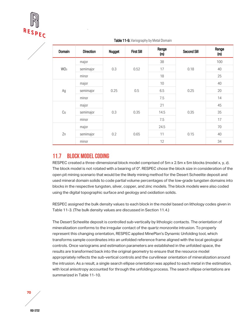
| RSI-3732 71 2 Table 11-10. Search Ellipse Orientations Domain Azimuth Dip Plunge WO3 256 -70 10 Ag 256 -77 10 Cu 256 -70 10 Zn 256 -80 10 11.8 GRADE INTERPOLATION RESPEC completed three estimation methods—ordinary kriging (“OK”), inverse distance squared (“ID2 ”), and nearest neighbor (“NN”)—and selected the kriged estimate as the reported mineral resource estimate. RESPEC used the ID2 and NN estimates as a check on the kriged interpolation. RESPEC performed estimation runs for each metal independently, using only the composites coded to a given low-grade domain or outside modeled domains to estimate grades into respective blocks. For each metal, RESPEC ran two successive passes: an initial long pass projecting 260m along the primary axes to populate all blocks, followed by a shorter pass. To limit excessive projection of unmodeled higher-grade mineralization, as determined on CPPs for each domain, RESPEC applied strong search range restrictions to the higher‑grade samples. These range restrictions were applied in the long pass for WO₃ and in all passes for silver, copper, and zinc. Strong anisotropic weighting was also applied to confine the estimation of various grade populations within the low-grade domains to narrow zones. The estimation parameters applied to tungsten, silver, copper, and zinc are summarized in Table 11-11. |
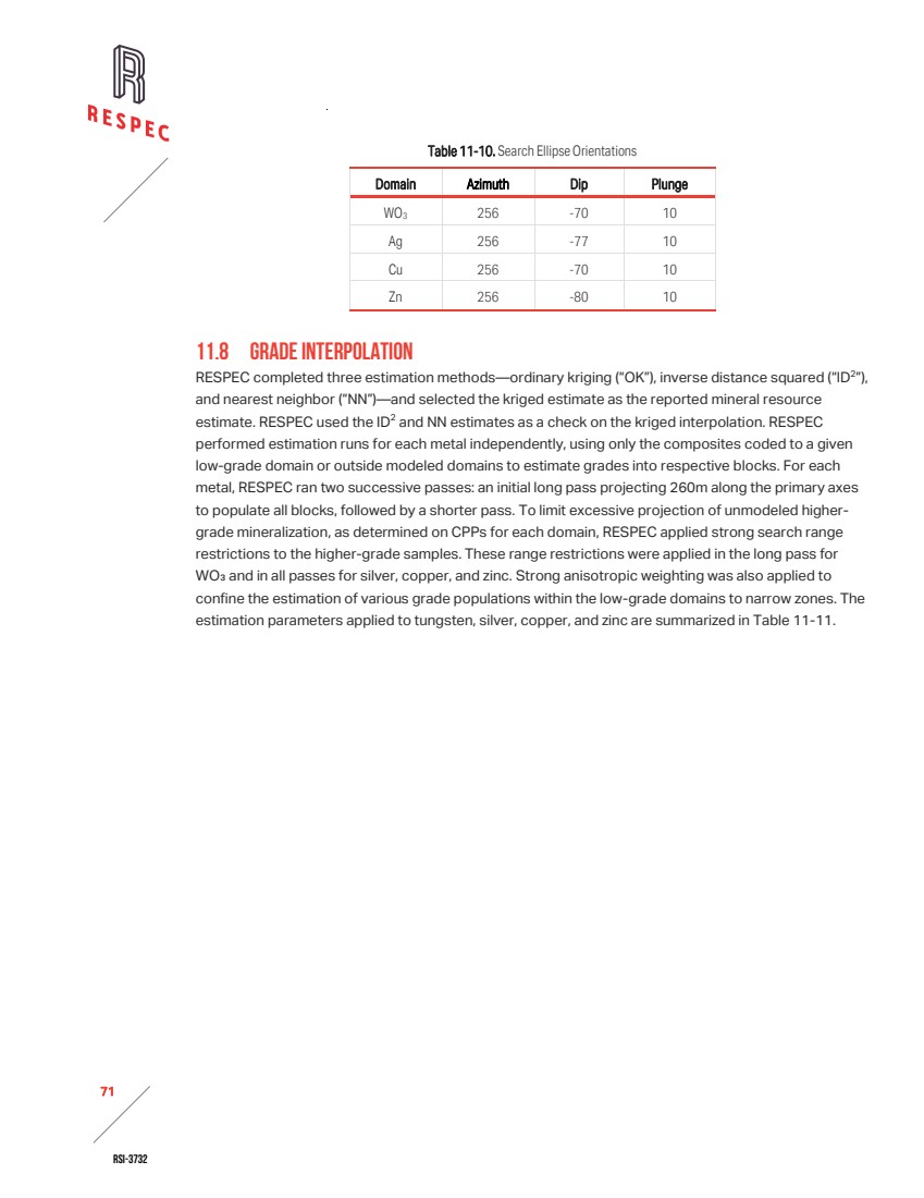
| RSI-3732 72 2 Table 11-11. Desert Scheelite Estimation Parameters (Page 1 of 2) Desert Scheelite Description Parameter Long Pass Short Pass WO3 Domain Samples: minimum | maximum | maximum per hole 1 | 9 | 3 1 | 9 | 3 Search anisotropies (m): major | semimajor | minor (vertical) 1 | 0.3 | 0.1 1 | 0.4 | 0.2 Maximum search distance (m) 260 100 High-grade restrictions (grade in % WO3, distance in m) 0.5 | 100 - Outside WO3 Domain Samples: minimum | maximum | maximum per hole 1 | 9 | 3 - Search anisotropies (m): major | semimajor | minor (vertical) 1 | 1 | 0.4 - Maximum search distance (m) 65 - High-grade restrictions (grade in % WO3, distance in m) 0.02 | 10 - Ag Domain Samples: minimum | maximum | maximum per hole 1 | 9 | 3 1 | 9 | 3 Search anisotropies (m): major | semimajor | minor (vertical) 1 | 0.3 | 0.07 1 | 0.5 | 0.5 Maximum search distance (m) 260 40 High-grade restrictions (grade in ppm Ag, distance in m) 15 | 40 15 | 40 Outside Ag Domain Samples: minimum | maximum | maximum per hole 1 | 9 | 3 - Search anisotropies (m): major | semimajor | minor (vertical) 1 | 1 | 0.4 - Maximum search distance (m) 65 - High-grade restrictions (grade in ppm Ag, distance in m) 5.5 | 10 - Cu Domain Samples: minimum/maximum/maximum per hole 1 | 9 | 3 1 | 9 | 3 Search anisotropies (m): major/semimajor/minor (vertical) 1 | 0.3 | 0.07 1 | 0.8 | 0.4 Maximum search distance (m) 260 45 High-grade restrictions (grade in % Cu, distance in m) 0.15 | 45 0.15 | 45 Outside Cu Domain Samples: minimum/maximum/maximum per hole 1 | 9 | 3 - Search anisotropies (m): major/semimajor/minor (vertical) 1 | 1 | 0.4 - Maximum search distance (m) 65 - High-grade restrictions (grade in % Cu, distance in m) 0.1 | 10 - |
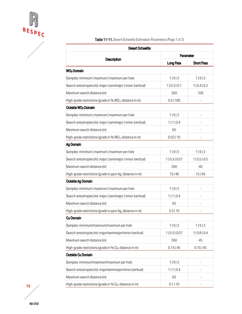
| RSI-3732 73 2 Table 11-11. Desert Scheelite Estimation Parameters (Page 2 of 2) Desert Scheelite Description Parameter Long Pass Short Pass Zn Domain Samples: minimum/maximum/maximum per hole 1 | 9 | 3 1 | 9 | 3 Search anisotropies (m): major/semimajor/minor (vertical) 1 | 0.3 | 0.14 1 | 0.5 | 0.4 Maximum search distance (m) 260 80 High-grade restrictions (grade in % Zn, distance in m) 0.5 | 80 0.5 | 80 Outside Zn Domain Samples: minimum/maximum/maximum per hole 1 | 9 | 3 - Search anisotropies (m): major/semimajor/minor (vertical) 1 | 1 | 0.4 - Maximum search distance (m) 65 - High-grade restrictions (grade in % Zn, distance in m) 0.1 | 10 - 11.9 CLASSIFICATION RESPEC has classified the Desert Scheelite mineral resources as indicated and inferred based primarily on drilling density and proximity to Guardian’s drilling. Other factors, such as the verification status of the drill-hole database and geologic understanding of the deposit and mineralization were considered. To incorporate these parameters, RESPEC constructed a solid around areas of denser drilling in which the majority of Guardian’s drilling is located. Regions with lower drill density, and those more reliant on historical data, were classified as inferred. This approach ensures that the reported resource reflects the greater confidence in the Guardian drill-hole dataset and the lesser confidence in areas predominantly defined by historical sampling. Uncertainties in the resource estimate primarily relate to the quality and reliability of historical data. These include the analytical methodologies employed by historical operators, which may not meet current industry standards, and the selective sampling evident in certain historical drill holes, which introduces potential bias in grade representation. The adequacy of drill-hole spacing, particularly along the down‑dip extent of the deposit where data density is lower, is considered in resource classification. While the modern drilling completed by Guardian provides a verified dataset that supports indicated classification in areas of higher density drilling, regions more reliant on historical information have been classified as inferred to reflect reduced confidence. Although the historical data cannot be fully verified, RESPEC made efforts to assess its reliability and alignment with Guardian’s drilling. RESPEC reviewed grade population statistics and completed a comparative test interpolation using historical‑only data versus Guardian‑only data. As discussed in Section 9.2.3.2, the analysis indicated that the historical-only dataset returned WO₃ grades approximately 17% higher than the Guardian-only dataset, possibly due to excessive estimated volume of higher grades resulting from the predominance of vertical drilling of steeply-dipping mineralization. |
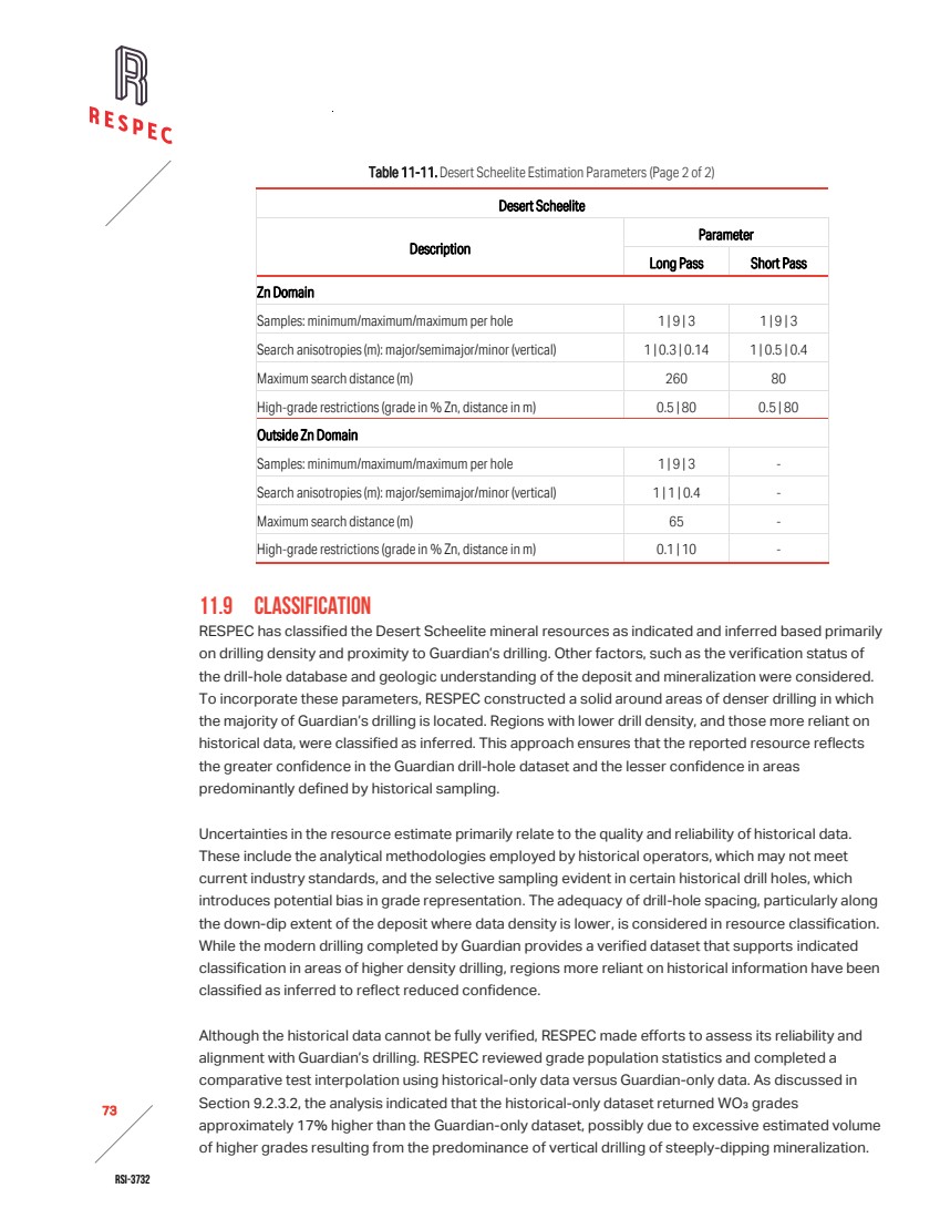
| RSI-3732 74 2 Although the difference is relatively high, the comparison demonstrated that the historical dataset is broadly consistent with Guardian’s results, supporting use of the historical data. To reflect the reduced confidence associated with historical analytical methodologies, selective sampling, and the possible excessive volume of higher estimated grades, RESPEC has classified resources informed primarily by historical holes (i.e. outside the indicated solid that delineates the bulk of Guardian drilling) as inferred. RESPEC acknowledges there is some risk associated with potential overstated volume of estimated higher-grade material proximal to historical drill holes within the indicated classification solid. 11.10 MINERAL RESOURCES RESPEC estimated the Desert Scheelite mineral resources to reflect potential open-pit extraction and processing by standard milling techniques. To meet the requirement of the resources having reasonable prospects for eventual economic extraction, a series of pits were optimized assuming open pit mining and processing costs typical for mining in Nevada (Table 11-12). RESPEC and Guardian relied on the five-year average ammonium para-tungstate price forecast published by Argus. In selecting the price assumption used for pit optimization, Guardian applied a discount to that independent forecast. Guardian determined that the five-year forward forecast was more representative of current and expected market conditions than historical pricing and applied the discount to reflect market volatility and the uncertainty inherent in forward-looking price projections. The resulting price assumption represents approximately 50% of the February 2026 spot price and was selected by Guardian to provide a conservative basis for the analysis. RESPEC reviewed and accepted the pricing forecast and payability for concentrate, which is based on the payability assessment included in the Argus forecast, for reliance. Table 11-12. Pit Optimization Parameters Item Value Unit Mining cost 2.75 $/tonne Mill processing cost 15.64 $/tonne processed Process rate 4,000 Tonnes-per-day processed General and Administrative cost 3.00 $/tonne processed WO3 price $65,500 $/tonne Ag price $1.22 $/gram Zn price $2,700 $/tonne WO3 recovery 80 Percent Ag recovery 60 Percent Cu recovery 70 Percent Zn recovery 60 Percent WO3 payability 83 Percent Ag payability 75 Percent Cu payability 0 Percent Zn payability 0 Percent |
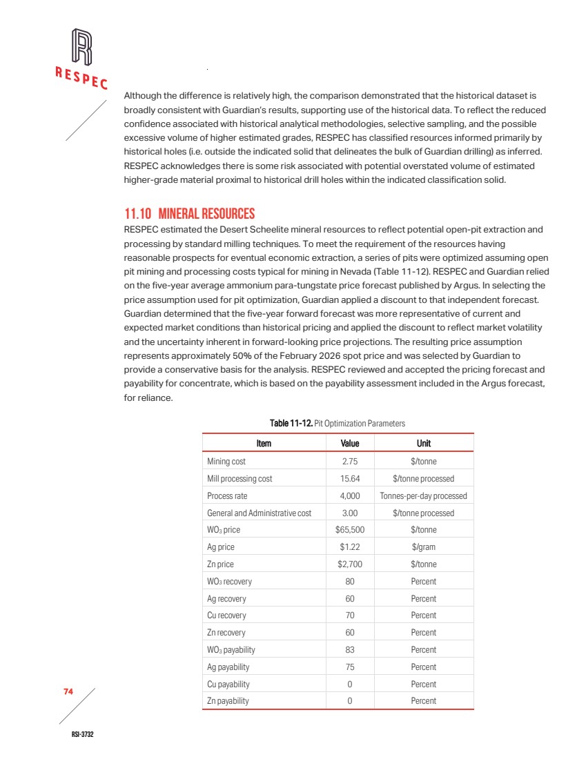
| RSI-3732 75 2 Table 11-13 presents the estimates of indicated and inferred mineral resources for the Desert Scheelite deposit. Of the total resources, 86% by contained tonnes WO₃ and 83% by total tonnes mined and processed are classified as indicated. Inferred resources may be upgraded to the indicated category with improved geological understanding and confirmation of the low-grade WO₃ domain model supported by additional drilling and assaying, and refinement of domains for all metals. These mineral resources are not mineral reserves and do not have demonstrated economic viability. The estimates are reported on diluted blocks measuring 5m by 2.5m by 5m. A representative cross section of the tungsten block model is shown in Figure 11-2. Table 11-13. Desert Scheelite Mineral Resources Cut-off Average Grade Contained Metal Classification % WO3 Tonnes % WO3 g Ag/t % Cu % Zn t WO3 oz Ag t Cu t Zn Indicated 0.06 8,694,000 0.206 12.43 0.085 0.315 17,900 3,475,000 7,400 27,400 Inferred 0.06 1,784,000 0.169 12.00 0.063 0.225 3,000 689,000 1,100 4,000 Notes: 1. The effective date of Desert Scheelite mineral resources is December 1, 2025. 2. The estimate of mineral resources was done by RESPEC in metric tonnes. 3. The point of reference is in situ mineralization prior to extraction by open pit mining methods. 4. The average grades of the tabulations are comprised of the weighted average of block-diluted grades within an optimized pit. 5. The Desert Scheelite mineral resource cut‑off grade of 0.06% WO₃ was selected by the authors. Operating assumptions were applied to establish a theoretical pit limit, including a WO₃ price of $65,500/t, an average recovery of 80% WO₃, a processing rate of 4,000 tonnes/day, $2.75/t mining cost for open pit, $15.64/t processing cost, $3.00/t processed for G&A, and an 83% payability. Blocks outside the pit limit are considered not economic at this time. 6. The accessory metals Ag, Cu, and Zn shown in Table 11-13 are the quantities contained within the mineral resources usinsg the cut-off grade established for the primary commodity(WO3). No independent cut-off grade has been applied to these accessory metals. Reported quantities of accessory metals are therefore considered by-products of the primary metal resource and their value is contingent upon the ability to economically extract the by-products along with the primary commodity. 7. The estimate of mineral resources may be materially affected by geology, environmental, permitting, legal, title, taxation, sociopolitical, marketing, or other relevant issues. 8. Rounding as required by reporting guidelines may result in apparent discrepancies between tonnes, grade, and contained metal content. 9. Mineral resources are not mineral reserves and do not have demonstrated economic viability. An inferred mineral resource has a lower level of confidence than an indicated mineral resource and must not be converted to a mineral reserve. RESPEC reasonably expectsthat continued exploration and delineation will upgrade the majority of inferred mineral resources to indicated mineral resources. |
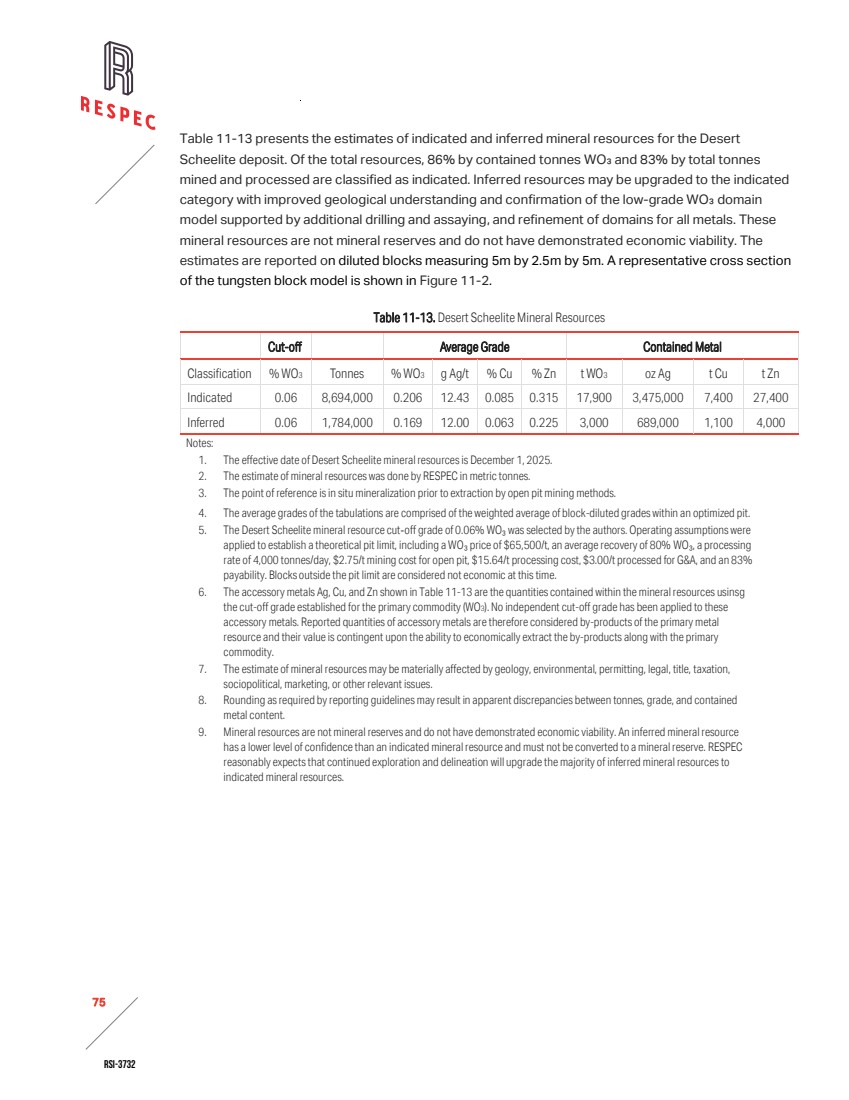
| RSI-3732 76 2 Figure 11-2. North-South Cross-Section 424305E Showing WO3 Grades in the Block Model. |
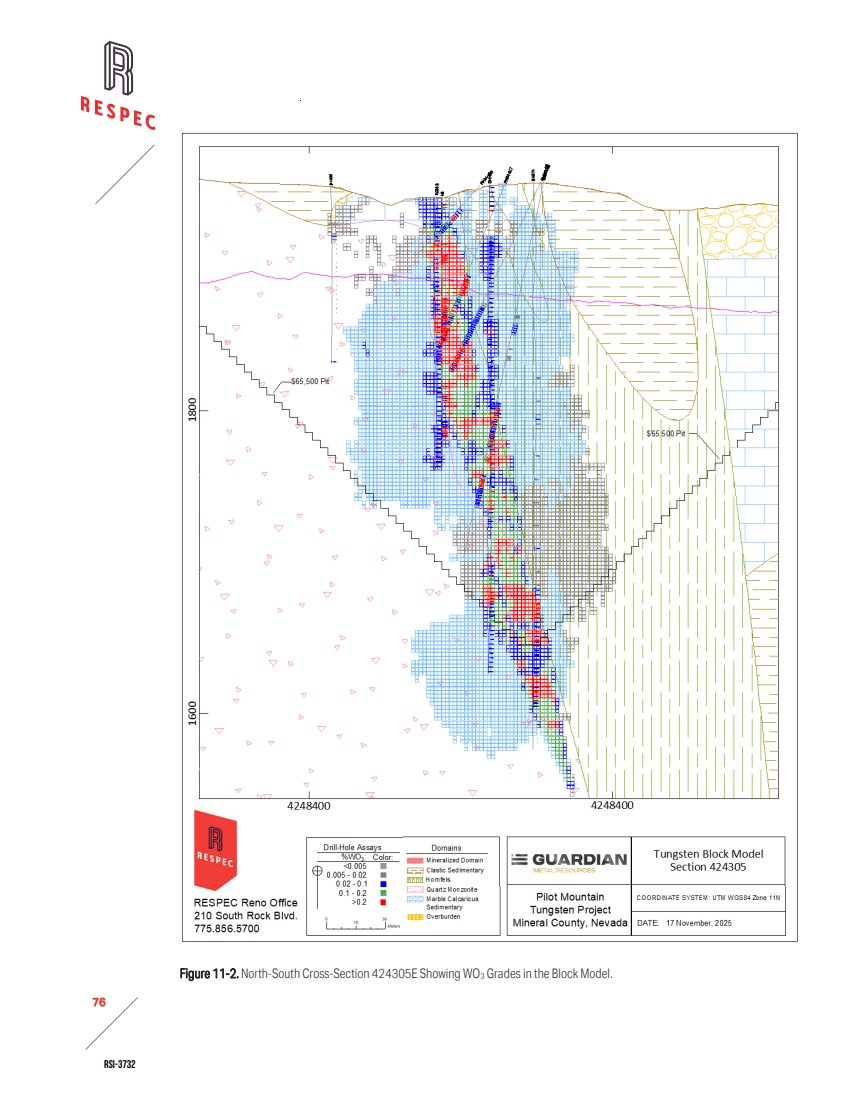
| RSI-3732 77 2 11.11 MODEL VALIDATION RESPEC systematically compared bench composite grades for WO₃, silver, copper, and zinc against coincident block estimated grades across the Desert Scheelite deposit. The results of this comparison are presented in Figure 11-3 for WO₃ only. The evaluation confirmed that block grades reproduce the distributional characteristics of the composited assay data at bench scale, with no evidence of material bias and revealed minor smoothing effects consistent with the applied interpolation methodologies. The smoothing of estimated block grades is within acceptable limits. The block model was also reviewed visually by comparing estimated block grades against the interpreted geology and the corresponding drill-hole assays, which confirmed that the block grades honor the geological framework and assay data at the deposit scale. This validation demonstrates that the models for all reported metals are reasonable and reliable, thereby meeting the requirements for disclosure under S‑K 1300 standards. . Figure 11-3. WO3 Bench Composite Grades versus Coincident Block Grades Interpolated by OK, ID2 , and NN. 11.12 DISCUSSION OF RESOURCES The Desert Scheelite mineral resources are associated with a base‑metal enriched tungsten skarn developed within lower Luning Formation carbonates and interbedded biotite hornfels. The skarn zone extends for approximately 600m along the contact of the Desert Scheelite quartz monzonite stock and persists for at least 300m down‑dip. Mineralization is characterized by abundant scheelite accompanied by pyrite and base-metal sulfides, principally chalcopyrite and sphalerite. Mineralization is |
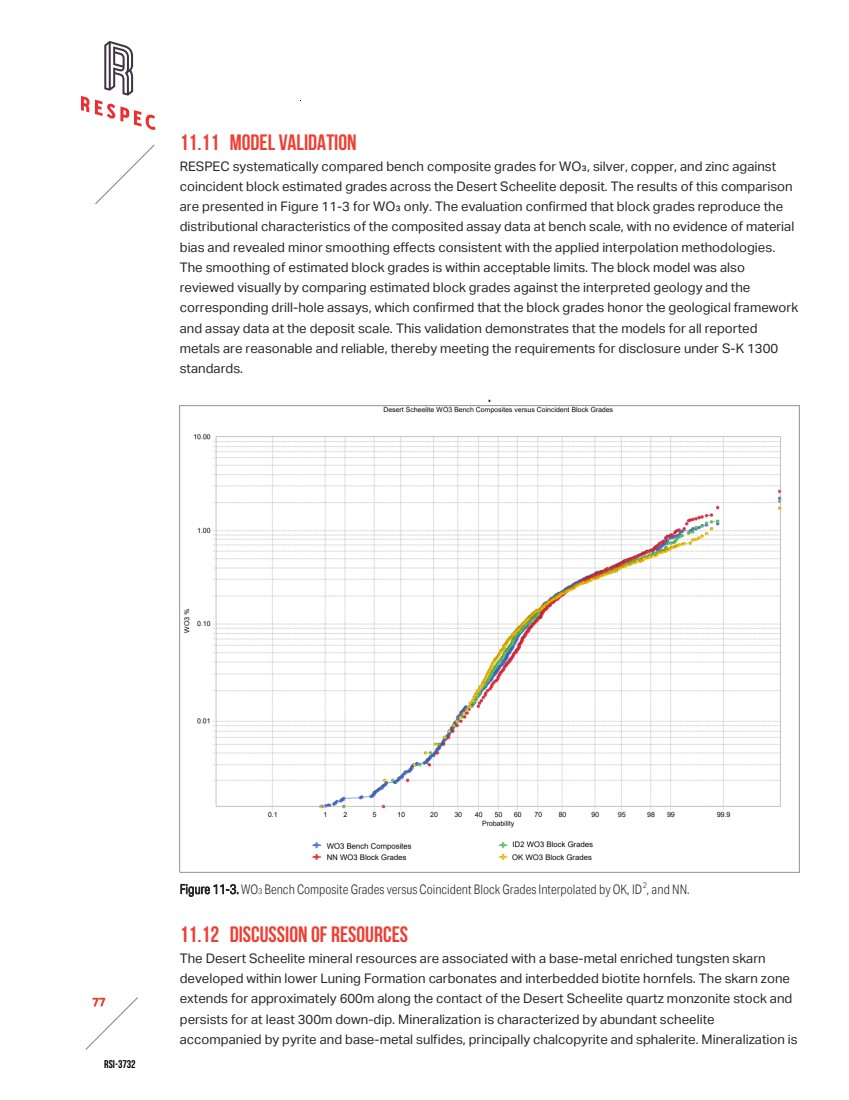
| RSI-3732 78 2 oriented sub-vertically and includes three higher-grade tungsten zones within skarn or marble hosts, which may reflect favorable structural and lithological controls. A significant outcome of Guardian’s work has been an improved understanding of the orientation and continuity of mineralization, leading to the development of a new geologic model. RESPEC’s tungsten domain modeling and resource estimation were based on this geologic model, which also provides a framework to guide future drilling at the Desert Scheelite deposit. The Desert Scheelite mineral resources have been estimated assuming potential open-pit extraction and processing by standard milling and flotation techniques. RESPEC optimized a series of pits at variable WO₃ prices using fixed mining and processing costs reflective of Nevada operations to evaluate near-surface mineralization that, under assumed and justifiable technical and economic conditions, is likely to be, in whole or in part, economically extractable. The mineral resources are reported at a cut-off grade of 0.06% WO3 within the optimized pit. Silver, copper, and zinc quantities within the mineral resources established using the WO3 cut-off grade are also reported, but their value is dependent on the ability to economically extract the by-products. No independent cut-off grades were applied to silver, copper, or zinc, and these metals were not incorporated into a tungsten-equivalent grade. Those metals are considered by-products contingent upon economic extraction of WO3. A majority (83%) of the Desert Scheelite mineral resources have been classified as indicated, reflecting the drilling density achieved by Guardian, the supporting QA/QC data, and the improved geological understanding of the deposit. More than 97% of the indicated blocks incorporate the maximum number of composites used in grade estimation. Offsetting these positive attributes, uncertainties in the resource estimate relate primarily to the quality and reliability of historical data. These include analytical methodologies employed by historical operators that may not align with current industry standards and selective sampling in certain historical drill holes that could introduce bias in grade representation. Drill‑hole spacing, particularly along the down‑dip extent of the deposit where data density is lower, results in those areas remaining classified as inferred. Other limitations in the historical dataset include incomplete down‑hole survey records and inconsistent assay documentation. RESPEC audits confirmed that the Guardian, Duval, and UCC datasets exhibit broadly consistent and comparable grade distributions, supporting comparability of grade populations despite differences in dataset size, detection limits, and selective sampling. Interpolation tests indicated that historical datasets returned WO₃ grades approximately 17% higher than Guardian’s, a difference attributed to sampling population effects and drilling geometry rather than systematic analytical bias. Confidence in pre‑Guardian data is therefore lower, and the apparent thickness of higher‑grade intervals may be exaggerated in areas influenced predominantly by historical data. Guardian’s angled drilling in 2024- 2025 reduced this geometric bias and provides a reliable foundation for the resource model. RESPEC acknowledges that some risk remains, which may be mitigated through additional infill drilling, twin‑hole grade comparisons, and petrological studies to better define the spatial association of high‑grade zones. |
| RSI-3732 79 2 Multiple grade populations were observed on the CPP of each metal. Although second, higher-grade populations were apparent on the charts and in drill assays during modeling, the geological characteristics of the higher grades were not understood and were therefore not used in the model. The higher-grade assay population was controlled by applying strong search restrictions to the estimate, however, there is a risk that some of the grade is smeared within the low-grade domain. The model is considered to provide a reasonable representation of the overall quantity of contained metal. Local variations in grade distribution, however, may be less reliably captured and remain subject to uncertainty. |

| RSI-3732 80 2 12.0 MINERAL RESERVE ESTIMATES No Mineral Reserves are reported in this technical report. |
| RSI-3732 81 2 13.0 MINING METHODS For the purposes of determining a reasonable probability of economic extraction for the resources and open pit mining method was assumed and preliminary pits were assessed. |
| RSI-3732 82 2 14.0PROCESSING AND RECOVERY METHODS For the purposes of determining a reasonable probability of economic extraction for the resources a grinding and mineral floatation recovery method was assumed. |
| RSI-3732 83 2 15.0INFRASTRUCTURE The property connects to grid power, but the timing of electrical delivery from NV Energy remains uncertain. The project may need to evaluate and cost on‑site power generation to support the initial years of operations. Guardian must secure water rights for volumes to be defined in the pre‑feasibility study. Guardian has sourced sufficient water for drilling and engineering test work from an existing historical borehole on site. Road access requires improvements to support potential construction activities. |

| RSI-3732 84 2 16.0 MARKET STUDIES No market studies and contracts are reported in this technical report. |

| RSI-3732 85 2 17.0ENVIRONMENTAL STUDIES, PERMITTING, AND PLANS, NEGOTIATIONS, OR AGREEMENTS WITH LOCAL INDIVIDUALS OR GROUPS This summary is based on information provided by Guardian, including their compilation of baseline studies completed by WestLand Engineering & Environmental Services (“WestLand”) and Guardian’s own work. RESPEC has prepared this summary for reporting purposes but has not independently verified the underlying data or conclusions. The WestLand surveys referenced herein are listed in Section 24.0. 17.1 EXPLORATION PERMITTING REQUIREMENTS Exploration activities on public and private lands in Nevada fall under the jurisdiction of the NDEP Bureau of Mining Regulation and Reclamation (“BMRR”), and either the BLM or the U.S. Forest Service (“USFS”) for public lands. For exploration projects disturbing less than five acres on public land, the BLM or USFS requires a NOI and a reclamation bond. Projects proposing more than five acres of disturbance must submit a PoO and EA to the land management agency, along with a reclamation permit application to NDEP–BMRR. Nevada Revised Statutes (NRS 519A.010–519A.290) and Nevada Administrative Code (NAC 519A.120– 519A.345) establish the regulatory authority for reclamation permitting. Additional provisions governing surety, fluid management trust funds, and enforcement appear in NRS 519A.350–519A.392. 17.2 PERMITTING STATUS Guardian submitted a revised PoO on June 3, 2025, addressing comments from both the BLM and NDEP. Guardian also submitted a revised Reclamation Plan to NDEP–BMRR. Guardian has completed the following permitting steps: / Guardian completed baseline environmental studies, and the BLM accepted them. / Guardian submitted the Exploration PoO and the NDEP Reclamation Permit Application to both agencies, and they accepted the submission as complete. The permit will be issued following NEPA approval of the PoO. / Guardian submitted a draft EA to the BLM on November 19, 2025. The draft included completed forms requesting authorization for exploration drilling under the expedited procedures outlined in the Department of Interior’s Alternative Arrangements for Compliance with the National Environmental Policy Act Amid the National Energy Emergency (April 23, 2025) for critical minerals. 17.3 BIOLOGICAL RESOURCES AND HABITAT SURVEYS WestLand conducted biological baseline studies in 2024 and 2025 across the project area and required buffer zones. In the 2024 Baseline Biological Survey Report, WestLand documented vegetation and |
| RSI-3732 86 2 wildlife habitat mapping, noxious weed and invasive species surveys, BLM Special Status Species surveys, greater sage-grouse and burrowing owl presence/absence surveys, migratory bird and raptor surveys, acoustic bat surveys, and golden eagle habitat analysis and surveys. WestLand completed 16 field surveys during the 2024–2025 baseline period. The surveys did not identify leks or golden eagle nests within the project boundary, although they observed four golden eagle nests within the two‑mile buffer zone. Guardian commissioned WestLand to produce two addendums to the 2024 biological report: the 2025 Cold Season Internal Bat Survey Addendum and the 2025 Burrowing Owl Survey Addendum. Guardian also commissioned WestLand to complete the 2025 Golden Eagle Occupancy and Reproduction Assessment to supplement baseline data. 17.4 CONCLUSIONS RESPEC offers no conclusions regarding the content in this section and presents the summary of work completed for informational purposes only. The conclusions below are paraphrased from Guardian. The USFS reviewed the survey area using Endangered Species Act (“ESA”) mapping tools and identified no critical habitats or migratory birds of concern within the intersecting USGS 7.5‑minute quadrangles. On‑site biological surveys conducted by WestLand confirmed the absence of federally listed threatened or endangered species within the project area. |
| RSI-3732 87 2 18.0CAPITAL AND OPERATING COSTS No capital or operating costs are reported in this technical report. |

| RSI-3732 88 2 19.0ECONOMIC ANALYSIS No economic analysis is reported in this technical report. |

| RSI-3732 89 2 20.0 ADJACENT PROPERTIES There are no operating mines or near-production properties within 20 miles of the Pilot Mountain Project. There are active exploration properties near Tonopah and Hawthorne. |
| RSI-3732 90 2 21.0OTHER RELEVANT DATA AND INFORMATION There are no other relevant disclosures. |

| RSI-3732 91 2 22.0INTERPRETATION AND CONCLUSIONS 22.1 ADEQUACY OF THE DATA USED IN ESTIMATING THE PROJECT MINERAL RESOURCES RESPEC’s audit confirmed that overall, the available data are adequate for mineral resource estimation and disclosure under S-K 1300. Historical records have inconsistencies in assay documentation or missing down-hole survey documentation, which were addressed through comparative analysis. Confidence in pre-Guardian drilling remains lower, but Guardian’s 2024–2025 drilling program provides a reliable foundation for the resource model. RESPEC integrated the historical information with appropriate caution, and while some risk persists in the estimated volume of higher-grade material, the database is considered suitable for technical reporting, resource estimation, and regulatory compliance. Guardian conducted their 2024–2025 drilling programs to current industry standards. RESPEC judged Guardian’s core handling, sampling, and chain‑of‑custody procedures adequate to produce reliable samples for assay. ALS performed sample preparation and analysis using appropriate multi‑element and ore‑grade methods, and re‑assayed overlimit values. Guardian’s QA/QC program incorporated certified reference materials, blanks, and duplicates at appropriate frequencies. Statistical evaluation confirmed acceptable precision and minimal bias for tungsten, copper, and zinc. Evaluation of the silver assays showed slightly elevated variability at low concentrations but revealed no systematic errors. Overall, Guardian’s QA/QC results are adequate for resource estimation, although their follow‑up on isolated CRM and blank failures is not documented. Data collected by Black Fire and Thor between 2011 and 2017 were prepared and analyzed by ISO‑accredited laboratories, with documented procedures providing some confidence in quality. Drilling completed in the 1970s lacks documented sampling protocols and QA/QC records, which reduces confidence in those datasets. Even so, select historical assay results were incorporated into the resource estimate where comparative analysis against modern data supported their reliability. Assay population reviews show broadly consistent grade distributions across Guardian, Duval, and UCC datasets, which supports their comparability despite differences in dataset size and detection limits. Interpolation tests indicated that historical datasets returned WO₃ grades about 17% higher than Guardian’s, a difference attributed to sampling population effects and drilling geometry rather than systematic analytical bias. These findings reinforce the conjecture that estimation risk is primarily linked to the historical dataset, particularly in areas where vertical drilling and selective sampling may have biased grade representation. Guardian’s angled drilling reduced geometric bias, and the modern dataset provides confidence in the overall resource model. Assays generated by colorimetric methods during the 1970s campaigns are accepted for inclusion in the resource model. Although less precise than modern instrumental techniques, colorimetry was a recognized practice for tungsten analysis at the time. Partial assay certificates recovered by Guardian provides traceability. Despite the absence of QA/QC data from the original campaigns, corroborating evidence from comparative analyses supports the selective use of historical colorimetric results in the current estimate. |
| RSI-3732 92 2 22.2 EXPLORATION Drilling at the Pilot Mountain Tungsten Project has been conducted intermittently since 1968, with successive operators contributing to the understanding of mineralization at Desert Scheelite, Good Hope, Gunmetal, and Garnet. Early programs by Hecla and Duval tested porphyry copper‑molybdenum targets and tactite zones, with Duval later identifying copper‑tungsten mineralization northeast of Desert Scheelite. Grace’s angled drilling in 1975 confirmed the width of steeply dipping mineralization, which improved understanding of deposit geometry. UCC’s work in the late 1970s extended scheelite mineralization into the Middle Gunmetal/South Contact areas and supported their acquisition of the property. Black Fire’s 2011 campaign focused on verifying historical assays and Thor’s 2017 exploration tested for copper‑silver mineralization, providing continuity of exploration and supporting initial resource estimates. Guardian’s 2024–2025 program represents the most comprehensive modern dataset, with 89 diamond core holes (68 at Desert Scheelite, 20 at Garnet, and one in the quartz monzonite stock). Guardian’s drill-hole locations were professionally surveyed. Overall, the drilling record demonstrates progressive refinement of the understanding of deposit geometry and grade distribution. Historical campaigns established the presence of scheelite mineralization but were limited by vertical drilling and selective sampling. Guardian’s modern program reduced geometric bias, provided reliable assay data, and forms the backbone of the resource model. 22.3 GEOLOGY AND MINERALIZATION The Pilot Mountain Tungsten Project lies within the Walker Lane structural belt of western Nevada, a zone of strike-slip faulting, extensional basins, and magmatism that has strongly influenced mineralization patterns. The Triassic Luning Formation hosts the mineralization at Pilot Mountain and represents the primary stratigraphic unit of interest in the project area. The formation is subdivided into lower, middle, and upper members, and is intruded by Jurassic to Cretaceous granitic stocks and overlain by Tertiary volcanic units. Intrusion of Jurassic quartz monzonite stocks produced contact metamorphism and skarn alteration within adjacent carbonate rocks. The Desert Scheelite deposit is a tungsten skarn formed along the contact of the quartz monzonite stock within lower Luning carbonates and biotite hornfels. Scheelite is the dominant ore mineral, accompanied by pyrite, chalcopyrite, and sphalerite, with local base‑metal sulfide contents exceeding 20% in unoxidized samples. Skarn assemblages include pyroxene‑rich and garnet‑rich varieties, with the latter showing variable base‑metal enrichment linked to the geochemical character of individual intrusions. 22.4 MINERAL RESOURCES The Desert Scheelite mineral resources are defined within a base-metal enriched tungsten skarn and extend approximately 600m along strike and at least 300m down-dip. Mineralization is sub-vertical and includes three higher-grade tungsten zones which reflect structural and lithological controls. Guardian’s drilling and geologic modeling improved understanding of mineralization continuity and provided the basis for tungsten domain modeling and resource estimation. |
| RSI-3732 93 2 RESPEC estimated resources assuming potential open-pit extraction with standard milling and flotation techniques. RESPEC optimized pits at variable WO₃ prices using Nevada-based cost assumptions to evaluate near-surface mineralization that is likely to be, in whole or in part, economically extractable. Resources are reported at a 0.06% WO₃ cut-off grade. Silver, copper, and zinc are also reported, but their value is dependent on the ability to economically extract the by-products. A majority of resources (83%) are classified as indicated, supported by Guardian’s drilling density, QA/QC data, and improved geologic understanding. Uncertainties remain due to limitations in historical datasets, including incomplete survey records, inconsistent assay documentation, selective sampling, and the predominance of vertical holes in steeply dipping zones, which may have exaggerated estimated higher‑grade thicknesses. Guardian’s angled drilling reduced geometric bias, but some risk remains in the estimated volume of higher‑grade material. |

| RSI-3732 94 2 23.0 RECOMMENDATIONS RESPEC considers the Pilot Mountain Tungsten Project to be a project of merit and recommends the proposed program and level of expenditures outlined herein. 23.1 PHASE 1 RECOMMENDED ACTIVITIES AND BUDGET RESPEC recommends that the next phase of work at Desert Scheelite focus on reducing estimation risk, validating historical data, and advancing the deposit toward feasibility-level evaluation. Guardian has initiated a pre-feasibility study, for which early-stage work is underway. To support and de-risk the Desert Scheelite model and mineral resources through this process, RESPEC proposes an approximately $10.55 million phase 1 budget summarized in Table 23-1 to complete the following activities: Drilling and Assay Programs RESPEC recommends that Guardian complete 1,500m of core drilling at Desert Scheelite. The program should increase drill density, improve confidence in grade continuity, and support conversion of inferred blocks to indicated. In particular, RESPEC recommends infill drilling in both indicated and inferred areas within the optimized pit to test the quality of the current tungsten low-grade domain model and resource estimate. RESPEC further recommends incorporation of select twin holes to validate historical assays, particularly in areas where vertical drilling may have exaggerated grade thicknesses. RESPEC advises Guardian to maintain current insertion rates of CRMs, blanks, and duplicates, and to document follow-ups with the assay laboratories on QA/QC failures to increase the defensibility of the dataset. In addition to Desert Scheelite, RESPEC recommends advancing drilling at the Garnet and Gunmetal deposits, with approximately 1,800m of core drilling planned at each. These programs will test extensions of known mineralization, improve confidence in resource geometry, and provide data to support initial resource classification. Exploration drilling totaling 2,000m is also proposed to evaluate additional targets across the Pilot Mountain property, which may contribute to future resource expansion. Petrological, Ore Characterization, and Metallurgical Studies RESPEC recommends that Guardian undertake detailed mineralogical and ore characterization studies to refine understanding of scheelite and its alteration patterns, variability in high-grade zones, and base-metal associations. RESPEC further recommends integrating these studies with metallurgical test work to build on initial evaluations of WO₃ recovery, processing performance, flotation efficiency, and by-product recoveries. Studies linking geologic variability with processing outcomes are critical to the pre-feasibility study. Geologic and Metal Domain Modeling RESPEC recommends that Guardian update geologic modeling to refine lithologic and alteration contacts and incorporate structural features that may control higher-grade mineralization. RESPEC advises continued refinement of domain boundaries and improvement of block-model reliability. Any |
| RSI-3732 95 2 updates that materially change Desert Scheelite mineral resources should be documented and reported to maintain compliance with S-K 1300 requirements. In particular, RESPEC recommends that Guardian characterize the multiple grade populations observed on the CPPs of each metal. Although second, higher-grade populations were apparent on the charts and in drill assays during modeling, the geological characteristics of the higher grades were not understood, and were therefore not used in the model. As a result, the overall quantity of metal is likely well-represented by the model, but the local distribution of grade may not be. Understanding and modeling the higher-grade domains would reduce the local risks associated with mixing of different assay populations within the low-grade domain. Hydrology, Permitting, and Bonding RESPEC recommends that Guardian continue the hydrology study to establish baseline hydrogeological data, inform pit design, and evaluate dewatering requirements. RESPEC further recommends advancing permitting and bonding activities in parallel to ensure regulatory compliance and reduce risk in mine-planning assumptions. Support Infrastructure RESPEC recommends that Guardian secure labor, support staff, equipment, and materials at appropriate levels to sustain operational continuity and technical execution across drilling, analytical, and study programs. Adequate resourcing will enable successful delivery of work programs and maintain project progress. Table 23-1. Guardian Cost Estimate for Pilot Mountain Tungsten Project Recommended Work—Phase 1 Task Qty Unit US$ per unit US$ Desert Scheelite Core Drilling 1,500 meter $520 $780,000 Garnet Core Drilling 1,800 meter $520 $936,000 Gunmetal Core Drilling 1,800 meter $520 $936,000 Exploration Core Drilling 2,000 meter $520 $1,040,000 Assays 4,700 samples $55 $260,000 Metallurgical Test Work $450,000 Geological Modelling $25,000 Hydrology Study $675,000 Ore Characterization Study $525,000 Permitting and Bonding $645,000 Pre-Feasibility Study $1,620,000 Reporting $220,000 Labor / Support Staff $2,370,000 Equipment and Materials $70,000 Total $10,552,000 |
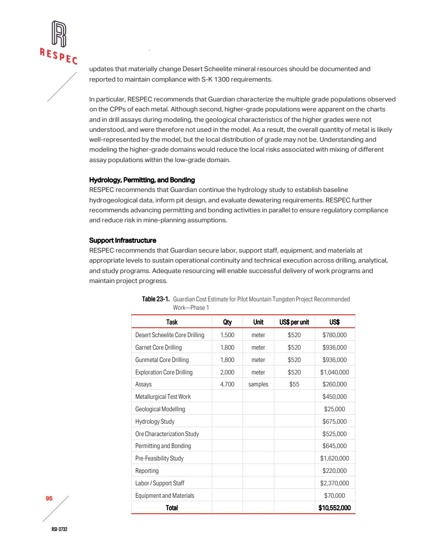
| RSI-3732 96 2 23.2 PHASE 2 RECOMMENDED ACTIVITIES AND BUDGET Following completion of phase 1 activities, RESPEC recommends advancing a second phase of work to support feasibility evaluation and reduce remaining technical and regulatory risks. Phase 2 is designed to expand the resource base, refine engineering inputs, and strengthen environmental and permitting foundations. The proposed phase 2 activities and budget of ~$8.48 million are summarized below and in Table 23-2. Core Drilling RESPEC recommends that Guardian complete additional core drilling across the Desert Scheelite, Garnet, and Gunmetal deposits and on exploration targets identified in phase 1 exploration. This program will test extensions of known mineralization, evaluate new zones identified during Phase 1, and improve confidence in resource geometry. RESPEC expects these results to support updated block models and contribute to the conversion of inferred material to indicated or measured categories. Metallurgical Test Work RESPEC recommends that Guardian conduct follow-up metallurgical studies. These tests will include variability assessments across multiple deposits and will refine recovery assumptions for tungsten and associated by-products. RESPEC advises that the results feed directly into process design and feasibility-level engineering. Permitting and Bonding RESPEC recommends that Guardian expand permitting and bonding activities. This work will address environmental data collection, bonding requirements, and regulatory submissions necessary to advance the project. Feasibility Study RESPEC recommends that Guardian complete a full feasibility study. This study will evaluate economic viability using updated technical and cost assumptions. RESPEC expects the feasibility study to incorporate revised resource models, metallurgical data, mine design, infrastructure planning, and permitting outcomes. Labor and Support Staff RESPEC recommends that Guardian continue to allocate resources to labor and support staff to manage drilling, data integration, engineering, and permitting workflows. Infrastructure RESPEC recommends that Guardian invest in infrastructure to support field operations, data collection, and logistics. This investment will include upgrades to access roads, core handling facilities, and temporary utilities required for sustained exploration and study activities. |
| RSI-3732 97 2 Table 23-2. Guardian Cost Estimate for Pilot Mountain Tungsten Project Recommended Work—Phase 2 Task Qty Unit US$ per unit US$ Core Drilling 6,500 meter $520 $3,380,000 Metallurgical Test Work $200,000 Permitting and Bonding $900,000 Feasibility Study $1,000,000 Labor / Support Staff $2,000,000 Infrastructure $1,000,000 Total $8,480,000 |
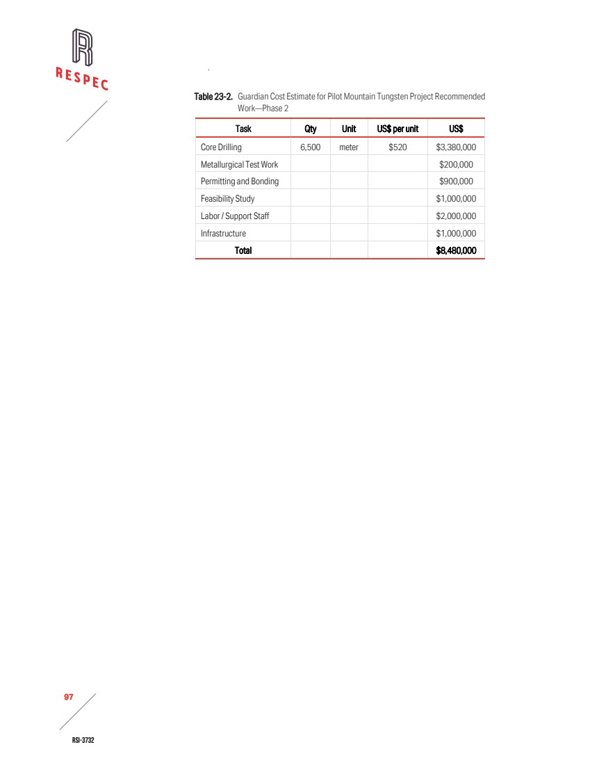
| RSI-3732 98 2 24.0 REFERENCES Several technical resource reports have been prepared for Pilot Mountain resources areas, none that were S-K 1300 compliant. They are as follows: Golder Associates, 2012. Desert Scheelite Resource, with Final Report Number 127641013-002-R-Rev0, prepared by Golder Associates Pty Ltd. Kaiser Engineers, 1981. Feasibility Study for Mining and Concentrating of Pilot Mountain Tungsten Ore, Mineral County, Nevada, prepared by Kaiser Engineers for Union Carbide Corporation Metals Division. RES, 2018. Update of Golder Associates Desert Scheelite Resource, prepared by Resource Evaluation Services (RES) for Thor Mining PLC. Vidale, Andrew, 2018. Pilot Mountain Mining Scoping Study, prepared by Andrew Vidale Consulting Services on behalf of for Thor Mining PLC. Other sources: American Eagle Research Institute, 2025. “Pilot Mountain Exploration Project: 2025 Golden Eagle Occupancy and Reproduction Assessment,” prepared for WestLand Engineering & Environmental Services. Faulds, J. E. and C. D. Henry, 2008. “Tectonic Influences on The Spatial And Temporal Evolution of The Walker Lane: An Incipient Transform Fault Along The Evolving Pacific – North American Plate Boundary,” in Spencer, J. E. and S. R. Titley, editors, Ores and Orogenesis: Circum-Pacific Tectonics, Geologic Evolution, and Ore Deposits, Arizona Geological Society Digest, Vol. 22, pp. 437-470. Grabher, D. E., 1984. “Union Carbide's Pilot Mountain Project Geologic Setting and Field Trip Guide,” in Exploration for Ore in the American Cordillera, J. L. Johnson, ed., Association of Exploration Geochemists, pp. 5-24. Lederer, G. W., F. Solano, J. A. Coyan, K. M. Denton, K. E. Watts, C. N. Mercer, D. P. Bickerstaff, and M. Granitto, 2021. “Tungsten Skarn Mineral Resource Assessment of the Great Basin Region of Western Nevada and Eastern California,” Journal of Geochemical Exploration , Vol. 223, pp. 1-24. Nielsen, R. L., 1963. Geology of the Pilot Mountains and Vicinity, Mineral County, Nevada, PH.D. thesis, University of California, Berkeley. Oldow, J. S., 1978. “Triassic Pamlico Formation: An Allochthonous Sequence of Volcanogenic-Carbonate Rocks in West Central Nevada,” in Mesozoic Paleogeography of the Western United |
| RSI-3732 99 2 States, edited by Howell, D. G., and K. A. McDougall, SEPM, Pacific Section, Pacific Coast Paleogeography Symposium 2, pp. 223-235. Samuel Engineering. 2025. “Metallurgical Test Work: Pilot Mountain PFS,” [Project memorandum]. Samuel Engineering, Greenwood Village, CO. Speed, R. C. 1977. “Island arc and other paleogeographic terranes of Late Paleozoic age in the western Great Basin,” in Paleozoic Paleogeography of the Western United States, edited by Stewart, J.S., Stevens, C.H., and Fritsche, A. E., SEPM, Pacific Coast Section, Pacific Coast Paleogeography Symposium 1, pp. 349-362. Western Regional Climate Center, 2013. Cooperative Climatological Data Summaries. Retrieved from http://wrcc.dri.edu/climatedata/climsum/ WestLand Engineering & Environmental Services, 2024. “Pilot Mountain Exploration Project: 2024 Pre-Field Habitat Assessment.” WestLand Engineering & Environmental Services, 2025a. “Pilot Mountain Exploration Project: 2024 Baseline Biological Survey Report.” WestLand Engineering & Environmental Services, 2025b. “2025 Cold Season Internal Bat Survey,” addendum to “Pilot Mountain Exploration Project: 2024 Baseline Biological Survey Report.” WestLand Engineering & Environmental Services, 2025c. “2025 Burrowing Owl Survey,” addendum to “Pilot Mountain Exploration Project: 2024 Baseline Biological Survey Report.” |
| RSI-3732 100 2 25.0 RELIANCE ON INFORMATION PROVIDED BY THE REGISTRANT The following categories of information have been provided to RESPEC by Guardian: / Electronic copies of documents, reports, maps, tables, and 3D topographic shapefiles that Guardian acquired from historical operators of the Pilot Mountain property concerning boundaries, property history, geology, and historical drilling and sampling. / Electronic copies of documents, reports, maps, tables, and 3D geologic shapefiles provided by Guardian with the results of drilling and sampling carried out by Guardian through the effective date of this report. / Electronic copies of maps, photographs, drilling data tables, laboratory assay reports and certificates from Guardian’s drilling programs. RESPEC has taken all appropriate steps, in its professional judgment, to ensure that the work, information, or advice derived from the above‑noted information and companies is sound. RESPEC has disclosed the uncertainties and lack of independent verification of the data in Section 5.0, Section 7.0, and Section 8.0. RESPEC has fully relied on Guardian to provide complete information concerning the pertinent legal status of Guardian and its affiliates, as well as current legal title, material terms of all agreements, material environmental and permitting information, and metallurgical test work that pertains to the Pilot Mountain Tungsten Project. RESPEC has therefore relied fully upon information and opinions provided by Guardian with regard to the land tenure, metallurgy, and environmental studies summarized in Section 3.0, Section 10.0, Section 17.0, and Appendix A. RESPEC has no reason to believe that any material facts have been withheld or misstated, and considers it reasonable to rely upon the registrant for the information summarized in Section 3.0, Section 10.0, and Section 17.0 of this report. |
| RSI-3732 A-1 2 APPENDIX A LIST OF UNPATENTED LODE MINING CLAIMS OF THE PILOT MOUNTAIN TUNGSTEN PROJECT |
| RSI-3732 A-2 2 |
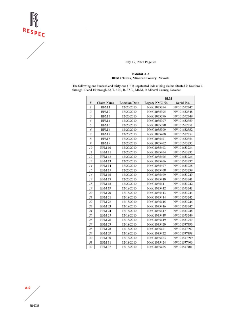
| RSI-3732 A-3 2 |
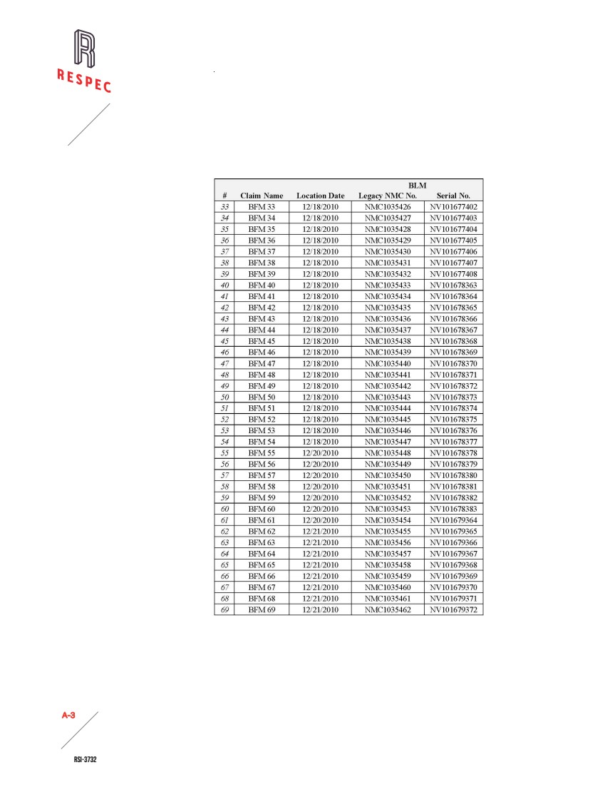
| RSI-3732 A-4 2 |
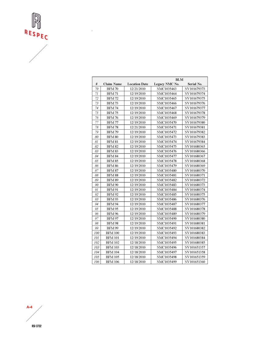
| RSI-3732 A-5 2 |
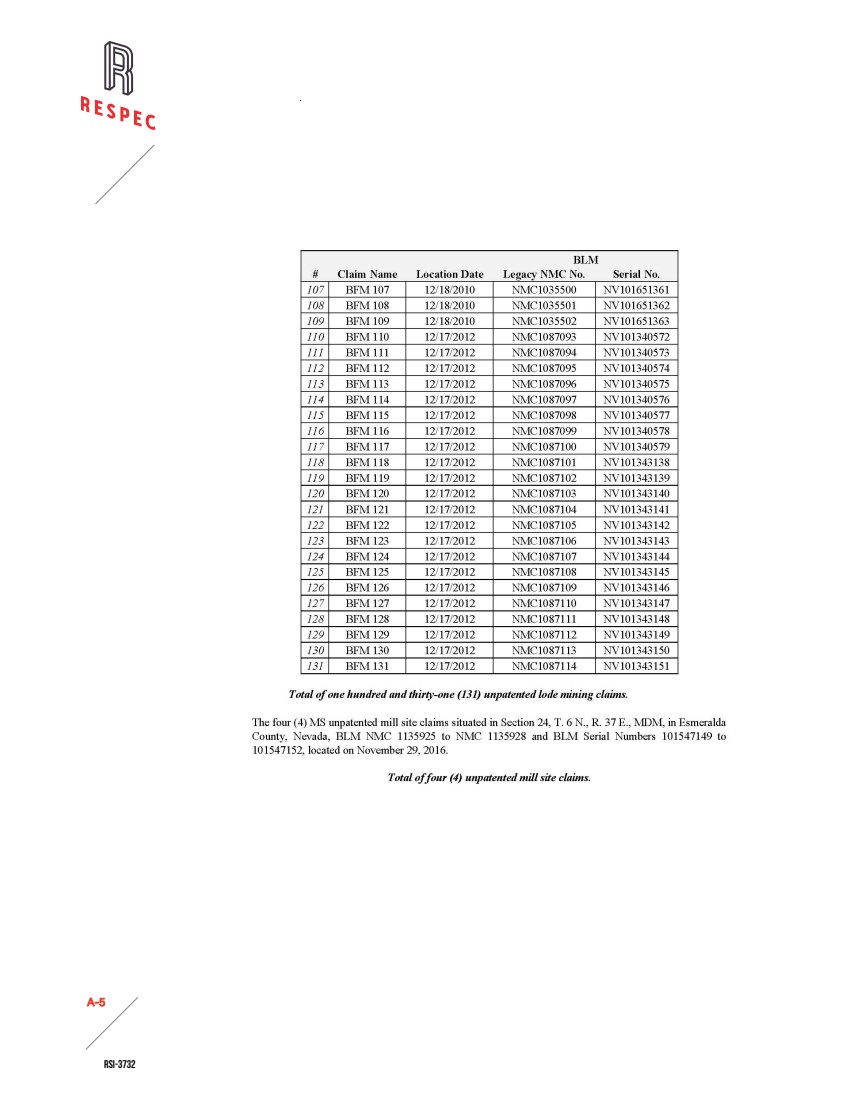
| RSI-3732 A-6 2 |
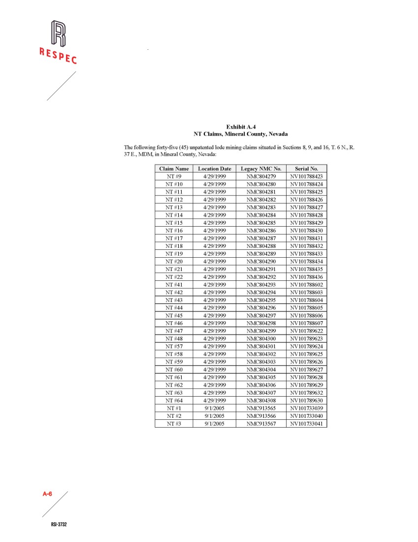
| RSI-3732 A-7 2 |