
Exhibit 99.23
 |  |
TECHNICAL REPORT ON THE SAN LUIS PROPERTY
District of Shupluy, Yungay Province, Ancash Department, Peru
Effective Date: January 15, 2025
Report Date: March 14, 2025
Report prepared for Highlander Silver Corp.
By Martin Mount, MSc MCSM FGS CGeol FIMMM CEng
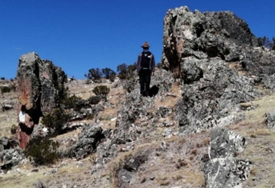
Photograph
of the Ayelén Vein cropping out at surface
(latitude 09° 23’ south by longitude 77° 47’ west)
| Technical Report on the San Luis Property | 1 |
DATE AND SIGNATURE PAGE
I, Martin Mount, MSc MCSM FGS CGeol FIMMM CEng (Qualified Person), do hereby certify that I am author of the report entitled “Technical Report on the San Luis Property” with the effective date of January 15, 2025.
| ● | My current work address is Avenida 28 de Julio 842-A, Miraflores, Lima, Peru, 15074. |
| ● | I am a self-employed independent Mining Geologist and Mine Planning Engineer. |
| ● | I graduated with a Distinction in Master of Science in Mining Geology at the Camborne School of Mines, UK in 1985. |
| ● | I have worked in the mining industry for more than 50 years. I specialize in the geological control, management and evaluation of exploration and base metal and Au-Ag mining projects. I have significant relevant experience in mineral resource estimation including, in addition to much other relevant experience, a five year period with Volcan Compañia Minera S.A.A., where my principal role was the ‘Competent Person’ for reporting Resources and Reserves (JORC Code), and where I was responsible for geological interpretation, modelling and planning in mining operations at the following underground mines: Carahuacra, San Cristobal, Andaychagua, Ticlio, Animon, Vinchos and Cerro de Pasco. I have read the definition of “Qualified Person” set out in National Instrument 43-101 (“NI 43-101”) and certify that by reason of my education, affiliation with professional associations (as defined in NI 43-101) and past relevant work experience, I fulfil the requirements to be a “Qualified Person” for the purposes of reporting under NI 43-101. |
| ● | I am responsible for the preparation of all sections of this Technical Report. |
| ● | I am independent of Highlander Silver Corp. (the Issuer) applying all of the tests in section 1.5 of National Instrument 43-101. |
| ● | I have had no prior involvement with the property that is the subject of this technical report. |
| ● | I have read NI 43-101 and Form 43-101F1, and the Technical Report has been prepared in compliance with that instrument and form. |
| ● | I visited the San Luis Properties on March 20–22, 2024. |
| ● | I consent to the filing of the Technical Report with any stock exchange and other regulatory authority and any publication by them for regulatory purposes, including electronic publication in the public company files on their websites accessible by the public, of the Technical Report. |
| ● | At the effective date of the technical report, to the best of my knowledge, information, and belief, the technical report contains all scientific and technical information that is required to be disclosed to make the technical report not misleading |
Dated this 14th day of March, 2025.
(signed) Martin Mount
Martin Mount
MSc MCSM FGS CGeol FIMMM CEng (QP)
Fellow of the Geological Society of London – Membership No. 16658.
Fellow of the Institute of Materials Minerals and Mining – Membership No. 47566
| Technical Report on the San Luis Property | 2 |
CONTENTS
| 1 | SUMMARY | 11 | ||
| 1.1 | Geological Setting | 11 | ||
| 1.2 | Exploration to Date | 11 | ||
| 1.3 | 2025 Mineral Resource Estimate | 12 | ||
| 1.4 | Conclusions and Recommendations | 12 | ||
| 1.4.1 | Recommendations | 13 | ||
| 2 | INTRODUCTION | 14 | ||
| 2.1 | Units of Measure | 14 | ||
| 2.2 | Abbreviations | 14 | ||
| 3 | RELIANCE ON OTHER EXPERTS | 16 | ||
| 4 | PROPERTY DESCRIPTION AND LOCATION | 17 | ||
| 4.1 | Permitting | 19 | ||
| 4.2 | Annual Fees and Obligations | 20 | ||
| 4.2.1 | Licence Fees | 20 | ||
| 4.2.2 | Minimum Production Obligation | 20 | ||
| 4.3 | Ownership of Mining Rights | 21 | ||
| 4.4 | Royalties Payable | 21 | ||
| 4.4.1 | Royalties Payable to Third Parties | 22 | ||
| 4.5 | Taxation and Foreign Exchange Controls | 23 | ||
| 4.6 | Protected Areas | 24 | ||
| 4.7 | Rights to Conduct Exploration Activities | 25 | ||
| 5 | ACCESSIBILITY, CLIMATE, LOCAL RESOURCES, INFRASTRUCTURE AND PHYSIOGRAPHY | 26 | ||
| 5.1 | Accessibility | 26 | ||
| 5.2 | Climate | 27 | ||
| 5.3 | Local Resources | 27 | ||
| 5.4 | Infrastructure | 27 | ||
| 5.5 | Physiography | 28 | ||
| 5.6 | Water Resources | 29 | ||
| 6 | HISTORY | 30 | ||
| Technical Report on the San Luis Property | 3 |
| 7 | GEOLOGICAL SETTING AND MINERALIZATION | 31 | ||
| 7.1 | Regional Geology | 31 | ||
| 7.1.1 | Cordillera Negra Mountain Range | 32 | ||
| 7.1.2 | Huaylas Valley | 33 | ||
| 7.1.3 | Cordillera Blanca Mountain Range | 33 | ||
| 7.1.4 | Structure | 33 | ||
| 7.2 | Property Geology | 33 | ||
| 7.2.1 | Lithology | 34 | ||
| 7.2.2 | Structure | 38 | ||
| 7.2.3 | Alteration | 39 | ||
| 7.3 | Mineralization | 40 | ||
| 7.3.1 | San Luis Vein System | 40 | ||
| 7.3.2 | Vein Mineralogy | 41 | ||
| 7.3.3 | Zinc-Copper-Lead-Silver (± Gold) Manto Mineralization of the BP Zone | 47 | ||
| 7.3.4 | Hydrothermal Breccia-Hosted Copper-Lead-Zinc-Silver Mineralization | 48 | ||
| 7.3.5 | Copper-Molybdenum Porphyry-Type Mineralization | 50 | ||
| 7.3.6 | Mineralogical/Petrographic Studies | 51 | ||
| 8 | DEPOSIT TYPES | 53 | ||
| 8.1 | Deposit Classification | 53 | ||
| 8.1.1 | Epithermal Low-Sulphidation Precious Metal Vein Mineralization | 53 | ||
| 8.1.2 | Copper-Molybdenum Porphyry and Related Base Metal Mineralization (BP Zone) | 54 | ||
| 8.1.3 | Sillitoe Opinion | 55 | ||
| 9 | EXPLORATION | 57 | ||
| 9.1 | Exploration Program (2005) | 57 | ||
| 9.2 | Exploration Program (2006) | 57 | ||
| 9.2.1 | Geological Mapping | 57 | ||
| 9.2.2 | Rock Geochemical Sampling | 57 | ||
| 9.3 | 2007 Exploration Program (2007) | 59 | ||
| 9.3.1 | Infrastructure Construction | 59 | ||
| 9.3.2 | Geological Mapping | 59 | ||
| 9.3.3 | Silt Geochemical Sampling | 59 | ||
| 9.3.4 | Rock Geochemical Sampling | 59 | ||
| 9.3.5 | Geophysical Surveying | 60 | ||
| 9.3.6 | Diamond Drilling | 61 | ||
| 9.4 | Summarized Results of 2006–2007 Exploration Drilling Programs | 61 | ||
| 9.5 | Engineering Drillhole and Site Investigation Work carried out in 2010 | 62 | ||
| 9.6 | Exploration Program (2011–2012) | 62 | ||
| 9.7 | Exploration Restart (2021–2023) | 67 | ||
| Technical Report on the San Luis Property | 4 |
| 10 | DRILLING | 72 | ||
| 10.1 | Results of the 2006–2007 Drilling Programs | 74 | ||
| 11 | SAMPLE PREPARATION, ANALYSIS AND SECURITY | 80 | ||
| 11.1 | Surface Trench Sampling | 80 | ||
| 11.2 | Drill Core Sampling | 80 | ||
| 11.3 | Sample Security and Chain of Custody Procedures | 80 | ||
| 11.4 | Sample Preparation and Analysis | 81 | ||
| 11.4.1 | Sample Preparation | 81 | ||
| 11.4.2 | Analyses | 81 | ||
| 11.4.3 | Quality Assurance and Quality Control | 82 | ||
| 12 | DATA VERIFICATION | 87 | ||
| 12.1 | Verification of Surface Sampling Trenches and Drillhole Collars | 87 | ||
| 12.1.1 | Trenches | 87 | ||
| 12.1.2 | Drillhole Collars | 88 | ||
| 12.2 | Verification of Drill Core Logging | 89 | ||
| 12.3 | Verification of Assay Results | 91 | ||
| 13 | MINERAL PROCESSING AND METALLURGICAL TESTING | 96 | ||
| 13.1 | Process Research Associates, Vancouver, Canada | 96 | ||
| 13.2 | Plenge Laboratory, Lima, Perú | 98 | ||
| 13.3 | G&T Metallurgical Services Ltd | 99 | ||
| 13.3.1 | Comminution and Settling Tests by G&T | 100 | ||
| 13.4 | Feasibility Study by BISA | 101 | ||
| 13.5 | Conclusions | 101 | ||
| 14 | MINERAL RESOURCE ESTIMATES | 103 | ||
| 14.1 | Review of the 2009 Mineral Resource Estimate | 103 | ||
| 14.1.1 | Databases | 103 | ||
| 14.1.2 | Drill Core vs Chip-Channel Sampling Quality | 105 | ||
| 14.2 | Geological Domains and Modelling | 105 | ||
| 14.3 | Outlier Treatment | 108 | ||
| 14.4 | Sample Lengths | 109 | ||
| 14.5 | Block Model Parameters | 109 | ||
| 14.6 | Gold and Silver Grade Estimation | 110 | ||
| 14.7 | Bulk Density | 113 | ||
| 14.8 | Resource Classification | 113 | ||
| Technical Report on the San Luis Property | 5 |
| 14.9 | Block Model Validation | 114 | ||
| 14.9.1 | Statistics | 114 | ||
| 14.9.2 | Swath Plots | 116 | ||
| 14.9.3 | Estimation Software Checks | 117 | ||
| 14.9.4 | Visual Checks | 117 | ||
| 14.10 | Reasonable Prospects for Economic Extraction | 117 | ||
| 14.11 | Mineral Resource Statement | 118 | ||
| 15 | MINERAL RESERVE ESTIMATES | 121 | ||
| 16 | MINING METHODS | 122 | ||
| 17 | RECOVERY METHODS | 123 | ||
| 18 | PROJECT INFRASTRUCTURE | 124 | ||
| 19 | MARKET STUDIES AND CONTRACTS | 125 | ||
| 20 | ENVIRONMENTAL STUDIES, PERMITTING AND SOCIAL OR COMMUNITY IMPACT | 126 | ||
| 21 | CAPITAL AND OPERATING COSTS | 127 | ||
| 22 | ECONOMIC ANALYSIS | 128 | ||
| 23 | ADJACENT PROPERTIES | 129 | ||
| 24 | OTHER RELEVANT DATA AND INFORMATION | 130 | ||
| 25 | INTERPRETATION AND CONCLUSIONS | 131 | ||
| 25.1 | Geological Model and Supporting Data | 131 | ||
| 25.2 | Mineral Resource Estimation | 131 | ||
| 25.3 | Exploration Objectives | 131 | ||
| 25.4 | Project Development | 131 | ||
| 25.5 | Conclusions | 132 | ||
| 26 | RECOMMENDATIONS | 133 | ||
| 26.1 | Exploration | 133 | ||
| 26.2 | Geological Modelling and Resource Estimation | 133 | ||
| 26.3 | Community and Social Engagement | 134 | ||
| 26.4 | The Proposed Exploration Program | 134 | ||
| 27 | REFERENCES | 136 | ||
| Technical Report on the San Luis Property | 6 |
Tables
| Table 1-1 | 2025 San Luis Project updated Mineral Resource estimate | 12 |
| Table 1-2 | Recommended Work Program | 13 |
| Table 4-1 | Summary of Reliant’s 32 mineral concessions registered with MINEM | 18 |
| Table 4-2 | Royalties payable to the Peruvian Government | 22 |
| Table 4-3 | Summary of concessions where 1% NSR Royalty is payable to ESC | 22 |
| Table 4-4 | Summary of the concessions where 1% NSR Royalty is payable to Metalla Royalty & Streaming Ltd | 23 |
| Table 4-5 | Summary of the concessions where 4% NSR Royalty is payable to SSR Mining Inc | 23 |
| Table 4-6 | Summary of rates – Special Tax on Mining | 24 |
| Table 9-1 | Summary of surface trenches by vein target area | 58 |
| Table 9-2 | Highlights from veins mapped during 2021-2023 | 69 |
| Table 10-1 | Summary of 2006–2012 diamond drilling | 72 |
| Table 10-2 | Summary of the main drillhole logged lithologies | 77 |
| Table 11-1 | Accepted gold values and ranges for the San Luis standards | 82 |
| Table 11-2 | Accepted silver values and ranges for the San Luis standards | 82 |
| Table 12-1 | Summary of drill collars checked on site | 89 |
| Table 12-2 | Summary of drill cores inspected within Model Section 10 | 89 |
| Table 12-3 | Summary of drill cores inspected within Model Section 14 | 89 |
| Table 12-4 | Summary of drill cores inspected within Model Section 20 | 90 |
| Table 12-5 | Summary of surrounding drill cores inspected to the north, south and in depth | 91 |
| Table 12-6 | Summary of the check assay results carried out for HSC | 94 |
| Table 12-7 | Assay results for the inserted control samples | 95 |
| Table 13-1 | Summary of composite samples provided to PRA | 96 |
| Table 13-2 | Cyanidation results with and without gravity pre-concentration | 96 |
| Table 13-3 | PRA results showing the effect of grind size on recoveries | 97 |
| Table 13-4 | Summary of the composite sample make-up provided to Plenge | 98 |
| Table 13-5 | Plenge results showing the effect of grind sizes on recoveries | 98 |
| Table 13-6 | G&T settling test results | 101 |
| Table 14-1 | 2009 Reliant-declared Mineral Resource estimate (6.0 g/t Au cut-off) | 103 |
| Table 14-2 | Summary of trench sampling and metres assayed | 103 |
| Table 14-3 | Summary of diamond drillholes and metres sampled and assayed | 104 |
| Table 14-4 | Paired core vs chip-channel sample grades | 105 |
| Table 14-5 | Block model parameters | 110 |
| Table 14-6 | Search parameters used in block interpolation | 110 |
| Table 14-7 | Sample statistics for gold, before and after capping | 112 |
| Table 14-8 | Sample statistics for silver, before and after capping | 112 |
| Table 14-9 | Specific gravity measurements in the Ayelén zone | 113 |
| Table 14-10 | Statistics comparing 1 m composite samples to Resource Model block grades | 115 |
| Table 14-11 | San Luis Project Mineral Resources estimated in 2025 | 118 |
| Table 14-13 | Summary by vein – comparison 2009 with this 2025 estimate | 119 |
| Table 14-14 | Summary of the Indicated Resources by Elevation | 120 |
| Technical Report on the San Luis Property | 7 |
Figures
| Figure 4-1 | Location of the San Luis Property in Ancash, Peru | 17 |
| Figure 4-2 | Landsat image showing the distribution of Reliant’s 32 mining concessions | 19 |
| Figure 5-1 | Map showing the road network and accessibility of the San Luis Project | 26 |
| Figure 5-2 | San Luis exploration camp at 3,705 masl, with the canteen to the left, accomodation in the centre, and core shed to the right | 27 |
| Figure 5-3 | Partly installed San Luis construction camp at 4,000 masl | 28 |
| Figure 5-4 | Map showing the camp locations and four lagoons within the project area | 29 |
| Figure 7-1 | Map showing the regional geological setting and the north-northwest trend of faulting, and the Tertiary Volcanic Belt, carrying high-sulphidation epithermal (Pierina), low-sulphidation epithermal (San Luis) deposits and skarns | 32 |
| Figure 7-2 | Reliant’s regional geology and target generation map based on stream sediment sampling | 34 |
| Figure 7-3 | Stratigraphic column for the Ayelén District (developed by Reliant) | 35 |
| Figure 7-4 | Left – Dark grey, sub-horizontal andesitic flows (photo centre) near Inés vein structure. Right – Drill core of fine to medium-grained, feldspar-phyric andesite that constitutes portions of andesitic flow unit (coded V4, V4m (massive), V4mg (medium-grained) and V4fp (feldspar-porphyritic in drill logs) | 35 |
| Figure 7-5 | Heterolithic andesitic tuff-breccia with majority of poorly sorted andesitic volcanic clasts (left); Close-up of tuff breccia with black shale clasts (coded V4tbx in drill logs) (right) | 36 |
| Figure 7-6 | Left – Outcrop of pyroclastic flow rock with lapilli-sized, andesite and dacite volcanic clasts, and dark green, chloritized andesite pumice fragments partially compressed to form fiamme (coded V4pmt or V4lpt when pumice clasts are minor or absent). Right – Outcrop of coarse-grained andesitic crystal-lithic tuff (coded V4xlt in drillhole logs) exposed immediately west of the Ayelén vein structure | 37 |
| Figure 7-7 | Satellite image of the San Luis vein system (modified after Pincus and McCrea, 2007) | 41 |
| Figure 7-8 | Left – Drill core samples showing typical multiple brecciation and epithermal vein textures of the Ayelén vein. Thin laminations and colloform banding of quartz, chalcedony, sericite, calcite and minor adularia. Right – Drill core (DDH A-SL-064) hosting grey bands of very fine-grained pyrite with electrum, acanthite and base metal sulphides | 42 |
| Figure 7-9 | Geology of the Ayelén and Inés vein structures (modified from Pincus and McCrea, 2006) | 43 |
| Figure 7-10 | Satellite image of the San Luis vein and BP zones (after Ferraris, 2007) | 47 |
| Figure 7-11 | Patacocha manto occurrence (highlighted as white lines), after Ferraris, 2007 (left); Quartz-calcite stockwork hosted by andesitic rocks beneath manto occurrences (right) | 48 |
| Figure 7-12 | Aerial view of Patacocha hydrothermal vein outcrops (yellow lines) (left); Outcrop of hydrothermal breccia (right) | 49 |
| Figure 7-13 | Representative drill core samples from drillhole BP-SL-131, Patoccocha breccia, BP zone | 50 |
| Figure 7-14 | Native gold grain filling up porosities in the pyrite (py); the biggest grain measures 0.02 mm | 52 |
| Figure 8-1 | The epithermal model (Hedenquist et al., 1996, 2000, 2005 and others) | 54 |
| Figure 8-2 | Schematic geological section of inferred BP zone porphyry copper centre | 56 |
| Figure 9-1 | Hand-excavated trench with spray-painted locations of individual channel samples (after Pincus and McCrea, 2006) (left); Locations of 2006 channel samples on central portion of Ayelén vein structure (after Reliant, 2007) (right) | 58 |
| Figure 9-2 | Plans of resistivity (left) and chargeability (right), depth of 100 m, BP zone | 60 |
| Figure 9-3 | Geologic map showing gold and silver geochemical values from the 2011 Bonita target sampling and the 2012 BP zone sampling, location of the adits and trenches of the former Esperanza mine, Yanacota and San Simon prospects, and a noted breccia target | 63 |
| Figure 9-4 | Geological map showing the south extension of the copper-molybdenum target in the BP zone with an off-centre unaltered granodiorite and feldspar-phyric intrusion, copper and molybdenum values from 2012 sampling, the limits of the molyndenum anomalies, and location of 2013 proposed drillholes | 64 |
| Figure 9-5 | 2011–2012 Bonita trench sampling results and location of the first drillhole | 66 |
| Figure 9-6 | Two initial diamond drillholes drilled across the Bonita vein system | 67 |
| Technical Report on the San Luis Property | 8 |
| Figure 9-7 | Extent of vein mapping during 2021-2023 within the area surrounding the Ayelén occurrence | 68 |
| Figure 9-8 | Crop out of the Gemela West Vein approximately 1 km northeast of the Ayelén zone (right-hand inset photograph shows the vein in more detail) | 69 |
| Figure 9-9 | Two cross-sections through the Ayalén and Inés veins indicating a possible relationship between the mineralization and the faulted juxtaposition of the Upper Volcanics | 70 |
| Figure 9-10 | Northeast-southwest cross section showing the relationship between mineralization, faulting, and lithology adjacent to the Ayelén vein may be repeated in the case of the Ayelén West and Carhuan Puquio veins further to the west and southWest, and where drilling is being considered | 70 |
| Figure 10-1 | 2006 drillhole locations re the Ayelén and Inés vein structures | 73 |
| Figure 10-2 | Drilling section 1675 north showing the interpreted Ayelén vein and dyke structures | 75 |
| Figure 10-3 | Drilling section 1825 north showing the interpreted Ayelén and Inés veins, and dyke structures | 76 |
| Figure 11-1 | Duplicate core sample assays – Au ppm scatterplot | 84 |
| Figure 11-2 | Duplicate core sample assays – Ag ppm scatterplot | 84 |
| Figure 11-3 | 2007 duplicate core sample assay results for gold (left); 2007 duplicate core sample assay results for silver (right) | 85 |
| Figure 11-4 | Duplicate core sample assays – Au ppm relative difference chart | 85 |
| Figure 11-5 | Duplicate core sample assays – Ag ppm relative difference chart | 86 |
| Figure 12-1 | Ayelén trench 13 (left) and Ayelén trench 10 (right) | 87 |
| Figure 12-2 | Checking coordinates for two of the drillhole collars | 88 |
| Figure 12-3 | Collar to SL06-15 (left) and collar to SL06-14 (right) | 88 |
| Figure 12-4 | Sawn core from drillhole SL06-02 shows sampling continuing beyond the vein boundary | 90 |
| Figure 12-5 | Documented, bagged and sealed coarse sample rejects on wooden pallets | 91 |
| Figure 12-6 | A well numbered separate assay pulp sample store at Chorrillos | 92 |
| Figure 12-7 | Access to the computerized database can locate sample pulps within minutes | 93 |
| Figure 14-1 | South-north section of the drillhole intersections along the Ayelén vein | 104 |
| Figure 14-2 | 3D wireframe models including Ayelén, Ayelén HW and Inés | 106 |
| Figure 14-3 | 3D wireframe models showing high-grade domains | 107 |
| Figure 14-4 | Ayelén vein – distribution of gold grades (left) and distribution of silver grades (right) | 107 |
| Figure 14-5 | Ayelén vein – distribution of true widths (left) and distribution of width x AuEq grades (right) | 108 |
| Figure 14-6 | Gold log-probability plots for vein samples showing the determined capping values | 108 |
| Figure 14-7 | Silver log-probability plots for vein samples showing the determined capping values | 109 |
| Figure 14-8 | Histogram of sample interval lengths inside vein intercepts | 109 |
| Figure 14-9 | Box plot for gold for vein samples within different domains | 110 |
| Figure 14-10 | Box plot for silver for vein samples within different domains | 111 |
| Figure 14-11 | Gold histogram for different domains – all veins | 111 |
| Figure 14-12 | Silver histogram for different domains – all veins | 111 |
| Figure 14-13 | East-facing long sections of Ayelén, Ayelén HW and Inés showing Mineral Resource categories, surface trench and drillhole intercept spacing | 114 |
| Figure 14-14 | Ayelén vein gold – elevation and northing swath plots for different domains | 116 |
| Figure 14-15 | Ayelén vein silver – elevation and northing swath plots for different domains | 116 |
| Figure 14-16 | Gold – full width comparison between vein intercepts and block model | 117 |
| Figure 14-17 | Silver – full width comparison between vein intercepts and block model | 117 |
| Technical Report on the San Luis Property | 9 |
Appendices
| Appendix A | Summary of San Luis Project Sampling Trenches |
| Appendix B | Summary of San Luis Project Diamond Drillholes |
| Appendix C | San Luis Project – Summary of Main Drillhole Intercepts and Trench Sampling Results |
| Appendix D | Assay Certificates for the Check Assays carried out for Highland Silver Corp. |
| Technical Report on the San Luis Property | 10 |
| 1 | SUMMARY |
The San Luis Property is situated within the District of Shupluy, Yungay Province, Ancash Department of west-central Peru; approximately 513 km north-northwest of the city of Lima. The geographic centre of the property is at 09o23’ south latitude by 77o47’ west longitude, or Universal Transverse Mercator (UTM) 8,960,000 m north by 195,000 m east within Peruvian National Topographic System (NTS) map sheet 19-H. Reliant Ventures S.A.C. (“Reliant”) has been exploring this property since its discovery in June 2005.
On May 23, 2024, Highlander Silver Corp. (the “Company” or “HSC”) announced that it had acquired the San Luis Gold-Silver Project (the “San Luis Property”) from SSR Mining Inc. (“SSR Mining”), pursuant to a share purchase agreement dated November 29, 2023 (as amended, the “Share Purchase Agreement”).
The San Luis Property comprises 32 mineral rights which cover an area of approximately 23,298 ha. Out of these mineral rights, 31 are held by Reliant, while the remaining 1 is a recently staked claim held by CAPPEX Exploraciones S.A.C., (both subsidiaries of the Company), that the Company anticipates transferring to Reliant in due course.
| 1.1 | Geological Setting |
The San Luis Property is situated regionally within the Cordillera Negra terrain of the Peruvian Andes. It is dominantly underlain by volcanic, volcanoclastic and sub-volcanic intrusive rocks of andesitic-dacitic to rhyolitic composition belonging to the Paleocene-age Calipuy Formation. The Lower Cretaceous Santa Formation of limestone and calcareous clay crops out locally as ‘windows’ within the younger overlying volcanic rocks and there are exposures of the Coastal batholith in the southwestern portion of the property.
North to northwesterly trending fault structures are the most important structural features within the property since they appear to control and host most of the known precious metal-bearing vein structures. Northwesterly and north-northwesterly trending faults, especially those hosting vein structures, have been repetitively active since the cessation of volcanism. Faulting and shearing have also occurred during and after vein emplacement resulting in well-developed vein breccia textures, open tensional sites for later dyke emplacement, and later brecciation and displacement of both the dykes and vein structures.
| 1.2 | Exploration to Date |
Three distinctly different mineral deposit types have been identified within the property. The most extensively explored are the epithermal, low sulphidation, gold and silver-bearing, quartz-calcite veins of the Ayelén system first discovered in 2005. The others, hydrothermal breccia-hosted base metal and manto-hosted occurrences, appear related to a buried intrusion situated centrally within what is referred to as the BP zone explored in the period 2010–2012, and centred approximately 6 km southeast of the Ayelén vein system.
A similar gold-bearing Bonita vein system was located 7 km to the south of the Ayelén occurrence in 2011-2012. Trenching and two preliminary drillholes confirmed anomalous gold-silver values.
| Technical Report on the San Luis Property | 11 |
| 1.3 | 2025 Mineral Resource Estimate |
The principal objective of this technical report was to review Reliant’s 2009 Mineral Resource estimates and supporting data on behalf of HSC, and prepare this independent updated estimate as summarized in Table 1-1.
| Table 1-1 | 2025 San Luis Project updated Mineral Resource estimate |
| San Luis Project Mineral Resources – 3D model | ||||||
| Vein | Resource Category | Tonnes | Grade (g/t) | Contained ounces | ||
| Au | Ag | Au | Ag | |||
| Ayelén | 353,602 | 28.83 | 655.2 | 327,798 | 7,448,012 | |
|
Ayelén HW Inés |
Indicated |
72,462 27,720 |
9.94 5.93 |
348.0 209.8 |
23,163 5,282 |
810,798 186,999 |
| Subtotal | 453,784 | 24.42 | 578.9 | 356,243 | 8,445,809 | |
| Ayelén | 41,911 | 5.39 | 208.3 | 7,260 | 280,725 | |
|
Ayelén HW Inés |
Inferred |
6,511 3,280 |
3.18 2.31 |
170.9 185.9 |
666 244 |
35,770 19,598 |
| Subtotal | 51,702 | 4.92 | 202.2 | 8,170 | 336,093 | |
Notes:
| ● | Mineral Resources are not Mineral Reserves and do not have demonstrated viability. |
| ● | All tonnages reported are Dry Metric Tonnes, and contained gold and silver are reported in Troy Ounces. |
| ● | Mineral Resources are estimated at a cut-off grade of 3 g/t AuEq that considers bullion prices of US$1,700/oz gold and US$20/oz silver, and process recoveries of 90% for both gold and silver. |
| ● | The AuEq content has been calculated as follows: AuEq = Au+0.0117647*Ag. |
| ● | Numbers in the above table have not been rounded to ensure consistency in calculations and summations. However, readers should consider that due to estimation uncertainty, the report numbers are not reliable beyond three significant figures for Indicated Resources, and two significant figures for Inferred Resources. |
| ● | The effective date of the mineral resource estimate is January 15, 2025. |
| 1.4 | Conclusions and Recommendations |
Exploration to date has demonstrated that the main property opportunity comprises the continued exploration for epithermal, low sulphidation, gold and silver bearing veins in order to increase property value, and it is recommended that further exploration be carried out.
The exploration objectives are clear and require more exploration to grow the current Mineral Resources and make new discoveries that could support further growth beyond this, with the priorities as follows:
| 1) | Continue with property-wide exploration for additional gold-silver bearing veins, including in the southeast catchment that has returned highly anomalous stream sediment samples although these have not yet been prospected or mapped. |
| 2) | Continue drilling in the Bonita vein to test the strike and depth extent of mineralization beyond the single section currently tested by drilling and also, advance prospecting, mapping and sampling in the Bonita area to identify any other veins and follow-up with trenching to support drill-testing these veins. |
| Technical Report on the San Luis Property | 12 |
| 1.4.1 | Recommendations |
A two-phase work program is proposed, with a total estimated cost of US$10 million, which includes a 15% contingency. A summary of the program along with detailed cost estimates is provided in Table 26- 1.
Phase 1 focuses on ground base discovery exploration work of Au/Ag veins to the south of Ayelén and in the area between Ayelén and Bonita, together with early delineation of resource potential in Bonita.
This phase is projected to require US$1.7 million and includes the following recommendations:
| ● | Executing fieldwork on known untested veins and new targets for precise evaluation and prioritization. |
| ● | Initiation of drilling at Bonita, targeting priority zones within the known strike extent of the vein system. |
The extent of Phase 2 is partially contingent upon favourable results from Phase 1. The estimated cost for this second phase is approximately US$8.3 million, which will cover:
| ● | Extensive diamond drilling for resource definition and extension in Bonita |
| ● | Initial discovery and resource outlining of new targets |
Table 1-2 – Recommended Work Program
| Phase/Area | Phase 1 | Phase 2 | ||
| Activity | Budget US$ | Activity | Budget US$ | |
| Bonita Vein | Mapping, Trenching & Discovery & Resource outline drilling (~2500 m) | 850,000 |
Resource drilling (~4000 m) |
1,300,000 |
| Ayelen South Trend Veins | Geochemistry, Geological Mapping, Geophysics | 300,000 |
Discovery and extensional drilling and initial resource outline (~8000 m)
|
3,250,000 |
| New Target Generation | Geochemistry, Geological Mapping, Geophysics | 150,000
|
Discovery drilling and initial Resource outline of top Priority targets (~6000 m)
|
2,000,000 |
| Community and Social Engagement/Permitting | Community programs and infrastructure development | 150,000
|
Community programs and infrastructure development | 700,000 |
| Sub Total | 1,450,000 |
7,250,000 | ||
| Contingency 15% | 217,500 | 1,087,500 | ||
| Total | 1,667,500 | 8,337,500 | ||
| Total USD $ | 10,005,000 | |||
| Technical Report on the San Luis Property | 13 |
| 2 | INTRODUCTION |
The QP was retained by HSC in 2024 to conduct a review of the Mineral Resource estimate and supporting dn Luis Property, for the purposes of preparing a Technical Report following the guidelines of Canadian National Instrument 43-101 Standards of Disclosure for Mineral Projects (NI 43-101).
This work involved a property visit carried out on March 20-21, 2024, examination of various mineral occurrences on the property, verification of drilling and sampling, data validation, review of the geological model and the previous Mineral Resource estimate and classification of NI 43-101-compliant Mineral Resources according to the guidelines set out by the Canadian Institute of Mining, Metallurgy and Petroleum (CIM). An inspection of Reliant’s sample store (coarse rejects and assay pulps) was made on March 22, 2024, in Chorrillos, Lima.
This report complies with the disclosure and reporting requirements set forth in NI 43-101, Companion Policy 43-101CP to NI 43-101, and Form 43-101F1 of NI 43-101.
| 2.1 | Units of Measure |
The metric system has been used throughout this report. Tonnes are dry metric of 1,000 kg, or 2,204.6 lb. All currency is in United States dollars and referenced as ‘US$’ unless otherwise stated.
| 2.2 | Abbreviations |
| Abbreviation | Description |
| ° | degrees |
| °C | degrees Celsius |
| µm | micron(s) |
| 3D | three-dimensional |
| AAS | atomic absorption spectroscopy |
| Ag | silver |
| Arce | Arce Geofisicos |
| Au | gold |
| AuEq | gold equivalent |
| CIM | Canadian Institute of Mining, Metallurgy and Petroleum |
| cm | centimetres |
| CRM | certified reference material |
| Cu | silver |
| CV | coefficient of variation |
| Cwi | Crusher Abrasion Work index |
| DREM | Direction Regional de Energia y Minas |
| ESC | Esperanza Silver Corp. |
| ft | feet (or foot) |
| g | grams |
| Technical Report on the San Luis Property | 14 |
| Abbreviation | Description |
| G&T | G&T Metallurgical Services Ltd |
| g/cm3 | grams per cubic centimetre |
| g/t | grams per tonne |
| GPS | global positioning system |
| ha | hectares |
| HSC | Highlander Silver Corp. |
| ICP | inductively coupled plasma |
| ICP-OES | inductively coupled plasma-optical emission spectroscopy |
| INGEMMET | Peruvian Geological, Mining and Metallurgical Institute |
| kg | kilogram(s) |
| km | kilometres |
| km2 | square kilometres |
| kWh/t | kilowatt hours per tonne |
| lb | pound(s) |
| m | metre(s) |
| m2 | square metres |
| Ma | million years |
| masl | metres above sea level |
| MINEM | Peruvian Ministry of Energy and Mines |
| mm | millimetres |
| Mo | molybdenum |
| NI 43-101 | National Instrument 43-101 |
| NSR | net smelter return |
| NTS | National Topographic System |
| oz | troy ounce(s) |
| ppm | parts per million |
| PRA | Process Research Associates |
| QA | quality assurance |
| QAQC | quality assurance and quality control |
| QC | quality control |
| QP | Qualified Person |
| REI | Resource Evaluation Inc. |
| Reliant | Reliant Ventures S.A.C. |
| RMI | Resource Modeling Inc. |
| SD | standard deviation(s) |
| SSR Mining | SSR Mining Inc. (formerly Silver Standard Resources Inc.) |
| Stantec | Stantec International |
| US$ | United States dollars |
| UTM | Universal Transverse Mercator |
| Technical Report on the San Luis Property | 15 |
| 3 | RELIANCE ON OTHER EXPERTS |
The author of this current report is not qualified to provide comment on legal issues associated with the property included in Item 4 of this report. Inclusion of these aspects was based on a report provided by HSC’s counsel, Cillóniz & Valencia Abogados, confirmed current as of February 5, 2025, and has not been independently verified by the author. The author is therefore relying fully on such report as it pertains to legal matters disclosed in Item 4 of this report.
| Technical Report on the San Luis Property | 16 |
| 4 | PROPERTY DESCRIPTION AND LOCATION |
The San Luis Property is located in the high Andes of the Department of Ancash in Central Peru (Figure 4-1). The geographic centre of the property is at 09o23’ south latitude by 77o47’ west longitude, or UTM 8,960,000 m north by 195,000 m east within Peruvian NTS map sheet 19-H.
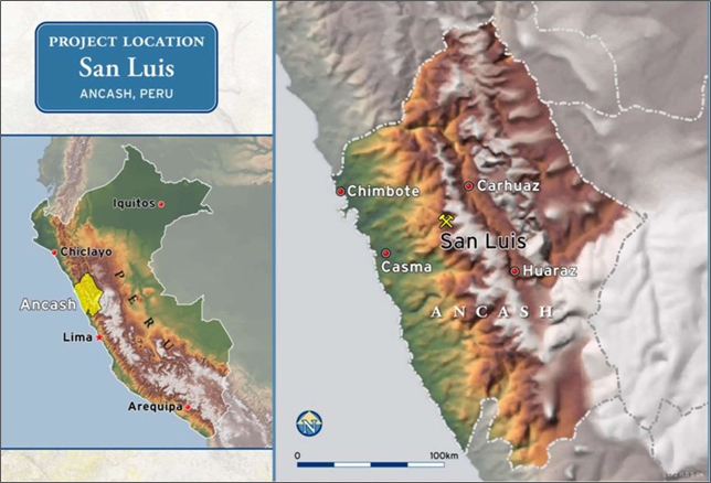
Figure 4-1 Location of the San Luis Property in Ancash, Peru
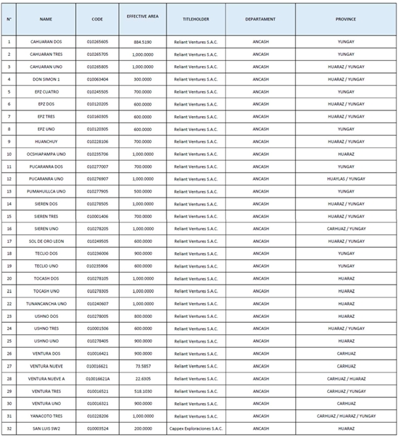
The property comprises 32 mineral rights covering an area of 23, 298.84 ha (Table 4-1 and Figure 4-2).
Out of the 32 mineral rights, a total of 31 have been granted definitive title to Reliant as metallic mining concessions, while the remaining mineral right (San Luis SW2) is a mining claim currently undergoing the corresponding titling procedure before INGEMMET.
All 31 titled mining concessions are registered and held under the name of Reliant, while CAPPEX Exploraciones S.A.C. (a subsidiary of the Company) is the titleholder of the San Luis SW2 mining claim. This concession is in the process of being transferred to Reliant.
The author understands that these mineral rights are in good standing, and he has not been made aware of any pending litigation or legal issues relating to the property. Mining concessions in Peru are irrevocable provided that their titleholder complies with the Maintenance Obligations referred to in Item 4.2. Except as set forth herein, the author is not aware of any other significant factors and risks that may affect access, title, or the right or ability to perform work on the property.
| Technical Report on the San Luis Property | 17 |
| Table 4-1 | Summary of Reliant’s 32 mineral concessions registered with MINEM. |
| Technical Report on the San Luis Property | 18 |
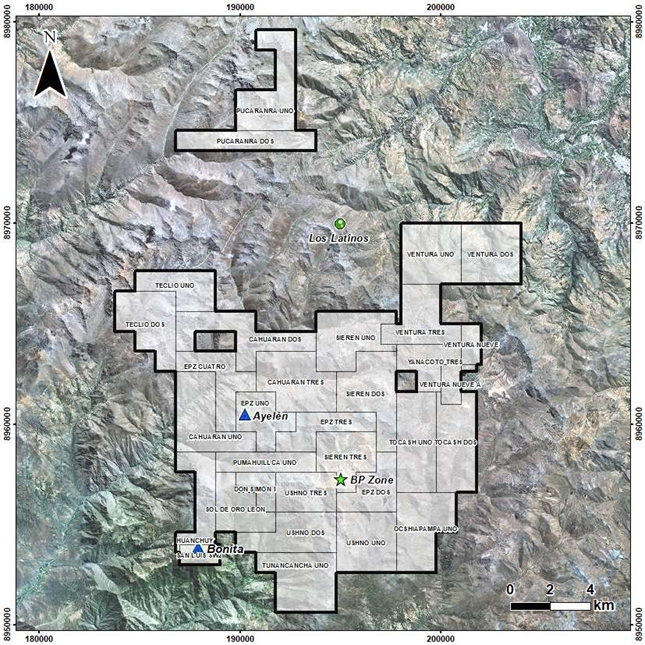
| Figure 4-2 | Landsat image showing the distribution of Reliant’s 32 mining concessions |
| 4.1 | Permitting |
Like other mining projects, San Luis is subject to various Peruvian mining laws, regulations and procedures. Mining activities in Peru are subject to the provisions of the Uniform Code of the General Mining Law (“General Mining Law”), which was approved by Supreme Decree No. 14- 92-EM, on June 4, 1992, and its subsequent amendments and regulations, as well as other related laws. Under Peruvian law, the Peruvian State is the owner of all mineral resources in the ground. The rights to explore for, develop and mine these mineral resources are granted by means of the “Concessions System”.
| Technical Report on the San Luis Property | 19 |
Mining concessions are considered immovable assets and are therefore subject to being transferred, optioned, leased and/or granted as collateral (mortgaged) and, in general, may be subject to any transaction or contract not specifically forbidden by law. Mining concessions may be privately owned and the participation in the ownership of the Peruvian State is not required. Buildings, workings and other permanent structures used in a mining operation are considered real property accessories to the concession on which they are situated.
| 4.2 | Annual Fees and Obligations |
| 4.2.1 | Licence Fees |
Pursuant to article 39 of the General Mining Law, titleholders of mining concessions must pay an Annual Licence Fee (Derecho de Vigencia). The Licence Fee is due on June 30 of each year and is set at US$3.00 per hectare. Failure to pay Licence Fees for two consecutive years causes the termination (caducidad) of the mining concession. According to article 59 of the General Mining Law, payment for one year may be delayed and the mining concessions will remain in good standing provided the outstanding payment is made before June 30 of the following year.
To the date of this report, with the sole exception of the San Luis SW2 mining claim, all 31 mining concessions making up the San Luis Project are currently two years behind in License Fee payments, meaning payment of the 2024 and 2025 License Fees is pending.
Failure by Reliant to comply with, at least, payment of the 2024 Licence Fees applicable to these concessions, on or before June 30, 2025, will result in the termination of the corresponding mining concessions.
In the case of San Luis SW2, this mining claim is one year behind in License Fee payments, meaning payment of the 2025 License Fees is pending.
| 4.2.2 | Minimum Production Obligation |
Legislative Decree 1010 dated May 9, 2008, Legislative Decree 1054 dated June 27, 2008, and Legislative Decree 1320 dated January 5, 2017, amended several articles of the General Mining Law referring to the Minimum Production Obligation, to the point of establishing a new regime for compliance with such Minimum Production Obligation (“New MPO Regime”).
According to the New MPO Regime, titleholders of metallic mining concessions must reach a minimum level of annual production (“Minimum Production”) of at least one (1) Tax Unit or “UIT” (UIT for the year 2025 was set at PEN5,350.00, approximately US$1,500) per hectare, within a period of 10 years, counted as from January 1st of the year following that in which title to concession was granted.
A mining concession that did not reach Minimum Production during the 10-year period mentioned above may remain in good standing for up to an additional 20 years, provided that the titleholder complies with payment of an annual Penalty payable until the year in which the mining concession reaches Minimum Production. The Penalty will be applied as from the year following that in which Minimum Production had to be reached.
The amount of the Penalty will be automatically increased every five years, as follows:
| ● | Failure to reach Minimum Production (Years 10 through 14): The Penalty will be equivalent to 2% of the applicable Minimum Production |
| Technical Report on the San Luis Property | 20 |
| ● | Failure to reach Minimum Production (Years 15 through 19): The Penalty will be equivalent to 5% of the applicable Minimum Production |
| ● | Failure to reach Minimum Production (Years 20 through 29): The Penalty will be equivalent to 10% of the applicable Minimum Production. |
Payment of the Penalty may be waived, on an annual basis, in case the titleholder incurs in qualified exploration investments in the mining concessions in the order of at least 10 times the amount of the applicable Penalty.
Failure to comply with payment of the applicable Penalty for two consecutive years will cause the termination of the mining concession.
Same as in the case of Licence Fees, in the case of Penalties payment for one year may be delayed and the mining concessions will remain in good standing provided the outstanding payment is made before June 30 of the following year.
Notwithstanding the above, in the event the titleholder does not reach Minimum Production within a period of 30 years counted as from the year following the year in which title to concession was granted, the mining concession will be terminated.
In the case of concessions granted title on or before October 10, 2008, the 10-year period for reaching Minimum Production began on January 1, 2009.
To the date of this report, a total of 26 out of the 31 mining concessions making up the San Luis Property are subject to Penalty payments. In all these cases, Penalties have been timely paid up until the year 2023.
Payment of the 2024 and 2025 Penalties is pending in the case of all the 26 mining concessions referred to above. Failure to comply with, at least, payment of the 2024 Penalties on or before June 30, 2025, will result in the termination of the corresponding mining concessions.
| 4.3 | Ownership of Mining Rights |
Pursuant to the General Mining Law:
| ● | Mining rights may be forfeited only due to a number of circumstances defined by law (i.e. non- payment of the license fees and/or non-compliance with the Minimum Production Obligation or Penalty payments). |
| ● | The right of concession holders to sell mine production freely in world markets is established. Peru has become party to agreements with the World Bank’s Multilateral Investment Guarantee Agency and with the Overseas Private Investment Corporation. |
| 4.4 | Royalties Payable |
Mine production in Peru is subject to a Royalty payable to the Government. The Royalty applies to gross sales and its percentage will depend on the company’s operating margin (income from sales of minerals minus production costs and operational expenses). Depending on the operating margin the royalty can range between 1% and 12% (Table 4-2). Royalty payments are tax deductible.
| Technical Report on the San Luis Property | 21 |
| Table 4-2 | Royalties payable to the Peruvian Government |
| No | Royalty
Trenches (Operating Margin divided by Gross Sales) |
Royalty (%) | |
| 1 | 0% | 10% | 1.00% |
| 2 | 10% | 15% | 1.75% |
| 3 | 15% | 20% | 2.50% |
| 4 | 20% | 25% | 3.25% |
| 5 | 25% | 30% | 4.00% |
| 6 | 30% | 35% | 4.75% |
| 7 | 35% | 40% | 5.50% |
| 8 | 40% | 45% | 6.25% |
| 9 | 45% | 50% | 7.00% |
| 10 | 50% | 55% | 7.75% |
| 11 | 55% | 60% | 8.50% |
| 12 | 60% | 65% | 9.25% |
| 13 | 65% | 70% | 10.00% |
| 14 | 70% | 75% | 10.75% |
| 15 | 75% | 80% | 11.50% |
| 16 | More than 80% | 12.00% | |
| 4.4.1 | Royalties Payable to Third Parties |
By public deed dated August 22, 2011, issued before notary public of Lima Anibal Sierralta Rios, Reliant granted SSR Mining Inc. (then called Silver Standard Resources Inc.) a perpetual 1% Net Smelter Return (NSR) Royalty on all minerals produced from the mining concessions referred to in Table 4-3.
By public deed dated August 22, 2011, issued before notary public of Lima Anibal Corvetto Romero, SSR Mining Inc. assigned all its rights and obligations under the Royalty Agreement in favour of Esperanza Resources Corp. (“ESC”).
| Table 4-3 | Summary of concessions where 1% NSR Royalty is payable to ESC |
| No. | Name | Code | No. | Name | Code | |
| 1 | Cahuaran Dos | 010265605 | 13 | Sieren Tres | 010001406 | |
| 2 | Cahuaran Tres | 010265705 | 14 | Sieren Uno | 010278205 | |
| 3 | Cahuaran Uno | 010265805 | 15 | Sol de Oro Leon | 010249505 | |
| 4 | Don Simon 1 | 010063404 | 16 | Teclio Dos | 010236006 | |
| 5 | EPZ Cuatro | 010245505 | 17 | Teclio Uno | 010235906 | |
| 6 | EPZ Dos | 010120205 | 18 | Tocash Dos | 010278105 | |
| 7 | EPZ Tres | 010160305 | 19 | Tocash Uno | 010278305 | |
| 8 | EPZ Uno | 010120305 | 20 | Tunancancha Uno | 010240607 | |
| 9 | Huanchuy | 010228106 | 21 | Ushno Dos | 010278005 | |
| 10 | Ocshiapampa Uno | 010235705 | 22 | Ushno Tres | 010001506 | |
| 11 | Pumahuillca Uno | 010277905 | 23 | Ushno Uno | 010278405 | |
| 12 | Sieren Dos | 010278505 | 24 | Yanacoto Tres | 010228206 |
| Technical Report on the San Luis Property | 22 |
By public deed dated August 1, 2011, issued before notary public of Lima Anibal Corvetto Romero, Reliant granted Esperanza Silver Perú S.A.C. a perpetual 1% NSR Royalty on all minerals produced from the mining concessions referred to in Table 4-4.
By public deed dated October 17, 2019, issued before notary public of Lima Luis Dannon Brender, Esperanza Silver Perú S.A.C. assigned all its rights and obligations under the Royalty Agreement in favour of Metalla Royalty & Streaming Ltd.
| Table 4-4 | Summary of the concessions where 1% NSR Royalty is payable to Metalla Royalty & Streaming Ltd |
| No. | Name | Code |
| 1 | Pucaranra Dos | 010277007 |
| 2 | Pucaranra Uno | 010276907 |
By public deed dated May 22, 2024, issued before notary public of Lima Luis Dannon Brender, Reliant granted SSR Mining Inc. a perpetual 4% NSR Royalty on all minerals produced from the mining concessions referred to in Table 4-5. The Royalty Agreements includes a buy-back right in favor of Reliant for 50% of the Royalty, subject to a payment of US$15,000,000 exercisable prior to mine construction (as such term is defined in the Royalty Agreement).
| Table 4-5 | Summary of the concessions where 4% NSR Royalty is payable to SSR Mining Inc. |
| No. | Name | Code | No. | Name | Code | |
| 1 | Cahuaran Dos | 010265605 | 17 | Sol De Oro Leon | 010249505 | |
| 2 | Cahuaran Tres | 010265705 | 18 | Teclio Dos | 010236006 | |
| 3 | Cahuaran Uno | 010265805 | 19 | Teclio Uno | 010235906 | |
| 4 | Don Simon 1 | 010063404 | 20 | Tocash Dos | 010278105 | |
| 5 | Epz Cuatro | 010245505 | 21 | Tocash Uno | 010278305 | |
| 6 | Epz Dos | 010120205 | 22 | Tunancancha Uno | 0102406 | |
| 7 | Epz Tres | 010160305 | 23 | Ushno Dos | 010278005 | |
| 8 | Epz Uno | 010120305 | 24 | Ushno Tres | 010001506 | |
| 9 | Huanchuy | 010228106 | 25 | Ushno Uno | 010278405 | |
| 10 | Ocshiapampa Uno | 010235706 | 26 | Ventura Dos | 010016421 | |
| 11 | Pucaranra Dos | 010277007 | 27 | Ventura Nueve | 010016621 | |
| 12 | Pucaranra Uno | 010276907 | 28 | Ventura Nueve A | 010016621A | |
| 13 | Pumahuillca Uno | 010277905 | 29 | Ventura Tres | 010016521 | |
| 14 | Sieren Dos | 010278505 | 30 | Ventura Uno | 010016321 | |
| 15 | Sieren Tres | 010001406 | 31 | Yanacoto Tres | 010228206 | |
| 16 | Sieren Uno | 010278205 |
| 4.5 | Taxation and Foreign Exchange Controls |
Income Tax applicable to companies and other corporate entities is currently set at 29.5%. Regarding the tax rate applicable to dividends, it is currently 5% and this has been in force since 2017.
According to the Peruvian Constitution, foreign investment is subject to the exact same rules as local investment. Furthermore, there are no restrictions on the ability of a company operating in Peru to transfer dividends, interest, royalties or foreign currency in to, or out of Peru, or to convert Peruvian currency into foreign currency.
| Technical Report on the San Luis Property | 23 |
Law 29789, dated September 28, 2011, created the Special Tax on Mining. This tax applies to operating profit and its percentage will depend on the company’s operating margin (income from sales of minerals minus production costs and operational expenses). Depending on the operating profit, the tax can range between 0% and 8.40% (Table 4-6). Special Tax payments are tax deductible.
| Table 4-6 | Summary of rates – Special Tax on Mining |
| No. | Special Tax on Mining (Operating Margin divided by Gross Sales) |
Tax (%) | |
| 1 | 0% | 10% | 2.00% |
| 2 | 10% | 15% | 2.40% |
| 3 | 15% | 20% | 2.80% |
| 4 | 20% | 25% | 3.20% |
| 5 | 25% | 30% | 3.60% |
| 6 | 30% | 35% | 4.00% |
| 7 | 35% | 40% | 4.40% |
| 8 | 40% | 45% | 4.80% |
| 9 | 45% | 50% | 5.20% |
| 10 | 50% | 55% | 5.60% |
| 11 | 55% | 60% | 6.00% |
| 12 | 60% | 65% | 6.40% |
| 13 | 65% | 70% | 6.80% |
| 14 | 70% | 75% | 7.20% |
| 15 | 75% | 80% | 7.60% |
| 16 | 80% | 85% | 8.00% |
| 17 | More than 85% | 8.40% | |
Congress has approved a Temporary Net Assets Tax, which applies to companies subject to the General Income Tax Regime. Net assets are taxed at a rate of 0.4% on the value exceeding one million Peruvian soles. Taxpayers must file the tax return in the month of April (in accordance with the schedule of due dates for monthly tax returns for the March period) and the amounts paid can be used as a credit for Income Tax. Companies which have not started productive operations (such as exploration companies) are exempt from such tax.
The Tax Administration Superintendent is the entity empowered under the Peruvian Tax Code to collect government taxes. The Tax Administration Superintendent can enforce tax sanctions, which can result in fines, the confiscation of goods and vehicles, and the closing of a taxpayer’s offices.
| 4.6 | Protected Areas |
Reliant state that from the review of the Cadastral Map issued by the Peruvian Geological, Mining and Metallurgical Institute (INGEMMET) in February 2025, it appears that none of the 32 mineral rights overlap Natural Protected Areas, identified Archaeological sites, Urban or Urban Expansion Areas, fragile ecosystems and/or other restricted areas.
| Technical Report on the San Luis Property | 24 |
| 4.7 | Rights to Conduct Exploration Activities |
The General Mining Law defines “Prospecting” as those activities aimed at identifying possible areas of mineralization by means of low impact activities (such as sampling, geophysics, geochemistry, topography among others of a similar nature), provided these activities are conducted by using minor equipment that can be transported without causing disturbances exceeding those usually associated with the ordinary movement of people and light vehicles. Due to the limited environmental impact associated with these activities, the General Mining Law establishes that these may be conducted freely nationwide, with the exception of areas covered by third-party mining concessions (in which authorization of the titleholder is required) and/or restricted areas in which the conduction of mining activities has been prohibited by a competent authority. These activities do not require any government approvals or authorization (including environmental permits).
Notwithstanding the above, as mining concessions are considered independent from (and do not grant any rights over) the land in which these are located, these activities (as well as any activity entailing use of surface land) will require an authorization granted by the owner of the surface land.
In this sense, Reliant as titleholder of the concessions making up San Luis Project can effectively conduct Prospecting Activities over these concessions without the need of obtaining any Government permit or authorization, provided the company has been authorized by the owner of the surface land to enter its property to conduct such activities.
Exploration Activities on the other hand are defined as the execution of mining activities aimed at demonstrating the location, dimensions, mineralogical characteristics and/or reserves found in mineral deposits by means of activities with a higher environmental impact (diamond drilling, RC drilling, tunnel digging, construction of facilities, etc.).
These activities are governed by the Environmental Regulations for Mining Exploration Activities, approved by Supreme Decree N°042-2017-EM. According to these and other applicable regulations, the conduction of drilling requires the granting of an Environmental Permit. There are three different types of environmental permits available for exploration, depending on the magnitude of the proposed activities, being these: (i) Environmental Technical Form (FTA) – For Drilling of up to 20 pads; (ii) Environmental Impact Statement (DIA) – for drilling up to 40 pads; and, (iii) Semi-Detailed Environmental Impact Statement (EIS-Sd) – for drilling up to 700 pads.
Furthermore, after obtaining the approval of the corresponding environmental permit, the conduction of these activities is conditioned to the granting of an Authorization to Commence Exploration Activities, issued the Ministry of Energy and Mines.
To the date hereof, Reliant holds an Environmental Impact Statement for Project Bonita (“DIA Bonita”) which allows the company to construct up to 32 drill pads for a total of 96 drill holes, located within the area of the Huanchuy mining concession. Furthermore, Reliant has obtained an Authorization to Commence Exploration Activities under the DIA Bonita.
The DIA Bonita and the Authorization to Commence Exploration Activities have a term of 27 months (including reclamation) counted as from the moment Reliant communicates to the Ministry that exploration work under the DIA Bonita has begun.
To the date of this report, Reliant has not initiated exploration work under the DIA Bonita.
With regards to the use of surface land for prospecting and exploration purposes, Reliant has executed a community agreement pursuant to which it was granted the right to conduct the exploration activities under the DIA Bonita (covering an area of 150.80Has), as well as the right to conduct sampling and mapping activities over the portion of San Luis Project that overlaps the community land.
| Technical Report on the San Luis Property | 25 |
| 5 | ACCESSIBILITY, CLIMATE, LOCAL RESOURCES, INFRASTRUCTURE AND PHYSIOGRAPHY |
| 5.1 | Accessibility |
The San Luis Property is readily accessible year-round by vehicle from either the cities of Carhuaz or Casma, on route from the capital city of Lima (Figure 5-1). It is approximately 113 km from Casma to the property via paved and secondary gravel roads, a total of 7 hours of driving from Lima.
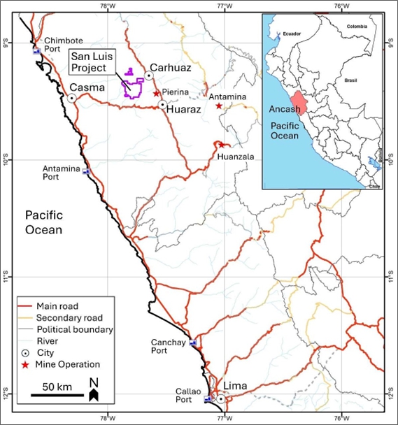
| Figure 5-1 | Map showing the road network and accessibility of the San Luis Project |
| Technical Report on the San Luis Property | 26 |
| 5.2 | Climate |
The climate is generally quite arid from May to December, with daily temperatures ranging from 22°C to -10°C. The ‘rainy’ season, from January to April, has more moderate temperatures but also heavy rains, dense fog, hail and snow at higher elevations. Maximum monthly precipitations range from 206 mm in February to 2.5 mm in July (Pincus and McCrea, 2006).
| 5.3 | Local Resources |
The project site is rural and isolated. The nearest population centres are Tambra (located on the western limit of the property) and Pueblo Viejo (situated in the northeast portion of the project concessions). Both villages are located in the Shupluy District, Yungay Province, Ancash Department, and each has approximately 500 inhabitants. The larger population centres near the project are Casma, Carhuaz, and Huaraz. Each of these population centres have labour and services required to support the development of a mining project.
| 5.4 | Infrastructure |
Reliant has two camp installations at the San Luis Property – the original exploration camp established at an elevation of 3,705 metres above sea level (masl), and a construction start-up camp established in 2010 at an elevation of ±4,000 masl.
The exploration camp is comfortably equipped for 18 staff, 8 technical and 5 security personnel, and includes a canteen, a large core store, core cutting and office facilities (Figure 5-2).
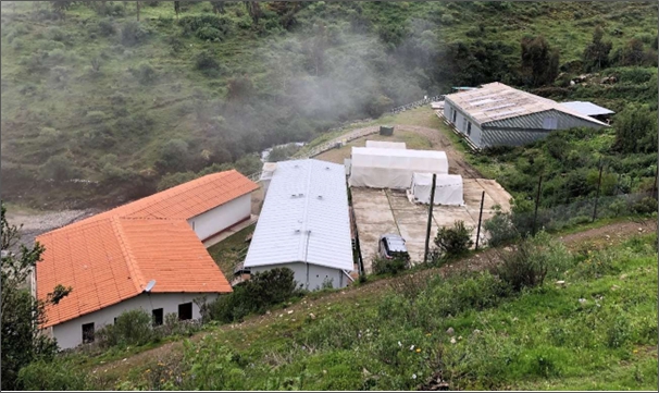
| Figure 5-2 | San Luis exploration camp at 3,705 masl, with the canteen to the left, accomodation in the centre, and core shed to the right |
| Technical Report on the San Luis Property | 27 |
The construction camp (Figure 5-3) is not yet being used due to suspension of project development activities. It is built on three levels, and has accommodation and office capacity for 32 staff, 60 technicians, and there is additional space for workers that has not yet been built. The upper level includes a 2,000-gallon fuelling facility, and stores and maintenance space. There is a large generator on site which has never been put to work.
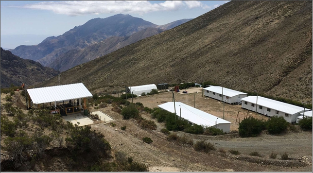
| Figure 5-3 | Partly installed San Luis construction camp at 4,000 masl |
Power supply to the exploration camp comprises the use of two diesel generators which currently require maintenance.
The power company Distriluz and its local subsidiary Hidrandina have reportedly (BISA, 2010) applied for expansion projects that would allow San Luis to draw power from the grid, however, the QP is informed that the utility is unable to offer any assurance that these projects will proceed.
| 5.5 | Physiography |
The physiography of the region is mountainous with high elevation rolling hills and valleys surrounding higher craggy snow-capped mountains, typical of the western front of the Peruvian Andes. Relief is high with local elevations varying from 3,700 m (12,140 ft) at the project campsite to 4,850 m (15,912 ft) masl at the peak of Cerro Huilcahuaín.
The local vegetation varies with elevation. Below 4,000 m elevation there are small deciduous trees and bushes and various grasses while above this elevation the mountain slopes are sparse covered with Stipa Ichu (grass) and various small bushes, typical of the ‘Puna’.
Domesticated llamas graze the local grasses, and there are several varieties of rodents, and resident and migratory birds within the property.
| Technical Report on the San Luis Property | 28 |
| 5.6 | Water Resources |
Existing water resources in the project area include several freshwater lagoons and some seasonal surface water. Some of the lagoons are currently used to supply water to the small adjacent communities of Tambra and Pueblo Viejo. This water is, however, subject to seasonal variations and anecdotal evidence indicates that water supplies could disappear during the dry season.
Specifically, four small lagoons are located within the project’s area of indirect influence (Figure 5-4). These include the Pacsococha and Orcuncocha lagoons, which drain to the Tocash gorge, as well as the Cotacocha and Yahuarcocha lagoons which drain their waters to the Huanchuy gorge. These lagoons could be used as a potential source of water supply if necessary.
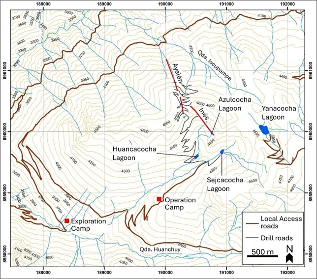
| Figure 5-4 | Map showing the camp locations and four lagoons within the project area |
Several other lagoons are located within the project’s area of direct influence, and these include Yanacocha, Azulcocha Baja, Huancacocha and Sejcacocha lagoons. Yanacocha lagoon drains towards the Iscupampa gorge while the others drain towards the Huanchuy gorge. The Sejcacocha lagoon was being planned (BISA, 2010) to be used as a location for the tailings storage facility.
The Tocash and Huanchuy gorges join with the Iscupampa gorge to the west of the project to form the Quellaycancha River. This in turn is a tributary of the Yaután River and the Yaután River sub-basin represents approximately 4% of the hydrographic basin of the Casma River.
With installation of a water diversion sump in Quebrada Huanchuy, it has been determined (BISA, 2010) that an adequate water supply can be maintained year-round to support the needs of the project and adjacent communities.
| Technical Report on the San Luis Property | 29 |
| 6 | HISTORY |
According to Konkin (2007) and Pincus and McCrea (2006), there is no evidence of any modern exploration work or previous land tenure in the vicinity of the San Luis vein system in the west-central portion of the property. Six kilometres to the southeast, there are historical test pits, short adits and evidence of past polymetallic ‘high grading’ operations within what is referred to as the BP zone that were reportedly active in the 1980s and possibly earlier.
It appears that artisanal miners extracted manto-hosted pyrrhotite-sphalerite-galena mineralization at what is referred to as the BP zone, and silver veins were mined at the Esperanza mine to the west of Ayelén. There is also evidence of trials at Yanacoto and San Simon where they appear to have transported hand-cobbed mineralization away for milling. Nevertheless, it appears that the Ayelén and the other precious metal-bearing vein structures are 2005 grassroot discoveries by Reliant, as there was no reported historical mineral resources or documented production from this part of the San Luis Property.
The Ayelén and Inés vein gold discoveries were made by Reliant, a wholly owned subsidiary of ESC in 2005, which was followed by a 55% earn-in joint venture agreement with SSR Mining made later that year which led to the trenching and drilling exploration of the two main veins found during 2006–2008. SSR Mining’s percentage ownership was increased during 2009 to fund the Feasibility Study announced towards the end of 2010. The residual 30% of the Reliant property was then acquired by SSR Mining for the sum of US$18 million plus the return of 6.5 million shares and a 1% NSR.
An Environmental Impact Statement was approved in 2012 for construction of the project, although there has been no progress with this up to the date of this report. Instead, wider exploration activities were started with the exploration of nearby porphyry-related mineralization potential, and during 2014 the Bonita vein was discovered approximately 7.5 km to the south-southeast of the Ayelén discovery. It appears that SSR Mining was focusing Reliant to look for more gold potential in order to extend the life of mine indicated from the 2010 Feasibility Study.
SSR Mining then entered into joint venture or other agreement with Hochschild Mining in 2015, but this was soon terminated in 2016. SSR Mining then had to apply for an extension to the Environmental Impact Statement in order to keep the construction approval valid.
After 2016, the San Luis Project appears to have gone quiet again, and any further progress was further delayed during the 2019–2020 pandemic. In the period 2021–2023, there was a resumption of concession-wide field mapping, and it can be seen from a 2023 company presentation document that they were actively maintaining community relations, whilst exploring for more mineral resources. In the meantime, the decision to go ahead with construction remains on hold.
On May 23, 2024, HSC announced that it had acquired Reliant’s San Luis Gold-silver Project (the “San Luis Property”) from SSR Mining, pursuant to a share purchase agreement dated November 29, 2023.
| Technical Report on the San Luis Property | 30 |
| 7 | GEOLOGICAL SETTING AND MINERALIZATION |
Peru has a long and complicated geological history dominated by the Andean Cordillera that extends both north and south along the western margins of South America.
Most of the stratigraphy, structure, magmatism, volcanism and mineralization in Peru is spatially and genetically related to the tectonic evolution of the Andean Cordillera which is situated along a major convergent subduction zone where the oceanic crust, the Nazca Plate, slips beneath the overriding South American continental plate. The Andean Cordillera has a metamorphic rock basement of Proterozoic age on which Hercynian Paleozoic sedimentary rocks accumulated and were in turn deformed by plutonism and volcanism to Upper Paleozoic time. Beginning in the Late Triassic time, following Atlantic Ocean rifting, two periods of subduction along the western margins of South America has resulted in the formation of the present Andes; the Mariana-type subduction from the Late Triassic to Late Cretaceous and Andean-style subduction from the Late Cretaceous to the present (Benavides- Caceres, 1999).
The Western Andean Cordillera, or Cordillera Negra, is famous for its world-class base and precious- metal deposits; many of which have been intermittently mined since Inca times. Most of the metal deposits in Peru are spatially and genetically associated with metal-rich hydrothermal fluids generated along magmatic belts that were emplaced along convergent plate tectonic lineaments. Furthermore, many of these primary base metal deposits have undergone significant secondary enrichment over the last 30 Ma as a result of periodic continental uplift and weathering, followed by volcanic cover preservation (Quang et al., 2005).
Radiometric studies by Petersen (1999) correlated the igneous host rocks and attendant hydrothermal alteration for some of the largest and richest porphyry copper deposits in the world along the Western Andean Cordillera from 6° to 32° south latitude, including the Chalcobamba–Tintaya iron-gold-copper skarn and porphyry belt (30–35 Ma) in the main magmatic arc, southward through the Santa Lucia district (25–30 Ma) and into Chile. The Andahuaylas–Yauri Porphyry Copper Belt, a well-known 300 km long porphyry copper belt related to middle Eocene to early Oligocene calc-alkaline plutonism, is situated along the northeast edge of the Western Andean Cordillera.
| 7.1 | Regional Geology |
The San Luis Property is situated regionally within the Cordillera Negra geomorphological terrain of the Peruvian Andes. A few kilometres east of the property is the northwest-trending Huaylas Valley, drained by the Rio Santa, and further east is the Cordillera Blanca which includes Cerro Huascaran, the second highest peak in South America at 6,768 masl.
| Technical Report on the San Luis Property | 31 |
| 7.1.1 | Cordillera Negra Mountain Range |
The geology of the Cordillera Negra is dominated by andesitic volcanic and volcaniclastic rocks of middle Tertiary age (Figure 7-1). Tectonically deformed sedimentary rocks of Cretaceous age and granitoid rocks of the Coastal Batholith underlie the mainly intermediate volcanic rocks. The volcanic rocks of the Cordillera Negra in the project area belong to the Calipuy Formation of Eocene age (i.e. approximately 55–38 Ma.). This formation comprises lavas and synvolcanic dykes and sills, fine to coarse-grained pyroclastics and volcaniclastic units. The volcanics range in composition from andesites to dacites, with rhyolites being relatively minor volumetrically. A regional unconformity separates the Tertiary volcanic sequence from the underlying Cretaceous lithologies which predominantly consist of granodiorite along the western flank of the cordillera and marine sedimentary units along its eastern flank.
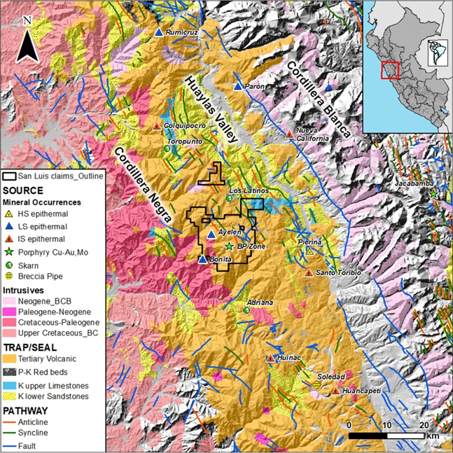
| Figure 7-1 | Map showing the regional geological setting and the north-northwest trend of faulting, and the Tertiary Volcanic Belt, carrying high-sulphidation epithermal (Pierina), low-sulphidation epithermal (San Luis) deposits and skarns |
| Technical Report on the San Luis Property | 32 |
| 7.1.2 | Huaylas Valley |
The succession of Cretaceous sedimentary rocks that probably form the core of the Cordillera Negra is well exposed along the eastern and western slopes of the Huaylas Valley that separates the Cordillera Negra to the west and the Cordillera Blanca to the east. The oldest of these rocks belong to the Upper Jurassic Chicama Formation of interbedded mudstone and sandstone cropping out northeast of the town of Yungay.
The Lower Cretaceous Chimu Formation conformably overlies the Chicama Formation. It includes a sequence of quartzite, sandstone and lesser shale. These siliciclastic rocks outcrop near the town of Pariacoto, situated southwest of the property, as well as in the Huaylas Valley to the east.
The Lower Cretaceous Santa Formation of limestone and calcareous clays, the Carhuaz Formation comprised of sandstone and quartzite with interbedded mudstone and the Farrat Formation of fine- grained quartzite with interbeds of red mudstone disconformably overlie the Upper Cretaceous Chicama Formation.
These formations are in turn overlain by a Cretaceous sequence of calcareous rocks belonging to the Pariahuanca, Chulec and Pariatambo formations that dominantly crop out along the eastern flank of the Cordillera Negra.
The Miocene to Pliocene-age Yungay Formation of dacitic tuff and ignimbrites fill the paleo-valley bottoms along the Santa River, east of the property, and recent fluvial and glacial unconsolidated sediments overlie all the above formations.
| 7.1.3 | Cordillera Blanca Mountain Range |
The western portion of the Cordillera Blanca is marked by a spectacularly rugged, permanently snow- capped mountain range formed by the rapid uplift and erosion of a granodioritic to tonalitic batholith that is exposed for more than 200 km in a northwest-southeast direction and 12–15 km west to east. Middle to Upper Cretaceous shale and limestone formations dominate the fold-and-thrust belt that parallels the eastern flank of this cordillera.
| 7.1.4 | Structure |
This region has undergone four main stages of structural deformation. The first stage resulted in the uplift of the Andean belt and the regression of Cretaceous seas from the region. This was followed by a major orogeny beginning in the late Palaeocene that produced the pronounced northwest-southeast trending folds and thrust faults that affected the early Jurassic to Cretaceous sedimentary rocks of the region. The third stage is characterized by regional block faulting which vertically deformed all the stratigraphy, including the basement rocks. The final stage of regional tectonism resulted in Pliocene to Pleistocene uplift of the Andean belt with the eastern Cordillera Blanca mountain range being uplifted more than the western Cordillera Negra.
| 7.2 | Property Geology |
The San Luis Property is dominantly underlain by volcanic, volcanoclastic and sub-volcanic intrusive rocks of andesitic-dacitic to rhyolitic composition belonging to the Paleocene-age Calipuy Formation. The Lower Cretaceous Santa Formation of limestone and calcareous clays crops out locally as ‘windows’ within the younger overlying volcanic rocks. Elsewhere, intrusions of the Coastal batholith are exposed in the southwestern portion of the property (Figure 7-2).
| Technical Report on the San Luis Property | 33 |
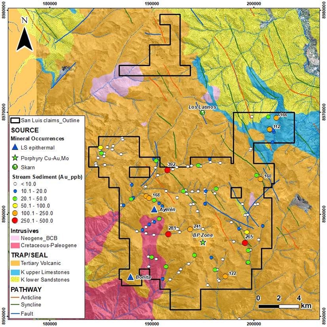
| Figure 7-2 | Reliant’s regional geology and target generation map based on stream sediment sampling |
| 7.2.1 | Lithology |
The property is predominantly underlain by Eocene-age volcanic and volcanoclastic rocks belonging to the Calipuy Formation (Figure 7-3). The basal section of the volcanic sequence is dominated by thick lavas and probably synvolcanic sills of massive, commonly medium-grained to feldspar porphyritic andesite (Figure 7-4). This sequence of volcanics is estimated to have a thickness greater than 300 m.
| Technical Report on the San Luis Property | 34 |
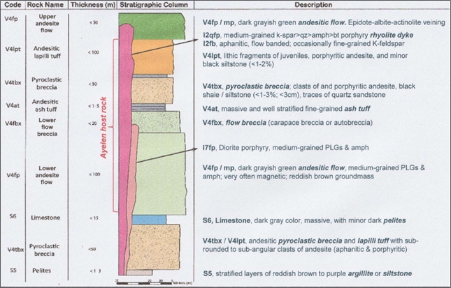
| Figure 7-3 | Stratigraphic column for the Ayelén District (developed by Reliant) |
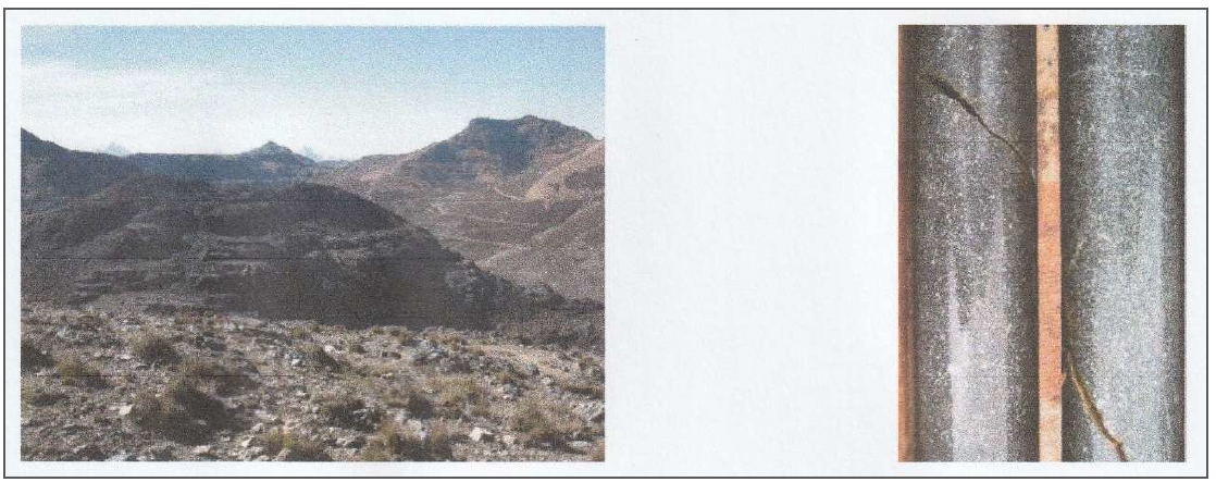
| Figure 7-4 | Left – Dark grey, sub-horizontal andesitic flows (photo centre) near Inés vein structure. Right – Drill core of fine to medium-grained, feldspar-phyric andesite that constitutes portions of andesitic flow unit (coded V4, V4m (massive), V4mg (medium-grained) and V4fp (feldspar-porphyritic in drill logs). |
| Technical Report on the San Luis Property | 35 |
In the vicinity of the San Luis vein system and probably elsewhere on the property, the basal andesite flows are conformably overlain by a unit of andesitic tuff breccia of probably volcanoclastic origin. It contains boulder to pebble-sized clasts of a variety of andesite and possibly dacite lithologies and distinguished by the presence of pebble shards of black shale (Figure 7-5). This unit is of variable thickness, and where intersected by drilling it is in the order of 10–30 m thick.
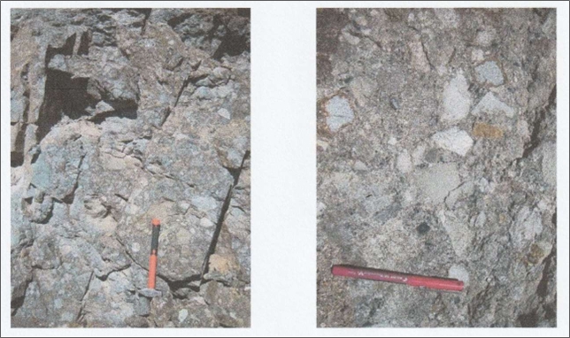
| Figure 7-5 | Heterolithic andesitic tuff-breccia with majority of poorly sorted andesitic volcanic clasts (left); Close-up of tuff breccia with black shale clasts (coded V4tbx in drill logs) (right) |
A sequence of andesitic pyroclastic flows and possible air-fall ash and crystal-lithic tuffs directly overlie the coarse clastic unit (Figure 7-6). The pyroclastic flows are rich with lapilli-sized andesite clasts including dark green, chloritized pumice fragments that are commonly flattened to form fiamme (Figure 7-6). These pyroclastics are exposed at elevations greater than 4,300 masl comprising beds of 200 m thickness or more. They are the youngest extrusive volcanic rocks identified on the property to date.
| Technical Report on the San Luis Property | 36 |
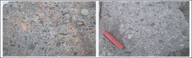
| Figure 7-6 | Left – Outcrop of pyroclastic flow rock with lapilli-sized, andesite and dacite volcanic clasts, and dark green, chloritized andesite pumice fragments partially compressed to form fiamme (coded V4pmt or V4lpt when pumice clasts are minor or absent). Right – Outcrop of coarse-grained andesitic crystal-lithic tuff (coded V4xlt in drillhole logs) exposed immediately west of the Ayelén vein structure. |
Felsic volcanics have yet to be identified on the property, but rhyodacitic to rhyolitic dykes and sills intrude the andesitic lava and pyroclastic sequences. These dykes have also been emplaced along the same fault and shear structures hosting both auriferous and barren quartz-calcite veins. The dykes are aphanitic to weakly quartz-porphyritic and locally have flow banding, especially near their contacts.
Accompanying the Ayelén vein structure, there are two varieties of dykes, namely: feldspar (± quartz eye) porphyry (I2fp, qfp) and flow-banded spherulitic or amygdaloidal dyke (I2fb, sphl, amy). Both varieties appear to be of calc-alkaline composition. These dykes are described by Konkin (2007) as follows, from oldest to youngest:
| ● | Very fine-grained, finely laminated, flow-banded dyke (I2fb) contains rare spherulitic (I2sphl) or amygdaloidal (I2amy) textures that may be confused with porphyritic textures. This dyke is often well fractured, oxidized and altered. |
| ● | Feldspar (+ quartz) porphyry dyke is pale beige to speckled green-grey in colour with very minor alteration and oxidation. Its porphyritic texture is generally obvious except near its wall-rock contacts. Late-stage veining is minimal, less than in the flow-banded dyke or other country rocks. |
At the separate BP zone, andesite lavas are intercalated with at least three units of fine-grained sedimentary rock including calcareous mudstone and impure limestone. These inter-beds are 0.5 m to 2.5 m thick and have been traced a few hundred metres along strike. The same calcareous units have been locally metasomatized to form calc-silicate exoskarn rock and pyrrhotite-sphalerite-actinolite ‘manto’ deposits.
The Lower Cretaceous Carhuaz Formation of sandstone and fine-grained quartzite with interbedded mudstone crops out as small ‘windows’ through the overlying Calipuy Formation. These isolated ‘windows’ appear to be spatially related to antiformal fold axis cores and local normal block faulting in the central and northern portions of the property. However, insufficient fieldwork has been carried out to determine their nature or stratigraphic position in the regional geologic setting.
Granodioritic intrusions of the Cretaceous to Paleocene-age Coastal batholith crop out within the western mineral concessions of the property, near the village of Tambra.
Colluvial deposits are omnipresent on the slopes of the volcanic hills and mountains, while fluvial-glacial deposits of variable thicknesses occur in the stream valleys.
| Technical Report on the San Luis Property | 37 |
| 7.2.2 | Structure |
Geological mapping by INGEMMET (1995) has identified several northwest-trending anticlinal and synclinal fold axes north and east of the San Luis vein system and BP zone, respectively. Regional compressional movement that has produced this folding appears to have also resulted in conjugate strike-slip faulting mapped within the northeast and northern portions of the property. Block-bounding faults appear to dominantly strike north-northwest and east-west, and dip from moderately to steeply eastward to sub-vertically. Relative displacements are in the order of tens of metres to perhaps more than 100 m.
The north-northwest trending fault structures are important for their mineral exploration potential since they appear to control and host most of the known precious metal-bearing vein structures, such as the Ayelén vein which has been traced on surface for more than 720 m. Other vein structures of the San Luis vein system occupy similarly oriented fault structures striking northwest to north-northwest with variable dips. The faults hosting the Ayelén and Inés veins define the western and eastern limits respectively of a horst block that is at least 125 m wide. Here, massive andesite lava rock of the horst is structurally juxtaposed against younger pyroclastic rocks and tuff-breccias to the west and east respectively. The northwest and north-northwest faults, especially those vein-hosting structures, have been repetitively active since the majority of volcanism ceased, prior to the main epithermal veining events. However, faulting also occurred during and after vein emplacement resulting in the well-developed vein breccia textures, open tensional sites for later rhyodacitic dyking, and later brecciation and displacement of both the dykes and vein structures.
Pincus and McCrea (2006) documented a sequence of structural events that may have controlled the emplacement and subsequent deformation of the known vein structures. These structural events were interpreted as follows:
| ● | “D1 deformation: Regional deformation resulting in east-west sinistral strike slip movement. Well defined structural lineaments can be seen on Aster and Quick Bird images north and south of the identified veins. Resulting regional extensional features probably resulted in the initial development of the NW-SE trending veins. It is assumed this period of deformation was caused by the initial emplacement of the Coastal Batholith. Across the valley, towards the north from Ayelén, folds can be seen with strong axial planar cleavage, probably produced during the emplacement of the batholith. |
| ● | S1 vein development: Open fractures developed during D1 were filled during multiple pulses of hydrothermal activity as reflected by well-developed colloform banding. |
| ● | M1 mineralization: Varying degrees of Au/Ag mineralization probably were associated with the multiple pulses of silicification during S1 development as noted by iron oxides (FeOx) and fine grey sulphides in the colloform bands. |
D2 deformation; Following the initial emplacement of the Coastal Batholith there was probably a period of tectonic relaxation resulting in readjustment of the stress regime and local horst and graben development accompanied by normal oblique/dip slip faulting. A well-developed horst can be seen that is bounded by the Ayelén and Inés veins. Strong brecciation of the S1 veins occurred during this period.
| Technical Report on the San Luis Property | 38 |
| ● | S2 vein development: Silicification of the brecciated S1 veins and probable development of ladder structures (noted in the Sheyla vein) occurred during or in the waning stages of D2.” |
The Calipuy volcanic units have variable dips across the property but generally they are sub-horizontal to very shallow dipping. In the vicinity of the Ayelén and Inés veins zone, the country rocks commonly dip -10° to -20° west-southwest, whilst within the BP zone the lavas and sedimentary inter-bedding dip shallowly westward.
A regional unconformity separates the Eocene-age volcanic strata from the underlying Cretaceous-age intrusive and sedimentary rocks. Within the property boundaries, this unconformity has only been observed along the gravel track that leads from the exploration field camp to the Ayelén–Inés vein system. At an elevation of about 4,200 masl, medium-grained granodiorite forms the basement to the Tertiary volcanic pile. It is suspected by the project geologists that a basal conglomerate may occur with this unconformity: one rich in granodiorite clasts with detritus derived from Lower Cretaceous sedimentary rocks was found in the region.
| 7.2.3 | Alteration |
Regional green-schist metamorphic facies affect the country rocks ubiquitously throughout the property and can be misinterpreted as distal hydrothermal alteration. In the volcanic and volcanoclastic rocks of the Palaeocene Calipuy Formation, mafic minerals have been chloritized, plagioclase phenocrysts have been saussuritized to varying degrees, and quartz, calcite and magnetite alteration products are common, especially in well sheared and fractured zones.
On the other hand, Konkin (2007) has described the hydrothermal alteration in the vicinity of the Ayelén vein as follows:
“Although much of the (Ayelén vein) system appears to be near-vertical, the strongest alteration occurs in the hanging wall or western portion of the vein and immediately adjacent to the rhyolitic dykes. The footwall geology is composed primarily of feldspar porphyry flows (V4fp) and its’ minor associated members (V4m, V4fbx, V4mg). These rocks exhibit weak argillic alteration at the immediate vein and dyke contacts but the alteration rapidly grades to a moderate propylitic alteration just a few centimetres from the structures. Weak to moderate propylitic alteration is commonly observed throughout this entire footwall unit. Very little iron oxidation is associated with the footwall zone.
The strongest alteration occurs throughout the upper half of the hanging wall sequence within the pyroclastic units along shears that host veins and dykes. Strong argillic alteration is observed over 1-2 meter widths within these shear zones. The majority of the pyroclastic upper volcanic sequences contain weak near-surface pervasive argillic alteration. This may be related to the chemical breakdown of the unit rather than the epithermal alteration. Otherwise the majority of the alteration is confined to weak-moderate propylitic alteration similar to that which occurs within the footwall.
Similar to the argillic alteration, strong to moderate limonitic fracture-controlled oxidation is commonly associated with and along the flow-banded rhyolite dyke and veins at the upper portion of the system. The oxide development decreases rapidly below 125-150 meters with only minor sporadic fracture controlled limonite. Due to the low volumetric presence of sulphides, the level of iron oxidation is considered to be low within the Ayelén vein.”
Geological mapping within the separate BP zone has identified several alteration facies typically associated with a shallow-buried calc-alkaline stock intruding volcanic and volcaniclastic country rocks. According to Ferraris (2007), the most intense hydrothermal alteration occurs in the immediate vicinity of hydrothermal breccia bodies, mantos, and dioritic intrusions and fault and shear structures. Silicification is widespread, as quartz fracture filling and veining; potassic alteration occurs peripheral to dioritic stocks and feldspar porphyry dykes; and argillic alteration, as montmorillonite and illite, occurs mainly in the volcanic country rocks with interbedded sedimentary beds.
| Technical Report on the San Luis Property | 39 |
Contact metasomatic alteration of the calcareous sedimentary units within the volcanic sequence has produced skarns (± grossularite) with manto mineralization, including pyrrhotite and pyrite with lesser sphalerite and chalcopyrite. Galena and molybdenite are rare. Iron oxide alteration (gossan) zones are widespread and affect all lithologies, especially the andesitic volcanics at higher elevations of the Huilcahuain mountain, and surrounding the feldspar porphyry intrusions at the Pucajirca summit (Ferraris, 2007).
| 7.3 | Mineralization |
Four main types of potentially economic mineralization have been identified on the property to date, including:
| ● | Gold and silver-bearing epithermal quartz veins comprising the “San Luis vein system” |
| ● | Zinc-rich sulphide replacement bodies, referred to as “mantos” |
| ● | Base metal-bearing sulphide mineralization hosted by brecciated and hydrothermally altered andesite and polylithic breccias of undetermined origin |
| ● | A copper-molybdenum porphyry system within the BP zone. |
| 7.3.1 | San Luis Vein System |
Recent exploration has identified a number of mineralized quartz veins in different areas of the property concessions, but the most intense and advanced exploration has been undertaken on the San Luis vein system, especially the Ayelén and Inés vein structures. The San Luis vein system includes, from west to east, five principal veins known as: ‘Ayelén’, ‘Inés’, ‘Paula’ and ‘Paula Split’, ‘Regina’ and ‘Sheyla’ (Figure 7-7). These en-echelon vein structures strike approximately west-northwest to northwest and are spaced at 400–600 m intervals within an east-west trend within the property. The combined strike length is almost 5 km, although less than one-quarter of this strike length has been explored to date.
The Ayelén and Inés vein structures were identified from surface trenching as carrying anomalous gold and silver values, and these became the focus of most of the 2006 and 2007 drilling programs since they were indicated to host the highest precious metal grades. Elsewhere, 21 other drillholes have tested some of the other quartz vein structures and stockwork-type mineralization identified to date.
The San Luis vein structures have continuous strike lengths over hundreds of metres and down-dip extents, based on drilling intercepts, exceeding 200 m. Vein thicknesses vary considerably due to local faulting, shearing and dyking; however, they range in true width from 50 cm to more than 10 m but commonly average 1.5 m to 3.5 m. The vein structures are controlled and hosted by normal faults that are sub-vertical to moderately to steeply inclined to the northeast.
| Technical Report on the San Luis Property | 40 |
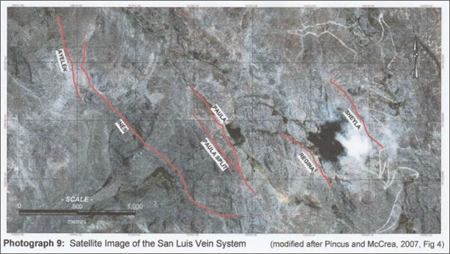
| Figure 7-7 | Satellite image of the San Luis vein system (modified after Pincus and McCrea, 2007) |
At the Ayelén and Regina veins, rhyodacitic to rhyolitic dykes of 2–12 m thick have been emplaced along the controlling fault structures for the veining. Along the Ayelén vein structure, two or more felsic dykes have intruded both the fault and vein. It appears from drilling results that the dykes are dominantly post-mineral relative to the main auriferous vein mineralization but locally they do host volumetrically minor gold and silver-bearing mineralization that may be either late-stage primary or of secondary origin.
| 7.3.2 | Vein Mineralogy |
Textural features of the various San Luis veins are consistent with veins of low sulphidation epithermal origin, showing alternate colloform banding and laminae of white, grey, pale green quartz, chalcedony, carbonates and possible minor adularia (Figure 7-8 left) hosting grey bands of very fine-grained pyrite with electrum, acanthite and base metal sulphides (Figure 7-8 right). Lattice-type crystal growths can be locally observed where coarse calcite blades have been replaced by silica with chalcedonic quartz filling matrix between the silica pseudomorphs. In addition to these typical epithermal vein textures, the San Luis veins are composed in part of massive white quartz, repetitively brecciated vein quartz and tectonic breccia clasts composed of silicified, angular to partially-milled andesite clasts mixed with vein fragments that have been cemented with drusy and colloform quartz and calcite. The well mineralized Ayelén vein generally tends to display more complex vein textures than the other major veins, especially those hosting little or no significant precious metal mineralization such as the Regina and Sheyla veins (Burk, 2007).
| Technical Report on the San Luis Property | 41 |
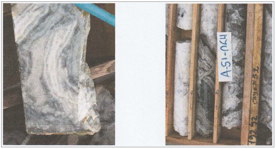
| Figure 7-8 | Left – Drill core samples showing typical multiple brecciation and epithermal vein textures of the Ayelén vein. Thin laminations and colloform banding of quartz, chalcedony, sericite, calcite and minor adularia. Right – Drill core (DDH A-SL-064) hosting grey bands of very fine-grained pyrite with electrum, acanthite and base metal sulphides. |
Fifteen drill core samples of the wall-rocks were petrographically examined by consulting petrographers C. Leitch and J. Shannon to determine the mineralogy of the hydrothermal alteration, especially that of the Ayelén vein. According to Burk (2007), vein rock samples examined by Leitch contained small fragments of volcanic wall rocks, mainly medium-grained andesite, showing pervasive alteration to secondary growths of quartz-sericite-calcite/dolomite-pyrite. Similar alteration mineralogy also forms proximal haloes to the vein structures extending a few tens of centimetres from vein margins into the wall-rock andesitic volcanics. The sericite-rich ‘inner’ alteration facie grades outward from the veins into ‘outer’ facies of chlorite-sericite-calcite ± minor disseminated pyrite which generally extends a few metres away from the veins and locally up to 20 m. Sericite in the outer alteration facies tends to be replaced by albite further away from the veins.
Hydrothermal alteration is also developed in the felsic dykes that are spatially associated with some of the veins, typically consisting of moderate to strong replacement of plagioclase, alkali feldspar and minor biotite by sericite-calcite with minor disseminated, fine-grained pyrite. Within the zone of supergene oxidation, which extends little more than 15–20 m below surface along the Ayelén vein, the relatively minor amounts of pyrite in the mineralized veins (less than 5% by volume) have been converted into limonite-goethite fracture fillings and coatings. Metallic minerals, except for pyrite, only occur in trace amounts and are generally very fine-grained. Minute grains of native gold, native silver, electrum, acanthite, sphalerite, chalcopyrite, galena and possible tetrahedrite have been observed microscopically (Leitch, 2007). Visible gold (or electrum) was observed by the author in outcrops of the Ayelén vein near Trench 10. These precious metal and sulphide minerals are seen to generally occur in paragenetically late quartz + sericite ± calcite veinlets and breccias-fillings.
| Technical Report on the San Luis Property | 42 |
The following text provides more detailed descriptions of the principal vein structures comprising the San Luis vein system.
Ayelén Vein
The Ayelén vein is the most extensively explored and better mineralized of the known vein structures (Figure 7-9). Trenching and diamond drilling have traced this structure along a strike length of over 720 m with down-dip extensions of 100–327 m, striking of 340–345°. Surface mapping results indicate the vein structure dips -75° to -85° west-southwest, but drilling results show the controlling fault structure(s), subsurface individual vein segments and post-mineral dykes dip vertically to -80° west-southwest. True thicknesses of individual vein segments vary from tens of centimetres to over 10 m, averaging 1.5 m to
3.0 m wide.
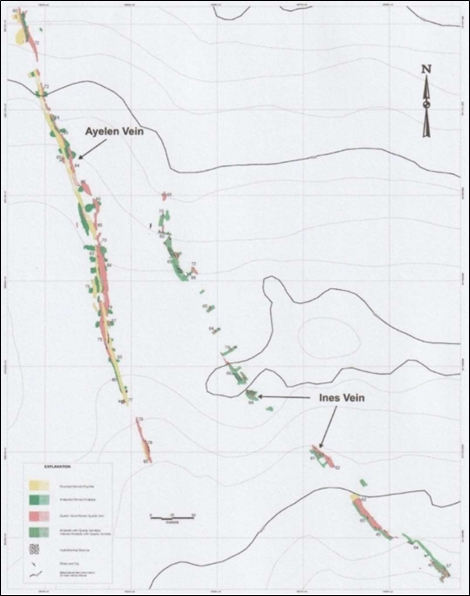
| Figure 7-9 | Geology of the Ayelén and Inés vein structures (modified from Pincus and McCrea, 200C) |
| Technical Report on the San Luis Property | 43 |
Thirty-two surface trenches were excavated along the surface trace of the Ayelén vein and 108 diamond drillholes, totalling 19,195.15 m, have tested its down-dip extensions during the 2006 and 2007 exploration programs. The results of this work show that the vein structure has been displaced by faulting and shearing repeatedly during the emplacement of the veining, mineralization and later dyking. The mineralizing events appear to have extended from the initial vein emplacement to after the emplacement of the two varieties of felsic dykes since, although generally barren, the dykes do host very local fracture filling precious and base metal mineralization. Repetitive faulting and shearing have produced multiple lenticular vein bodies or segments that dominantly occur on the footwall or east-northeast side of the dykes in the southern portion of the structure but occur between and bound the dykes on both sides towards the north-northwest end. Thus, the collective Ayelén vein structure has been subdivided into hangingwall and footwall sections based upon their relative position with respect to the post-mineral dykes.
Vein composition, texture and mineralogy are characteristically epithermal, low sulphidation vein type. Quartz, chalcedony, calcite and minor adularia are the main gangue minerals, occurring with typical banding, layering and brecciation. Electrum, acanthite and other silver sulphosalts are the main economic minerals accompanied by trace amounts of sulphide minerals including: pyrite, chalcopyrite, galena and sphalerite.
According to Pincus and McCrea (2006), the weighted average grade from 2006 surface trench sampling along a 350 m strike length is 51.7 g/t Au and 1,078 g/t Ag. The mineral resources of the Ayelén and Inés vein structures is the subject of this review of the Reliant ‘Mineral Resource Estimate’ previously carried out (Blanchflower, 2009).
At the southern end of the vein structure, at local grid line 1575 m north, lenses of brecciated quartz veining occur between three rhyolitic dykes that vary in thickness from 3 m to 7 m and dip 80° southeast. On grid line 1675 m north, 100 m to the north-northwest, three drillholes have intersected several rhyolitic dykes (or faulted dyke segments) with a number of 50–150 cm thick quartz veins between them and on the footwall side of the dyking. This set of veins is well developed at a vertical depth of about 75 m and weakens near surface. A 4–5 m thick brecciated quartz vein was encountered on the west or hangingwall side of the felsic dykes that extends to a depth of at least 150 m below surface. Higher grade precious metal mineralization is prevalent on the eastern or footwall side of veins from surface to a vertical depth of about 200 m.
On grid line 1750 m north, the Ayelén vein structure is in part formed by a quartz-healed, apparently milled tectonic breccia that follows the eastern branch or splay of a bifurcating normal fault structure. The previously mentioned felsic dyke is interpreted to have been intruded into the western splay of the fault zone. Based on drilling results, the two splayed fault structures merge together at about 100 m below surface, beneath which there is a lens of brecciated quartz-calcite vein rock and hydrothermally altered wall-rock breccia. This well-mineralized lens of veining and brecciation is up to 6 m thick and extends 70 m down-dip on the western side of the felsic dyke.
Around grid line 1825 m north, the Ayelén vein structure simplifies and trends approximately 5–7° or more to the north. This inflection in the strike of the vein structure is interpreted to be the loci of an intersecting northwest-trending fault. At this location, there is a single vein segment in the upper 100 m that trends along the eastern (footwall) side of the rhyolitic dyke. This vein of variably textured epithermal quartz pinches down within about 90 m below surface and continues downward as a narrow shear infilling along the margins and contained within the rhyolitic dyke. There are also two other weakly mineralized, narrow quartz vein segments at a depth of 200 m below surface, one within the dyke and one on the footwall side. These lenticular vein segments within the otherwise barren dyke may be either faulted slices or evidence of post-dyking mineralization during late-stage tectonism. The highest grade gold-silver mineralization occurs within 100 m of surface.
| Technical Report on the San Luis Property | 44 |
Further to the north, on grid line 1900 m north, the Ayelén vein structure occurs as a single, wedge-shaped lens of quartz veining that is up to 9 m thick at surface and narrows down to less than 1 m at 120 m below surface before pinching out entirely. The vein is situated on the eastern side of a 3–7 m thick, steeply westward dipping rhyolitic dyke. At a vertical depth of 100 m, the felsic dyke merges with the main sub-vertical dyke body that continues to depth. Between a vertical depth of 50 m and 100 m, there is a narrow mineralized quartz vein between the two branches of the rhyolitic dyke structure. At a vertical depth of 190 m, veining along the Ayelén vein structure reappears in the form of two relatively thin brecciated veins, but these are only weakly mineralized.
The Ayelén vein structure continues north-northwest on the eastern side of the rhyolitic dyke. On grid line 2000 m north, there are two well-mineralized vein segments to a vertical depth of 100 m below surface, varying in true thickness from 1 m to more than 3 m each. Beneath this level, the veins pinch out against the rhyolitic dyke margin. At 200 m below surface, thin breccia veins or lenses of hydrothermal breccia exist along both margins of the rhyolitic dyke, but these do not carry any significant gold or silver values.
From grid lines 2000 m to 2100 m north, the Ayelén vein appears like sheeted veins of quartz breccia on both sides of the rhyolitic dyke. The highest gold and silver values are hosted in 1–10 m thick veins within 30–100 m of surface.
Close to the northern limits of the well-mineralized section of the Ayelén vein structure, on grid line 2175 m north, there are two separate rhyolite dykes separated by 3–15 m. The 3–4 m thick eastern dyke appears to be the rhyolite body along which most of the Ayelén veining follows while the 8–11 m thick western dyke is quartz porphyritic. Brecciated quartz veins, 50–150 cm thick, occur on both sides of and in between the two dykes. This segment of the Ayelén vein structure is weakly mineralized.
Inés Vein
The Inés vein structure is situated approximately 110 m east of the Ayelén vein structure, trends north-northwest at 320–340° and dips -50° to -75° north-northwest (Figure 7-9). Drilling and geo-modelling results indicate that the primary and easterly-dipping normal fault structure controlling this vein may intersect the Ayelén vein structure in the vicinity of surface trench number 16 at UTM. 190455 m east by 8961000 m north with parasitic structures trending northward. The main brittle-ductile structure appears to be a listric fault, since the vein dips about -75° eastwardly near surface then progressively more gently at -60° to -45° as it is traced downwards. The Inés vein crops out as series of discontinuous resistant ridges for more than 2,200 m along strike with apparent widths of 2.0 m to 7.5 m, but assay results from the outcrop and surface trench samples show that only a relatively short section of the Inés vein is significantly mineralized with gold and silver. This mineralized section is situated where it is closest to the Ayelén vein.
Based on drilling and mapping results, the Inés vein has the appearance of a brittle-ductile fault zone, approximately 1–5 m wide, hosting anastomosing veinlets of quartz and tectonic breccias healed by quartz and coarse-grained calcite. Sizeable epithermal quartz structures such as that forming the Ayelén vein are not commonly developed along the Inés vein structure, except where it is well mineralized (Burk, 2007).
Prospecting, geological mapping, surface trenching and 28 diamond drillholes, totalling 3,157.8 m, has tested the Inés vein with most of the work being undertaken along its 475 m long northwest portion. The drillholes usually ranged between 75 m and 250 m in length and were inclined westward. Drilling results indicate that only a short section of Inés vein, perhaps 100 m in strike length, is host to potentially economic gold-silver mineralization.
| Technical Report on the San Luis Property | 45 |
Along grid line 1825 m north, the Inés vein structure is a continuous, arcuate structure, 1–3 m thick, that can be traced to a vertical depth of at least 150 m. Within 50 m of surface, the structure consists of banded quartz hosting significant gold and silver mineralization. With depth the banded quartz appears replaced by weakly to unmineralized massive to highly fractured quartz-calcite vein gangue. At a depth of 100 m or more, hydrothermal breccia rock dominates the structure where fragments of andesitic flow rock are encrusted or supported by quartz and calcite (Burk, 2007).
Paula and Paula Split Veins
The Paula and Paula Split vein structures are situated approximately 650 m east of the Inés vein. These two veins coalesce at 191900 m east by 8960100 m north. They crop out as discontinuous resistant quartz vein exposures along a strike length of 1,100 m. The main Paula vein structure strikes north- northwest at 320–330°, and dips at -50° to -75° northeastwardly. The structure appears to pinch and swell with an apparent maximum thickness of 9.5 m (Pincus and McCrea, 2006). The parasitic Paula Split vein structure branches to the north-northwest and parallels the Paula vein for a few hundred metres. It may join the main vein at depth.
The Paula vein structure has been tested to depths of 50–255 m from surface with 10 diamond drillholes, totalling 1,759 m, spread out along a 350 m long section of its known strike length. Each of the drillholes intersected the anticipated structure but encountered zones of discontinuous thin quartz veins and veinlet stockworks containing traces of disseminated fine-grained pyrite and in some cases minor aggregates of chalcopyrite. None of the intercepts yielded precious metal assays of economic significance.
When drilling the Paula vein structure, drillholes P-SL-065, P-SL-112 and P-SL-122 intersected a buried vein, approximately 1–2 m thick, on the eastern side of the Paula vein that hosts geochemically significant values of gold and silver. This ‘Cristina’ vein strikes at 345° and dips 60° eastwardly and represents a potential drilling target for future exploration (Burk, 2007).
Regina Vein
The Regina vein structure crops out approximately 2 km east of the Ayelén vein or 600 m east of the Paula vein. It has a rhyolitic dyke along its western margin, similar in size and appearance to those along the Ayelén vein structure. At outcrop, the Regina vein structure is characterized by its breccia texture with abundant angular fragments of sericite and calcite-altered andesite encrusted with drusy and colloform banded quartz which attains a maximum thickness of 4.2 m. Rock sampling in 2006 traced this vein structure for 500 m along a northwesterly trend. According to Pincus and McCrea (2006), “Eight grab samples returned low gold and silver values (up to 4 ppm Ag) but were strongly anomalous in arsenic and less so in antimony.”
In 2007, five diamond drillholes tested the Regina vein structure beneath its strongest surface expression. Four drillholes (R-SL-50, R-SL-51, R-SL-52, and R-SL-54) were completed from two drill sites situated about 75 m apart. These drillholes tested the vein structure at vertical depths of between 50 m and 100 m. Only slightly anomalous gold values were encountered in drillhole R-SL-54. A fifth, deeper drillhole was directed in between the two-hole fans and intersected the Regina vein structure 250 m below surface. It failed to intersect any significant precious metal values (Burk, 2007).
| Technical Report on the San Luis Property | 46 |
Sheyla Vein
The Sheyla vein structure is situated 2.5 km east of the Ayelén vein, or 400 m east of the Regina vein. Prospecting and diamond drilling has traced this quartz breccia vein for 700 m along a northwesterly trend with a maximum apparent thickness of 3 m. Four drillholes (S-SL-44, S-SL-46, S-SL-47, and S-SL-48), totalling 595 m, from two sites 240 m apart, intersected the vein structure between 65 m and 125 m below surface. Only traces of fine-grained pyrite and acicular tourmaline were encountered in the vein intercepts with no significant gold and silver values (Burk, 2007).
Puca-Puca Quartz Stockwork
A limonitic quartz stockwork zone outcrops along the access road that passes between the Regina and Paula veins. It was deemed worthy of evaluation and in 2007 two drillholes tested this 20 m wide quartz veinlet structure. The first hole was planned to intersect the targeted zone at a depth of 250 m, but it failed to encounter any significant veining or brecciation. A shorter hole was then drilled to cut the stockwork 75 m below surface, but it too failed to intersect anything of interest (Burk, 2007).
| 7.3.3 | Zinc-Copper-Lead-Silver (± Gold) Manto Mineralization of the BP Zone |
The BP zone is situated approximately 6 km southeast of the San Luis vein system (Figure 7-10). It covers approximately 12 km2 where the Calipuy Formation is prominently stained by limonite, goethite and hematite derived from the pyritized andesitic country rocks, which is readily visible in the IKONOS satellite imagery (Figure 7-10). At the centre of this zone, within a glacial cirque on the northern flank of Cerro Huillcahuain, there are a number of small, abandoned trenches and short adits collectively known as the ‘Patococha’ mineral showings. These minor workings were reportedly active in the 1980s and possibly earlier where the local miners ‘high-graded’ sub-horizontal tabular ‘manto’ bodies of fairly coarse-grained pyrrhotite-sphalerite mineralization and transported the hand-cobbed mineralization away for milling.
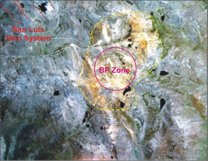
| Figure 7-10 | Satellite image of the San Luis vein and BP zones (after Ferraris, 2007) |
| Technical Report on the San Luis Property | 47 |
The Patococha ‘manto’ or skarn occurrences are 50–250 cm thick. They have been traced along strike for several tens of metres, and dip -20° south to southwestwardly (Figure 7-11). According to Ferraris (2007), these mantos are commonly associated with quartz stockwork veining within the underlying andesitic volcaniclastics, and usually terminated by strike-slip faulting trending northwest and steeply dipping (Figure 7-11 left). They are hosted within a sequence of andesite lava flows and are interpreted by the project geologists to be metasomatic deposits where interbedded, fine-grained, sedimentary units have been partially replaced by hydrothermal intergrowths of pyrrhotite, sphalerite, galena, actinolite-tremolite and chlorite.
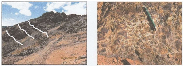
| Figure 7-11 | Patacocha manto occurrence (highlighted as white lines), after Ferraris, 2007 (left); Quartz-calcite stockwork hosted by andesitic rocks beneath manto occurrences (right) |
Besides pyrrhotite, sphalerite is the most common sulphide mineral found in the mantos with reported zinc contents ranging up to 12% (Burk, 2007). Galena may be nearly absent or occur in significant amounts. It is reported that some samples returned values of up to 6% lead (Burk, 2007). Chalcopyrite and possibly other sulphides, such tetrahedrite-tennantite, are locally present in trace to minor amounts. Samples with relatively high lead contents have correspondingly higher silver and gold concentrations (Burk, 2007).
Lithogeochemical sampling of the exposed manto occurrences has been undertaken and a combined magnetics and induced polarization geophysical survey of the BP zone has been carried out. A number of the east-west and north-south oriented survey lines passed over the sulphide replacement bodies. No diamond drilling within the zone has yet been specifically targeted to test the economic potential of the manto mineralization.
| 7.3.4 | Hydrothermal Breccia-Hosted Copper-Lead-Zinc-Silver Mineralization |
Hydrothermally brecciated, intensely altered and mineralized andesite crops out a few hundred metres north of the Patoccocha manto deposits, central to the much larger gossan area defining the BP zone. Bedrock exposures occur around a small pond and bog locally known as Laguna Patococha, suggesting that the breccia body has an elliptical shape with surface dimensions in the order of 400 m by 200 m (Figure 7-12). Significant pyrite, chalcopyrite, sphalerite and minor galena mineralization occurs within a brecciated matrix.
| Technical Report on the San Luis Property | 48 |
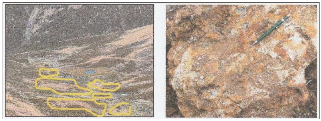
| Figure 7-12 | Aerial view of Patacocha hydrothermal vein outcrops (yellow lines) (left); Outcrop of hydrothermal breccia (right) |
During 2007, Reliant carried out geological mapping, at a scale of 1:2,000, lithogeochemical sampling survey (75 samples), conducted a combined magnetics and induced polarization geophysical survey, and completed four diamond drillholes, totalling 1,067 m, within the BP zone.
According to Burk (2007) and based upon surface outcrop and drill core observations, medium-grained andesitic flow rocks around Laguna Patoccocha have been strongly fractured and locally brecciated, apparently as a result of hydrostatic over pressuring related to a well-evolved hydrothermal event. In addition to brittle deformation, the hydrothermal fluids caused relatively widespread and locally intense mineral alteration of the andesitic country rocks. Macroscopic examinations indicate that original plagioclase-pyroxene composition of the intermediate volcanics was initially affected by pervasive potassium metasomatism resulting in fine-grained intergrowths of brown biotite and secondary alkali feldspar (albite ± orthoclase) with finely disseminated and fracture filling pyrite mineralization (Figure 7-13).
The phyllically altered volcanic rocks were strongly fractured and altered by a third stage of hydrothermal fluids that replaced sericite with kaolinite and minor calcite and quartz. Open spaces within well brecciated rocks were infilled by relatively coarse-grained pyrite and lesser amounts of chalcopyrite, sphalerite and galena. Calcite and drusy quartz also occur as crystal growths in open fractures and breccia vugs.
The three superimposed hydrothermal alteration facies at Laguna Patoccocha are interpreted to indicate a hydrothermal system with an initial potassic signature with each subsequent facie being progressive at a lower temperature. The key secondary phases that were stable during each of the three stages are represented by biotite, sericite and kaolinite, respectively. It is possible that this “collapsing” hydrothermal system had evolved from a magma source that could also be the source of an unidentified buried porphyry intrusion beneath the altered andesitic volcanics (Burk, 2007).
| Technical Report on the San Luis Property | 49 |
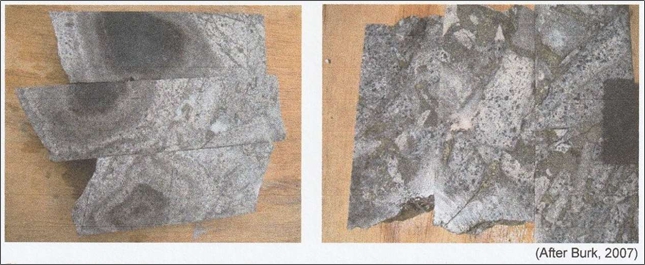
| Figure 7-13 | Representative drill core samples from drillhole BP-SL-131, Patoccocha breccia, BP zone |
| Notes to the left image: Original medium-grained andesite is altered to the dark brownish-grey rock rich with secondary biotite, representing the first alteration facie. The pale grey rock is phyllically altered to a sericite-quartz-pyrite assemblage with fracture filling pyrite and coarse-grained white quartz and calcite. | |
| Notes to the right image: Pale grey phyllically alter andesite has secondary intergrowths of sericite-quartz-pyrite. Lighter grey alteration is marked by kaolinite replacing sericite. Dark specks may consist of late-stage biotite or quartz-tourmaline clusters. Well-developed hydrothermal breccia texture with coarse-grained pyrite and chalcopyrite mineralization with quartz-calcite gangue occupies the matrix between the breccia fragments. |
| 7.3.5 | Copper-Molybdenum Porphyry-Type Mineralization |
At BP zone, in the central-east part of the San Luis Project, the dominated andesitic volcanic rocks are widely altered to pyrite- and pyrrhotite-bearing, biotite hornfels by a concealed intrusive centre. Within the southern part of the alteration zone, the andesitic rocks and a shallowly inclined rhyolite sill host a porphyry-type veinlet stockwork, with surface dimensions of at least 800 m by 600 m (Sillitoe, 2011). Additional stockwork veining is reportedly also present at surface some 1 km farther north.
According to Sillitoe (2011), the stockwork is formed by D-type quartz-pyrite-(pyrrhotite) veinlets, with sericitic selvages up to 1 cm wide, which attain intensities of 20–40 per linear metre. Earlier B-type veinlets are much less abundant, ranging from <1 to a maximum of 3 per linear metre. The B-veinlets generally contain molybdenite, pyrite and, locally, minor chalcopyrite, and many of the wider (>0.5 cm) veinlets display the characteristic confinement of molybdenite grains to the veinlet margins. The B-veinlets lack alteration selvages and, in places in the andesitic host rocks, contain flakes of biotite (and minor epidote), implying that they accompanied potassic alteration: a conclusion further supported by the presence of clots and veinlets of biotite throughout the stockworked andesitic rocks. In contrast, the rhyolite sill is everywhere sericitic altered, a feature believed to be attributable to its more felsic, iron-poor initial composition.
The stockworked rocks are only weakly mineralized, averaging only several hundred parts per million copper, much of it contributed by disseminated grains of chalcopyrite. Molybdenum values are erratically distributed but attain several hundred ppm where the B-veinlets are most closely spaced.
Two dacite porphyry dykes, containing plagioclase, biotite and subordinate quartz phenocrysts, were observed in drill core from holes BP-SL-148 and 151. The porphyry is chloritized and only weakly veined compared to the immediate host rocks. Sillitoe (2011) interpreted that these dykes are late inter-mineral in timing and they emanated from a concealed porphyry centre beneath the observed BP stockwork zone, but after completion of most of the alteration and mineralization.
| Technical Report on the San Luis Property | 50 |
Sillitoe (2011) stated that such B-type and D-type veinlets are generated exclusively in porphyry copper systems, implying that a progenitor stock must be present at depth. That early-mineral porphyritic stock was not identified neither on surface mapping nor in the drillholes made to date.
| 7.3.6 | Mineralogical/Petrographic Studies |
Two petrographic analyses were carried out on samples from the Ayelén vein. One was performed by Dr Craig Leitch and the other was prepared by BISA.
Dr Leitch analysed nine samples of sawn core to determine:
| ● | Mode of occurrence of gold and silver |
| ● | Locking of metal values with quartz or adularia |
| ● | Secondary enrichment of gold or silver. |
Dr Leitch reports that “the samples mostly consist of epithermal-looking quartz-carbonate-sericite vein material with textures ranging from breccia to crustiform, colloform banded, comb- or cockade-textured, to locally vuggy or very fine-grained (“chalcedonic”), with only minor sulfides. Clasts in breccia veins are mainly intensely altered, to quartz-sericite-carbonate-local chlorite, rutile, and only rarely retain vestiges of former (felsic to intermediate, volcanic to hypabyssal?) origin. Carbonate likely includes calcite and dolomite (plus local Fe-calcite and ankerite?). Sulfides are mainly fine-grained pyrite, commonly partly to wholly replaced by limonite, but in several samples trace to significant base-metal sulfides, including chalcopyrite, sphalerite (ranging from colourless or pale yellow, low Fe, to almost opaque, due to minute oriented inclusions of chalcopyrite), galena (rarely intergrown with acanthite or tetrahedrite?), and rare possible marcasite (?). In 5 (possibly 6) of the 7 samples from drillholes SL609, 610, 613 and 702, rare small (<15 to 100 micron) particles of yellow-brown, partly tarnished (?) possibly native Au or electrum occur, mostly associated with either relatively late carbonate, sericite, quartz veinlets or fractures; they only locally appear to be locked within carbonate or pyrite (or limonite after pyrite), not quartz or adularia. In the two samples from SL01 and 02, traces of highly tarnished, possibly native Ag/electrum (?) as ragged particles or aggregates up to 200 microns across are also associated with late quartz, sericite veinlets or open fractures. No evidence of enrichment of Au or Ag was noted in the sections”.
BISA carried out mineralogical analyses on 11 samples collected from diamond drill core and surface trenches in the Ayelén vein area.
BISA reports that “vein material mostly consists of quartz, calcite, sericite and illite. Quartz is present in different forms such as hyaline quartz, gray and chalcedonic with banded, crustiform and brecciated textures.
Microscopic evaluation indicates three common groups of minerals:
| ● | Native minerals (gold, silver, electrum) |
| ● | Sulphides (pyrite, chalcopyrite, sphalerite, galena, argentite, pyrrhotite, marcasite) |
| ● | Oxides (hematite, limonite, goethite). |
BISA reports that gold is mainly present as electrum and in smaller amount as free fine-grain gold (0.002 mm to 0.04 mm). Native gold appears to contain some silver giving it a pale colour and, in some cases, causing it to be confused with electrum. Silver, in addition to electrum, is present as argentite and argento-jarosite associated to pyrite and grey quartz. The amount of silver in electrum varies and often it is difficult to identify if silver is native silver or electrum.
| Technical Report on the San Luis Property | 51 |
Pyrite is the most abundant sulphide. It is often associated with occurrences of native gold, native silver and electrum as indicated in Figure 7-14. Chalcopyrite, galena and sphalerite are present in trace amounts. Their amounts tend to increase with depth. Hematite, goethite and limonites are observed in the upper part of the mineralized system.
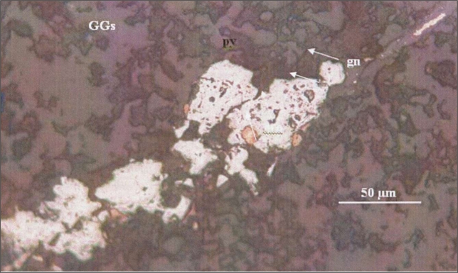
| Figure 7-14 | Native gold grain filling up porosities in the pyrite (py); the biggest grain measures 0.02 mm |
| Note: Pyrite is present filling up a fracture in the gangue (GGs). In addition to gold, there are some grains of galena (gn) filling porosities in the pyrite. |
| Technical Report on the San Luis Property | 52 |
| 8 | DEPOSIT TYPES |
Four distinctly different mineral deposit types have been identified within the property. The most extensively explored are the epithermal, low sulphidation, gold and silver-bearing, quartz-calcite veins of the San Luis vein system, while the others, hydrothermal breccia-hosted base metal, manto-hosted occurrences and copper-molybdenum porphyry type stockwork, appear related to a buried intrusion, possibly of calc-alkaline composition, central to the BP zone.
The vein-hosted gold-silver occurrences, and the hydrothermal breccia and manto-hosted base metal mineralization are relatively close, and appear to share common regional structural controls.
| 8.1 | Deposit Classification |
| 8.1.1 | Epithermal Low-Sulphidation Precious Metal Vein Mineralization |
The gold and silver-bearing veins of the San Luis vein system have many characteristics typical of ‘epigenetic or epithermal, low sulphidation, precious metal vein deposits’. According to Simmons et al. (2005), “Epithermal deposits comprise epigenetic ores that are generally hosted by coeval or older volcanic rocks. Most commonly, mineralized bodies occur in veins with steep dips that were formed through dilation and extension. Some are hosted by major faults but more commonly they are hosted by minor faults with smaller displacements (< 10 m)” (Pincus and McCrea, 2006).
The following description of low sulphidation precious-metal vein-hosted mineralization was documented by Pincus and McCrea (2006) after Simmons et al. (2005):
“Low sulphidation mineralization consists of a gangue mineral assemblage containing quartz-calcite-adularia-illite. Gold typically occurs as electrum and silver occurs as electrum, acanthite and other silver sulphosalts. Epithermal deposits are characterized by a variety of textures including crustiform banding, often with interlayers of quartz and sulphide minerals. Bands are often interrupted indicating repeated pulses of mineralization. Lattice textures in which calcite crystals have been replaced by quartz and brecciation are also common characteristics.
Interpretations of the epithermal model indicate that ore-bearing fluids typically travel along structural pathways at high temperatures with sufficient hydrostatic pressure to prevent boiling. When the pressure drops suddenly through faulting or rupture, boiling occurs and the fluids quickly deposit their mineral load in available open spaces. Deposition of minerals, particularly quartz will typically occur in these open spaces with bands growing from either wall inward. Open spaces are eventually sealed by this growth until ruptured once again by underlying fluid pressure or new faulting and the process begins over again. This repeated rupturing results in the interrupted banded texture typical of epithermal veins.
As described above, structural features, particularly faulting and fracturing, are a key element in controlling the location of ore deposition. Ore ‘shoots’ will typically occur in dilational zones, which in turn result from a variety of local stresses. Often these stresses are repeated along the length of a vein structure resulting in multiple ore-shoots.
The total precious metal content of epithermal systems can often be significant. Some deposits have been characterized as ‘bonanza’, that is greater than 1 million ounces of gold at a grade of greater than 30 grams per tonne. Significant deposits that have been classified as low-sulphidation epithermal deposits include: Fresnillo in Mexico (800,000 ounces Au and 516 million ounces Ag), The Comstock Lode in California (7.6 million ounces Au and 176 million ounces Ag), El Peñon in Chile (3.8 million ounces Au and 63 million ounces Ag) and Midas in Nevada (2.5 million ounces Au and 30 million ounces Ag) (Hedenquist et.al., 2005).”
| Technical Report on the San Luis Property | 53 |
The currently understood geological model is summarized in Figure 8-1.
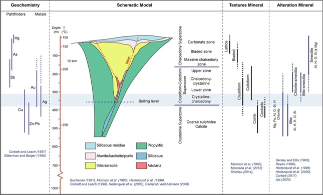
| Figure 8-1 | The epithermal model (Hedenquist et al., 1996, 2000, 2005 and others) |
| Source: Reliant, 2024 |
| 8.1.2 | Copper-Molybdenum Porphyry and Related Base Metal Mineralization (BP Zone) |
The BP zone has many features indicative of a central, buried intrusion responsible for locally intense brittle fracturing, hydrothermal breccia bodies, multiple alteration facies, peripheral ‘manto’ or skarn occurrences, and base and precious metal mineralogy with an intrusion-related, possibly calc-alkaline, porphyry-style signature. These deposits typically occur in association with the emplacement of high-level stocks during extensional tectonism related to regional strike-slip faulting at convergent plate boundaries or back-arc spreading following continent margin accretion. Any type of country rock may be mineralized but commonly the high-level stocks and related dykes intrude their coeval and cogenetic volcanic piles (Panteleyev, 1995).
Calc-alkaline porphyry deposits typically have stockworks of quartz veinlets, quartz veins, closely spaced fractures and breccias containing pyrite and chalcopyrite with lesser molybdenite, bornite and magnetite occurring in large zones of mineralization in or adjoining porphyritic intrusions and related breccia bodies. Disseminated sulphide minerals are present, generally in subordinate amounts. The mineralization is commonly spatially, temporally and genetically associated with hydrothermal alteration of the host rock intrusions and wall-rock (Panteleyev, 1995). Intrusions range from coarse-grained phaneritic to porphyritic stocks, batholiths and dyke swarms; rarely pegmatitic. Compositions range from calc-alkaline quartz diorite to granodiorite and quartz monzonite. Commonly there are multiple emplacements of successive intrusive phases and a wide variety of breccias (Panteleyev, 1995).
| Technical Report on the San Luis Property | 54 |
| 8.1.3 | Sillitoe Opinion |
Following a three-day visit to the San Luis Property, Richard Sillitoe (2011) provided Reliant with the following observations:
| ● | “The Ayelén bonanza-grade gold-silver ore shoot is considered as an erosional remnant of the shallow parts of a classic low-sulphidation epithermal vein. Nearby veins appear to have been more deeply eroded, leading to loss of any ore shoots. However, further geological reconnaissance designed to search for previously undetected ore-shoot remnants would be justified. |
| ● | At the BP Zone, a well-developed stockwork of porphyry-type veinlets, some containing molybdenite, defines the lateral limits of a concealed porphyry copper centre. Two observed porphyry dykes within this zone may be late-stage offshoots of the porphyry intrusion that must be present in the core of the system. A second concealed porphyry centre may also exist farther north in the BP Zone. |
| ● | The zinc-rich mineralization present in hydrothermal breccias, replacement mantos and the Huinchos veins is considered to represent distal manifestations of the BP Zone porphyry centre, much of it generated relatively late in the evolution of the system. None of these mineralization styles is considered worthy of further attention. |
| ● | The low-sulphidation epithermal Ayelén and nearby veins are not genetically related to the BP Zone, but are products of a much earlier mineralization event. The temporal relations of the low-sulphidation veins and BP Zone with respect to minor rhyolite intrusions provide the basis for this metallogenically important conclusion. |
| ● | Following further geological definition of the outcropping stockwork zone, scout drilling is recommended in search of the concealed porphyry stock. Although the size, grade and depth of the inferred stock cannot be reliably predicted, drilling needs to be sufficiently deep to confidently intersect the early, best-mineralized phase of the stock, which is considered to require holes to at least 700 m depth. It is suspected that the porphyry copper mineralization will prove to be molybdenum rich.” |
Sillitoe’s report included the following conceptual diagram (Figure 8-2) in relation to the BP zone.
| Technical Report on the San Luis Property | 55 |
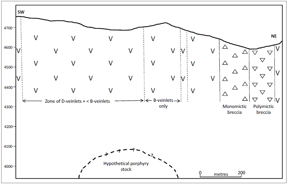
| Figure 8-2 | Schematic geological section of inferred BP zone porphyry copper centre |
According to Cox and Singer (1988), typical global calc-alkaline porphyry copper-molybdenum (± gold) deposits contain median values of 500 million tonnes with 0.41% Cu, 0.016% Mo, 1.22 g/t Au and 1.22 g/t Ag. Examples of this deposit type include: Brenda, Huckleberry and Schaft Creek (British Columbia, Canada); Casino (Yukon, Canada); Inspiration, Morenci, Ray, Sierrita-Esperanza, Twin Buttes, Kalamazoo and Santa Rita (Arizona, USA); Bingham (Utah, USA); El Salvador (Chile); and Bajo de la Alumbrera (Argentina).
| Technical Report on the San Luis Property | 56 |
| 9 | EXPLORATION |
Most of the exploration work has been focused on a 400–500 m section of the Ayelén vein structure and 100–150 m of the Inés vein structure where the highest gold and silver grades have been found to occur. These two vein structures have been tested with 136 diamond drillholes drilled in 2007–2008, totalling 22,354 m, and over 70 shallow trenches (Appendix A refers) from which surface channel samples have been collected. Elsewhere, the other vein structures and the BP zone have been tested with 25 diamond drillholes during this period, totalling 4,673 m.
The following text documents the exploration work undertaken by Reliant during the latter half of 2006 and 2007, and briefly summarizes earlier exploration work. The 2005 and early 2006 exploration work and their results are well documented in the November 2006 Technical Report by W.J. Pincus and J.A. McCrea.
| 9.1 | Exploration Program (2005) |
The San Luis Property was first visited by ESC field personnel in June 2005. They discovered and sampled the Inés vein structure which returned values ranging from trace to 1.56 g/t Au and 0.8–100 g/t Ag. During a later property visit in July 2005, the Ayelén and Paula vein structures were discovered, prospected and channel sampled.
The channel samples from the Ayelén vein returned values ranging from 0.026 g/t to 173.8 g/t Au and 23 g/t to 2,504 g/t Ag (Pincus and McCrea, 2006). Prospecting work by ESC later in the year led to the discovery of the nearby Sheyla and Regina vein structures.
| 9.2 | Exploration Program (2006) |
| 9.2.1 | Geological Mapping |
Dr Eric P. Nelson was retained to carry out geological mapping and a detailed structural analysis of the area surrounding the San Luis vein system at a scale of 1:2,000.
| 9.2.2 | Rock Geochemical Sampling |
Systematic channel sampling of the Ayelén and Inés vein structures was initiated in January 2006 and completed by November 2006 after being delayed during the rainy season (Table 9-1). According to Pincus and McCrea (2006), 32 separate trenches were excavated along the trend of the Ayelén vein structure at 25 m intervals and 403 channel samples were collected along these trenches from the vein structure and wall-rock (Figure 9-1). True thicknesses of the samples were calculated using the vein dips at each sample site. These vein dip angles varied from -70° to -85° west-southwestwardly. The results of the channel sampling showed that the Ayelén vein structure hosted values ranging from trace to 134 g/t Au and 5.3–2,246 g/t Ag over true vein thicknesses of 0.98–7.14 m (Pincus and McCrea, 2006). Figure 9-2 shows the locations of channel samples and results along the central portion of the Ayelén vein structure.
| Technical Report on the San Luis Property | 57 |
Table 9-1 Summary of surface trenches by vein target area
| Area | No. of samples | Metres sampled |
| Ayelén | 34 | 508.21 |
| Inéz | 62 | 441.00 |
| Total > | 96 | 947.21 |
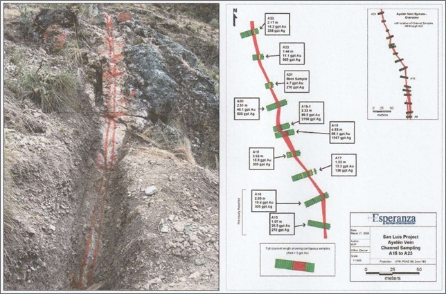
| Figure 9-1 | Hand-excavated trench with spray-painted locations of individual channel samples (after Pincus and McCrea, 2006) (left); Locations of 2006 channel samples on central portion of Ayelén vein structure (after Reliant, 2007) (right) |
Twenty-five trenches were excavated across the Inés vein structure at 25 m intervals and 90 channel samples were collected along these trenches from the vein structure and wall-rock. Vein structure dip angles varied from -65° to -75° northeast from which true thicknesses of the structure were calculated. Pincus and McCrea (2006) reported precious metal values for samples that graded greater than 1 g/t Au or representing longer true widths across the Inés vein structure. The reported results ranged from trace to 21.07 g/t Au and trace to 1,969 g/t Ag over true widths from 0.66 m to 3.43 m.
The results of this work identified the high gold and silver grades hosted by the Ayelén and Inés vein structures and showed that these veins have features commonly associated with typical low sulphidation epithermal vein systems. A detailed description of the trenching and rock geochemical sampling work is documented in the technical report by Pincus and McCrea (2006).
The results of the 2006 trenching program justified the start-up of diamond drilling in the same year (Item 10 refers).
| Technical Report on the San Luis Property | 58 |
| 9.3 | 2007 Exploration Program (2007) |
During the latter half of 2006, ESC and SSR Mining formed a joint venture and continued their exploration efforts through their joint venture subsidiary company, Reliant, under the terms of their joint venture agreement.
| 9.3.1 | Infrastructure Construction |
The existing field camp was renovated and expanded to accommodate anticipated field staff, diamond drillers and other contract personnel. In addition, the on-site core logging, sampling and storage facilities were renovated with sufficient capacity to process, handle and store all anticipated drill core.
Drill access roads had been constructed and drill pads excavated on all the known vein structures and within the BP zone for the 2006 and 2007 drilling programs. Access drill road construction included ditching and installation of culverts for surface water management and erosion control.
| 9.3.2 | Geological Mapping |
Reliant retained Mr Fernando Ferraris, CPG, to conduct a combined geological mapping and lithogeochemical sampling survey of the BP zone at a scale of 1:2,000. The results of his work were reported in the private Technical Report Pucajirca Hydrothermal Altered Zone, Ancash Department, Central Perú, dated July 2007.
| 9.3.3 | Silt Geochemical Sampling |
Exploandes Mining Exploration Consulting and Services of Lima, Peru was retained by Reliant to carry out a property-wide stream sediment (silt) geochemical sampling survey. This work was undertaken in two stages during the period of October 30 to December 30, 2006. A total of 187 stream sediment samples were collected and submitted for multi-element analysis including four standard, four blank and four field duplicate samples for quality assurance and quality control (QAQC) evaluation.
The results of the silt sampling survey showed a number of drainages within the property with geochemically anomalous precious- and/or base metal-in-silt values worthy of follow-up prospecting and further rock geochemical sampling.
| 9.3.4 | Rock Geochemical Sampling |
Most of the rock geochemical sampling work was undertaken within the BP zone during the mapping and sampling work by Fernando Ferraris (2007). A total of 105 rock samples were reportedly collected and analysed for 26 elements using inductively coupled plasma (ICP) techniques. The analytical results were then statistically analysed and plotted to show the distribution of gold, silver, base metals and a variety of trace elements within the BP zone.
The plotted geochemical results showed a spatial association of anomalous base metal-in-rock values within the manto and intrusive breccia-hosted mineralization. In addition, the distribution of anomalous copper, molybdenum, gold and silver-in rock values indicated that there may be a buried intrusion centrally located within the BP zone that may have been responsible for the widespread pyritization, together with an anomalous suite of elements commonly associated with an intrusion-related, porphyry-style occurrence.
| Technical Report on the San Luis Property | 59 |
| 9.3.5 | Geophysical Surveying |
Arce Geofisicos (“Arce”) of Lima, Peru was contracted to carry out a combined ground magnetics and induced polarization survey. This work included surveying 19,850 m in three east-west and five north- south profile lines across the central BP zone, and 3,500 m in five southwest-northeast profile lines across the northern extensions of the San Luis vein system area (Figure 9-2). The surveying work was completed during the period of August 23 to September 6, 2007 (Arce, 2007).
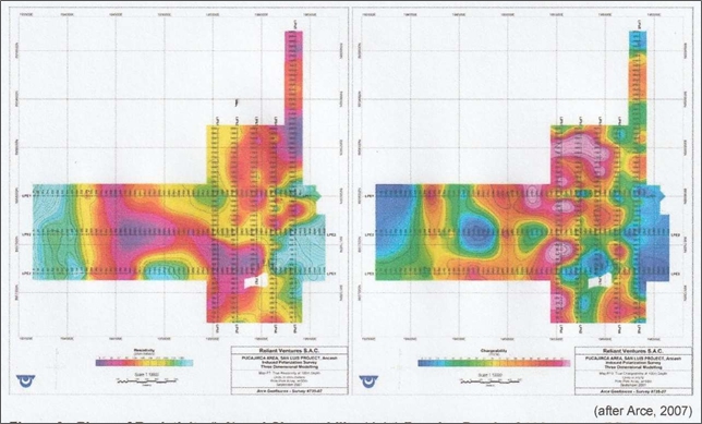
| Figure 9-2 | Plans of resistivity (left) and chargeability (right), depth of 100 m, BP zone |
According to the September 2007 geophysical report submitted by Arce, “The magnetic profiles were surveyed with readings every 10 meters, employing three Scintrex ENVI proton magnetometers, one for base station. The Induced Polarization profiles were surveyed with constant-spacing measurements taken at 50m intervals, employing the Pole-Pole (2-Array) electrode configuration, with a plotting point at mid-distance between the moving electrodes C1 and P1; seven successive “a” spacings of 50m, 100m, 150m, 200m, 250m, 300m and 350m were used, with apparent chargeability (Ma) and apparent resistivity (Ra) readings.
Line preparation and staking were topographically controlled with the GPS/OMNISTAR system, using a TDS Ranger 300X data processor and a Trimble AGGPS114 receiver. Expected errors are in the sub- metric range for the X-Y coordinates. GPS elevations have been corrected using bench mark SNL-18 located at Rocahuaran.”
| Technical Report on the San Luis Property | 60 |
The following geophysical results for the BP zone were summarized from the September 2007 geophysical report by Arce:
| ● | Total Field Magnetic Intensity – There are three obvious anomalies in the western portion of the survey area and one notable one where the north-south and east-west profiles cross. Two large magnetic bodies have been defined on profile lines LPE1 and LPE2 at distances of 800 m to 1,000 m. These is also a series of small dipole anomalies that could be reflecting many small and isolated magnetic bedrocks. |
| ● | Self-Potential – There are coincident self-potential and chargeability anomalies at LPN1/LPN2 (0 to 800) and at LPN2/LPN3(1550 to 1700). Other coincident anomalies occur on line LPN5 (2300 to 2600), line PPN4(150) and LPE2(600). |
| ● | Resistivity (20–280 m deep) – Resistivity readings range from less than 5 Ωm for strongly altered rocks to more than 3,000 Ωm for dense and silicified bodies. Highly resistive bodies occur near surface in the western, centre and eastern portions of the survey area. The central one disappears at some 100 m of depth while the others become less resistive with depth. |
| ● | Chargeability (20–280 m deep) – The strongest chargeability anomalies occur at shallow levels (up to 80mV/V on maps P11 (20 m) and P12 (50 m). There is an important chargeability anomaly centred at LPN1/LPN2(700 to 2000) and confirmed with LPE1/LPE2(1500 to 2200). |
| ● | 3D Modelling – Resistivity readings vary widely from <5 Ωm to >3,000 Ωm. Chargeability anomalies occur on all section lines indicating metallic sulphide mineralization or clay mineral alteration which can cause a similar response. |
| 9.3.6 | Diamond Drilling |
In 2007, Reliant continued drill testing of the Ayelén and Inés vein structures and proceeded to drill test the other known San Luis vein systems, including: Paula, Paula Split, Regina, Sheyla and Puca-Puca. Near the end of the field season four drillholes tested coincident geological, geophysical and geochemical anomalies in the vicinity of the mineralized hydrothermal breccia situated centrally within the BP zone. A total of 133 HQ-size diamond drillholes were completed during the 2007 field season totalling 23,261.05 m.
A more detailed summary of the 2006 and 2007 drilling programs follows in Item 10 of this report. Appendix I of the 2008 Technical Report (Blanchflower) contains a tabulation of all pertinent 2006 and 2007 drilling data and their mineralized intercepts made at that time.
| 9.4 | Summarized Results of 2006–2007 Exploration Drilling Programs |
The results of the 2006 and 2007 exploration work carried out by Reliant were summarized by Blanchflower (2008) as follows.
| ● | The property hosts three known types of mineralization: precious metal-bearing epithermal veins, manto-hosted base metal occurrences, and hydrothermal breccia-hosted base metal occurrences. |
| ● | The San Luis vein system, including the Ayelén, Inés, Paula, Paula Split, Regina, Sheyla and Puca- Puca veins, has been initially tested by prospecting, rock geochemical sampling, trenching and diamond drilling. The cumulative strike length of the combined vein structures is almost 5 km and less than one-quarter of this strike length has been explored. |
| ● | Property-wide stream sediment sampling results show a number of geochemical anomalies worthy of follow-up prospecting and rock geochemical sampling. |
| Technical Report on the San Luis Property | 61 |
| ● | Geological, lithogeochemical and geophysical results from recent work in the BP zone indicate that the recently discovered manto and hydrothermal breccia-hosted copper-lead-zinc-silver-gold mineralization may be related to a buried intrusion with the potential for porphyry-style mineralization. |
| ● | There is a 400–500 m section of the Ayelén vein and a 100–150 m section of the Inés vein, with significant economic potential worthy of continued work. |
| 9.5 | Engineering Drillhole and Site Investigation Work carried out in 2010 |
BISA (2010) reported that a “feasibility level” geotechnical and hydrogeological drilling program was completed for all project surface facilities being considered at that time. This comprised a geophysics survey, 11 drillholes totalling approximately 500 m, and 27 tests pits (and road cuts) were excavated and mapped in the accumulation of subsurface data across the project site and in areas that were restricted to drilling equipment.
| 9.6 | Exploration Program (2011–2012) |
After finalization of the 2007–2008 exploration activities attention had been turned to preparing an NI 43-101 compliant Mineral Resource estimate for the Ayelén and Inés veins (Lecher et al., 2009), which was then followed up by a project Feasibility Study (Kaye et al., 2010) focused on a standalone underground mining operation. Exploration activities do not appear to have been resumed until 2010.
Following a site visit to the San Luis Property by Sillitoe (2011), attention was drawn again to exploring the BP zone. This was followed up by a site visit by Drobek (May 2012) which recommended a preliminary drilling program of six drillholes totalling 4,300 m aimed at the potential porphyry target outlined by Sillitoe.
It appears that during the period 2011–2012, surface mapping was being carried out over and around the BP zone as evidenced from an Internal Report by Somers et al. (December 2012) which summarized the work that had been carried out. Figure 9-3 shows the prospective areas identified, and Figure 9-4 shows detail of the BP zone.
The BP zone is described as a gossanous area measuring 3.5 km by 2.5 km located at the northeast of the mapped area (Konkin, 2007). Ferrari (2007) first suggested the BP zone was part of a hidden porphyry copper system as indicated in this area by the occurrence of a large hydrothermal altered zone, stockwork of porphyry type veinlets, two porphyritic events, breccias, and mantos. Sillitoe (2011) later confirmed that a well-developed stockwork of porphyry-type veinlets probably defines the lateral limits of a concealed porphyry centre.
In 2007 and 2008, six drillholes, referred to as BP-SL132 to BP-SL133 and BP-SL148 to BP-SL151, were drilled directly under the anomalous copper and molybdenum surface samples collected from Ferrari (2007) (Konkin, 2007: Konkin et al., 2008; Figure 19). However, only weakly anomalous metal values of up to 0.12% Cu and 0.077% Mo were obtained over sporadic 2–9 m intervals throughout BP-SL148 and BP-SL151, while the other four holes returned no economically significant metal values (Konkin, 2007: Konkin et al., 2008). From 2008 to 2011, additional surface sampling and mapping allowed the definition of the stockwork boundaries and the anomalous molybdenum boundary (Figure 9-3). After the revision of Drobeck (2012) and Soler (2012), four proposed holes (600 m depth) were defined as priority to drill the copper-molybdenum porphyry target in 2013 (Figure 9-4). However, exploration was suspended, and these holes were never drilled.
| Technical Report on the San Luis Property | 62 |
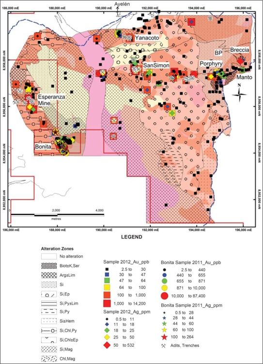
| Figure 9-3 | Geologic map showing gold and silver geochemical values from the 2011 Bonita target sampling and the 2012 BP zone sampling, location of the adits and trenches of the former Esperanza mine, Yanacota and San Simon prospects, and a noted breccia target |
Source: Somers et al. (2012)
| Technical Report on the San Luis Property | 63 |
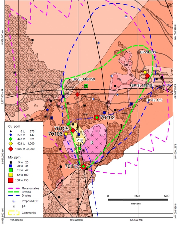
| Figure 9-4 | Geological map showing the south extension of the copper-molybdenum target in the BP zone with an off-centre unaltered granodiorite and feldspar-phyric intrusion, copper and molybdenum values from 2012 sampling, the limits of the molyndenum anomalies, and location of 2013 proposed drillholes |
| Technical Report on the San Luis Property | 64 |
With reference to the other areas explored during 2011–2012, Somers et al. (December 2012) summarized the following:
“Detailed mapping at a scale of 1:10,000 allowed a subdivision of the stratigraphy of the mapped area into formal formations and informal lithofacies and facies. The oldest formation is represented by the Cretaceous sediments, i.e., the quartzite and polymictic pebble to boulder conglomerate lithofacies, which occur as xenolithic fragments within the andesitic and dacitic intrusions respectively. The Paleocene Calipuy Formation is the most abundant formation in the mapped area, which consists of an andesitic polymictic volcaniclastic lithofacies, locally intercalated with a dacitic polymictic volcaniclastic lithofacies conformably overlain by a flow-banded feldspar- and biotite-phyric dacitic flow lithofacies. The Paleocene Calipuy Formation is intruded by synvolcanic feldspar- and mafic mineral-phyric andesitic dikes and sills, which were emplaced prior to the mineralization events. Two intrusive pulses of granodiorite and feldspar- and biotite-phyric dacite were emplaced before or during the epithermal mineralization event for the former, before or during the porphyry mineralization event for the latter, and after the epithermal and porphyry mineralization events for both. Rhyolitic dikes are interpreted as genetically related to the epithermal vein formation, but were emplaced prior to this mineralization as observed at the Ayelén vein system.”
Somers et al. (December 2012) go on to say that “during mapping program 2012, two new targets were discovered, the south extension of the Cu-Mo porphyry target at BP zone (Figure S-3 and Figure S-4 show location) and the precious and base metal epithermal quartz veins at San Simon and at Yanacoto (Figure S-3 shows location). Three other occurrences, discovered between 200C and 2011, are the oxidized Au- Ag-rich epithermal quartz veins at Bonita and the Ag-Pb-Zn±Cu-rich phreatomagmatic breccia and mantos at BP zone. Recommendations for each area are given below.
The south extension of the Cu-Mo porphyry target at BP zone will be tested in 2013 with the four proposed drillholes. It is recommended to drill to depth of more than C00 m as outlined by Sillitoe (2011). In addition to the recommendation of Sillitoe (2011), other Cu-Mo porphyry deposits were discovered in Peru with deep drilling beyond C00 m such as for the Haquira project in southern Peru owned by First Quantum Minerals Ltd. The Cu-Mo porphyry target and the gossanous area extend further to the south beyond the mapped area, and therefore, it is recommended that SSR acquires the accesses and exploration rights for the Chacchan Community to explore the entire Cu-Mo porphyry target.
For the San Simon target (C00 m by 400 m) and Yanacoto target (400 m by 500 m), detailed mapping (1:2,000) and sampling (spaced by 20 to 30 m maximum) of extensions of know veins, stockworks, rhyolitic dikes, and structures is recommended. This will define the location of the precious and base metal in preparation to drill 20 holes in 2014. The drill program objectives are: (1) drill underneath the precious and base metal anomalous zones to define the depth extent of the epithermal quartz vein mineralization and (2) drill one deep hole to test for stockwork zone commonly associated with precious and base metal epithermal veins at depth.
For the Bonita target (Figure S-3 shows location), it is recommended to do trenches of 200 m length every 30 m with retro excavator. Each trench will have approximately 10 channel samples that will average 2 to 3 m length. This will represent a total of approximately 300 samples for 20 trenches. The new trenches will better constrain the gold and silver anomalies of the epithermal quartz veins that will be used later to plan a drillhole program of 20 holes in 2014.”
It is concluded from a later presentation document that not all these trenches were carried out, although two diamond drillholes were drilled across one section of the Bonita mapped vein system (Figure 9-5 and Figure 9-6), and that further drilling was being planned. The two holes showed positive results, but also indicated (Figure 9-5) that the gold-silver grade might be declining with depth as had been previously found in relation to the Ayelén and Inés veins.
| Technical Report on the San Luis Property | 65 |
Trench sampling and drilling at Bonita appears to have ceased after 2012. Renewed interest in 2023 is evidenced from an application to MINEM dated 2/06/2023 to drill the holes previously planned together with surface trenching.
This application met with approval from MINEM dated 4/12/2023, of 37 surface trenches and 32 drilling platforms with reference to proposed exploration of the “Bonita” exploration target. Pursuant to applicable law, exploration activities under the Bonita DIA must commence on or before June 2, 2028. Failure to do so will result in the expiration of the Bonita DIA.
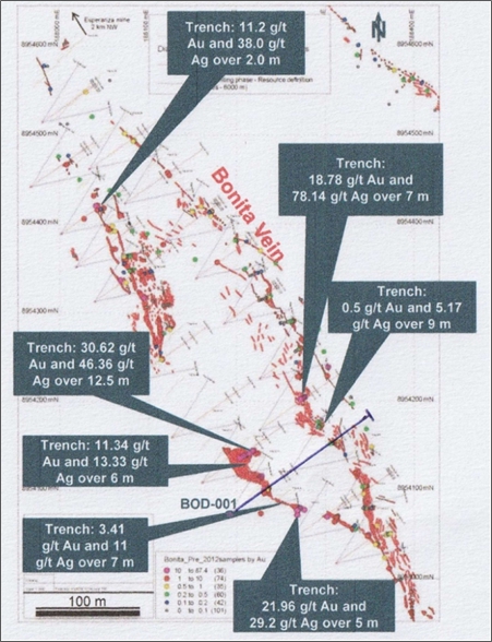
| Figure 9-5 | 2011–2012 Bonita trench sampling results and location of the first drillhole |
| Technical Report on the San Luis Property | 66 |
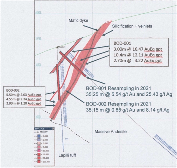
| Figure 9-6 | Two initial diamond drillholes drilled across the Bonita vein system |
| 9.7 | Exploration Restart (2021–2023) |
After an eight-year gap in activities, exploration on the San Luis Property was restarted in mid-2021 once access permission was granted by the Ecash and Cochabamba communities.
The main objective was to search for new gold-silver vein targets within the concessions surrounding the known Ayelén zone. This comprised a grassroots reconnaissance program covering a wide area starting to the east and northeast and where several new veins were found, and the continuation of known veins was confirmed (Figure 9-7).
| Technical Report on the San Luis Property | 67 |
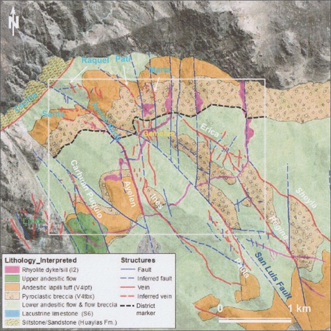
| Figure 9-7 | Extent of vein mapping during 2021-2023 within the area surrounding the Ayelén occurrence |
Two of the veins found comprised the closely spaced north-south trending quartz veins, referred to as the Gemelas veins. These were traced up to 110 m length with widths up to 1.20 m. Ten samples were taken, and the West vein (Figure 9-8) returned values up to 13.6 g/t Au and 14.35 g/t Ag.
| Technical Report on the San Luis Property | 68 |
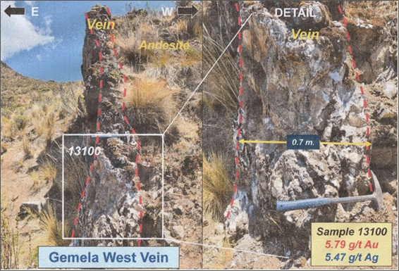
| Figure 9-8 | Crop out o9-7 f the Gemela West Vein approximately 1 km northeast of the Ayelén zone (right-hand inset photograph shows the vein in more detail) |
Table 9-2 summarizes highlights of the other veins found and sampled, although these results have not been checked by the QP.
| Table 9-2 | Highlights from veins mapped during 2021-2023 |
VEIN |
Traceable |
Width |
Highest grades sampled | |
| g/tAu | g/tAu | |||
| Cenicienta | 90 m | <1.0 m | 13.60 | |
| Gemelas West | 110 m | <1.0 m | 11.00 | |
| Gemelas East | 90 m | 0.2 m | 22.00 | |
| Maria | 160 m | 0.2 m | 1.60 | 127 & 183 |
| Pati | 300 m | <0.6 m | 1.24 | 77.2 |
| Cecilia | 1.5 Km | >0.4 m | 2.58 | 622.0 |
| Linda | 600 m | <1.1 m | 6.64 | 92.1 |
Source: Reliant
Revision of the 2006–2007 drill cores was also being carried out at the same time, and from which it was recognized that the gold mineralization in the Ayelén vein is controlled not only by structures but also by lithology. Whilst the Ayelén vein is spatially related to northwest-trending steep fault where it is emplaced along with two-stages of rhyolite dyking, it is now interpreted that the gold mineralization is probably related to a lithological arrangement when andesitic flows contact the footwall and an andesitic tuff contacts the hangingwall. Furthermore, the combined relationship between the magnitude of fault displacement and the gold endowment (Rhys et al., 2020) is an important feature to be considered (Figure 9-9).
| Technical Report on the San Luis Property | 69 |
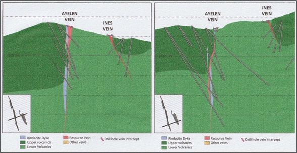
| Figure 9-9 | Two cross-sections through the Ayalén and Inés veins indicating a possible relationship between the mineralization and the faulted juxtaposition of the Upper Volcanics |
It is this feature that has been taken into consideration with regards to the target generation process for low-sulphidation epithermal veins in the San Luis Property, and where faulting along the Ayelén West vein and Carhuan Puquio veins to the west of Ayelén (Figure 9-10) indicates a similar faulting and wall- rock association to that identified adjacent to the Ayelén and Inés veins.
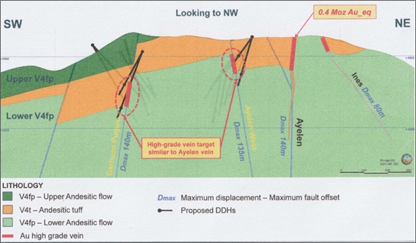
| Figure 9-10. | Northeast-southwest cross section showing the relationship between mineralization, faulting, and lithology adjacent to the Ayelén vein may be repeated in the case of the Ayelén West and Carhuan Puquio veins further to the west and southWest, and where drilling is being considered |
| Technical Report on the San Luis Property | 70 |
Reliant has consequently proposed (September 2023) an initial drilling program comprising 10 widely spaced drillholes (80–100 m spacing) aimed at the down-dip extension of the Ayelén West vein and totalling 1,890 m, and nine similarly spaced drillholes aimed at the down-dip extension of the Carhuan Puquio vein. The QP is in general agreement with this proposal, with the exception that results from the shallow drillholes should be evaluated prior to drilling the deeper holes. The Gemelas veins warrant further sampling and possible drilling as well.
Also proposed was a program of 10 drillholes aimed at probing the possible in-depth extensions of the Ayelén vein. However, in this case the QP is not in agreement with Reliant’s proposed deep drilling, when the cost would be better spent on the necessary drilling required to increase confidence and convert Indicated Mineral Resources to Measured Mineral Resources at and near surface.
Other work carried out during this period, was to re-log and carry out further drillhole sampling of the wall-rocks of the Ayelén and Bonita zones with a view to evaluating the open pit bulk mining of these deposits. However, the QP has reviewed the additional sampling and assaying data and considers that bulk tonnage at Ayelén is unlikely to add any value to the project, and that no opinion can be given in the case of the Bonita zone until the proposed trenching and diamond drilling has been carried out.
The last project work carried out by Reliant included re-evaluation of the 2009 geological model and Mineral Resource estimate. However, this work was carried out in-house, not checked externally, and is not therefore considered relevant to the information supporting the current technical report.
| Technical Report on the San Luis Property | 71 |
| 10 | DRILLING |
The property has been tested by 184 bore holes, totalling 43,949 m of diamond drilling.
Table 10-1 summarizes the diamond drilling carried out on each of the tested exploration targets within the property.
| Table 10-1 | Summary of 200C–2012 diamond drilling |
| Exploration Target | Year | No. of holes | Total metres |
| Ayelén & Inés | 2006-07 | 129 | 31,471.60 |
| Ayelén metallurgical samples | 2007 | 7 | 882.40 |
| Scout drilling (other veins) | 2007 | 23 | 4051.00 |
| BP Zone | 2007-08 | 23 | 7,254.00 |
| Bonita Vein | 2012 | 2 | 290.00 |
| Total Drilling | 2006-12 | 184 | 43,949.00 |
A summary of all holes drilled, their target, coordinates, azimuth, angle and depth is presented in Appendix B of this report. A summary of all the principal drillhole intersections is presented in Appendix C.
On September 25, 2006, Reliant (then owned by Esperanza) commenced the first drilling program on the San Luis Property. A minimum of 4,000 m of HQ-size diamond drilling was proposed to evaluate the indicated higher-grade sections of the Ayelén and Inés vein structures as well as other vein targets on the property. At the time of the Pincus and McCrea technical report (November 22, 2006), 12 drillholes had been completed, totalling 1,500 m, and the drill core assay results from the first four drillholes were reported.
Between September 25 and December 16, 2006, Reliant (now under joint venture between Esperanza and SSR Mining) completed 28 HQ-size bore holes, totalling 3,764.9 m, to initially test the central portion of the Ayelén vein structure and northwest portion of the Inés vein structure (Figure 10-1).
| Technical Report on the San Luis Property | 72 |
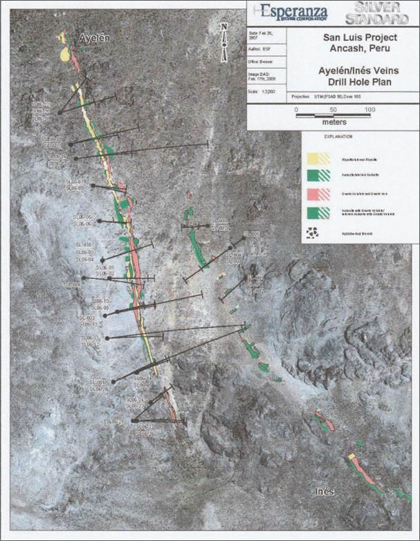
| Figure 10-1 | 2006 drillhole locations re the Ayelén and Inés vein structures |
Source: Reliant
| Technical Report on the San Luis Property | 73 |
Drilling resumed on January 10, 2007, and during the next 10 months Reliant drilled an additional 133 HQ-size diamond drillholes. This work continued the evaluation of the Ayelén and Inés vein structures and tested the other five veins of the San Luis vein system. The final four drillholes of the 2007 field season tested several exploration targets within the BP zone with the last 2007 drillhole (BP-SL-133) being completed on October 18, 2007.
Boart Longyear of Lima, Peru was the diamond drilling contractor for all of the drilling. Boart Longyear provided two diamond drill rigs, namely LF-70 and LY-44 rigs, capable of recovering HQ-size and NQ- size core. All drillholes were started with HQ-size equipment and only occasionally reduced to NQ-size if poor ground conditions were encountered.
Heavy equipment was utilized to construct drill access roads, drill sites, support the rigs during drilling, and to rehabilitate the drill sites afterwards.
The locations of the 2006 drillholes were based largely on positive results from trenching and channel sampling along the Ayelén and Inés vein structures. Subsequent drilling on these structures was positioned to follow mineralized shoots along strike and down dip at a drilling density of ±40 m spacing, sufficient to start modelling the veins and estimate their mineral resources. Drilling on the other vein structures and within the BP zone was directed at coincidental geological, geochemical and/or geophysical targets.
Drillhole collars were reportedly surveyed initially with global positioning system (GPS) instrumentation and later using Distamat surveying techniques. Downhole survey measurements were recorded at 50 m intervals and near the terminus of each drillhole. Occasionally, extra downhole surveys were requested near-surface to obtain a more accurate azimuth and inclination than that determined using a handheld compass. Every downhole survey was recorded on the field geologic log and in the ‘Survey’ of the drilling database.
All drillhole locations were surveyed immediately upon their completion. The confirmed drillhole locations were then entered into their respective databases. The surveyor marked the collar of the drilled hole with a labelled cairn. The relative positions for various holes were regularly checked on plotted maps and drill collars were also regularly checked using handheld GPS units as a quality control (QC) measure.
| 10.1 | Results of the 2006–2007 Drilling Programs |
Drilling results for the central portion of the Ayelén vein structure show that structure is composed of multiple lenticular vein segments resulting from repetitive faulting and shearing during the emplacement of the epithermal quartz veining, auriferous mineralization and later rhyolitic and felsic dyking. The Ayelén vein structure has been traced on surface for 720 m and down dip for 100–327 m along a strike orientation of 340–345°. Within its known strike length, there is a central 400–500 m long section that appears to have been better mineralized with longer drill intercepts. On surface, the vein structure dips -75° to -85° west-southwest, but drilling results show that the controlling fault structure(s), subsurface individual vein segments and post-mineral dykes dip sub-vertically to -80° west-southwest. True thicknesses of individual vein segments vary from tens of centimetres to over 10 m, averaging 1.5–3.0 m wide (Figure 10-2 and Figure 10-3).
| Technical Report on the San Luis Property | 74 |
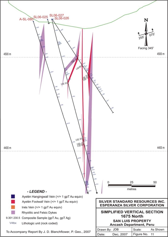
| Figure 10-2 | Drilling section 1C75 north showing the interpreted Ayelén vein and dyke structures |
Source: Blanchflower, 2007
| Technical Report on the San Luis Property | 75 |
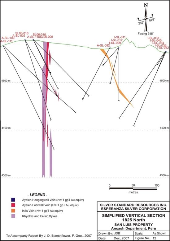
| Figure 10-3 | Drilling section 1825 north showing the interpreted Ayelén and Inés veins, and dyke structures |
Source: Blanchflower, 2007
| Technical Report on the San Luis Property | 76 |
Multiple lenticular vein segments dominantly occur on the footwall or east-northeast side of the dykes in the southern portion of the Ayelén vein structure but occur between and bound the dykes on both sides towards the north-northwest end. Thus, the collective Ayelén vein structure has been subdivided into hanging-wall and footwall sections based upon their relative position with respect to the dyking. The mineralogical and textural features of the various vein segments vary with depth, probably due to vertical zonation during their original epithermal emplacement.
The highest gold and silver grades commonly occur within 100 m of topographic surface but may extend to vertical depths of 200 m or more. Very fine-grained pyrite, native gold, native silver, electrum, acanthite, sphalerite, chalcopyrite, galena and possible tetrahedrite occur in paragenetically late quartz
+ sericite ± calcite veinlets and breccias-fillings. The main lithological types logged in the drillholes are summarized in Table 10-2.
Table 10-2 Summary of the main drillhole logged lithologies
| Logged lithologies | Main group | |
| Description | Code | |
| Fault zone | FZ | Fault zone |
| Quartz vein | H1 | Vein |
| Banded quartz vein | H1bd | Vein |
| Quartz vein – hydrothermal breccia | H1bx | Vein |
| Quartz vein – coliform banded | H1cb | Vein |
| Quartz vein – massive | H1m | Vein |
| Carbonate vein | H2 | Vein |
| Banded carbonate vein | H2bd | Vein |
| Carbonate vein – hydrothermal breccia | H2bx | Vein |
| Carbonate vein – coliform banded | H2cb | Vein |
| Carbonate sulphate vein | H5 | Vein |
| Carbonate sulphate vein – hydrothermal breccia | H5bx | Vein |
| Carbonate sulphate vein | H5m | Vein |
| Hydrothermal breccia | H7 | Vein |
| Hydrothermal breccia – coliform banded | H7cb | Vein |
| Rhyodacite dyke | I2 | Intrusive dyke |
| Rhyodacite – flow banded | I2fb | Intrusive dyke |
| Rhyodacite – feldspar porphyry | I2fp | Intrusive dyke |
| Rhyodacite – quartz feldspar porphyry | I2qfp | Intrusive dyke |
| Rhyodacite – quartz porphyry | I2qp | Intrusive dyke |
| Rhyodacite – spherulitic | I2sphl | Intrusive dyke |
| Intrusive dyke | 13 | Intrusive dyke |
| Tuff breccia | Tbx | Breccia |
| Andesite | V4 | Lower volcanic sequence |
| Andesite – ash tuff | V4at | Upper volcanic sequence |
| Andesite – brecciated | V4fbx | Upper volcanic sequence |
| Andesite – feldspar porphyritic | V4fp | Upper volcanic sequence |
| Andesite – lapilli tuff | V4lpt | Upper volcanic sequence |
| Andesite – mafic porphyritic | V4mp | Upper volcanic sequence |
| Andesite – brecciated tuff | V4tbx | Upper volcanic sequence |
| Technical Report on the San Luis Property | 77 |
The Inés vein has been traced on surface for over 2,200 m, trending northwest at 320–340°. The main controlling brittle-ductile structure appears to be a listric fault, since the vein dips about -75°eastwardly near surface then progressively more gently at -60° to -45° as it is traced downwards, and that it may intersect and possibly rotate the strike of the adjacent Ayelén vein structure slightly northward.
The better mineralized section of the Inés vein is where it is in close proximity to the Ayelén vein and where it has sizeable epithermal quartz veining. Otherwise, it has the appearance of a brittle-ductile fault zone, approximately 1–5 m wide, hosting anastomosing veinlets of quartz and tectonic breccia healed by quartz and coarse-grained calcite. The results of 28 diamond drillholes along a 475 m long section of the Inés vein structure indicate that only a short section, perhaps 100 m in strike length, is host to potentially economic gold-silver mineralization.
The results from the scout drilling conducted beyond the Ayelen and Ines veins are considered preliminary and inconclusive regarding the complete nature and full potential of the partially tested structures. This is because individual structures can host multiple hydrothermal stages. Nelson (2006) discusses the complex history of quartz and carbonate precipitation in some of these veins (e.g., Regina), including the presence of lattice textures in the quartz matrix.
The Paula vein structure has been tested to depths of 50–255 m from surface with 12 diamond drillholes spread out along a 350 m long section of its known strike length. This drilling intersected the inferred vein structure but only intercepted zones of discontinuous thin quartz veins and veinlet stockworks with minor fine-grained pyrite and occasional chalcopyrite. None of the intercepts yielded significant gold or silver values. However, this drilling also intersected a ‘blind’ vein structure, named ‘Cristina’, that hosted geochemically significant gold and silver values which should be investigated during future drilling work.
Five diamond drillholes tested the Regina vein structure to vertical depths of between 50 m and 250 m. Only slightly anomalous gold values were encountered in one drillhole (R-SL-54).
Four drillholes intersected the Sheyla vein structure between 65 m and 125 m below surface. Only traces of fine-grained pyrite and acicular tourmaline were encountered in the vein intercepts with no significant gold and silver values.
Two drillholes tested the Puca-Puca quartz stockwork zone. Only one hole cut the stockwork 75 m below surface, but it did not intersect any significant gold or silver values.
Four drillholes were completed on the newly discovered BP zone during October 2007. These holes were directed to test several coincident ground magnetics and induced polarization anomalies situated centrally within the zone. According to the joint Esperanza-Silver Standard press release dated November 15, 2007:
| ● | “Drillhole SL-131 was drilled within the outcrop area of hydrothermal breccia and from surface encountered 45 meters containing 0.53% copper, C2.7 grams per tonne silver, 0.02 grams per tonne gold, 0.11% lead and 0.10% zinc. |
| ● | Drillhole SL-130 was drilled approximately 300 meters northwest of the outcropping breccias and was designed to test a geophysical anomaly. This hole encountered a 54-meter section of hydrothermal breccia containing 0.11% copper and anomalous silver, gold, lead and zinc. This intersection possibly expands the area of the known mineralized breccia or indicates the presence of multiple breccia bodies. |
| Technical Report on the San Luis Property | 78 |
| ● | Drillholes SL-132 and SL-133 were drilled west and southwest respectively of the outcropping breccia and were designed to test additional geophysical anomalies. Although there was porphyry-style alteration they did not yield significant metal values.” |
In summary, the last two drilling campaigns have successfully shown that portions of the Ayelén and Inés vein structures host potentially economic gold and silver mineralization, some of which has bonanza grades. Initial drilling within the BP zone has shown there are multiple mineralized breccia bodies centrally located within the zone, and that this mineralization and the locally intense porphyry-style alteration may be indicative of a buried intrusion with significant exploration potential.
The drillhole spacing of ±40 m was considered sufficient by previous QPs to model and estimate the Mineral Resources of the Ayelén and Inés vein structures. In the experience of the current QP infill drilling would be required to convert Indicated Resources to the Measured category.
The QP notes there are indications that the Ayelén vein mineralization is possibly open both to the north and the south. Further exploratory drilling is therefore recommended along the continuing strike of this vein.
The historic sampling methods and sample quality were not in line with current reporting standards but were considered sufficient for the purposes for which they were used. There was bias detected between surface chip channel sampling and drill core data, and for this reason the surface sampling was discounted when the mineral resource estimate was carried out because the drill hole sampling gave the most representative results.
| Technical Report on the San Luis Property | 79 |
| 11 | SAMPLE PREPARATION, ANALYSIS AND SECURITY |
| 11.1 | Surface Trench Sampling |
Pincus (2006) records that surface trenches were sampled by cutting material (using a hammer and chisel) from channels in the floor of the trenches after the floors were cleaned by pick and shovel. Based on Reliant’s examinations of the surface trenches during a 2008 site visit, the samples taken were not true channel samples (where material was carefully removed such that well defined, regular rectangular cuts remained). Rather, the surface trench samples appeared to be what is well known and accepted in the industry as “chip channel” samples. Individual sample locations were then marked by spray paint continuously along the entire length of the trench (see Photograph 15, Section 9). Each sample was cut along a length of approximately 1 m, although the lengths of individual samples varied. Each individual sample generally weighed between 1 kg and 2 kg.
| 11.2 | Drill Core Sampling |
Diamond core recovery for the various drill campaigns is recorded as excellent. Fifty-six percent of the assayed intervals had a core recovery of 100% and 95% of the total data had core recoveries in excess of 90%. The San Luis project geologists who logged the core determined the core intervals to be sampled. Sample intervals averaged approximately 1.0 m in length, with individual samples rarely greater than 1.5 m or less than 0.5 m in length. Definite sample breaks were reportedly made at contacts between geologic units (vein/wall-rock boundaries and lithologic contacts). Within an individual geologic unit, sample intervals were extended or reduced slightly to allow for a nearby geologic contact. The maximum allowable sample length was 2.0 m.
Once the project geologists marked the sample interval breaks, core from each assigned sample interval was individually removed and cut in half lengthwise using a diamond saw. After sawing the core from an individual sample interval, one-half of the drill core was placed in a 6 mm thick plastic sample bag for assay, and the other half was returned to its original position in the core box. All the core from the 10 holes examined during the June 2008 site visit were found to be well sawn, with the remaining half core carefully placed back in the boxes in good order.
| 11.3 | Sample Security and Chain of Custody Procedures |
Once trench or core sampling was complete, the individual sample bags were then securely tied with non-slip plastic straps, properly labelled and then transferred to a locked room in the camp facility under the supervision of the project geologist, and until they could be despatched to the assay laboratory.
Prior to despatch, the individual bags of samples were placed into large woven nylon rice bags, the contents were marked on each rice bag, and each rice bag was securely sealed. These rice bags containing the individual samples were then delivered directly to either the SGS del Peru S.A.C. in Lima or the ALS Chemex assay laboratory in Lima by project personnel, thus maintaining an uninterrupted chain of custody between the sampling point and the assay laboratory.
Occasional exceptions to this procedure occurred when trench samples were delivered by project personnel to the town of Casma, from which the samples were then transferred via commercial transport (TEPSA S.A.) to Lima and picked up from the terminal by arrangement by SGS.
| Technical Report on the San Luis Property | 80 |
| 11.4 | Sample Preparation and Analysis |
During the exploration of the San Luis veins, sample preparation and analysis was carried out by various laboratories, including SGS del Peru S.A.C. in Lima, Peru (2006), and ALS Chemex Peru S.A. in Lima (2007). Both laboratories are accredited according to the ISO/IEC 172025 standard, which is specifically designed for Mineral Analysis Testing Laboratories. The sample preparation and analytical procedures used by these laboratories (as described in Blanchflower (2007) and Pincus and McCrea (2006)) are appropriate for the type of epithermal gold-silver mineralization present in the San Luis deposit.
No aspects of the sample preparation or sample analysis were conducted by an employee, officer, director, or associate of either Silver Standard or ESC, its joint venture partner in the San Luis Project.
| 11.4.1 | Sample Preparation |
Previous Technical Reports state that “upon arrival at the SGS or ALS Chemex laboratory the drill core samples were logged into their system. Each sample would have been placed into a stainless steel tray and dried in an oven set not to exceed 105o C for approximately 4 to 8 hours, the timing being dependent upon its moisture content. Then each sample was progressively crushed by primary and secondary crushers until more than 70% of the crushed sample passed through a 2 mm (Tyler 10 mesh) screen. Standard crushing practises also included repeatedly cleaning the crusher prior to, during and after each sample batch using coarse quartz material, and air cleaning the crushers after each sample.
The sample material was then riffle split to obtain approximately 250 to 500 grams and the remaining coarse reject material was returned to RVSAC for storage in their Lima warehouse for possible future use. The 250 to 500 gram sample, size dependent upon requested analyses, was pulverized using a ring pulverizer until 85% of the pulverized material passed through a 75 micron (Tyler 200 mesh) screen. Then 250 grams of finely pulverized material was transferred to a paper envelope for later analytical work. This same preparation procedure was used for both rock chip and drill core samples.”
| 11.4.2 | Analyses |
Records indicate that various methods of analyses were used for the determination of gold and silver content. For gold determination, two methods of analyses have been employed by SGS. The first method (SGS Code FA313) is a fire assay of a 30 g charge followed by an atomic absorption spectroscopy (AAS) determination. The lower and upper detection limits of this method are 0.005 ppm and 5.0 ppm. When the analytical result of a sample exceeds 5 ppm, the sample is re-analyzed using a second method (SGS Code FAG303). The FAG303 method is fire assay of a 30 g charge with a gravimetric finish.
For the determination of silver, two methods of analyses were utilized. The first method (ICP40B) is a four-acid digestion of a 0.25 g sample followed by a silver determination using induced coupled plasma optical emission spectroscopy (ICP-OES) instrument. The four acids used in the digestion are: HCl (hydrochloric acid), HNO3 (nitric acid), HF (hydrofluoric acid), and HClO4 (perchloric acid). The lower and upper detection limits of this method are 0.2 ppm and 100 ppm. When analytical results exceed 100 ppm, the sample is re-analyzed using a second method (SGS Code AAS41B now termed AA_TO4). A 0.25 g sample is digested using four acids and silver is determined by AAS instrumentation.
Multi-element analyses were also carried out using the ICP40B method, aqua-regia digestion, and 35 element concentrations are determined by ICP-OES. The major and minor elements determined are: Al, Ca, Fe, K, Mg, Na, S, Ti, As, B, Ba, Be, Bi, Cd, Co, Cr, Cu, Ga, La, Mn, Mo, Nb, Ni, P, Pb, Sb, Sc, Sn, Sr, Tl, V, W, Y, Zn, Zr.
| Technical Report on the San Luis Property | 81 |
| 11.4.3 | Quality Assurance and Quality Control |
Following the start of exploration activities Reliant established a quality assurance (QA) program utilizing QC samples to monitor accuracy (standards), contamination (blanks), precision (duplicates), and sample mix-ups.
Sample results were reportedly monitored on a real-time basis by the database manager, and any QC sample failures were reported to the laboratory and check analyses were carried out in order to rectify the failure.
The QA program comprised the insertion of QC samples at a rate of approximately 7% or one sample per 15 samples submitted to the laboratory. Secondary cross-check analyses (replicates) are then carried out by the laboratory at a rate of 5%.
QC samples were reportedly inserted randomly into sample batches and within every 15 consecutive samples, rotating between the insertion of a standard, blank, or duplicate sample. The standard and blank samples are inserted into the sequence of samples as they are prepared for shipment to the SGS laboratory, while field duplicate samples are collected in the field at the same time as the original sample collection or comprised quartered core.
The QC samples use the same numbering sequence as regular samples and are not identified in any other manner other than being in a smaller sample bag identifiable by number only.
However, the QP notes that there was no evidence that the assay results were reviewed on a batch by batch or regular basis, in order to eliminate importing erroneous data into the database and 3-D modeling, because there was no such reporting other than that carried out once by McCrea in 2007.
Insertion of Certified Reference Materials (Standards)
The three standards (certified reference materials – CRMs) reportedly used on the San Luis Property were developed in-house using coarse reject rock material from samples collected at San Luis (Zuker, 2006). The gold and silver accepted values of the three standards are shown in Table 11-1 and Table 11-2, respectively. When results do not fall within these plus and minus three (±3) standard deviations (SD), the result is considered to have failed and appropriate actions are taken.
| Table 11-1 | Accepted gold values and ranges for the San Luis standards |
| Standard | Mean (g/t Au) | SD | Mean -3 SD | Mean +3 SD |
| SL1 | 82.5 | 1.27 | 78.69 | 86.32 |
| SL2 | 29.2 | 0.78 | 26.84 | 31.5 |
| SI3 | 3.74 | 0.11 | 3.41 | 4.07 |
| Table 11-2 | Accepted silver values and ranges for the San Luis standards |
| Standard | Mean (g/t Ag) | SD | Mean -3 SD | Mean +3 SD |
| SL1 | 1,764.0 | 24.58 | 1,690.0 | 1,838.0 |
| SL2 | 1,033.0 | 23.90 | 961.0 | 1,106.0 |
| SI3 | 122.5 | 2.998 | 113.5 | 131.5 |
The rock material used for the development of the standards was crushed, pulverized, screened, split into 75 g subsamples, placed into plastic bags, sealed and labelled by SGS del Perú Labs. The gold and silver values for these three standards were established from multiple assays by SGS del Perú and ALS Chemex Perú laboratories.
| Technical Report on the San Luis Property | 82 |
When a standard is inserted into a batch of samples, one of the sealed bags is placed, intact, without standard identification, into a numbered sample bag, and tied shut.
McCrea (2007) made an independent check of the QAQC protocol and results for the 2006 trench sampling and assays results, and made the following observations:
| ● | “The current assay protocol has the standards submitted to the lab as pulp bags with bags of broken rock. This is not a blind submission but this is industry standard practice as no other practical method for submitting standards is in common use. |
| ● | The standards that Reliant had fabricated, did not have certified values. The prepared standards did not undergo a round robin analysis. The standards were submitted to two labs for 15 to 20 analyses and a third lab is in process.” |
Nevertheless, McCrea was of the opinion that the performance of the prepared standards meets NI 43-101 standards.
Insertion of Blanks
With reference to the insertion of “blanks”, McCrea notes that Reliant used quartz sand as blank material which had been purchased from SGS Mineral Laboratories of Lima, Peru. The blanks were inserted on a 1-in-50 basis. The assays of the blank material indicated “that there is some very minor silver contamination of the blank material, although the blanks show no anomalous values for gold or silver.”
Insertion of Field Duplicates
Reliant submitted 22 duplicate trench chip samples for assaying in the 2006 program. Scatterplots prepared by McCrea are skewed indicating one erratic high grade point and some scatter around 100 ppm to 200 ppm Ag. In this case, both the gold and silver results were based on a small population set from which McCrea concluded that the results “show no bias, and the erratic point is possibly due to a sample mix up.”
Reliant submitted duplicate samples during the 2006–2007 drill program. The “assays Masterfile” records that 136 duplicates out of a total 5,130 drill-core samples were submitted for assay, and representing a 2.65% insertion rate. Although scatterplots of original assays vs the duplicate assays show no marked bias, a little scatter is noted above 3 g/t Au for gold (Figure 11-1), and silver has some scatter around 1,000–1,500 g/t for silver (Figure 11-2).
| Technical Report on the San Luis Property | 83 |
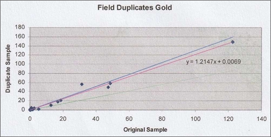
| Figure 11-1 | Duplicate core sample assays – Au ppm scatterplot |
Source: McCrea, 2007
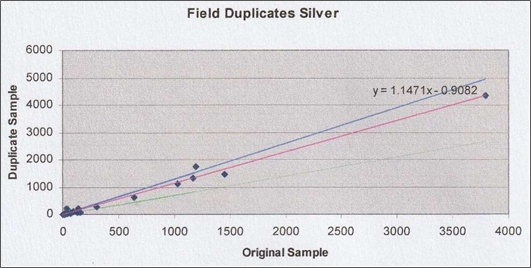
| Figure 11-2 | Duplicate core sample assays – Ag ppm scatterplot |
Source: McCrea, 2007
The QP has reviewed the “Masterfile” which contains the raw data and has confirmed the duplicate sampling results in the following plots (Figure 11-3). Some minor data management issues with the numbers were noted, but nothing that invalidates the comparison.
| Technical Report on the San Luis Property | 84 |
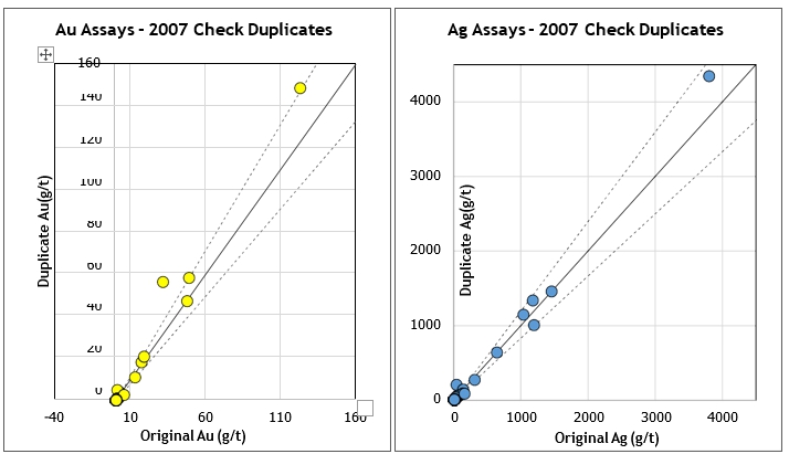
| Figure 11-3 | 2007 duplicate core sample assay results for gold (left); 2007 duplicate core sample assay results for silver (right) |
McCrea (2007) noted that the silver distribution is tighter than that for the gold. However, neither indicates apparent bias (Figure 11-4 and Figure 11-5).
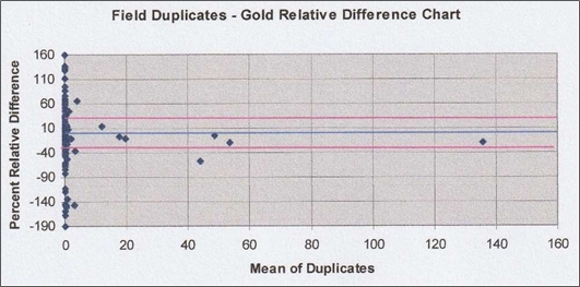
| Figure 11-4 | Duplicate core sample assays – Au ppm relative difference chart |
Source: McCrea, 2007
| Technical Report on the San Luis Property | 85 |
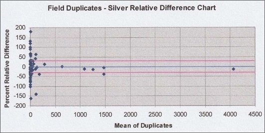
| Figure 11-5 | Duplicate core sample assays – Ag ppm relative difference chart |
Source: McCrea, 2007
Independent Laboratory Checks
Reliant submitted 62 samples to ALS Chemex for check assays. The 62 samples contained three standards and one blank. The samples submitted for check assay were randomly selected from the trenching results in both veins sampled. McCrea concluded “that the check assay results had good reproducibility.”
Based on the limited reporting of the historic sample preparation, sample security and analytical procedures reviewed by the QP, together with the quality of the assay pulps and duplicates stored and checked by the QP in Lima, it is the author’s opinion that the sample preparation, security and analytical procedures were carried out in an acceptable manner and that the data used in the updated estimate are adequate for the purposes of this technical report. Nevertheless, it is important to emphasize that sampling and QA-QC procedures have been improved since 2006-7, and that these will need to be reviewed and improved upon in the future.
| Technical Report on the San Luis Property | 86 |
| 12 | DATA VERIFICATION |
Data verification has comprised the review of QAQC data included in Item 11, the project site visit carried out on March 20–21, 2024, and a visit to the sample store completed on March 22, 2024, following return to Lima.
In addition to the site visit, systematic checking of database inputs, sample numbering and assay certificates (13% checked without showing errors) was carried out during the process of reviewing the project databases, and the data which was included in the geological interpretation and modelling, and the subsequent review of Reliant’s 2010 historical Mineral Resource estimate.
| 12.1 | Verification of Surface Sampling Trenches and Drillhole Collars |
| 12.1.1 | Trenches |
Some 19 years have passed since the sample trenches had been carried out, and although there is little vegetation on site, the trenches are partly if not wholly obscured by thin soil and vegetation cover except for areas where the rock (vein and host-rocks) crops out at surface. For this reason, no complete trench was discernible, and there were indications that further trenching may need to be carried out.
As for the quality of trench sampling, this comes under the title of “chip-channel” sampling, no attempt having been made to saw the channels in order to acquire better samples (Figure 12-1).
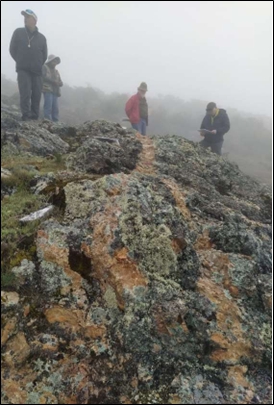 |
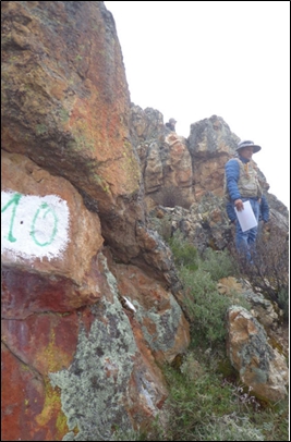 |
| Figure 12-1 | Ayelén trench 13 (left) and Ayelén trench 10 (right) |
| Technical Report on the San Luis Property | 87 |
| 12.1.2 | Drillhole Collars |
All drillhole collars are marked by stand-up plastic piping and a metal collar ID set into cement adjacent to the collar (Figure 12-2 and Figure 12-3).
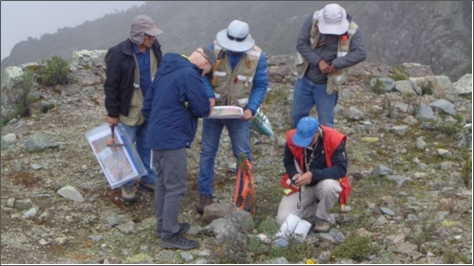
| Figure 12-2 | Checking coordinates for two of the drillhole collars |
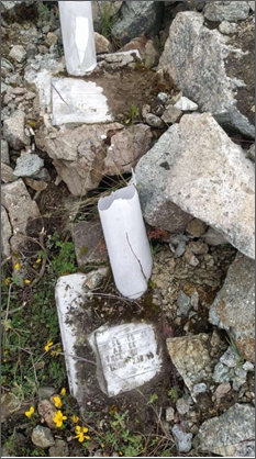 |
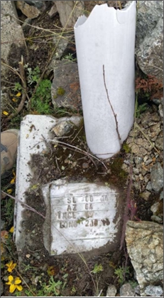 |
| Figure 12-3 | Collar to SL06-15 (left) and collar to SL06-14 (right) |
| Technical Report on the San Luis Property | 88 |
Nine of the 108 Ayelén drillhole collars (8%) were checked by GPS and found to be satisfactorily located in relation to the drillhole database (Table 12-1). Other drillhole collars were visually noted to be in their mapped positions.
| Table 12-1 | Summary of drill collars checked on site |
| Hole ID | Database – PSAD56 | GPS site check – PSAD56 | Difference | ||||||
| E | N | Elevation | E | N | Elevation | E | N | Elevation | |
| SL06-028 | 190,436.7 | 8,960,747.5 | 4,576.04 | 190,436 | 8,960,748 | 4,580 | 0.8 | -0.2 | -4.0 |
| A-SL-0001 | 190,436.6 | 8,960,747.6 | 4,575.99 | 190,436 | 8,960,748 | 4,580 | 0.7 | -0.2 | -4.0 |
| SL06-014 | 190,469.2 | 8,960,760.4 | 4,569.96 | 190,468 | 8,960,760 | 4,577 | 1.3 | 0.7 | -7.0 |
| SL06-015 | 190,468.4 | 8,960,760.0 | 4,570.01 | 190,468 | 8,960,760 | 4,577 | 0.5 | 0.2 | -7.0 |
| SL06-001 | 190,431.8 | 8,960,886.7 | 4,580.48 | 190,432 | 8,960,888 | NA | -0.1 | -1.0 | |
| SL06-002 | 190,431.4 | 8,960,886.8 | 4,580.38 | 190,432 | 8,960,888 | NA | -0.5 | -1.0 | |
| SL06-016 | 190,388.2 | 8,961,047.1 | 4,534.87 | 190,389 | 8,961,046 | 4,551 | -0.7 | 1.3 | -16.1 |
| SL06-017 | 190,338.5 | 8,961,047.0 | 4,534.91 | 190,389 | 8,961,046 | 4,551 | -0.4 | 1.2 | -16.1 |
| A-SL-0028 | 190,385.6 | 8,961,046.5 | 4,534.97 | 190,389 | 8,961,046 | 4,551 | -3.3 | 0.8 | -16.0 |
| 12.2 | Verification of Drill Core Logging |
Prior to arriving on site, Reliant was given a selection of Ayelén vein and adjacent wall-rock intercepts that the QP and accompanying geologists wanted to inspect, and which related to high-grade zones within Sections 10, 14 and 20 of the geological model. The cores inspected are summarized in Table 12-2, Table 12-3 and Table 12-4.
| Table 12-2 | Summary of drill cores inspected within Model Section 10 |
| Drillhole | Core inspected | Vein zone | |||
| From | To | From | To | Observations | |
| A-SL-001 | 121.00 | 137.00 | 126.10 | 136.00 | Main vein: high grade values |
| A-SL-001 | 137.00 | 144.30 | 138.00 | 141.87 | Branch vein: very low grade |
| A-SL-064 | 182.20 | 202.75 | 187.20 | 197.25 | High grade vein zone |
| A-SL-066 | 215.00 | 233.00 | 225.85 | 226.98 | V. narrow vein and no Au-Ag values |
| SL06-14 | 29.65 | 44.90 | 35.03 | 36.40 | Mixed medium-low Au-Ag grade |
| SL06-15 | 51.90 | 71.00 | 58.55 | 66.63 | Variable low to medium grades |
| SL06-28 | 87.50 | 104.45 | 93.15 | 97.46 | Narrow high-grade vein zone |
| Table 12-3 | Summary of drill cores inspected within Model Section 14 |
| Drillhole | Core inspected | Vein zone | |||
| From | To | From | To | Observations | |
| A-SL-006 | 136.20 | 150.00 | 139.30 | 143.30 | Some included wall-rock |
| A-SL-016 | 174.50 | 186.00 | 174.50 | 186.00 | No sign of the vein |
| A-SL-114 | 105.00 | 126.00 | 114.40 | 120.00 | Variable high-grade Au-Ag |
| SL06-01 | 37.25 | 60.00 | 45.00 | 55.08 | Wide vein zone: variable grades |
| SL06-02 | 63.55 | 82.00 | 68.47 | 78.40 | Wide vein zone: variable grades |
| Technical Report on the San Luis Property | 89 |
| Table 12-4 | Summary of drill cores inspected within Model Section 20 |
| Drillhole | Core inspected | Vein zone | |||
| From | To | From | To | Observations | |
| A-SL-028 | 60.73 | 86.00 | 71.14 | 80.26 | Some Au-Ag in wall-rocks |
| A-SL-045 | 195.00 | 209.00 | 200.30 | 204.20 | Variable high grade |
| A-SL-084 | 75.36 | 91.10 | 81.35 | 85.35 | Low grade branch vein? |
| A-SL-084 | 114.00 | 130.00 | 119.00 | 124.10 | Main vein zone |
| SL06-16 | 38.90 | 51.00 | 44.55 | 50.00 | Main vein zone |
| SL06-16 | 51.00 | 59.00 | 51.85 | 55.00 | Branch vein with values |
| SL06-17 | 45.00 | 61.57 | 49.60 | 59.80 | Wide zone – variable grade |
| SL06-17 | 61.57 | 79.35 | 62.42 | 77.95 | Wide zone high-grade Au-Ag |
| SL06-17 | 79.35 | 85.99 | 80.50 | 81.70 | Narrow branch vein: little value |
| SL06-19 | 69.00 | 82.40 | 73.75 | 77.73 | Low grade with included breccia |
Amongst other observations made when comparing sample records with the drill logs, was that not all geological modelling represented the full width of the vein when very low-grade vein material occurred adjacent to wall-rock. In addition, it was also noted that some vein sampling goes beyond the wall-rock boundary, as shown in Figure 12-4.
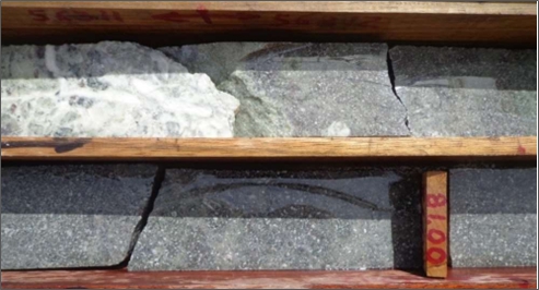
| Figure 12-4 | Sawn core from drillhole SL06-02 shows sampling continuing beyond the vein boundary |
Further to inspection of the drillholes within Model Sections 10, 14 and 20, three drillhole vein intercepts were also inspected to the extreme north, south and in depth of the deposit explored to date. It was concluded that exploration had not reached the limits of gold-silver mineralization, and that further exploration in all three directions is warranted (Table 12-5). For example, the QP was advised that the southern extension of the vein zone was not explored any further due to coverage by superficial deposits.
| Technical Report on the San Luis Property | 90 |
| Table 12-5 | Summary of surrounding drill cores inspected to the north, south and in depth |
| Drillhole | Vein zone | ||
| From | To | Observations | |
| SL06-26 | 69.90 | 74.30 | Mineralization open to the north |
| A-SL-077 | 38.46 | 45.80 | Mineralization open to the south |
| A-SL-104 | 273.40 | 282.73 | Further exploration required in depth |
It was concluded from the drill-core inspections that more information can be recovered by re-logging the main vein intercepts and their adjacent wall-rocks. This to improve the geological model in relation to mine design, and this should include more detailed geotechnical logging using the photographic records to develop a geotechnical model.
| 12.3 | Verification of Assay Results |
It had been the intention to carry out selective re-sampling of some of the main vein intersections by cutting half cores into quarters, but this had already been carried out. However, the results of this re-sampling could not be found by Reliant’s geological team, and it is suspected this may relate to work carried out by Hochschild when they took interest in the San Luis Project.
Assay checks were therefore focused on Reliant’s sample store in Chorrillos, Lima which was inspected on March 22, 2024. This showed a well-preserved and fully documented sample storage system of coarse sample rejects (Figure 12-5) and assay pulps (Figure 12-6).
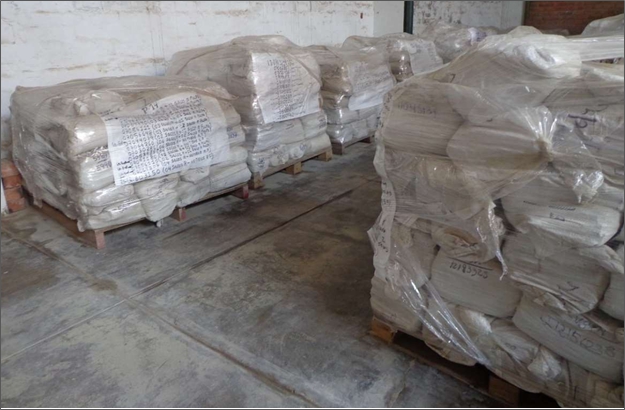
| Figure 12-5 | Documented, bagged and sealed coarse sample rejects on wooden pallets |
| Technical Report on the San Luis Property | 91 |
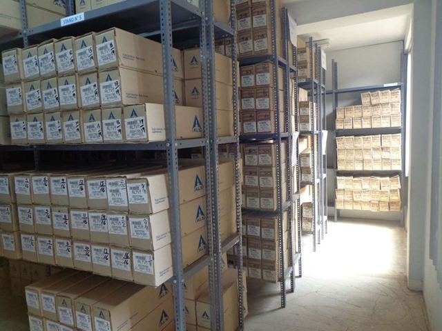
| Figure 12-6 | A well numbered separate assay pulp sample store at Chorrillos |
Coarse sample rejects and sample pulp storage is labelled and coded by year and includes sample batch and number in easily located and systematically shelved boxes within a dust-free room. This includes a computerized database (Figure 12-7) which records details of all samples, including their origin.
| Technical Report on the San Luis Property | 92 |
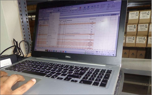
| Figure 12-7 | Access to the computerized database can locate sample pulps within minutes |
Sixty sample pulps were selected for check assaying representing a selection across the full range of original gold assays. Of these, three pulps could not be found (probably used up previously) and one pulp was found by the laboratory to be of insufficient weight for assaying.
Fifty-six assay check samples were therefore selected and submitted to the ALS Lima laboratory together with 11 QC samples comprising four certified blanks, three high-grade CRMs, and three low- grade CRMs.
Table 12-6 shows the check assay results compared with Reliant’s original results and indicates two separate failures for gold and silver respectively, representing a 3.57% failure rate overall which is considered acceptable, being less than the 10% threshold normally accepted.
Table 12-6 also compares the sum-total results for gold and silver assays which indicate that overall the check assays show a +0.45% increase in value, indicating the original assays can be considered as on the conservative side for gold, whereas for silver there is an underestimation shown for the check assays (-4.80%).
| Technical Report on the San Luis Property | 93 |
| Table 12-6 | Summary of the check assay results carried out for HSC |
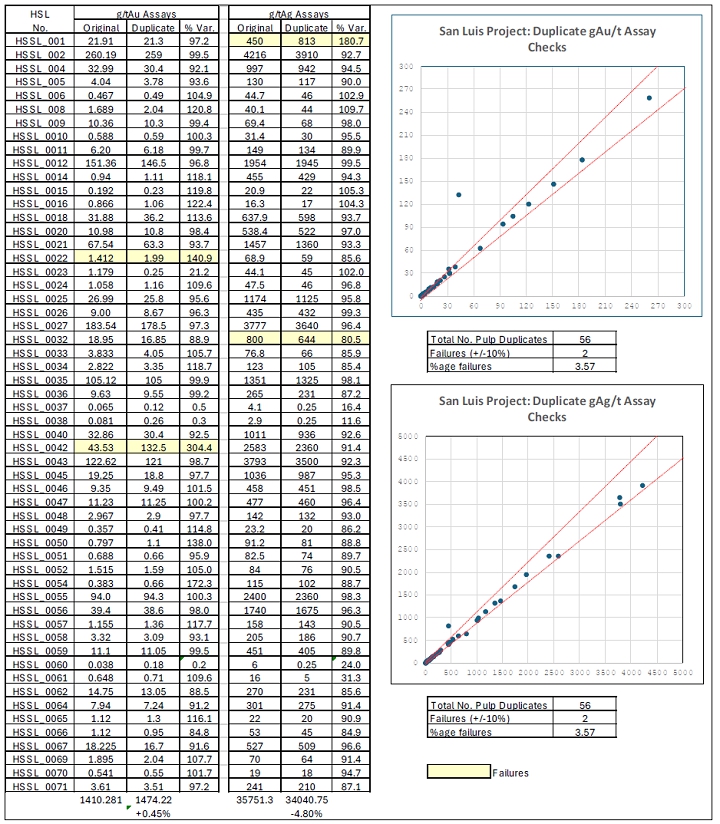
| Technical Report on the San Luis Property | 94 |
Overall, the check assays indicate that the original assaying together with previously Reliant-reported QAQC results, can be considered as adequate for the purposes used herein. As for the inserted control samples, Table 12-7 shows that one of the blanks failed for gold, indicating possible contamination during assaying procedures and indicating a 20% failure rate, whereas all other insertion results can be considered as adequate for the purposes used herein.
| Table 12-7 | Assay results for the inserted control samples |
| INSERTS | TYPE | Au | Ag |
HLSV
Number
|
Au re-assay
GRA22
|
Au re-assay
GRA21
|
Ag re-assay
GRA21
| |
| OREAS 23B | BLANK | <3ppb | 0.065 | HSSL_003 | <0.05 | <0.05 | <5 | |
| OREAS 23B | BLANK | <3ppb | 0.065 | HSSL_0013 | <0.05 | <0.05 | <5 | |
| OREAS 23B | BLANK | <3ppb | 0.065 | HSSL_0028 | <0.05 | <0.05 | <5 | |
| OREAS 23B | BLANK | <3ppb | 0.065 | HSSL_0044 | 0.45 | <0.05 | <5 | |
| OREAS 23B | BLANK | <3ppb | 0.065 | HSSL_0068 | <0.05 | <0.05 | <5 | |
| OREAS 245 | CRM | High grade | 25.7 | 1.44 | HSSL_007 | 25.9 | 25.5 | <5 |
| OREAS 245 | CRM | High grade | 25.7 | 1.44 | HSSL_0030 | 25.4 | 26.1 | <5 |
| OREAS 245 | CRM | High grade | 25.7 | 1.44 | HSSL_0041 | 24.8 | 26.2 | <5 |
| Averages > | 25.4 | 25.9 | ||||||
| -1.2% | +.09% | |||||||
| OREAS 627 | CRM | Low grade | 1.88 | 57.0 | HSSL_0019 | 1.96 | 2.02 | 57 |
| OREAS 627 | CRM | Low grade | 1.88 | 57.0 | HSSL_0053 | 1.91 | 2.00 | 59 |
| OREAS 627 | CRM | Low grade | 1.88 | 57.0 | HSSL_0063 | 1.87 | 1.89 | 53 |
| Averages > | 1.91 | 1.97 | 56,3 | |||||
| +1.6% | +4.8% | -1.23% | ||||||
The ALS assay certificates are included in Appendix D. These are addressed to Minera Cappex S.A.C., a wholly owned subsidiary of HSC.
| Technical Report on the San Luis Property | 95 |
| 13 | MINERAL PROCESSING AND METALLURGICAL TESTING |
The following testwork information has been summarized from Section 18 of SSR Mining’s San Luis Project Feasibility Study (2010).
Following initial advice and guidance from F. Wright Consulting (2008), four metallurgical testwork programs were completed investigating the metallurgical response of mineralized samples from the San Luis Project. The diamond drillhole core sample material provided for testwork is summarized in the reports by Lechner and Earnest (2009) and Kaye et al. (2010). The four testwork programs are summarized in the following sub-items of this report.
| 13.1 | Process Research Associates, Vancouver, Canada |
Five composite samples identified as Ayelén #1 to #5 were prepared from drillhole assay reject material for the Process Research Associates (“PRA”) metallurgical testwork program, as summarized in Table 13-1.
| Table 13-1 | Summary of composite samples provided to PRA |
| Composite | No. diamond drillhole samples | Grade range (ppm Au) | Grade range (ppm Ag) | ||
| From | To | From | To | ||
| Ayelén 1 | 5 | 13.60 | 91.57 | 184.5 | 2,050.7 |
| Ayelén 2 | 3 | 17.97 | 29.90 | 525.3 | 910.7 |
| Ayelén 3 | 3 | 6.73 | 13.25 | 199.6 | 368.9 |
| Ayelén 4 | 3 | 5.42 | 16.18 | 274.7 | 506.4 |
| Ayelén 5 | 2 | 16.02 | 35.62 | 528.8 | 1,254.0 |
PRA carried out 15 gravity pre-concentration tests and achieved gold recoveries in the range of 9.3% to 24.1%, and 1.3% to 4.6% silver recovery. Pan concentrate grades varied from 1,423 g/t and 24,971 g/t Au and from 7,214 g/t to 55,953 g/t Ag. The gravity rougher tests used a Knelson centrifugal concentrator operated in an open cycle single pass.
PRA carried out cyanide leach tests with and without prior gravity concentration and reported the following results, and where the “end” recoveries give similar results (Table 13-2).
| Table 13-2 | Cyanidation results with and without gravity pre-concentration |
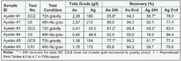
| Technical Report on the San Luis Property | 96 |
Then using a 72-hour leach time, PRA carried out a series of cyanidation leach tests over a range of grind sizes. Their results are summarized in Table 13-3.
| Table 13-3 | PRA results showing the effect of grind size on recoveries |
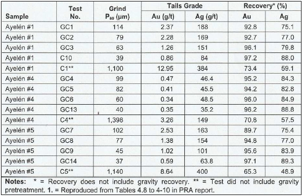
The test results listed in Table 13-3 indicate that gold and silver recoveries increase as primary grind size is reduced from a P80 of approximately 100 µm to a P80 of approximately 40 µm. These preliminary results indicated that a study of grind size optimization is needed. Tests C1, C4 and C5 had very coarse grind (crush) sizes. Such sizes are not typical for leaching. The results demonstrate, however, that a processing alternative such as heap leaching is not suitable.
PRA concludes that although the majority of the gold and silver recoveries is achieved in 24 hours, a 72-hour retention time is indicated to be required given the samples tested and conditions used.
PRA carried out nine bulk flotation tests on gravity concentrate tails to investigate the effect of primary grind sizes on gold and silver recoveries, and found that recoveries of the precious metals improved with finer grind sizes. However, tailings losses were noted to be significant even at the finest grind sizes evaluated. Given the low sulphur contents in the tails, the losses of precious metals are expected to be associated with non-sulphide gangue. Subsequent bulk flotation tests were performed where the gravity circuit was excluded from the circuit.
The results indicated that for a flotation circuit, gravity concentration is not required. A series of flotation tests (open circuit cleaner) at a target primary grind of P80 = 44 µm, without gravity concentration, was also carried out. The results showed that significant gold and silver are still lost to tails. In these tests, the bulk concentrate was subsequently upgraded via three stages of cleaning.
This resulted in concentrates with precious metal grades ranging from 990 g/t to 4,340 g/t for gold and 18,375 g/t to 91,600 g/t for silver. Detailed analysis of the concentrates indicated elevated levels of arsenic and antimony which may have potential penalty issues for smelting.
| Technical Report on the San Luis Property | 97 |
| 13.2 | Plenge Laboratory, Lima, Perú |
One composite sample was prepared from drillhole assay reject material for Plenge’s testwork program. This comprised 13 vein intersections of the Ayelén vein made up from 88 individual samples, as summarized in Table 13-4.
| Table 13-4 | Summary of the composite sample make-up provided to Plenge |
| Drillhole | No. samples | Metres | Grade range (ppm Au) | Grade range (ppm Ag) | |||
| From | To | From | To | From | To | ||
| SL06-26 | 4 | 70.85 | 74.30 | 1.97 | 10.10 | 68.10 | 324.00 |
| A-SL-077 | 5 | 42.10 | 46.80 | 0.38 | 94.00 | 84.00 | 2,400.00 |
| A-SL-069 | 11 | 228.20 | 238.67 | 0.61 | 12.75 | 34.00 | 802.00 |
| A-SL-098 | 9 | 70.35 | 80.96 | 0.30 | 133.50 | 19.00 | 1,680.00 |
| A-SL-124 | 6 | 164.49 | 169.32 | 0.10 | 0.23 | 2.00 | 7.00 |
| A-SL-074 | 8 | 190.75 | 197.10 | 0.02 | 0.37 | 1.00 | 7.00 |
| A-SL-093 | 13 | 94.50 | 106.35 | 0.07 | 1.22 | 3.00 | 39.00 |
| SL06-21 | 6 | 81.95 | 86.33 | 0.47 | 0.70 | 26.00 | 70.10 |
| A-SL-126 | 9 | 129.20 | 135.48 | 2.53 | 207.00 | 104.00 | 8,910.00 |
| A-SL-064 | 9 | 187.20 | 194.25 | 1.05 | 72.50 | 50.00 | 1,855.00 |
| SL06-28 | 3 | 93.85 | 96.46 | 33.47 | 56.06 | 722.00 | 978.00 |
| SL06-11 | 2 | 63.10 | 64.70 | 5.86 | 26.62 | 454.00 | 606.00 |
| SL06-18 | 3 | 49.31 | 51.36 | 2.95 | 83.80 | 185.00 | 1,185.00 |
| 13 holes | 88 | ||||||
NB: No average grades available because sample weights not given.
Plenge carried out three cyanide leach tests at different grind sizes; the results are shown in Table 13-5.
| Table 13-5 | Plenge results showing the effect of grind sizes on recoveries |
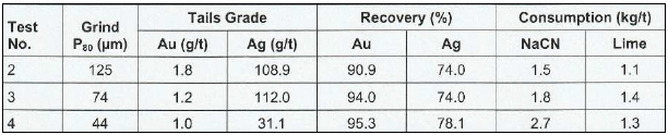
Plenge reports that the recovery of gold does not significantly increase in decreasing the grind size from a P80 of 74 µm to a P80 of 44 µm, however, the NaCN consumption increases significantly. This tends to contradict the PRA results; however, it should be noted that the Plenge tests are very preliminary tests (as are the PRA tests) and on only one sample.
A leach test performed by PRA on material with a head grade similar to that tested by Plenge and at a similar primary grind size (P80 of 77 µm for PRA and P80 of 74 µm for Plenge) produced gold and silver recoveries of 94.8% and 77%, respectively. The comparable Plenge test produced gold and silver recoveries of 94% and 74%, respectively.
| Technical Report on the San Luis Property | 98 |
Plenge carried out 10 cyanide leach tests on gravity concentrate tails. These tests investigated the effect of pH, primary grind size, and cyanide concentration. The leach time for each test was 72 hours, and the results indicated that for the variables tested, better metallurgical recoveries are achieved at a pH of 11.5; a primary grind of P80 = 44 µm, and an NaCN concentration of 0.250%. Again, it should be noted that these results are preliminary.
Plenge carried out gravity pre-concentration tests on the Ayelén 1, 4 and 5 samples. Gold and silver recovered to the concentrate was 33.7% and 9.1% respectively, and the concentrate produced was 2,265 g/t Au and 13,865 g/t Ag, although it was not indicated whether this was a rougher or pan concentrate. The calculated head grade of the sample was 18.91 g/t Au and 410.6 g/t Ag.
Plenge also performed a carbon-in-leach test on gravity concentrate tails ground to a P80 of 74 µm. At a solution pH of 10.5 and a NaCN concentration of 0.10%, recoveries of gold and silver are reported to be 95.4% and 88.4% respectively. A similar test without carbon produced recoveries for gold and silver of 93.1% and 68.9%. Indications are that the presence of carbon appears to assist in the recovery of silver, although the reason for this is uncertain. Nevertheless, the use of carbon in the final process selection is not considered practical by Plenge due to the amount of silver in the material at the San Luis Project.
Settling tests and related work were also carried out by Plenge, such as flocculant screening and rheology studies, which are needed to determine the number and size of thickeners to be used for leach slurry counter-current decantation, and for use in sizing process pumps and piping. Plenge reported that the flocculant Sedipur AF-404 gave the best results. The slurry pH was 11.5 and dose rate was 30 g/t of leach tails.
Plenge also evaluated the settling rate of tails materials with grind sizes of P80 = 74 µm and 44 µm. Using the flocculant Sedipur AF-404 (30 g/t of leach tails at a 0.02% flocculent solution concentration) in a slurry at a pH of 11.5, the results are:
| ● | Settling rate = 0.158 m2/tpd for a grind size of P80 = 74 µm. |
| ● | Settling rate = 0.333 m2/tpd for a grind size of P80 = 44 µm. |
| 13.3 | G&T Metallurgical Services Ltd |
G&T Metallurgical Services Ltd (“G&T”) carried out two testwork programs: the first comprising the recovery of gold and silver using gravity concentration, cyanide leaching and flotation; the second comprising comminution and settling tests.
G&T tested gravity concentration followed by cyanidation of the gravity tailings to evaluate gold and silver extractions under variable reagent addition rates. Two test programs were carried out and their key findings from these tests were:
| ● | “Combined gravity plus 72 hour cyanidation of the gravity tailings produced overall gold recoveries ranging between 97 and 98%. Approximately 25% of the gold values were recovered into the gravity concentrate with a grind P80 of 74 microns. Five percent or less of the silver reported to gravity concentrates. |
| ● | Relatively fine grinds with P80s of 45 microns resulted in high gravity recoveries for gold but increased total gold recoveries increased only slightly. With a P80 of 45 microns, gravity gold recoveries were in the range of 32%, compared to 74 micron P80 recoveries of around 25%. Total gold recoveries for 45 micron P80 grind, however, were in the range of 98.4% compared to 74 micron P80 recoveries of 97.1% to 97.9%. |
| Technical Report on the San Luis Property | 99 |
| ● | Twenty four hour leach times produced variable results and slightly lower recoveries compared to 72 hour leach times, especially for silver. Twenty four hour leach times extracted 65% to 77% of total gold and 57% to 92% of total silver, while 72 hour leach times extracted 71% to 77% of total gold and 76% to 94% of total silver. |
| ● | Gold and silver recoveries were very similar for low-grade, medium-grade and high-grade samples at a given primary grind size. Total gold recoveries were in the range of 96% to 98% for the lowest grade samples and 97% to 98% for the highest. Other factors, including coarse grind size, reagent concentrations and leach retention time had significantly more influence on total recovery than the feed grade of the samples tested. |
| ● | For 24 hour leach time tests, high sodium cyanide concentrations of 5,000ppm with 0.5kg/t PbNO3 produced improved total gold and silver recoveries compared to 2,000ppm sodium cyanide with 0.5kg/t PbNO3. For 72 hour leach tests, 5,000ppm sodium cyanide concentrations with 0.5kg/t PbNO3 produced only slightly higher total gold and silver recoveries than 2,000ppm tests with 0.5kg/t PbNO3”. |
G&T then carried out two rougher flotation tests to investigate the potential for recovering gold and silver into a high-grade low mass flotation concentrate. A single cyanidation test was also carried out on rougher tailings produced in one of the flotation tests. G&T made the following comments when summarizing the results of these tests:
| ● | “Approximately 89% of the gold and 84% of the silver in the feed were recovered into a bulk sulphide rougher concentrate. The mass recoveries to the bulk rougher concentrate were approximately 10%. |
| ● | The rougher concentrate had gold and silver contents of approximately 1,200g/t and 23,000g/t, respectively. |
| ● | Cyanide leaching of the flotation rougher tails (72 hours) resulted in gold and silver extractions of 92% and 87% respectively (based on feed to the cyanidation leaching). The combined recoveries (flotation plus cyanidation of flotation tails) for gold and silver recoveries were 99% and 97% respectively.” |
| 13.3.1 | Comminution and Settling Tests by G&T |
Bond Ball Mill work test results by G&A ranged between 9.5 kWh/t and 16.5 kWh/t for the samples tested. Although two of the 13 samples tested were relatively soft, the average of all samples indicates a work index of moderate hardness, and Crusher Abrasion work index (Cwi) results indicated that two of the 13 samples have relatively high Cwi values at 14 and 17.4 kWh/t. The remaining samples produced Cwi values between 6 kWh/t and 11 kWh/t.
Settling testwork by G&T carried out on tails samples from cyanide leaching tests on composites Ayelén 1 and 4 gave the following results (Table 13-6). It was concluded that both samples indicated poor settling properties under the conditions tested and that more testwork must be carried out.
| Technical Report on the San Luis Property | 100 |
| Table 13-6 | G&T settling test results |
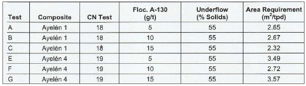
Filtration testwork, rheology and counter-current decantation tests were contracted out by G&T to Pocock Industrial Inc. of Utah. Pressure filtration tests showed that final moistures of approximately 15% can be achieved, and the counter-current decantation tests indicated a wash ratio of 3:1, indicating that three thickeners would be required in the plant design.
| 13.4 | Feasibility Study by BISA |
In November 2010 BISA proposed a process flowsheet of crushing, grinding, gravity (tabling) to recover free gold, recovery of gold from gravity tails by cyanide in agitation leach, with gold recovery from the pregnant solution through precipitation, and final on-site smelting to produce a gold doré.
Included with their assumptions is a project schedule starting with plant procurement, and then proceeding through construction and process commissioning with a project schedule spanning approximately 20 months, which includes preparation of the underground mine.
It is assumed by the author that this study was accompanied by a completed Environmental Impact Statement and used by Reliant to obtain the construction permit later granted. The indication from the site inspection is that Reliant was prepared to move forward in 2012 with the preparation of the construction camp, and prior to running into difficulties with the local communities.
| 13.5 | Conclusions |
It is quite clear to the QP that some of the testwork carried out is preliminary in nature and insufficient to support a Feasibility Study. Nevertheless, it has probably been sufficient to indicate:
| ● | “Heap leaching” is not a process option |
| ● | Production of high-grade bulk flotation concentrates is not an option unless there is a moratorium on cyanide use on this property |
| ● | Pre-concentration by gravity prior to a cyanide leach still requires further testwork to write off this as an option |
| ● | A cyanide leach is the obvious process route, although further testwork needs to be carried out for detailed engineering design purposes. |
If there is a moratorium on the use of cyanide, it should be noted that leaching with more environmentally accepted chemicals is coming into use (e.g. thiosulphate leaching).
| Technical Report on the San Luis Property | 101 |
This process is being promoted by SGS, and it removes gold from gold-bearing ores without the use of cyanide. Although not as aggressive a leaching agent as cyanide, thiosulphate offers several technological advantages including its lower toxicity and greater efficiency with gold deposits associated with preg-robbing ores. The thiosulphate leaching process, followed by resin-in-pulp gold extraction, has been developed by SGS to the point where it is a technically and economically viable alternative to cyanidation for some gold-bearing orebodies.
Draslovka Industries is promoting Glycene Leaching Technology as an alternative to cyanidation. They utilize Glycene, a non-toxic amino acid often used as a food additive or nutritional supplement in humans and animals.
Outotec (2019) has funded research at the Aalto University, Finland, into cyanide-free gold leaching in exceptionally mild chloride solutions.
Further advice on alternative leaching options is therefore recommended.
The samples used for metallurgical testing are thought to be representative of the types and styles of mineralization and the mineral deposit as a whole, although variability is yet to be tested. Except as set out herein, there are no currently known processing factors or deleterious elements that could have a significant effect on potential economic extraction.
| Technical Report on the San Luis Property | 102 |
| 14 | MINERAL RESOURCE ESTIMATES |
Reliant carried out the following Measured and Indicated Mineral Resource estimates as they grew the San Luis Project; in both cases, the Inferred estimates were minimal and are not shown in the following two summaries:
| ● | 2007 – Preliminary Measured and Indicated estimate totalling a contained 265,000 ounces of gold and 7,126,000 ounces of silver when applying a cut-off of 40 g/t Ag. |
| ● | 2008 – Second Measured and Indicated estimate totalling a contained 366,100 ounces of gold and 9,868,000 ounces of silver when applying the same cut-off. |
The second Measured and Indicated estimate was revised by Resource Modeling Inc. (“RMI”) in January 2009 and totalled a contained 348,100 ounces of gold and 9,003,300 ounces of silver when applying a 6.0 g/t Au cut-off. This estimate was then taken into the Feasibility Study carried out in 2010 (Table 14-1). It is a review of this last estimate together with the geological model and supporting data that comprises the objective of this current Technical Report.
| Table 14-1 | 2009 Reliant-declared Mineral Resource estimate (6.0 g/t Au cut-off) |
| Reliant’s declared Mineral Resource estimate for the San Luis Project, 2010 | |||||
| Resource Category | Tonnes | Au (g/t) |
Ag (g/t) |
Contained ounces | |
| Au | Ag | ||||
| Measured | 55,222 | 34.3 | 758 | 61,000 | 1,345,000 |
| Indicated | 429,183 | 20.8 | 555 | 287,000 | 7,658,200 |
| Measured + Indicated | 484,405 | 22.3 | 578 | 348,000 | G,003,200 |
| Inferred | 20,528 | 5.7 | 273 | 3,600 | 174,900 |
| 14.1 | Review of the 2009 Mineral Resource Estimate |
Review of the 2009 estimate comprises the principal objective of this current report. This has included the site visit for the purpose of checking drillhole locations and surface trenching, checking drill core and selected intersections, as well as the exploration facilities and the competent support of the Reliant geological team.
| 14.1.1 | Databases |
There are two main Microsoft Excel databases, one for the 2005–2006 surface trenching, and a second database for the 2006–2007 drilling. Table 14-2 and Table 14-3 summarize the trench and diamond drilling metres and samples assayed.
| Table 14-2 | Summary of trench sampling and metres assayed |
| Vein | Number | Metres | Assayed metres |
| Ayelén and HW Vein | 34 | 506 | 506 |
| Inés | 62 | 441 | 440 |
| Total | G6 | G47 | G46 |
Of the 161 drillholes completed within Reliant’s property to date, 136 drillholes targeted the Ayelén and Inés veins; that is 108 and 28 drillholes respectively.
| Technical Report on the San Luis Property | 103 |
| Table 14-3 | Summary of diamond drillholes and metres sampled and assayed |
| Vein | Number | Metres | Assayed metres |
| Ayelén and HW Vein | 108 | 19,196 | 3,655 |
| Inés | 28 | 3,158 | 546 |
| Total | 136 | 22,354 | 4,201 |
Diamond core recovery for the various drill campaigns was excellent. Fifty-six percent of the assayed intervals reportedly had a core recovery of 100%, and 95% of the remaining data had core recoveries in excess of 90%. For the minor amount of drilling where core recovery was below 50%, gold and silver grades tended to be lower than the grades in intervals having higher recovery.
Drill core information includes logged lithological codes as well as sample assay determinations for gold and silver. A significant number of drillhole intervals were not sampled and assayed when there was no evidence of mineralization within the cores. Vein intervals from seven twin holes drilled for metallurgical comminution testwork were not assayed and were excluded from the Mineral Resource estimate for this reason.
| Figure 14-1 | shows the drillholes that cut the Ayelén vein at depth along its strike together with the surface trench samples. |
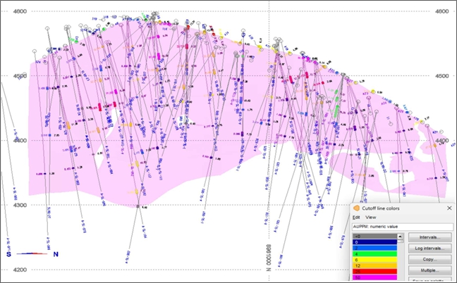
| Figure 14-1 | South-north section of the drillhole intersections along the Ayelén vein |
| Technical Report on the San Luis Property | 104 |
| 14.1.2 | Drill Core vs Chip-Channel Sampling Quality |
Majority of the sampled metres being used to estimate Mineral Resources have been derived from HQ diamond drillholes (87.75%) and the remainder obtained from chip-channel samples collected from “trenches” spaced along the outcropping veins. It had already been observed from the site inspection that there was a variation on quality between the trench and diamond drill core sampling.
RMI (2009) previously reviewed the two data types because of an apparent disparity between the mean grades of the two sampling methods when all data was compared. They noted that the trench samples had a higher mean grade than the diamond core holes.
To examine this apparent bias, RMI spatially paired the trench samples with the closest HQ drillhole samples so that various statistics could be calculated. Both sample types were composited after the raw assay data had been capped, and a total of 145 Ayelén trench composites were paired with the core holes. The resultant data summarized in Table 14-4 shows that the gold and silver core samples are about 10% higher than the chip-channel samples which suggests that the core samples are producing higher grades than the chip-channel samples.
| Table 14-4 | Paired core vs chip-channel sample grades |
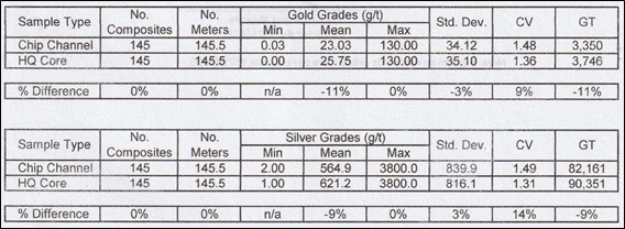
Source: RMI
The QP concludes that variance relates in part to chip-channel samples being taken to different geological boundaries to those cored in depth, partly due to the difficulty of taking trench samples within very hard rock vein boundaries. Therefore, better trench sampling or shallow drilling should probably be carried out in order to improve grade estimation. In the meantime, care needs to be taken when taking the chip-channel samples into account when it comes to Mineral Resource classification.
| 14.2 | Geological Domains and Modelling |
Geological modelling has considered the following three vein structures:
| ● | The Ayelén vein comprises the main structure and can be followed from surface trenches and drilling over a north-northwest trending strike length of over 600 m and dipping steeply to the west-southwest. The structure has been identified in depth down to a maximum of 270 m below surface in drillhole A-SL-104 on the southern part of the structure. Gold and silver grades are highest at surface, diminishing in depth. High-grade shoots are observed to plunge to the south. True widths are mostly between 2.0 m and 5.0 m, averaging 3.5 m, but have been noted to reach close to 15.0 m in trenches A10, A11 and A12, and drillhole SL06-17. |
| Technical Report on the San Luis Property | 105 |
| ● | The Ayelén HW vein parallels and is situated some 10 m to the west of Ayelén in the northern part. The main mineralized shoot extends over approximately 100 m in depth and along strike. True widths are estimated mostly between 1.5 m and 4.0 m, averaging 3.3 m. |
| ● | The Inés vein crops out some 100 m to the east of the Ayelén vein system and has been identified from surface trenches over a strike length of 250 m. The structure dips 65° to the east-northeast and has been followed by drilling to a depth of 100 m below surface. True widths are mostly between 1.0 m and 5.0 m, and average 2.5 m. |
Initial vein intercepts for the three modelled veins were taken from the historical work performed as part of the 2009 geological modelling, where intervals had been defined based on a nominal cut-off grade of 0.5 g/t Au as well as the drillhole logging. The intercepts were reviewed and, where necessary, modified to ensure consistent 3D vein structures. In addition, high-grade and low-grade sub-domains were differentiated within each structure considering lithology, gold grades and a minimum sample length interval inside vein envelopes of 2 m. The final defined intercepts and sub-domains are included in Appendix B.
3D vein and sub-domain wireframes were developed in Leapfrog Geo using implicit modelling techniques. The resulting vein models are pictured in Figure 14-2 and Figure 14-3.
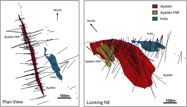
| Figure 14-2 | 3D wireframe models including Ayelén, Ayelén HW and Inés |
| Technical Report on the San Luis Property | 106 |
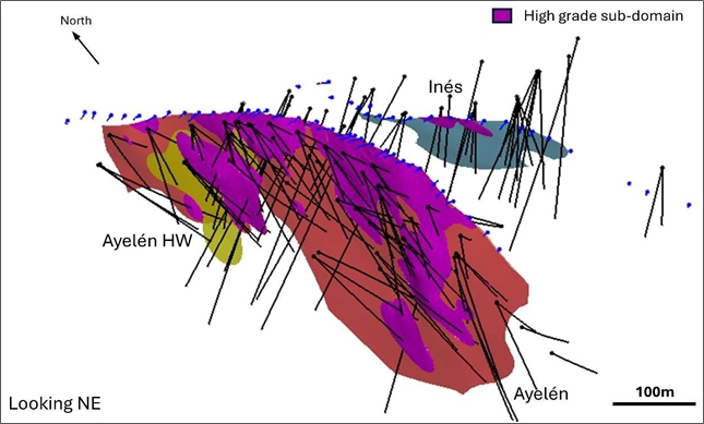
| Figure 14-3 | 3D wireframe models showing high-grade domains |
Modelled vein/wall-rock contacts are noted not to always recognize true geological boundaries. In some cases, the edge of vein sample continues into the wall-rock, in other cases the edge of the model is within the vein in order to capture grade without including low-grade vein rock.
There is therefore a need to revise and improve the geological model prior to conversion to mineable reserves.
The distribution of gold and silver grades along the Ayelén vein is shown in Figure 14-4, the widths in Figure 14-5 (left) and the widths x AuEq in Figure 14-5 (right).
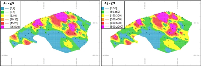
| Figure 14-4 | Ayelén vein – distribution of gold grades (left) and distribution of silver grades (right) |
| Technical Report on the San Luis Property | 107 |
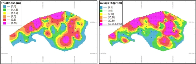
| Figure 14-5 | Ayelén vein – distribution of true widths (left) and distribution of width x AuEq grades (right) |
| 14.3 | Outlier Treatment |
High outlier gold and silver values for each vein were reviewed using log-probability plots shown in Figure 14-6 and Figure 14-7, where departures from log-normality are noted by inflections at the high end of the distributions. The chosen outlier thresholds correspond to approximately the 95th percentile of the distributions and these values were used to cap high grade values prior to using these in the grade estimation process.
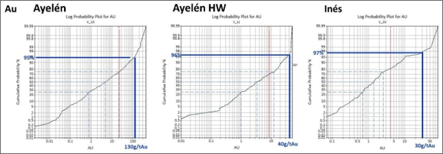
| Figure 14-6 | Gold log-probability plots for vein samples showing the determined capping values |
| Technical Report on the San Luis Property | 108 |
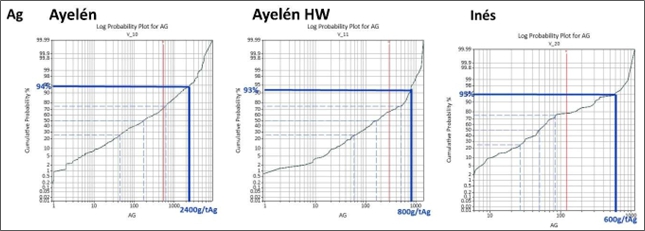
| Figure 14-7 | Silver log-probability plots for vein samples showing the determined capping values |
| 14.4 | Sample Lengths |
A total of 808 samples inside the vein envelopes were sampled at intervals averaging close to 1 m. Figure 14-8 shows the sample interval ranges. The varying sample lengths were composited into 1 m lengths after outlier treatment (top cutting) was applied due to the high nugget effect seen within the sample results.
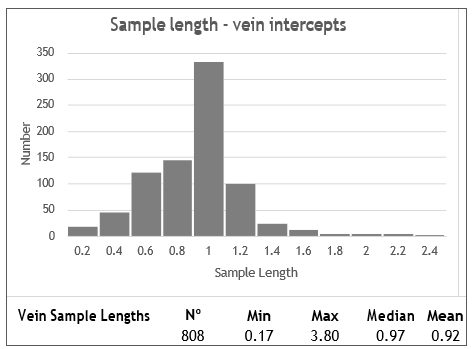
| Figure 14-8 | Histogram of sample interval lengths inside vein intercepts |
| 14.5 | Block Model Parameters |
The block model for the San Luis vein structures was developed using a 1 m(X) by 5 m(Y) by 5 m(Z) parent block size with sub-celling at boundaries to represent more precisely the geometry of the modelled structures. The block model parameters and extent are summarized in Table 14-5.
| Technical Report on the San Luis Property | 109 |
| Table 14-5 | Block model parameters |
| Origin | No. of blocks | Size (m) | ||
| Parent | Sub-cell | |||
| Easting (X) | 190,000 | 1,000 | 1 | 0.20 |
| Northing (N) | 8,960,500 | 200 | 5 | 1.00 |
| Elevation (Z) | 4,200 | 90 | 5 | 0.50 |
Capped gold and silver samples within the vein envelopes and domains were composited to regular 1 m intervals. These were used to interpolate gold and silver grades into individual blocks using inverse distance squared interpolation. Blocks were estimated in three search passes oriented parallel to the axis of the vein structure along observed direction of continuity. Table 14-6 shows the search strategy employed.
| Table 14-6 | Search parameters used in block interpolation |
| Distance (m) | Rotation | No. of composites | ||||
| X | Y | Z | Axis (X) | Minimum | Maximum | Maximum/hole |
| 20 | 60 | 30 | -35°S | 4 | 12 | 3 |
| 40 | 120 | 60 | -35°S | 4 | 12 | 3 |
| 60 | 180 | 90 | -35°S | 1 | 12 | 3 |
| 14.6 | Gold and Silver Grade Estimation |
Figure 14-9 and Figure 14-10 show box plots representing gold and silver distributions for the different veins. This is complemented by gold and silver histograms including all veins samples shown in Figure 14-11 and Figure 14-12. High-grade and low-grade domains show very different distributions confirming distinctive domains within the vein structures.
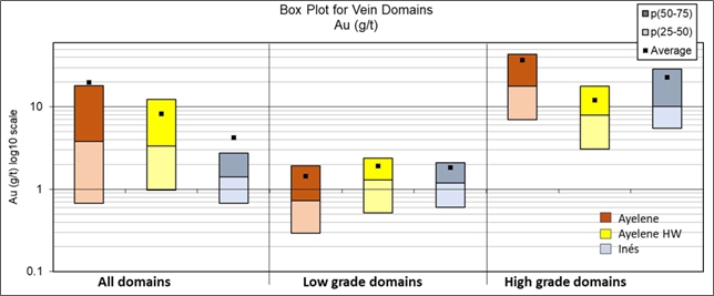
| Figure 14-9 | Box plot for gold for vein samples within different domains |
| Technical Report on the San Luis Property | 110 |
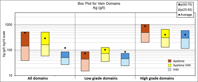
| Figure 14-10 | Box plot for silver for vein samples within different domains |
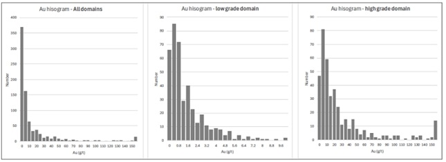
| Figure 14-11 | Gold histogram for different domains – all veins |
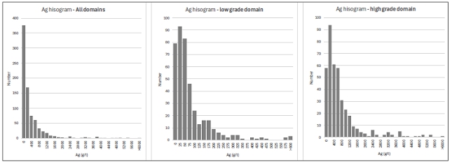
| Figure 14-12 | Silver histogram for different domains – all veins |
| Technical Report on the San Luis Property | 111 |
Statistics for gold and silver raw and capped values are detailed in Table 14-7 and Table 14-8. Notable observations are:
| ● | The effect of capping outlier values is significant, reducing overall gold grades by 12% and silver grades by 14% in the Ayelén vein. |
| ● | Coefficients of variation (CVs) are significantly reduced to values just over 1 after domaining and capping. This gives additional support to distinctive units within the vein envelopes. |
| Table 14-7 | Sample statistics for gold, before and after capping |
| Au (g/t) | All | Low-grade domain | High-grade domain | ||||||
| Ayelén | Aye-HW | Inés | Ayelén | Aye-HW | Inés | Ayelén | Aye-HW | Inés | |
| Raw data | |||||||||
| Count | 576 | 145 | 87 | 279 | 55 | 77 | 297 | 90 | 10 |
| Minimum | 0.0 | 0.0 | 0.1 | 0.0 | 0.0 | 0.1 | 0.2 | 0.1 | 1.9 |
| Maximum | 434 | 50 | 83 | 12 | 17 | 9 | 434 | 50 | 83 |
| Mean | 19.8 | 8.2 | 4.2 | 1.4 | 1.9 | 1.8 | 37.0 | 12.1 | 22.8 |
| SD | 42.5 | 10.6 | 11.0 | 1.7 | 2.6 | 2.0 | 53.7 | 11.8 | 26.3 |
| CV | 2.1 | 1.3 | 2.6 | 1.2 | 1.4 | 1.1 | 1.5 | 1.0 | 1.2 |
| Capped data | |||||||||
| Count | 576 | 145 | 87 | 279 | 55 | 77 | 297 | 90 | 10 |
| Minimum | 0.0 | 0.0 | 0.1 | 0.0 | 0.0 | 0.1 | 0.2 | 0.1 | 1.9 |
| Maximum | 130 | 40 | 30 | 12 | 17 | 9 | 130 | 40 | 30 |
| Mean | 17.5 | 8.1 | 3.4 | 1.4 | 1.9 | 1.8 | 32.5 | 11.8 | 15.2 |
| SD | 31.2 | 10.0 | 6.1 | 1.7 | 2.6 | 2.0 | 37.7 | 11.0 | 11.9 |
| CV | 1.8 | 1.2 | 1.8 | 1.2 | 1.4 | 1.1 | 1.2 | 0.9 | 0.8 |
| Difference 2-1 (%) | -12% | -2% | -21% | 0% | 1% | 0% | -12% | -2% | -33% |
| Table 14-8 | Sample statistics for silver, before and after capping |
| Ag (g/t) | All | Low-grade domain | High-grade domain | ||||||
| Ayelén | Aye-HW | Inés | Ayelén | Aye-HW | Inés | Ayelén | Aye-HW | Inés | |
| Raw data | |||||||||
| Count | 576 | 146 | 87 | 279 | 55 | 77 | 297 | 90 | 10 |
| Minimum | 0.0 | 0.0 | 5.9 | 0.0 | 0.0 | 5.9 | 2.0 | 6.0 | 40.0 |
| Maximum | 8,910 | 1,405 | 1,115 | 571 | 662 | 897 | 8,910 | 1,405 | 1,115 |
| Mean | 487 | 294 | 123 | 73 | 104 | 85 | 876 | 407 | 409 |
| SD | 912 | 304 | 203 | 93 | 114 | 140 | 1137 | 326 | 353 |
| CV | 1.9 | 1.0 | 1.7 | 1.3 | 1.1 | 1.6 | 1.3 | 0.8 | 0.9 |
| Capped data | |||||||||
| Count | 576 | 145 | 87 | 279 | 55 | 77 | 297 | 90 | 10 |
| Minimum | 0.0 | 0.9 | 5.9 | 0.0 | 0.9 | 5.9 | 2.0 | 6.0 | 40.0 |
| Maximum | 2,400 | 800 | 600 | 571 | 662 | 600 | 2,400 | 800 | 600 |
| Mean | 419 | 277 | 110 | 73 | 104 | 80 | 743 | 383 | 340 |
| SD | 617 | 268 | 155 | 93 | 114 | 113 | 717 | 280 | 240 |
| CV | 1.5 | 1.0 | 1.4 | 1.3 | 1.1 | 1.4 | 1.0 | 0.7 | 0.7 |
| Difference 2-1 (%) | -14% | -6% | -10% | 0% | 0% | -6% | -15% | -6% | -17% |
| Technical Report on the San Luis Property | 112 |
| 14.7 | Bulk Density |
A total of 610 specific gravity measurements for drilling at Ayelén were taken from drill core from 121 of the 136 drillholes covering different lithotypes. The determinations were made by taking the average of weighing the sample in air five times (each time after being dried in an oven to remove moisture), followed by the average of five measurements of the core sample length and the average of the five measurements. Table 14-9 summarizes the determinations by lithotype.
| Table 14-9 | Specific gravity measurements in the Ayelén zone |
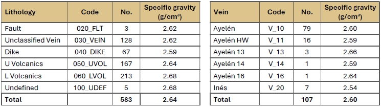
An average value of 2.60 g/cm3 obtained from these measurements within the vein envelopes was considered reasonably representative for the resource estimation.
| 14.8 | Resource Classification |
Under CIM Definition Standards, Mineral Resources are classified into three confidence categories. In order of increasing confidence, blocks can be classified as either Inferred, Indicated or Measured. Important considerations in assigning a resource category are spatial aspects, including continuity of grade, and the locations, types, and spatial density of the informing data. In addition, it is important to consider the relative confidence of all the data inputs.
The Mineral Resources for the San Luis veins were classified into Indicated and Inferred categories based on vein intercept spacings. Whilst closer spaced sample information is found at surface from surface trenches at distances of 10–25 m, the sampling of these is considered of inferior quality to the drillholes and further work is required to address relative precision of these samples. As such, at this point, a Measured Resource has not been defined. Blocks estimated at intercept spacings of 50 m or less were classified as Indicated, otherwise they were classified as Inferred.
| Technical Report on the San Luis Property | 113 |
Figure 14-13 shows long section projections for the Ayelén vein, Ayelén HW vein and the Inés, showing the outlined Mineral Resource classification.
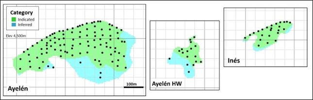
Figure 14-13 East-facing long sections of Ayelén, Ayelén HW and Inés showing Mineral Resource categories, surface trench and drillhole intercept spacing
| 14.9 | Block Model Validation |
An essential step in resource modelling is the verification process. Statistics, swath plots (spatial averages) and visual checks comparing the block estimates to the informing data are presented in the following sections.
| 14.9.1 | Statistics |
The 1 m composites are compared to the block estimates in Table 14-10. The results show lower average block grades as compared to the sample composites as a result of capping and sample clustering in high-grade areas. Overall, the comparison is considered good.
| Technical Report on the San Luis Property | 114 |
| Table 14-10 | Statistics comparing 1 m composite samples to Resource Model block grades |
| Vein | Field | Domain | 1 m Composites | Resource Model | % Difference mean | ||||||||||||
| No. | Min. | Max. | Mean | Capped | SD | CV | Kt | Min. | Max. | Mean | SD | CV | Capped | Raw | |||
|
Ayelén |
Au |
Low High |
270 280 |
0.0 0.0 |
12 130 |
1.4 33.1 |
1.4 37.3 |
1.6 35.4 |
1.1 1.1 |
467 308 |
0.0 3.7 |
7 126 |
1.3 33.1 |
0.9 26.3 |
0.7 0.8 |
-10% 0% |
-10% -11% |
| Ag |
Low High |
270 280 |
0 2 |
550 2,400 |
73 737 |
73 864 |
88 665 |
1.2 0.9 |
467 308 |
0 45 |
406 2,369 |
64 745 |
44 481 |
0.7 0.6 |
-13% 1% |
-13% -14% | |
|
Ayelén HW |
Au |
Low High |
49 73 |
0.0 0.5 |
7 38 |
1.7 11.0 |
1.7 11.2 |
1.5 8.7 |
0.9 0.8 |
65 65 |
0.0 2.8 |
4 30 |
1.4 10.9 |
0.6 4.0 |
0.5 0.4 |
-19% 0% |
-19% -2% |
| Ag |
Low High |
49 73 |
0 15 |
353 800 |
94 365 |
94 384 |
77 229 |
0.8 0.6 |
65 65 |
2 122 |
259 725 |
79 374 |
46 118 |
0.6 0.3 |
-16% 2% |
-16% -3% | |
|
Inés |
Au |
Low High |
70 11 |
0.1 2.5 |
7 30 |
1.7 16.5 |
1.7 23.5 |
1.5 10.4 |
0.9 0.6 |
91 7 |
0.3 6.5 |
5 29 |
1.5 15.4 |
0.8 6.3 |
0.5 0.4 |
-12% -7% |
-12% -35% |
| Ag |
Low High |
70 11 |
6 59 |
524 600 |
75 364 |
78 442 |
91 218 |
1.2 0.6 |
91 7 |
10 88 |
409 594 |
84 338 |
69 144 |
0.8 0.4 |
12% -7% |
7% -24% | |
| Technical Report on the San Luis Property | 115 |
| 14.9.2 | Swath Plots |
Swath plots are commonly used to compare block estimates to sample averages within coordinate slices oriented in specific directions. Observed differences may be suggestive of extrapolation or over-smoothing of the block estimates. Larger differences can often be attributed to areas with limited sampling or sample clustering.
Gold and silver swath plots for Ayelén, Ayelén HW and Inés for high-grade and low-grade domains along northing and elevation axes are included in Figure 14-14 and Figure 14-. Overall comparisons are considered good with differences that can be more significant over slices comparing limited data and vein volumes. Moreover, there is no indication of biases, extrapolation, or over-smoothing of the block estimates.
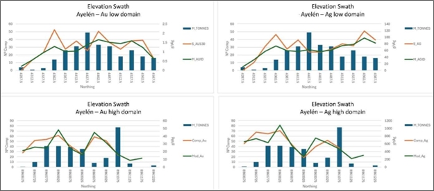
| Figure 14-14 | Ayelén vein gold – elevation and northing swath plots for different domains |
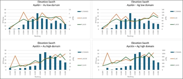
| Figure 14-15 | Ayelén vein silver – elevation and northing swath plots for different domains |
| Technical Report on the San Luis Property | 116 |
| 14.9.3 | Estimation Software Checks |
An estimation check was made using Minesight software. The variation in overall tonnes and the equivalent-gold (AuEq) ounces contained was negligible.
| 14.9.4 | Visual Checks |
The final step in the verification process was to visually review long sections comparing full width block-estimated values against the drillhole composite assays. Figure 14-15 and Figure 14-16 show east-facing long sections through each of the vein models comparing composite silver and gold grades to full width block-estimated grades, noting a good correlation.
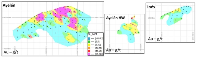
| Figure 14-16 | Gold – full width comparison between vein intercepts and block model |
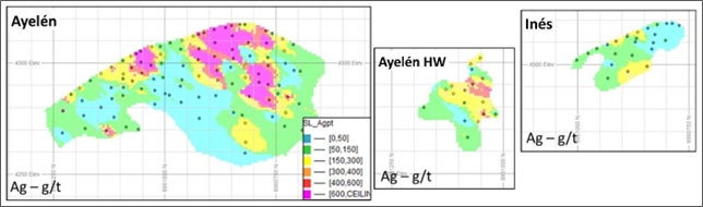
| Figure 14-17 | Silver – full width comparison between vein intercepts and block model |
| 14.10 | Reasonable Prospects for Economic Extraction |
Reasonable prospects for eventual economic extraction assume underground mining using an overhand cut-and fill method of stope extraction, with the last cut being long-holed and backfilled from surface, and with the following assumptions: metal prices of Au and Ag prices of US$1,700 and US$20 respectively; mining cost of US$85 per tonne, processing cost of US$70 per tonne and general and administrative costs of US$45 per tonne (consistent with current Peruvian underground mines); and Au and Ag recoveries of 90% and 75% respectively from cyanide leaching.
| Technical Report on the San Luis Property | 117 |
| 14.11 | Mineral Resource Statement |
The Mineral Resources for the San Luis veins are summarized in the following Table 14-11.
| Table 14-11 | San Luis Project Mineral Resources estimated in 2025 |
| San Luis Project Mineral Resources | ||||||
| Vein | Resource Category | Tonnes | Grade (g/t) | Contained ounces | ||
| Au | Ag | Au | Ag | |||
| Ayelén | 353,602 | 28.83 | 655.2 | 327,798 | 7,448,012 | |
|
Ayelén HW Inés |
Indicated |
72,462 27,720 |
9.94 5.93 |
348.0 209.8 |
23,163 5,282 |
810,798 186,999 |
| Subtotal | 453,784 | 24.42 | 578.G | 356,243 | 8,445,80G | |
| Ayelén | 41,911 | 5.39 | 208.3 | 7,260 | 280,725 | |
|
Ayelén HW Inés |
Inferred |
6,511 3,280 |
3.18 2.31 |
170.9 185.9 |
666 244 |
35,770 19,598 |
| Subtotal | 51,702 | 4.G2 | 202.2 | 8,170 | 336,0G3 | |
Notes:
| ● | Mineral Resources are not Mineral Reserves and do not have demonstrated viability. | |
| ● | All tonnages reported are Dry Metric Tonnes, and contained gold and silver are reported in Troy Ounces. | |
| ● | Mineral Resources are estimated at a cut-off grade of 3 g/t AuEq that considers bullion prices of US$1,700/oz gold and US$20/oz silver, and process recoveries of 90% for both gold and silver. | |
| ● | The AuEq content has been calculated as follows: AuEq = Au+0.0117C47*Ag.Numbers in the above table have not been rounded to ensure consistency in calculations and summations. However, readers should consider that due to estimation uncertainty, the report numbers are not reliable beyond three significant figures for Indicated Resources, and two significant figures for Inferred Resources. | |
| ● | The mineral resource estimate has an effective date of January 15, 2025. |
The variance in gold and silver ounces between this estimate and that previously carried out for Reliant by MRI (2009) is as shown in Table 14-12.
| Table 14-12 | Summary comparison 2009 with this estimate of contained ounces |
| Resource class | 200G Contained ounces by MRI | 2025 estimated contained ounces | ||
| Au | Ag | Au | Ag | |
| Measured + Indicated | 348,000 | 9,003,200 | 356,243 | 8,445,809 |
| Inferred | 3,600 | 174,900 | 8,170 | 336,093 |
This variance relates to the exclusion of several minor branch veins (Table 14-13) where there is as yet insufficient supporting information to class these as containing Mineral Resources. In parallel, there is an increase in Inferred Resources due to a minor modification in classification limits.
| Technical Report on the San Luis Property | 118 |
| Table 14-13 | Summary by vein – comparison 2009 with this 2025 estimate |
Cut-off =>3 g/t AuEq |
Category |
Mineral
Resource estimate by RMI and REI for Reliant, 2009 |
Mineral
Resource estimate for HSC, 2025 | ||||
|
Tonnes |
Grade |
Tonnes |
Grade | ||||
| g/t Au | g/t Ag | g/t Au | g/t Ag | ||||
|
Ayelén
|
Measured
Indicated
|
55,222
308,070
|
34.3
25.5
|
758
623
|
0
353,602
|
0
28.83
|
0
655.2
|
| Measured + Indicated | 363,292 | 26.8 | 643 | 353,602 | 28.82 | 655.2 | |
| Inferred | 4,741 | 7.9 | 261 | 51,702 | 4.92 | 202.2 | |
Ayelén HW
|
Measured
Indicated
|
90,661
|
9
|
382
|
0
72,462
|
0
9.94
|
0
348.0
|
| Measured + Indicated | 90,661 | 9 | 392 | 72,462 | 9.94 | 348.0 | |
| Inferred | 382 | 11.4 | 439 | 6,511 | 3.18 | 170.9 | |
Inés
|
Measured
Indicated
|
15,344
|
8.5
|
294
|
0
27,720
|
0
5.93
|
0
209.8
|
| Measured + Indicated | 15,344 | 8.5 | 294 | 27,720 | 5.93 | 209.8 | |
| Inferred | 14,828 | 4.7 | 268 | 3,280 | 2.31 | 185.9 | |
Branch (12)
|
Measured
Indicated
|
765
|
5
|
185
|
0
0
|
0
0
|
0
0
|
| Measured + Indicated | 765 | 5 | 185 | 0 | 0 | 0 | |
| Inferred | 0 | 0 | 0 | ||||
Branch (13)
|
Measured
Indicated
|
11,166
|
8
|
378
|
0
0
|
0
0
|
0
0
|
| Measured + Indicated | 11,166 | 8 | 378 | 0 | 0 | 0 | |
| Inferred | 195 | 5.7 | 301 | 0 | 0 | 0 | |
Branch (14)
|
Measured
Indicated
|
1,224
|
9.9
|
454
|
0
0
|
0
0
|
0
0
|
| Measured + Indicated | 1,224 | 9.9 | 454 | 0 | 0 | 0 | |
| Inferred | 0 | 0 | 0 | ||||
|
Branch (15)
|
Measured
Indicated
|
1,746
|
13.8
|
739
|
0
0
|
0
0
|
0
0
|
| Measured + Indicated | 1,746 | 13.8 | 739 | 0 | 0 | 0 | |
| Inferred | 382 | 11.4 | 439 | 0 | 0 | 0 | |
Branch (16)
|
Measured
Indicated
|
207
|
6.5
|
145
|
0
0
|
0
0
|
0
0
|
| Measured + Indicated | 207 | 6.5 | 145 | 0 | 0 | 0 | |
| Inferred | 0 | 0 | 0 | ||||
| Technical Report on the San Luis Property | 119 |
Subtotals
|
Measured
Indicated |
55,222
429,183 |
34.3
20.8 |
758
555 |
0
453,784 |
0
24.42 |
0
578.9 |
| Measured + Indicated | 484,405 | 22.3 | 578 | 453,784 | 24.42 | 578.9 | |
| Inferred | 20,528 | 5.7 | 273 | 51,702 | 4.92 | 202.2 |
It is important to note, that the distribution of the Indicated Resources which comprises 96% of the resource tonnage, shows that 82.4% of the mineral value estimated to date occurs within 100 metres of surface.
Table 14-14:
| ELEVATION | Tonnes | Grade (g/t) | Contained Ounces | Tonnes | ||
| Au | Ag | Au | Ag | |||
| 4500 - 4585 | 167,927 | 37.29 | 791.5 | 201,348 | 4,273,421 | 55.20% |
| 4450 - 4495 | 128,631 | 23.52 | 551.9 | 97,275 | 2,282,322 | 27.20% |
| 4400 - 4445 | 115,758 | 12.85 | 414.4 | 47,835 | 1,542,267 | 14.50% |
| 4350 - 4395 | 39,293 | 6.95 | 252.5 | 8,779 | 319,019 | 2.80% |
| 4330 - 4345 | 2,276 | 13.91 | 402.0 | 1,018 | 29,417 | 0.30% |
| TOTAL | 453,784 | 24.42 | 578.9 | 356,256 | 8,446,496 | 100.00% |
Summary of the Indicated Resources by Elevation
This current review of the property mineral resources is in general agreement with the 2009 historical estimate, the only variations comprising the following:
| ● | Elimination of five minor branch veins due to limited data |
| ● | The downgrading of limited Measured Resources to the Indicated category due to the poorer quality of surface sampling compared with drillhole sampling. |
Except as disclosed elsewhere herein, the author is not aware of any environmental, permitting, legal, title, taxation, socio-economic, marketing, political or other relevant factors that could materially affect the mineral resource estimate disclosed herein.
| Technical Report on the San Luis Property | 120 |
| 15 | MINERAL RESERVE ESTIMATES |
This section is not applicable as the San Luis Property is not an “advanced property” as defined in NI 43- 101.
| Technical Report on the San Luis Property | 121 |
| 16 | MINING METHODS |
This section is not applicable as the San Luis Property is not an “advanced property” as defined in NI 43- 101.
| Technical Report on the San Luis Property | 122 |
| 17 | RECOVERY METHODS |
This section is not applicable as the San Luis Property is not an “advanced property” as defined in NI 43- 101.
| Technical Report on the San Luis Property | 123 |
| 18 | PROJECT INFRASTRUCTURE |
This section is not applicable as the San Luis Property is not an “advanced property” as defined in NI 43- 101.
| Technical Report on the San Luis Property | 124 |
| 19 | MARKET STUDIES AND CONTRACTS |
This section is not applicable as the San Luis Property is not an “advanced property” as defined in NI 43- 101.
| Technical Report on the San Luis Property | 125 |
| 20 | ENVIRONMENTAL STUDIES, PERMITTING AND SOCIAL OR COMMUNITY IMPACT |
This section is not applicable as the San Luis Property is not an “advanced property” as defined in NI 43- 101.
| Technical Report on the San Luis Property | 126 |
| 21 | CAPITAL AND OPERATING COSTS |
This section is not applicable as the San Luis Property is not an “advanced property” as defined in NI 43- 101.
| Technical Report on the San Luis Property | 127 |
| 22 | ECONOMIC ANALYSIS |
This section is not applicable as the San Luis Property is not an “advanced property” as defined in NI 43- 101.
| Technical Report on the San Luis Property | 128 |
| 23 | ADJACENT PROPERTIES |
Item 23 permits a technical to include relevant information concerning an adjacent property. It was determined not to include information regarding adjacent properties in this technical report.
| Technical Report on the San Luis Property | 129 |
| 24 | OTHER RELEVANT DATA AND INFORMATION |
The author notes that following the rapid advancement of the San Luis Property from exploration (2005– 2007), and resource estimation (2008–2009), the project then proceeded into a Feasibility Study (2010) without going through the process of scoping the project with a Preliminary Economic Assessment or considering all the engineering trade-offs needed to support a Prefeasibility Study beforehand.
SSR Mining may have recognized certain areas of weakness in their project planning when they requested Stantec to carry out a review and “gap analysis” in November 2010. Their report highlighted the need for flexible thinking, trade-off studies and design alternatives, and the QP notes the preliminary nature of the metallurgical testing and that further testing will be required before moving forward into detailed engineering.
As exploration moves forward it is therefore important to recognize that in addition to improving the geological modeling and supporting data, it will be important to develop geotechnical (RQD, RMR and UCS data) and geo-metallurgical (mapping and testing variability) models in order to optimise this type of mineralization for mine planning purposes.
| Technical Report on the San Luis Property | 130 |
| 25 | INTERPRETATION AND CONCLUSIONS |
This Technical Report represents a review and update of the “Updated Mineral Resource Estimate San Luis Project, Ancash Department, Perú” prepared by Resource Modeling Incorporated and Resource Evaluation Incorporated and dated January 9, 2009 (the “Historical Resource Estimate” or “2009 Mineral Resource Estimate”).
| 25.1 | Geological Model and Supporting Data |
Whilst the geological model and supporting data are considered adequate for Mineral Resource estimation it has been noted that some improvements need to be made to assist mine planning prior to converting Mineral Resources to Mineral Reserves in a potential update to “San Luis Project Feasibility Study, Ancash Department, Peru” dated June 2010” (the “Historical Feasibility Study”).
Any new geological team needs to acquaint themselves with all drill-core intersections and, where necessary, re-interpret geological boundaries and related grade information, carry out sampling to add to grade boundary information, and most importantly, to carry out more detailed geotechnical logging using the core photographs for the purposes of creating a geotechnical model for mine planning purposes.
| 25.2 | Mineral Resource Estimation |
The current Mineral Resource Estimate and supporting information for the Ayelén vein are in general agreement with the Historical Resource Estimate. See Table 14-11 in Item 14.
A few minor weaknesses were noted in supporting data and the geological modelling, and further drilling will be required to upgrade Indicated Resources to Measured Resources prior to mine planning and conversion to Mineral Reserves in any potential update to the Historical Feasibility Study.
| 25.3 | Exploration Objectives |
The exploration objectives are clear and require more exploration to grow the current Mineral Resources and make new discoveries that could support further growth beyond this, with the priorities as follows:
| 1) | Continue with property-wide exploration for additional gold-silver bearing veins, including in the southeast catchment that has returned highly anomolous stream sediment samples but not been prospected or mapped. |
| 2) | Continue drilling in the Bonita vein to test the strike and depth extent of mineralization beyond the single section currently tested by drilling and also advance prospecting, mapping and sampling in the Bonita area to identify new veins and follow-up with trenching to support drill-testing these veins. |
| 25.4 | Project Development |
It is the observation of the current writer that the current objectives of the exploration team are supported, although different project scales should be assessed if and when significant additional mineral resources are added.
| Technical Report on the San Luis Property | 131 |
| 25.5 | Conclusions |
San Luis has the potential to be a highly profitable mine. The priority is to advance exploration alongside community social relations programs to support updated Mineral Resources, Feasibility Studies and permitting with social license to support development.
| Technical Report on the San Luis Property | 132 |
| 26 | RECOMMENDATIONS |
Due to the discovery of "bonanza grades" in the Ayelén, Inés and Bonita veins, along with the presence of known veins indicating high grades from surface sampling, as well as the potential for finding other vein systems in covered areas, and areas of potential identified by stream sediment sampling on the property, the San Luis project shows promise for hosting a relevant epithermal vein field that can generate positive economic returns at various project scales.
New exploration efforts would be best be focused on growing the mineral resources and discovering new veins as follows:
| 3) | Continue with property-wide exploration for additional gold-silver bearing veins, including in the southeast catchment that has returned highly anomalous stream sediment samples although these have not yet been prospected or mapped. |
| 4) | Continue drilling in the Bonita vein to test the strike and depth extent of mineralization beyond the single section currently tested by drilling and also, advance prospecting, mapping and sampling in the Bonita area to identify any other veins and follow-up with trenching to support drill-testing these veins. |
In view of the conclusions made in Item 25 of this report, the writer makes the following recommendations.
| 26.1 | Exploration |
It is recommended that the Company continues the current field work program to determine the potential of the known untested veins to the south of Ayelén and identification of new gold-silver bearing veins between Ayelén and the southern Bonita target. The early field component of this program should include initial prospecting/transversing, geochemical soil and rock sampling, and structural, lithological and alteration mapping.
Data integration of field results should provide a pipeline and prioritization of new targets for further trenching and drilling. Execution of the discovery phase drilling programs should materialize after the required permitting processes are put in place.
It is recommended that the Company proceed with the trench and drill sampling of the Bonita zone to the south of the Ayelén vein system. The first objective should be delineating the extent of any mineralized structures, and understanding the general controls upon mineralization.
Delineation drilling should follow new high priority targets according to target ranking on the discovery drilling phase. Success in this stage should trigger resource extension drilling in new targets and aiming at increasing the MRE.
| 26.2 | Geological Modelling and Resource Estimation |
The Company should complete mineral resource extension drilling in new veins outlined in the discovery/delineation phase.
The Company should conduct continuous review of all geological data over existing resource models (Ayelén and Ines) and potential new resources, after successful discovery/delineation phases (e.g. Bonita).
| Technical Report on the San Luis Property | 133 |
Some improvements need to be made to geological processes. Although QAQC is conducted, there is a need for regular batch and monthly analysis of results and reporting. Regular reporting of all other exploration results should also be considered as mandatory.
More complete geotechnical (RQD, RMR and UCS data) needs to be recovered together with geo-metallurgical data in order to develop geotechnical and geo-metallurgical variability models for each vein included in the MRE, as will be required when it comes to converting Mineral Resources into Mineral Reserves.
| 26.3 | Community and Social Engagement |
The property occupies community land and developing and growing the social license is a priority for the Company. The Company has an established presence on the property and community agreement to support commencing exploration. The author recommends that the Company employs its participatory development model based on community capacity building through skill and safety training, employment, entrepreneurship, infrastructure development and environmental, cultural, health and education programs, activities and budget.
| 26.4 | The Proposed Exploration Program |
A two-phase work program is proposed, with a total estimated cost of USD$10 million, which includes a 15% contingency. A summary of the program along with detailed cost estimates is provided in Table 26-1.
Phase 1 focuses on ground base discovery exploration work of Au/Ag veins to the south of Ayelén and in the area between Ayelén and Bonita, together with early delineation of resource potential in Bonita.
This phase is projected to require US$1.7 million and includes the following recommendations:
| ● | Executing fieldwork on known untested veins and new targets for precise evaluation and prioritization. |
| ● | Initiation of drilling at Bonita, targeting priority zones within the known strike extent of the vein system. |
The extent of Phase 2 is partially contingent upon favourable results from Phase 1. The estimated cost for this second phase is approximately US$8.3 million, which will cover:
| ● | Extensive diamond drilling for resource definition and extension in Bonita |
| ● | Initial discovery and resource outlining of new targets |
| Technical Report on the San Luis Property | 134 |
Table 26-1 – Recommended Work Program
| Phase/Area | Phase 1 | Phase 2 | ||
| Activity | Budget US$ | Activity | Budget US$ | |
| Bonita Vein | Mapping, Trenching & Discovery & Resource outline drilling (~2500 m) | 850,000 |
Resource drilling (~4000 m) |
1,300,000 |
| Ayelen South Trend Veins | Geochemistry, Geological Mapping, Geophysics | 300,000 |
Discovery and extensional drilling and initial resource outline (~8000 m)
|
3,250,000 |
| New Target Generation | Geochemistry, Geological Mapping, Geophysics | 150,000
|
Discovery drilling and initial Resource outline of top Priority targets (~6000 m)
|
2,000,000 |
| Community and Social Engagement/Permitting | Community programs and infrastructure development | 150,000
|
Community programs and infrastructure development | 700,000 |
| Sub Total | 1,450,000 |
7,250,000 | ||
| Contingency 15% | 217,500 | 1,087,500 | ||
| Total | 1,667,500 | 8,337,500 | ||
| Total USD $ | 10,005,000 | |||
| Technical Report on the San Luis Property | 135 |
| 27 | REFERENCES |
Arleón, J. (2009): “Chapter V: Study Mineral Processing of San Luis Project.” Feasibility Study for Ayelén Vein – San Luis Project.
Beane, R. E. and Titley, S. R., (1981): Porphyry Copper Deposits Part II. Hydrothermal Alteration and Mineralization; in 75th Anniversary Volume, Economic Geology, pages 235-269.
Benavides-Caceres, V., (1999): Orogenic Evolution of the Perúvian Andes; In Geology and Ore Deposits of the Central Andes, Society of Economic Geologists Special Publication Number 7, Skinner, B.J. (ed), pp 61 - 107.
BISA Engineers (April 2010): Feasibility Study, San Luis Project, Ancash Department, Peru.
BISA Laboratory (nd). Petrographic and Mineralogic Studies, with Mineralogic Analyses by X-ray Diffraction and Chemical Analyses by X-ray Fluorescence of Twenty-three Samples from the San Luis Project.
Blanchflower, J. D., (2007/08): NI 43-101 compliant Technical Report and First Mineral Resource estimate on the San Luis Project, Ancash Department, North Central Peru.
Burk, R., (2007): Various notes and photographs pertaining to the regional and property geology.
Cox, D. P. and Singer, D. A., 1988: Distribution of Gold in Porphyry Copper Deposits; U. S. Geological Survey, Open File 88-46, 23 pages.
Canadian Environmental & Metallurgical Inc. (November 2009): Static and Kinetic Test Report for Silver Standard Resources, San Luis Project, Perú.
Cox DP, Singer DA (1988) Distribution of gold in porphyry copper deposits, U.S. Geological Survey Open File Report pp. 88-46.
Drobek, P., (May, 2012): Internal Memorandum with Recommendations for an 8 hole drilling program totalling 4,300 metres aimed at starting exploration within the DB Zone.
Ferraris, F., (2007): Pucajirca Hydrothermal Altered Zone, Ancash Department, Central Peru; private technical report prepared for Esperanza Silver Corporation and Silver Standard Resources Inc., pp 37 plus appendices and maps.
Folinsbee, J. & Shouldice. (July 14, 2009): Grindability Testing, San Luis Project, Central Peru, South America KM2453. G&T Metallurgical Services Ltd.
Folinsbee, J. & Shouldice. (July 16, 2009): Flowsheet Confirmation and Mineralogical Assessment of Samples from the San Luis Project, Central Peru, South America KM2437. G&T Metallurgical Services Ltd.
Instituto Geólogico Minero y Metalúrico (INGEMMET), (1995): Mapa Sheet 19-h, Geologico Del Cuadrangulo De Carhuaz, at 1:100,000 scale.
Instituto Geólogico Minero y Metalúrico (INGEMMET), (1967): Bulletin No. 60, Geología de los cuadrángulos de Mollebamba, Tayabamba, Huaylas, Pomabamba, Carhuaz y Huari.
Kaye, C. E. et Al, (2010): NI 43-101 compliant Technical Report for the San Luis Project Feasibility Study.
| Technical Report on the San Luis Property | 136 |
Konkin, K., 2007: Personal communications. McCrea, J. A., 2007: 2006 QA/QC Review of Trench Sample Data; private report prepared for Silver Standard Resources Inc., pp. 18.
Lechner, M. J. & Earnest, D. F. (2009): NI 43-101 compliant Updated Mineral Resource Estimate, San Luis Project, Ancash, Peru.
Leitch, C. (2010): Report on mineralogy and gold-silver mode of occurrence in San Luis materials. n. pub. 2007? Quoted. in current work, Section 6.1.2.1.
McCrea, J. A., (2007): 2007 QA/QC Review of Drillhole Sample Data; internal report prepared for Silver Standard Resources Inc., pp. 15.
McMillan, W. J., (1991): Porphyry Deposits in the Canadian Cordillera; in Ore Deposits, Tectonics and Metallogeny in the Canadian Cordillera, B. C. Ministry of Energy, Mines and Petroleum Resources, Paper 1991-4, pages 253-276.
MINEM (2/06/2023): INFORME Nº 236 - 2023/MINEM-DGAAM-DEAM-DGAM: Evaluación final de la Declaración de Impacto Ambiental (DIA) del proyecto de exploración minera “Bonita”, presentado por Reliant Ventures S.A.C.
MINEM (4/12/2023): RESOLUCION DIRECTORAL No. 0703-2023-MINEM/DGM approving 37 Surface Trenches and 32 Drilling Platforms with reference to proposed exploration of the “Bonita” area.
Nelson, E., (2006): Field Geological Analysis of San Luis Prospect, Perú ; private technical report prepared for Esperanza Silver Corporation and Silver Standard Resources Inc., pp 27 plus appendices and maps.
Panteleyev, A., (1995): Porphyry Cu+/-Mo+/-Au, in Selected British Columbia Mineral Deposit Profiles, Volume 1 – Metallics and Coal, Lefebure, D. V. and Ray, G. E., Editors, British Columbia Ministry of Energy of Employment and Investment, Open File 1995-20, pp. 87-92.
Petersen, U., (1999): Magmatic and Metallogenic Evolution of the Central Andes In: Geology and Ore Deposits of the Central Andes, Society of Economic Geologists Special Publication Number 7, pages 10.
Pincus, W. J. and McCrea, J. A., (2006): NI 43-101 compliant Technical Report on the San Luis Project, Ancash Department, North Central Peru; private technical report prepared for Esperanza Silver Corporation and Silver Standard Resources Inc., pp 29 plus appendices and maps.
Plenge C. H. & Cia. SA Laboratory (nd): Metallurgical Investigation No. 7275: San Luis Project: Gravity, Cyanidation, Sedimentation and Filtration.
Pocock Industrial, Inc. (October 2009): Flocculant Screening, Gravity Sedimentation, Pulp Rheology, Vacuum Filtration and Pressure Filtration Studies conducted for: G&T Metallurgical Services Ltd., for the Silver Standard Resources – San Luis Project.
Quang, C., Clark, A. Lee, J., and Hawkes, N., (2005): Response of Supergene Processes to Episodic Cenozoic Uplift, Pediment Erosion, and Ignimbrite Eruption in the Porphyry Copper Province of Southern Perú, Economic Geology, v.100, pp. 87 – 114.
Outotec (2019) and Aalto University funded research (2019) into “Cyanide-free gold leaching in exceptionally mild chloride solutions”; El Sevier Vol. 234, pp 9-17.
| Technical Report on the San Luis Property | 137 |
Reliant Ventures S.A.C., (2006-2007) exploration drilling records, database, and the geological model that supports the mineral resource estimate reviewed.
Reliant Ventures S.A.C., (October 10, 2010): Estudio de Impacto Ambiental (Environmental Impact Study), Proyecto de Explotación del La Veta Ayelén y Procesamiento de minerales de Oro y Plata, San Luis.
Reliant Ventures S.A.C., (September 28, 2017): Letter of notification to MINEM that project construction work had started on July 21, 2017.
Reliant Ventures S.A.C., (October 13, 2017): Letter of notification to MINEM that work under the EIA had been suspended.
Sillitoe, R.H., (1993): Giant and bonanza gold deposits in the epithermal environment: Assessment of potential factors: Economic Geology Special Pub. 2, p. 125-156.
Sillitoe, R. H., (1985): Ore-related Breccias in Volcanoplutonic Arcs. Economic Geology, Vol. 80: p. 1467- 1514.
Sillitoe, R. H., (2000): Role of gold-rich porphyry models in exploration, in S.G. Hagerman and P.H. Brown, eds. Gold in 2000, Reviews in Economic Geology, v. 13, p. 311 - 346.
Sillitoe, R. H., (2011): Geological Relationships and Porphyry Copper Potential of the San Luis Project, Northern Peru. Report prepared for Silver Standard Resources Inc.
Sillitoe, R. H., and Gappe, I. M., Jr., (1984): Philippine porphyry copper deposits: Geologic setting haracteristics: United Nations Economic Social Commission Asia-Pacific, Committee Coordination Joint Prospecting Mineral Resources Asian Offshore Areas Tech. Pub. 14, 89 p.
Simmons, S.F., White, N.C., John, D. A., (2005): Geologic characteristics of epithermal precious and base metal deposits: in Hedenquist, J.W., Thompson, J.F.H., Goldfarb, R.J., and Richards, J.P., editors, 2005, ECONOMIC GEOLOGY 100th ANNIVERSARY VOLUME, p. 485-522.
Somers, C., Cherre, C., Baez, A., & Soler, M (December, 2012): Internal Report re The Mapping Program of the Cochabamba Community, San Luis property, Ancash Department, Peru.
SGS Mineral Services (October 2008): Brochure T3 SGS 869, Thiosulphate Leaching – An Alternative to Cyanidation in Gold Processing.
Stantec International Consulting (19th November 2010): San Luis Mine Plan Design – Feasibility Study Review and Gap Analysis – Rev 2.
Wright, F. R., (February 26, 2008): San Luis Gold Silver Project Preliminary Metallurgical Study by F. Wright Consulting Inc.
Zuker, J. S., (2006): Development of the San Luis Standards, Internal Corporate Memorandum
| Technical Report on the San Luis Property | 138 |
| Appendix A | Summary of San Luis Project Sampling Trenches |
| Technical Report on the San Luis Property | 139 |
| Trench ID | Target | Year | Coordinates | Elevation | Azimuth | Dip | Depth | |
| E | N | |||||||
| A1 | AYELEN | 2006 | 190,523 | 8,960,691 | 4,529 | 266.7 | -21.49 | 3.5 |
| A2 | AYELEN | 2006 | 190,520 | 8,960,712 | 4,541 | 261.38 | -11.03 | 7.2 |
| A3 | AYELEN | 2006 | 190,511 | 8,960,735 | 4,552 | 268.92 | 2.28 | 4.1 |
| A4 | AYELEN | 2006 | 190,502 | 8,960,758 | 4,565 | 280.59 | -5.28 | 10.8 |
| A5 | AYELEN | 2006 | 190,498 | 8,960,773 | 4,572 | 254.96 | 0 | 12.7 |
| A6 | AYELEN | 2006 | 190,492 | 8,960,784 | 4,578 | 75.03 | -2.99 | 8.1 |
| A7 | AYELEN | 2006 | 190,488 | 8,960,808 | 4,587 | 258.65 | -8.13 | 10.9 |
| A7-1 | AYELEN | 2006 | 190,479 | 8,960,819 | 4,588 | 84.99 | -6.2 | 7.9 |
| A8 | AYELEN | 2006 | 190,480 | 8,960,830 | 4,586 | 271.47 | 0.63 | 10.9 |
| A9 | AYELEN | 2006 | 190,479 | 8,960,850 | 4,582 | 264.73 | 2.13 | 16.6 |
| A10 | AYELEN | 2006 | 190,478 | 8,960,864 | 4,578 | 261.76 | 6.75 | 18.9 |
| A11 | AYELEN | 2006 | 190,474 | 8,960,888 | 4,573 | 289.21 | 3.61 | 26.7 |
| A12 | AYELEN | 2006 | 190,473 | 8,960,911 | 4,566 | 266.83 | 9.39 | 19.7 |
| A13 | AYELEN | 2006 | 190,473 | 8,960,924 | 4,562 | 277.67 | 13.46 | 23.3 |
| A14 | AYELEN | 2006 | 190,472 | 8,960,933 | 4,558 | 274.82 | -10.78 | 19.5 |
| A15 | AYELEN | 2006 | 190,465 | 8,960,960 | 4,549 | 277.66 | 13.3 | 23.7 |
| A16 | AYELEN | 2006 | 190,463 | 8,960,990 | 4,541 | 244.9 | 7.69 | 34.1 |
| A17 | AYELEN | 2006 | 190,451 | 8,961,012 | 4,536 | 230.03 | 14.76 | 23.8 |
| A18 | AYELEN | 2006 | 190,436 | 8,961,029 | 4,534 | 259.99 | 14.03 | 13.7 |
| A19 | AYELEN | 2006 | 190,436 | 8,961,056 | 4,523 | 251.89 | 5.55 | 25.1 |
| A19-1 | AYELEN | 2006 | 190,430 | 8,961,066 | 4,519 | 258.09 | 6.03 | 17.4 |
| A20 | AYELEN | 2006 | 190,423 | 8,961,077 | 4,514 | 250.53 | 5.32 | 21.0 |
| A21 | AYELEN | 2006 | 190,411 | 8,961,094 | 4,504 | 254.31 | 5.38 | 8.2 |
| A22 | AYELEN | 2006 | 190,403 | 8,961,120 | 4,489 | 250.04 | -6.98 | 11.0 |
| A23 | AYELEN | 2006 | 190,398 | 8,961,144 | 4,475 | 266.56 | -7.12 | 23.1 |
| A24 | AYELEN | 2006 | 190,393 | 8,961,167 | 4,460 | 277.01 | -5.55 | 10.8 |
| A25 | AYELEN | 2006 | 190,389 | 8,961,195 | 4,443 | 220.47 | 0.62 | 15.2 |
| A26 | AYELEN | 2006 | 190,380 | 8,961,212 | 4,428 | 259.11 | 30.69 | 16.5 |
| A27 | AYELEN | 2006 | 190,375 | 8,961,238 | 4,413 | 253.61 | -9.34 | 10.8 |
| A28 | AYELEN | 2006 | 190,371 | 8,961,262 | 4,398 | 267.57 | 4.55 | 7.3 |
| A29 | AYELEN | 2006 | 190,367 | 8,961,286 | 4,384 | 257.14 | -2.24 | 9.7 |
| A30 | AYELEN | 2006 | 190,365 | 8,961,319 | 4,364 | 229.79 | 1.51 | 10.6 |
| A31 | AYELEN | 2006 | 190,363 | 8,961,336 | 4,354 | 249.57 | -1.08 | 13.0 |
| A32 | AYELEN | 2006 | 190,347 | 8,961,349 | 4,339 | 244.03 | -26.93 | 10.9 |
| I1 | INES | 2006 | 190,553 | 8,961,168 | 4,425 | 252 | 40 | 8.4 |
| I2 | INES | 2006 | 190,577 | 8,961,140 | 4,442 | 265 | 48.54 | 21.9 |
| I3 | INES | 2006 | 190,564 | 8,961,113 | 4,443 | 280 | 45 | 4.8 |
| I5 | INES | 2006 | 190,563 | 8,961,070 | 4,465 | 255 | 28 | 8.0 |
| I6 | INES | 2006 | 190,553 | 8,961,039 | 4,485 | 250 | 20 | 7.2 |
| I7 | INES | 2006 | 190,560 | 8,961,025 | 4,495 | 265 | -10 | 4.4 |
| I8 | INES | 2006 | 190,540 | 8,961,001 | 4,508 | 281 | 61.97 | 4.4 |
| I9 | INES | 2006 | 190,541 | 8,960,976 | 4,524 | 272 | -2 | 8.2 |
| I10 | INES | 2006 | 190,546 | 8,960,954 | 4,534 | 281 | 4 | 15.2 |
| I11 | INES | 2006 | 190,557 | 8,960,934 | 4,542 | 250 | 20 | 17.6 |
| I12 | INES | 2006 | 190,574 | 8,960,914 | 4,550 | 236 | 60.52 | 16.9 |
| I13 | INES | 2006 | 190,585 | 8,960,890 | 4,561 | 236 | 30 | 5.6 |
| I14 | INES | 2006 | 190,598 | 8,960,869 | 4,572 | 236 | -2 | 12.0 |
| I15 | INES | 2006 | 190,602 | 8,960,844 | 4,581 | 240 | -2.19 | 7.6 |
| I16 | INES | 2006 | 190,618 | 8,960,822 | 4,589 | 240 | -12 | 16.1 |
| I17 | INES | 2006 | 190,626 | 8,960,800 | 4,591 | 227 | -13.87 | 11.3 |
| I18 | INES | 2006 | 190,633 | 8,960,787 | 4,591 | 234 | -15 | 11.1 |
| I19 | INES | 2006 | 190,646 | 8,960,772 | 4,587 | 220 | -12 | 8.5 |
| I20 | INES | 2006 | 190,663 | 8,960,753 | 4,572 | 220 | 7 | 4.3 |
| I23 | INES | 2006 | 190,714 | 8,960,705 | 4,531 | 222 | 50 | 4.9 |
| I24 | INES | 2006 | 190,731 | 8,960,692 | 4,520 | 226 | 7 | 7.5 |
| I26 | INES | 2006 | 190,771 | 8,960,663 | 4,502 | 245 | 7 | 3.9 |
| I28 | INES | 2006 | 190,781 | 8,960,624 | 4,483 | 260 | -18 | 8.8 |
| Technical Report on the San Luis Property | 140 |
| Trench ID | Target | Year | Coordinates | Elevation | Azimuth | Dip | Depth | |
| E | N | |||||||
| I29 | INES | 2006 | 190,799 | 8,960,608 | 4,474 | 222 | 15.33 | 5.5 |
| I30 | INES | 2006 | 190,822 | 8,960,596 | 4,467 | 219 | -32 | 3.8 |
| I31 | INES | 2006 | 190,843 | 8,960,579 | 4,458 | 265 | -35 | 4.0 |
| I31-1 | INES | 2006 | 190,856 | 8,960,559 | 4,453 | 48 | 20 | 10.9 |
| I32 | INES | 2006 | 190,859 | 8,960,551 | 4,449 | 60 | 50 | 13.6 |
| I33 | INES | 2006 | 190,878 | 8,960,533 | 4,440 | 30 | 25 | 2.4 |
| I34 | INES | 2006 | 190,893 | 8,960,513 | 4,433 | 35 | 10 | 6.0 |
| I38 | INES | 2006 | 190,953 | 8,960,444 | 4,434 | 30 | 75 | 6.5 |
| I44 | INES | 2006 | 191,064 | 8,960,320 | 4,455 | 75 | 35 | 4.3 |
| I45 | INES | 2006 | 191,081 | 8,960,305 | 4,481 | 244 | -46 | 6.1 |
| I47 | INES | 2006 | 191,122 | 8,960,274 | 4,455 | 40 | 20 | 3.5 |
| I48 | INES | 2006 | 191,134 | 8,960,258 | 4,439 | 35 | -16 | 5.2 |
| I49 | INES | 2006 | 191,170 | 8,960,243 | 4,419 | 35 | 50 | 3.2 |
| I50 | INES | 2006 | 191,190 | 8,960,226 | 4,407 | 221 | 32.87 | 4.3 |
| I53 | INES | 2006 | 191,248 | 8,960,194 | 4,380 | 30 | -5 | 5.7 |
| I54 | INES | 2006 | 191,264 | 8,960,177 | 4,370 | 243 | 22.43 | 4.4 |
| I55 | INES | 2006 | 191,264 | 8,960,164 | 4,366 | 78 | 8 | 4.3 |
| I56 | INES | 2006 | 191,284 | 8,960,142 | 4,362 | 250 | 21.2 | 4.2 |
| I57 | INES | 2006 | 191,298 | 8,960,128 | 4,360 | 226 | 45.11 | 4.5 |
| I58 | INES | 2006 | 191,315 | 8,960,109 | 4,361 | 245 | 30 | 2.7 |
| I60 | INES | 2006 | 191,358 | 8,960,084 | 4,364 | 225 | -5 | 6.5 |
| I66 | INES | 2006 | 191,423 | 8,959,959 | 4,392 | 240 | 10 | 10.9 |
| I67 | INES | 2006 | 191,428 | 8,959,934 | 4,405 | 280 | -20 | 12.0 |
| I68 | INES | 2006 | 191,431 | 8,959,916 | 4,414 | 258.58 | 0 | 6.7 |
| I74 | INES | 2006 | 191,511 | 8,959,792 | 4,465 | 230 | -5 | 5.3 |
| I75 | INES | 2006 | 191,530 | 8,959,786 | 4,474 | 265 | 5 | 15.6 |
| I76 | INES | 2006 | 191,571 | 8,959,761 | 4,491 | 65 | 0 | 6.1 |
| I77 | INES | 2006 | 191,580 | 8,959,763 | 4,497 | 190 | -20 | 7.5 |
| I78 | INES | 2006 | 191,615 | 8,959,745 | 4,512 | 220 | 40.15 | 2.7 |
| I79 | INES | 2006 | 191,641 | 8,959,732 | 4,525 | 216 | -10 | 6.7 |
| I80 | INES | 2006 | 191,658 | 8,959,719 | 4,533 | 220 | 30 | 2.9 |
| I81 | INES | 2006 | 191,680 | 8,959,708 | 4,550 | 220 | 66.55 | 4.2 |
| I82 | INES | 2006 | 191,708 | 8,959,693 | 4,559 | 15 | 12 | 2.2 |
| I83 | INES | 2006 | 191,733 | 8,959,678 | 4,573 | 36 | 5 | 9.7 |
| I84 | INES | 2006 | 191,762 | 8,959,677 | 4,579 | 196 | 40 | 3.0 |
| I85 | INES | 2006 | 191,780 | 8,959,692 | 4,586 | 215 | 5 | 3.6 |
| I86 | INES | 2006 | 191,789 | 8,959,691 | 4,590 | 195 | 8 | 3.7 |
| I88 | INES | 2006 | 191,845 | 8,959,692 | 4,623 | 215 | -5 | 3.0 |
| I89 | INES | 2006 | 191,870 | 8,959,680 | 4,628 | 45 | 30 | 5.3 |
| Technical Report on the San Luis Property | 141 |
| Appendix B | Summary of San Luis Project Diamond Drillholes |
| Technical Report on the San Luis Property | 142 |
| Hole ID | Target | Year | Coordinates | Elevation | Azimuth | Dip | Depth | |
| E | N | |||||||
| SL06-01 | Ayelén | 2006 | 190,431.8 | 8,960,886.7 | 4,580.5 | 90 | -45 | 85.0 |
| SL06-02 | Ayelén | 2006 | 190,431.4 | 8,960,886.8 | 4,580.4 | 90 | -62 | 127.5 |
| SL06-03 | Ayelén | 2006 | 190,422.8 | 8,960,911.4 | 4,577.5 | 72 | -45 | 120.0 |
| SL06-04 | Ayelén | 2006 | 190,422.4 | 8,960,911.3 | 4,577.5 | 72 | -60 | 95.0 |
| SL06-05 | Ayelén | 2006 | 190,419.5 | 8,960,964.7 | 4,563.2 | 90 | -45 | 60.0 |
| SL06-06 | Ayelén | 2006 | 190,417.8 | 8,960,964.7 | 4,563.0 | 90 | -62 | 78.5 |
| SL06-07 | Ayelén | 2006 | 190,409.6 | 8,961,010.6 | 4,547.8 | 93 | -45 | 63.3 |
| SL06-08 | Ayelén | 2006 | 190,409.0 | 8,961,010.7 | 4,547.7 | 93 | -63 | 99.0 |
| SL06-09 | Ayelén | 2006 | 190,443.2 | 8,960,841.2 | 4,589.1 | 75 | -45 | 165.9 |
| SL06-10 | Ayelén | 2006 | 190,442.6 | 8,960,841.0 | 4,589.2 | 72 | -63 | 115.5 |
| SL06-11 | Ayelén | 2006 | 190,429.3 | 8,960,805.1 | 4,589.8 | 80 | -45 | 250.0 |
| SL06-12 | Ayelén | 2006 | 190,428.8 | 8,960,805.0 | 4,589.8 | 80 | -59 | 145.0 |
| SL06-13 | Ayelén | 2006 | 190,426.3 | 8,960,836.1 | 4,589.1 | 72 | -62 | 137.5 |
| SL06-14 | Ayelén | 2006 | 190,469.2 | 8,960,760.4 | 4,570.0 | 64 | -47 | 210.1 |
| SL06-15 | Ayelén | 2006 | 190,468.4 | 8,960,760.0 | 4,570.0 | 64 | -70 | 139.3 |
| SL06-16 | Ayelén | 2006 | 190,388.2 | 8,961,047.1 | 4,534.9 | 82 | -45 | 240.0 |
| SL06-17 | Ayelén | 2006 | 190,387.5 | 8,961,047.0 | 4,534.9 | 82 | -62 | 157.9 |
| SL06-18 | Ayelén | 2006 | 190,381.3 | 8,961,064.3 | 4,524.7 | 71 | -45 | 132.6 |
| SL06-19 | Ayelén | 2006 | 190,380.6 | 8,961,064.1 | 4,524.7 | 71 | -60 | 135.0 |
| SL06-20 | Ayelén | 2006 | 190,364.4 | 8,961,107.4 | 4,496.2 | 72 | -50 | 126.9 |
| SL06-21 | Ayelén | 2006 | 190,363.8 | 8,961,107.3 | 4,496.1 | 72 | -65 | 116.8 |
| SL06-22 | Ayelén | 2006 | 190,363.3 | 8,961,106.8 | 4,496.2 | 37 | -65 | 140.1 |
| SL06-23 | Ayelén | 2006 | 190,487.5 | 8,960,719.4 | 4,546.2 | 52 | -45 | 51.5 |
| SL06-24 | Ayelén | 2006 | 190,486.8 | 8,960,718.9 | 4,546.2 | 52 | -74 | 91.9 |
| SL06-25 | Ayelén | 2006 | 190,463.6 | 8,960,695.9 | 4,540.3 | 45 | -70 | 154.6 |
| SL06-26 | Ayelén | 2006 | 190,468.8 | 8,960,696.0 | 4,540.5 | 92 | -56 | 120.0 |
| SL06-27 | Ayelén | 2006 | 190,468.2 | 8,960,696.0 | 4,540.4 | 92 | -77 | 249.5 |
| SL06-28 | Ayelén | 2006 | 190,436.7 | 8,960,747.5 | 4,576.0 | 67 | -59 | 156.5 |
| A-SL-001 | Ayelén | 2007 | 190,436.6 | 8,960,747.6 | 4,576.0 | 67 | -71 | 192.5 |
| A-SL-002 | Ayelén | 2007 | 190,425.9 | 8,960,835.9 | 4,589.1 | 72 | -71 | 177.0 |
| A-SL-006 | Ayelén | 2007 | 190,396.4 | 8,960,887.6 | 4,583.3 | 90 | -62 | 165.0 |
| A-SL-010 | Ayelén | 2007 | 190,421.7 | 8,960,911.0 | 4,577.4 | 72 | -71 | 156.6 |
| A-SL-013 | Ayelén | 2007 | 190,395.3 | 8,960,902.7 | 4,581.5 | 72 | -68 | 190.0 |
| A-SL-016 | Ayelén | 2007 | 190,354.3 | 8,960,887.7 | 4,569.4 | 90 | -53 | 195.3 |
| A-SL-019 | Ayelén | 2007 | 190,419.1 | 8,960,964.8 | 4,563.2 | 90 | -75 | 120.6 |
| A-SL-021 | Ayelén | 2007 | 190,384.6 | 8,960,964.6 | 4,570.0 | 90 | -67 | 182.5 |
| A-SL-023 | Ayelén | 2007 | 190,385.9 | 8,961,012.2 | 4,553.7 | 93 | -62 | 120.5 |
| A-SL-025 | Ayelén | 2007 | 190,385.7 | 8,961,012.2 | 4,553.7 | 93 | -71 | 170.0 |
| A-SL-028 | Ayelén | 2007 | 190,385.6 | 8,961,046.5 | 4,535.0 | 82 | -77 | 158.0 |
| A-SL-030 | Ayelén | 2007 | 190,380.8 | 8,961,063.9 | 4,524.7 | 71 | -78 | 159.5 |
| A-SL-033 | Ayelén | 2007 | 190,363.2 | 8,961,107.1 | 4,496.3 | 72 | -75 | 146.0 |
| A-SL-035 | Ayelén | 2007 | 190,346.9 | 8,961,176.4 | 4,450.0 | 70 | -45 | 82.0 |
| A-SL-036 | Ayelén | 2007 | 190,352.2 | 8,961,014.2 | 4,556.3 | 93 | -68 | 227.0 |
| A-SL-039 | Ayelén | 2007 | 190,352.4 | 8,961,014.3 | 4,556.4 | 105 | -56 | 180.0 |
| A-SL-041 | Ayelén | 2007 | 190,346.7 | 8,961,175.7 | 4,450.0 | 72 | -68 | 125.0 |
| A-SL-043 | Ayelén | 2007 | 190,346.4 | 8,961,175.5 | 4,450.0 | 70 | -76 | 177.5 |
| A-SL-045 | Ayelén | 2007 | 190,288.8 | 8,961,007.9 | 4,546.0 | 71 | -54 | 259.0 |
| A-SL-049 | Ayelén | 2007 | 190,288.1 | 8,961,007.7 | 4,545.9 | 60 | -57 | 277.5 |
| A-SL-053 | Ayelén | 2007 | 190,252.4 | 8,961,137.3 | 4,465.8 | 88 | -45 | 229.5 |
| A-SL-057 | Ayelén | 2007 | 190,252.5 | 8,961,137.1 | 4,465.8 | 88 | -51 | 237.4 |
| A-SL-060 | Ayelén | 2007 | 190,427.1 | 8,960,804.6 | 4,590.0 | 80 | -75 | 189.0 |
| A-SL-062 | Ayelén | 2007 | 190,427.2 | 8,960,804.6 | 4,590.0 | 80 | -80 | 226.6 |
| A-SL-064 | Ayelén | 2007 | 190,371.5 | 8,960,720.6 | 4,572.4 | 65 | -56 | 251.0 |
| A-SL-066 | Ayelén | 2007 | 190,371.2 | 8,960,720.3 | 4,572.4 | 65 | -62 | 294.0 |
| Technical Report on the San Luis Property | 143 |
| Hole ID | Target | Year | Coordinates | Elevation | Azimuth | Dip | Depth | |
| E | N | |||||||
| A-SL-067 | Ayelén | 2007 | 190,477.2 | 8,960,625.6 | 4,515.1 | 75 | -53 | 120.0 |
| A-SL-068 | Ayelén | 2007 | 190,476.5 | 8,960,625.3 | 4,515.1 | 75 | -68 | 200.0 |
| A-SL-069 | Ayelén | 2007 | 190,358.4 | 8,960,694.4 | 4,573.2 | 75 | -54 | 276.0 |
| A-SL-070 | Ayelén | 2007 | 190,358.2 | 8,960,694.4 | 4,573.3 | 75 | -60 | 348.0 |
| A-SL-071 | Ayelén | 2007 | 190,429.0 | 8,960,613.6 | 4,534.6 | 75 | -69 | 303.0 |
| A-SL-072 | Ayelén | 2007 | 190,481.6 | 8,960,578.7 | 4,508.3 | 75 | -45 | 120.0 |
| A-SL-073 | Ayelén | 2007 | 190,490.5 | 8,960,527.8 | 4,500.4 | 72 | -47 | 122.0 |
| A-SL-074 | Ayelén | 2007 | 190,322.9 | 8,960,964.8 | 4,564.0 | 88 | -55 | 218.0 |
| A-SL-075 | Ayelén | 2007 | 190,292.4 | 8,961,009.5 | 4,546.2 | 67 | -60 | 266.0 |
| A-SL-076 | Ayelén | 2007 | 190,255.1 | 8,961,137.9 | 4,465.7 | 74 | -53 | 260.0 |
| A-SL-077 | Ayelén | 2007 | 190,320.9 | 8,961,218.3 | 4,422.5 | 70 | -42 | 95.0 |
| A-SL-078 | Ayelén | 2007 | 190,320.0 | 8,961,217.9 | 4,422.5 | 70 | -62 | 151.5 |
| A-SL-079 | Ayelén | 2007 | 190,526.7 | 8,961,148.2 | 4,444.4 | 255 | -47 | 260.6 |
| A-SL-080 | Ayelén | 2007 | 190,453.1 | 8,960,676.8 | 4,538.1 | 70 | -72 | 300.0 |
| A-SL-081 | Ayelén | 2007 | 190,560.0 | 8,960,955.3 | 4,530.9 | 245 | -55 | 256.0 |
| A-SL-082 | Ayelén | 2007 | 190,602.2 | 8,960,869.9 | 4,573.6 | 248 | -60 | 384.5 |
| A-SL-084 | Ayelén | 2007 | 190,472.2 | 8,961,065.8 | 4,507.1 | 252 | -55 | 155.2 |
| A-SL-085 | Ayelén | 2007 | 190,431.3 | 8,961,102.6 | 4,501.5 | 252 | -45 | 82.2 |
| A-SL-087 | Ayelén | 2007 | 190,432.0 | 8,961,102.9 | 4,501.4 | 251 | -55 | 124.0 |
| A-SL-088 | Ayelén | 2007 | 190,432.4 | 8,961,103.0 | 4,501.4 | 252 | -63 | 130.5 |
| A-SL-089 | Ayelén | 2007 | 190,432.8 | 8,961,103.1 | 4,501.4 | 252 | -70 | 165.5 |
| A-SL-091 | Ayelén | 2007 | 190,433.0 | 8,961,102.8 | 4,501.5 | 252 | -74 | 78.6 |
| A-SL-093 | Ayelén | 2007 | 190,433.0 | 8,961,102.8 | 4,501.5 | 240 | -74 | 168.5 |
| A-SL-094 | Ayelén | 2007 | 190,513.7 | 8,961,123.0 | 4,460.0 | 253 | -48 | 223.3 |
| A-SL-095 | Ayelén | 2007 | 190,514.1 | 8,961,123.2 | 4,459.8 | 253 | -57 | 226.0 |
| A-SL-098 | Ayelén | 2007 | 190,384.8 | 8,961,016.6 | 4,553.8 | 73 | -53 | 195.0 |
| A-SL-100 | Ayelén | 2007 | 190,354.7 | 8,961,009.4 | 4,557.1 | 73 | -54 | 158.0 |
| A-SL-101 | Ayelén | 2007 | 190,488.2 | 8,961,044.5 | 4,509.9 | 253 | -45 | 140.0 |
| A-SL-102 | Ayelén | 2007 | 190,319.2 | 8,960,776.4 | 4,551.9 | 73 | -51 | 283.0 |
| A-SL-103 | Ayelén | 2007 | 190,488.7 | 8,961,044.6 | 4,509.9 | 253 | -54 | 172.0 |
| A-SL-104 | Ayelén | 2007 | 190,319.0 | 8,960,776.3 | 4,551.9 | 73 | -57 | 341.0 |
| A-SL-105 | Ayelén | 2007 | 190,580.3 | 8,961,068.0 | 4,467.5 | 253 | -45 | 270.0 |
| A-SL-106 | Ayelén | 2007 | 190,580.7 | 8,961,068.2 | 4,467.7 | 253 | -55 | 304.0 |
| A-SL-107 | Ayelén | 2007 | 190,392.2 | 8,960,796.4 | 4,578.5 | 73 | -47 | 205.0 |
| A-SL-108 | Ayelén | 2007 | 190,526.9 | 8,961,148.4 | 4,444.4 | 252 | -61 | 305.0 |
| A-SL-109 | Ayelén | 2007 | 190,383.5 | 8,960,823.6 | 4,575.7 | 73 | -45 | 205.0 |
| A-SL-110 | Ayelén | 2007 | 190,500.6 | 8,961,028.0 | 4,512.2 | 253 | -61 | 255.5 |
| A-SL-111 | Ayelén | 2007 | 190,382.4 | 8,960,823.2 | 4,575.9 | 73 | -62 | 241.0 |
| A-SL-112 | Ayelén | 2007 | 190,327.7 | 8,960,779.0 | 4,552.1 | 73 | -45 | 260.0 |
| A-SL-113 | Ayelén | 2007 | 190,486.9 | 8,960,969.2 | 4,537.1 | 254 | -45 | 85.0 |
| A-SL-114 | Ayelén | 2007 | 190,412.5 | 8,960,871.9 | 4,585.0 | 73 | -62 | 165.0 |
| A-SL-115 | Ayelén | 2007 | 190,409.9 | 8,960,724.1 | 4,575.5 | 73 | -58 | 196.0 |
| A-SL-124 | Ayelén | 2007 | 190,409.5 | 8,960,720.7 | 4,575.7 | 65 | -60 | 190.0 |
| A-SL-125 | Ayelén | 2007 | 190,390.6 | 8,960,796.0 | 4,578.5 | 73 | -60 | 175.0 |
| A-SL-126 | Ayelén | 2007 | 190,391.2 | 8,960,765.1 | 4,577.2 | 73 | -53 | 166.5 |
| A-SL-127 | Ayelén | 2007 | 190,391.1 | 8,960,765.2 | 4,577.2 | 73 | -57 | 183.0 |
| A-SL-128 | Ayelén | 2007 | 190,468.9 | 8,960,700.0 | 4,541.2 | 74 | -58 | 130.5 |
| I-SL-003 | Inés | 2007 | 190,595.4 | 8,960,926.7 | 4,544.1 | 235 | -45 | 108.0 |
| I-SL-004 | Inés | 2007 | 190,596.6 | 8,960,927.5 | 4,544.2 | 235 | -79 | 68.0 |
| I-SL-005 | Inés | 2007 | 190,615.6 | 8,960,939.1 | 4,545.1 | 235 | -80 | 98.0 |
| I-SL-007 | Inés | 2007 | 190,563.7 | 8,960,956.6 | 4,530.4 | 266 | -45 | 50.4 |
| I-SL-008 | Inés | 2007 | 190,564.9 | 8,960,956.7 | 4,530.4 | 266 | -80 | 68.5 |
| I-SL-009 | Inés | 2007 | 190,615.8 | 8,960,885.2 | 4,572.3 | 228 | -45 | 62.0 |
| I-SL-011 | Inés | 2007 | 190,616.5 | 8,960,885.8 | 4,572.2 | 228 | -75 | 78.0 |
| Technical Report on the San Luis Property | 144 |
| Hole ID | Target | Year | Coordinates | Elevation | Azimuth | Dip | Depth | |
| E | N | |||||||
| I-SL-012 | Inés | 2007 | 190,616.8 | 8,960,886.1 | 4,572.3 | 0 | -90 | 110.5 |
| I-SL-014 | Inés | 2007 | 190,646.1 | 8,960,840.8 | 4,595.7 | 238 | -45 | 70.0 |
| I-SL-015 | Inés | 2007 | 190,647.1 | 8,960,841.4 | 4,595.7 | 238 | -64 | 83.0 |
| I-SL-017 | Inés | 2007 | 190,647.5 | 8,960,841.7 | 4,595.9 | 238 | -75 | 90.0 |
| I-SL-018 | Inés | 2007 | 190,647.8 | 8,960,841.9 | 4,596.0 | 0 | -90 | 129.6 |
| I-SL-020 | Inés | 2007 | 190,648.3 | 8,960,843.7 | 4,596.2 | 185 | -45 | 85.5 |
| I-SL-022 | Inés | 2007 | 190,648.4 | 8,960,845.5 | 4,596.3 | 185 | -70 | 91.0 |
| I-SL-024 | Inés | 2007 | 190,594.5 | 8,961,073.4 | 4,468.2 | 255 | -45 | 52.3 |
| I-SL-026 | Inés | 2007 | 190,595.9 | 8,961,073.5 | 4,468.3 | 255 | -75 | 70.0 |
| I-SL-027 | Inés | 2007 | 190,608.1 | 8,961,132.2 | 4,437.8 | 270 | -74 | 118.5 |
| I-SL-029 | Inés | 2007 | 190,640.7 | 8,961,075.6 | 4,466.1 | 260 | -55 | 99.5 |
| I-SL-031 | Inés | 2007 | 190,764.4 | 8,960,711.2 | 4,528.0 | 240 | -68 | 90.0 |
| I-SL-032 | Inés | 2007 | 190,765.0 | 8,960,711.5 | 4,528.0 | 0 | -90 | 90.0 |
| I-SL-034 | Inés | 2007 | 190,713.3 | 8,960,901.8 | 4,564.6 | 272 | -55 | 170.0 |
| I-SL-037 | Inés | 2007 | 190,713.9 | 8,960,902.0 | 4,564.5 | 252 | -67 | 170.0 |
| I-SL-038 | Inés | 2007 | 190,714.7 | 8,960,901.7 | 4,564.7 | 226 | -55 | 160.0 |
| I-SL-040 | Inés | 2007 | 190,715.3 | 8,960,901.9 | 4,564.8 | 226 | -64 | 170.0 |
| I-SL-042 | Inés | 2007 | 190,715.5 | 8,960,900.2 | 4,564.7 | 210 | -45 | 139.0 |
| I-SL-096 | Inés | 2007 | 190,763.0 | 8,960,909.7 | 4,559.1 | 224 | -66 | 201.0 |
| I-SL-097 | Inés | 2007 | 190,804.4 | 8,960,954.3 | 4,535.5 | 245 | -62 | 275.0 |
| I-SL-099 | Inés | 2007 | 190,705.1 | 8,961,007.9 | 4,507.6 | 244 | -57 | 160.0 |
| S-SL-044 | Sheila | 2007 | 192,709.3 | 8,960,729.0 | 4,649.8 | 45 | -65 | 130.0 |
| S-SL-046 | Sheila | 2007 | 192,708.9 | 8,960,729.0 | 4,649.9 | 45 | -79 | 152.0 |
| S-SL-047 | Sheila | 2007 | 192,724.7 | 8,960,711.0 | 4,650.7 | 65 | -64 | 143.0 |
| S-SL-048 | Sheila | 2007 | 192,724.4 | 8,960,711.0 | 4,650.6 | 65 | -75 | 173.0 |
| R-SL-050 | Regina | 2007 | 192,638.6 | 8,960,187.3 | 4,692.8 | 265 | -45 | 165.0 |
| R-SL-051 | Regina | 2007 | 192,634.1 | 8,960,124.1 | 4,680.6 | 265 | -70 | 79.0 |
| R-SL-052 | Regina | 2007 | 192,634.9 | 8,960,124.2 | 4,680.6 | 0 | -90 | 84.2 |
| R-SL-054 | Regina | 2007 | 192,639.3 | 8,960,187.7 | 4,693.3 | 0 | -90 | 150.0 |
| R-SL-083 | Regina | 2007 | 192857.5 | 8960312.4 | 4729.9 | 230 | -66 | 377.3 |
| P-SL-055 | Paula | 2007 | 192060.3 | 8959944.3 | 4617.0 | 215 | -54 | 105.0 |
| P-SL-056 | Paula | 2007 | 192060.8 | 8959945.2 | 4617.0 | 0 | -90 | 153.0 |
| P-SL-058 | Paula | 2007 | 192033.4 | 8959984.7 | 4600.3 | 220 | -45 | 86.0 |
| P-SL-059 | Paula | 2007 | 192034.2 | 8959985.6 | 4600.4 | 220 | -72 | 123.0 |
| P-SL-061 | Paula | 2007 | 192033.6 | 8959986.3 | 4600.4 | 255 | -73 | 130.0 |
| P-SL-065 | Paula | 2007 | 191949.3 | 8960319.1 | 4527.9 | 234 | -55 | 236.0 |
| P-SL-086 | Paula | 2007 | 192144.1 | 8960057.1 | 4608.0 | 212 | -75 | 286.0 |
| P-SL-092 | Paula | 2007 | 192006.6 | 8960366.8 | 4566.0 | 232 | -72 | 360.0 |
| P-SL-119 | Paula | 2007 | 192006.6 | 8960366.7 | 4565.9 | 232 | -83 | 150.0 |
| P-SL-122 | Paula | 2007 | 192006.7 | 8960366.7 | 4566.0 | 270 | -65 | 130.0 |
| PP-SL-063 | Puca Puca | 2007 | 192308.7 | 8959943.6 | 4691.9 | 220 | -760 | 235 |
| PP-SL-090 | Puca Puca | 2007 | 192163.0 | 8959838.0 | 4670.8 | 265 | -45 | 158 |
| G-SL-152 | Gina | 2007 | 193740 | 8957085 | 4715.149 | 360 | -46 | 237 |
| G-SL-153 | Gina | 2007 | 193736.394 | 8957082.025 | 4715.149 | 359 | -55 | 211.5 |
| BP-SL-130 | BP Zone | 2007 | 195550.0 | 8958400.2 | 4578.0 | 0 | -70 | 250.0 |
| BP-SL-131 | BP Zone | 2007 | 195852.7 | 8957960.0 | 4633.0 | 270 | -70 | 250.0 |
| BP-SL-132 | BP Zone | 2007 | 195549.9 | 8957449.7 | 4789.1 | 0 | -90 | 267.0 |
| BP-SL-133 | BP Zone | 2007 | 195500.1 | 8957850.3 | 4734.4 | 0 | -90 | 300.0 |
| A-SL-116M | Ayelén* | 2007 | 190,288 | 8,961,007.1 | 4,546 | 70 | -56 | 230.5 |
| A-SL-117M | Ayelén* | 2007 | 190,427 | 8,960,804.1 | 4,590 | 73 | -87 | 195.0 |
| A-SL-118M | Ayelén* | 2007 | 190,443 | 8,960,839.9 | 4,590 | 77 | -63 | 81.0 |
| A-SL-120M | Ayelén* | 2007 | 190,381 | 8,961,062.4 | 4,525 | 80 | -78 | 93.9 |
| A-SL-121M | Ayelén* | 2007 | 190,363 | 8,961,108.4 | 4,496 | 38 | -65 | 75.0 |
| A-SL-123M | Ayelén* | 2007 | 190,422 | 8,960,740.6 | 4,578 | 63 | -65 | 147.0 |
| A-SL-129M | Ayelén* | 2007 | 190,389 | 8,961,045.4 | 4,535 | 82 | -45 | 60.0 |
| * | Ayelén metallurgical holes |
| Technical Report on the San Luis Property | 145 |
| Hole ID | Target | Year | Coordinates | Elevation | Azimuth | Dip | Depth | |
| E | N | |||||||
| BP-SL-134 | BP Zone | 2008 | 195815.609 | 8957942.878 | 4642.962 | 50 | -54 | 429.4 |
| BP-SL-135 | BP Zone | 2008 | 195843.159 | 8957897.842 | 4650.013 | 53 | -51 | 404.4 |
| BP-SL-136 | BP Zone | 2008 | 195925.169 | 8957953.384 | 4638.905 | 51 | -50 | 256 |
| BP-SL-137 | BP Zone | 2008 | 196046.905 | 8958040.339 | 4670.831 | 233 | -50 | 262.2 |
| BP-SL-138 | BP Zone | 2008 | 195959.42 | 8958044.678 | 4631.186 | 233 | -50 | 291.2 |
| BP-SL-139 | BP Zone | 2008 | 195966.627 | 8958170.854 | 4621.253 | 233 | -51 | 448.75 |
| BP-SL-140 | BP Zone | 2008 | 195933.57 | 8958210.681 | 4617.835 | 233 | -50 | 320 |
| BP-SL-141 | BP Zone | 2008 | 196048.272 | 8958040.367 | 4670.831 | 0 | -90 | 350.3 |
| BP-SL-142 | BP Zone | 2008 | 196047.364 | 8957963.855 | 4686.727 | 224 | -50 | 310 |
| BP-SL-143 | BP Zone | 2008 | 195798.002 | 8958052.968 | 4618.289 | 53 | -50 | 290.6 |
| BP-SL-144 | BP Zone | 2008 | 195748.008 | 8958079.977 | 4620.593 | 53 | -50 | 322.5 |
| BP-SL-145 | BP Zone | 2008 | 195876.161 | 8957843.978 | 4655.189 | 50 | -50 | 348.8 |
| BP-SL-146 | BP Zone | 2008 | 196070.625 | 8957567.388 | 4770.474 | 40 | -50 | 238.95 |
| BP-SL-147 | BP Zone | 2008 | 196008.549 | 8957574.665 | 4749.879 | 34 | -51 | 252.7 |
| BP-SL-148 | BP Zone | 2008 | 194930.781 | 8957619.073 | 4740.242 | 130 | -50 | 346 |
| BP-SL-149 | BP Zone | 2008 | 195439 | 8957572.004 | 4736.468 | 40 | -50 | 272.2 |
| BP-SL-150 | BP Zone | 2008 | 194929.227 | 8957621.676 | 4739.803 | 41 | -50 | 300 |
| BP-SL-151 | BP Zone | 2008 | 195439.159 | 8957573.038 | 4736.447 | 343 | -50 | 300 |
| BP-SL-154 | BP Zone | 2008 | 195243.792 | 8958484.498 | 4547.881 | 21 | -59 | 443 |
| BOD-001 | Bonita | 2012 | 188,192 | 8,954,074.0 | 3,968 | 55 | -45 | 190.0 |
| BOD-002 | Bonita | 2012 | 188,192 | 8,954,074.0 | 3,968 | 55 | -86 | 100.0 |
| Technical Report on the San Luis Property | 146 |
| Appendix C | San Luis Project – Summary of Main Drillhole Intercepts and Trench Sampling Results |
| Technical Report on the San Luis Property | 147 |
| San Luis Project - Summary of main Drillhole Intercepts and Trench Sampling Results | ||||||||||||
| Trench or Drill hole | Azimuth degrees | Dip degrees | From m. |
To m. |
Length m. | True width | Sample type | Vein ID |
Uncapped grades | Capped | grades | |
| gAu/t | gAg/t | gAu/t | gAg/t | |||||||||
| A10 | 258 | 3 | 3.16 | 16.73 | 13.57 | 13.18 | Trench | Ayelén | 65.89 | 990.8 | 34.13 | 652.1 |
| A11 | 274 | 17 | 0.00 | 15.22 | 15.22 | 14.39 | Trench | Ayelén | 33.50 | 939.3 | 33.15 | 770.7 |
| A12 | 269 | 14 | 1.25 | 15.13 | 13.88 | 13.64 | Trench | Ayelén | 23.73 | 493.9 | 23.73 | 493.9 |
| A13 | 264 | 9 | 5.02 | 13.96 | 8.94 | 8.81 | Trench | Ayelén | 27.48 | 600.4 | 27.48 | 600.4 |
| A14 | 284 | 11 | 6.87 | 12.94 | 6.07 | 5.98 | Trench | Ayelén | 11.42 | 160.0 | 11.42 | 160.0 |
| A15 | 284 | 36 | 3.20 | 7.03 | 3.83 | 3.47 | Trench | Ayelén | 14.80 | 173.2 | 14.80 | 173.2 |
| A16 | 243 | 8 | 4.69 | 12.83 | 8.14 | 7.73 | Trench | Ayelén | 7.43 | 132.2 | 7.43 | 132.2 |
| A17 | 240 | -5 | 2.56 | 7.58 | 5.02 | 4.59 | Trench | Ayelén | 7.38 | 84.3 | 7.38 | 84.3 |
| A18 | 260 | 21 | 3.28 | 7.94 | 4.66 | 4.25 | Trench | Ayelén | 11.49 | 218.3 | 11.49 | 218.3 |
| A19 | 265 | 17 | 9.11 | 17.80 | 8.69 | 8.27 | Trench | Ayelén | 84.81 | 1375.1 | 82.09 | 1374.7 |
| A19-1 | 261 | 5 | 7.88 | 14.02 | 6.14 | 5.87 | Trench | Ayelén | 78.98 | 2124.0 | 63.46 | 1391.0 |
| A2 | 265 | -15 | 2.98 | 5.20 | 2.22 | 1.94 | Trench | Ayelén | 0.87 | 56.2 | 0.87 | 56.2 |
| A20 | 251 | 9 | 0.97 | 9.85 | 8.88 | 8.60 | Trench | Ayelén | 13.95 | 265.3 | 13.95 | 265.3 |
| A21 | 261 | 8 | 0.97 | 4.54 | 3.57 | 3.47 | Trench | Ayelén | 2.21 | 128.4 | 2.21 | 128.4 |
| A22 | 253 | 31 | 3.02 | 6.41 | 3.39 | 2.99 | Trench | Ayelén | 6.83 | 377.6 | 6.83 | 377.6 |
| A23 | 255 | 30 | 3.21 | 9.11 | 5.90 | 4.68 | Trench | Ayelén | 8.05 | 246.7 | 8.05 | 246.7 |
| A24 | 265 | -3 | 0.89 | 2.82 | 1.93 | 1.91 | Trench | Ayelén | 2.85 | 85.2 | 2.85 | 85.2 |
| A25 | 244 | 0 | 6.40 | 9.78 | 3.38 | 3.33 | Trench | Ayelén | 3.02 | 156.5 | 3.02 | 156.5 |
| A26 | 256 | -19 | 8.07 | 10.34 | 2.27 | 1.91 | Trench | Ayelén | 6.81 | 148.4 | 6.81 | 148.4 |
| A3 | 272 | 18 | 1.33 | 3.33 | 2.00 | 1.76 | Trench | Ayelén | 4.25 | 289.7 | 4.25 | 289.7 |
| A4 | 283 | 14 | 4.38 | 5.18 | 0.80 | 0.65 | Trench | Ayelén | 0.49 | 46.3 | 0.49 | 46.3 |
| A5 | 255 | -12 | 1.87 | 4.75 | 2.88 | 2.60 | Trench | Ayelén | 5.51 | 498.1 | 5.51 | 498.1 |
| A7-1 | 85 | -25 | 5.61 | 6.83 | 1.22 | 1.16 | Trench | Ayelén | 3.76 | 110.0 | 3.76 | 110.0 |
| A8 | 272 | 3 | 0.00 | 3.45 | 3.45 | 3.06 | Trench | Ayelén | 4.74 | 132.8 | 4.74 | 132.8 |
| A9 | 267 | 13 | 2.50 | 11.90 | 9.40 | 9.34 | Trench | Ayelén | 18.65 | 721.4 | 15.50 | 531.5 |
| A-SL-001 | 64 | -71 | 126.10 | 138.00 | 11.90 | 4.05 | DDH | Ayelén | 28.02 | 985.8 | 28.02 | 860.5 |
| A-SL-002 | 76 | -72 | 142.60 | 143.90 | 1.30 | 0.36 | DDH | Ayelén | 0.75 | 107.8 | 0.75 | 107.8 |
| A-SL-006 | 98 | -59 | 139.30 | 143.30 | 4.00 | 2.24 | DDH | Ayelén | 9.92 | 369.4 | 9.92 | 369.4 |
| A-SL-010 | 72 | -71 | 112.60 | 114.43 | 1.83 | 0.68 | DDH | Ayelén | 6.80 | 257.5 | 6.80 | 257.5 |
| A-SL-013 | 72 | -68 | 171.45 | 172.20 | 0.75 | 0.35 | DDH | Ayelén | 0.18 | 23.1 | 0.18 | 23.1 |
| A-SL-016 | 93 | -53 | 179.20 | 181.70 | 2.50 | 1.52 | DDH | Ayelén | 0.00 | 0.0 | 0.00 | 0.0 |
| A-SL-019 | 100 | -75 | 99.80 | 109.83 | 10.03 | 2.09 | DDH | Ayelén | 3.12 | 49.0 | 3.12 | 49.0 |
| A-SL-021 | 90 | -64 | 135.05 | 136.80 | 1.75 | 0.88 | DDH | Ayelén | 2.14 | 37.8 | 2.14 | 37.8 |
| A-SL-023 | 104 | -63 | 95.69 | 99.40 | 3.71 | 2.02 | DDH | Ayelén | 6.68 | 108.9 | 6.68 | 108.9 |
| A-SL-025 | 109 | -69 | 130.60 | 131.80 | 1.20 | 0.35 | DDH | Ayelén | 0.12 | 7.8 | 0.12 | 7.8 |
| A-SL-033 | 80 | -74 | 122.80 | 124.20 | 1.40 | 0.74 | DDH | Ayelén | 0.00 | 0.0 | 0.00 | 0.0 |
| A-SL-035 | 75 | -47 | 48.00 | 48.90 | 0.90 | 0.74 | DDH | Ayelén | 0.06 | 5.0 | 0.06 | 5.0 |
| A-SL-039 | 110 | -57 | 152.80 | 156.20 | 3.40 | 1.41 | DDH | Ayelén | 3.01 | 33.9 | 3.01 | 33.9 |
| A-SL-041 | 80 | -67 | 74.40 | 75.30 | 0.90 | 0.44 | DDH | Ayelén | 0.00 | 1.0 | 0.00 | 1.0 |
| A-SL-043 | 84 | -75 | 101.00 | 101.70 | 0.70 | 0.25 | DDH | Ayelén | 3.68 | 96.0 | 3.68 | 96.0 |
| A-SL-049 | 70 | -54 | 235.10 | 236.10 | 1.00 | 0.67 | DDH | Ayelén | 0.48 | 75.0 | 0.48 | 75.0 |
| A-SL-053 | 95 | -41 | 171.10 | 173.15 | 2.05 | 1.70 | DDH | Ayelén | 22.88 | 554.8 | 22.88 | 554.8 |
| A-SL-060 | 86 | -72 | 170.71 | 175.75 | 5.04 | 1.81 | DDH | Ayelén | 21.65 | 650.7 | 21.65 | 650.7 |
| A-SL-064 | 69 | -51 | 187.20 | 196.25 | 9.05 | 4.59 | DDH | Ayelén | 18.91 | 566.3 | 18.91 | 566.3 |
| A-SL-066 | 72 | -59 | 225.85 | 226.98 | 1.13 | 0.59 | DDH | Ayelén | 0.00 | 0.0 | 0.00 | 0.0 |
| A-SL-069 | 77 | -52 | 228.20 | 238.67 | 10.47 | 5.70 | DDH | Ayelén | 3.67 | 172.7 | 3.67 | 172.7 |
| A-SL-070 | 75 | -57 | 254.83 | 256.03 | 1.20 | 0.66 | DDH | Ayelén | 0.42 | 126.0 | 0.42 | 126.0 |
| A-SL-074 | 92 | -49 | 190.00 | 197.10 | 7.10 | 4.41 | DDH | Ayelén | 0.09 | 2.6 | 0.09 | 2.6 |
| A-SL-077 | 73 | -44 | 42.10 | 46.80 | 4.70 | 3.42 | DDH | Ayelén | 17.92 | 657.0 | 17.92 | 657.0 |
| A-SL-078 | 77 | -61 | 91.30 | 92.60 | 1.30 | 0.55 | DDH | Ayelén | 0.71 | 31.0 | 0.71 | 31.0 |
| A-SL-080 | 82 | -72 | 198.60 | 199.90 | 1.30 | 0.46 | DDH | Ayelén | 0.70 | 144.0 | 0.70 | 144.0 |
| A-SL-081 | 255 | -50 | 194.64 | 196.62 | 1.98 | 1.09 | DDH | Ayelén | 0.04 | 2.8 | 0.04 | 2.8 |
| A-SL-082 | 249 | -63 | 308.50 | 312.30 | 3.80 | 1.47 | DDH | Ayelén | 0.00 | 0.0 | 0.00 | 0.0 |
| A-SL-084 | 254 | -53 | 79.42 | 85.35 | 5.93 | 3.29 | DDH | Ayelén | 2.25 | 129.7 | 2.25 | 129.7 |
| A-SL-085 | 249 | -43 | 35.27 | 41.78 | 6.51 | 5.07 | DDH | Ayelén | 5.20 | 174.5 | 5.20 | 174.5 |
| A-SL-087 | 249 | -54 | 42.63 | 50.14 | 7.51 | 5.24 | DDH | Ayelén | 4.14 | 135.9 | 4.14 | 135.9 |
| A-SL-088 | 249 | -63 | 53.06 | 73.35 | 20.29 | 7.23 | DDH | Ayelén | 4.13 | 126.8 | 4.13 | 126.8 |
| Technical Report on the San Luis Property | 148 |
| San Luis Project - Summary of main Drillhole Intercepts and Trench Sampling Results | ||||||||||||
| Trench or Drill hole | Azimuth degrees | Dip degrees | From m. |
To m. |
Length m. | True width | Sample type | Vein ID | Uncapped grades | Capped | grades | |
| gAu/t | gAg/t | gAu/t | gAg/t | |||||||||
| A-SL-089 | 250 | -69 | 78.52 | 82.61 | 4.09 | 2.66 | DDH | Ayelén | 2.30 | 126.6 | 2.30 | 126.6 |
| A-SL-093 | 245 | -76 | 148.87 | 154.14 | 5.27 | 1.44 | DDH | Ayelén | 2.71 | 131.0 | 2.71 | 131.0 |
| A-SL-098 | 71 | -53 | 68.65 | 80.96 | 12.31 | 8.88 | DDH | Ayelén | 46.52 | 637.7 | 46.19 | 637.7 |
| A-SL-100 | 79 | -52 | 116.40 | 120.45 | 4.05 | 3.09 | DDH | Ayelén | 1.06 | 39.4 | 1.06 | 39.4 |
| A-SL-101 | 252 | -45 | 101.35 | 102.85 | 1.50 | 0.88 | DDH | Ayelén | 1.09 | 41.5 | 1.09 | 41.5 |
| A-SL-102 | 76 | -48 | 240.47 | 250.55 | 10.08 | 9.08 | DDH | Ayelén | 6.39 | 240.2 | 6.39 | 240.2 |
| A-SL-103 | 253 | -54 | 124.60 | 126.30 | 1.70 | 0.95 | DDH | Ayelén | 0.14 | 4.6 | 0.14 | 4.6 |
| A-SL-104 | 76 | -55 | 275.52 | 282.73 | 7.21 | 3.96 | DDH | Ayelén | 6.90 | 233.3 | 6.90 | 233.3 |
| A-SL-107 | 75 | -45 | 115.44 | 117.89 | 2.45 | 1.84 | DDH | Ayelén | 6.14 | 230.2 | 6.14 | 230.2 |
| A-SL-109 | 74 | -41 | 125.60 | 126.85 | 1.25 | 0.93 | DDH | Ayelén | 1.20 | 31.7 | 1.20 | 31.7 |
| A-SL-111 | 78 | -65 | 207.72 | 211.49 | 3.77 | 1.84 | DDH | Ayelén | 1.11 | 40.9 | 1.11 | 40.9 |
| A-SL-112 | 72 | -48 | 230.05 | 237.67 | 7.62 | 4.83 | DDH | Ayelén | 2.17 | 101.8 | 2.17 | 101.8 |
| A-SL-113 | 254 | -46 | 58.26 | 62.62 | 4.36 | 2.73 | DDH | Ayelén | 1.34 | 41.8 | 1.34 | 41.8 |
| A-SL-114 | 80 | -61 | 112.65 | 120.04 | 7.39 | 3.07 | DDH | Ayelén | 16.25 | 527.5 | 16.25 | 527.5 |
| A-SL-115 | 77 | -57 | 148.49 | 151.49 | 3.00 | 1.64 | DDH | Ayelén | 0.00 | 0.0 | 0.00 | 0.0 |
| A-SL-124 | 72 | -62 | 164.49 | 166.77 | 2.28 | 1.38 | DDH | Ayelén | 0.20 | 2.9 | 0.20 | 2.9 |
| A-SL-125 | 74 | -54 | 137.80 | 138.77 | 0.97 | 0.51 | DDH | Ayelén | 3.77 | 218.0 | 3.77 | 218.0 |
| A-SL-126 | 75 | -51 | 129.20 | 135.88 | 6.68 | 5.16 | DDH | Ayelén | 77.15 | 2602.9 | 64.32 | 1460.7 |
| A-SL-127 | 74 | -57 | 141.50 | 149.51 | 8.01 | 3.72 | DDH | Ayelén | 43.84 | 995.3 | 36.97 | 851.1 |
| A-SL-128 | 76 | -58 | 68.55 | 70.60 | 2.05 | 1.27 | DDH | Ayelén | 0.43 | 23.0 | 0.43 | 23.0 |
| SL06-01 | 90 | -45 | 45.00 | 54.20 | 9.20 | 7.43 | DDH | Ayelén | 33.74 | 825.0 | 33.74 | 825.0 |
| SL06-02 | 89 | -68 | 67.87 | 77.55 | 9.68 | 3.43 | DDH | Ayelén | 22.08 | 588.9 | 22.08 | 588.9 |
| SL06-03 | 71 | -56 | 54.25 | 61.93 | 7.68 | 3.56 | DDH | Ayelén | 22.23 | 507.6 | 22.23 | 507.6 |
| SL06-04 | 72 | -60 | 77.90 | 86.07 | 8.17 | 4.58 | DDH | Ayelén | 18.60 | 508.5 | 18.60 | 508.5 |
| SL06-05 | 92 | -45 | 45.66 | 47.65 | 1.99 | 1.88 | DDH | Ayelén | 4.19 | 95.4 | 4.19 | 95.4 |
| SL06-07 | 95 | -45 | 40.63 | 41.50 | 0.87 | 0.76 | DDH | Ayelén | 7.92 | 157.0 | 7.92 | 157.0 |
| SL06-08 | 102 | -63 | 53.58 | 57.58 | 4.00 | 2.30 | DDH | Ayelén | 7.29 | 78.0 | 7.29 | 78.0 |
| SL06-09 | 78 | -45 | 38.72 | 42.76 | 4.04 | 3.21 | DDH | Ayelén | 139.96 | 2539.6 | 92.30 | 1705.5 |
| SL06-10 | 79 | -63 | 61.30 | 71.60 | 10.30 | 4.72 | DDH | Ayelén | 57.40 | 1304.9 | 51.47 | 1095.9 |
| SL06-11 | 82 | -43 | 63.10 | 65.00 | 1.90 | 1.55 | DDH | Ayelén | 15.96 | 469.2 | 15.96 | 469.2 |
| SL06-12 | 89 | -58 | 87.60 | 87.90 | 0.30 | 0.19 | DDH | Ayelén | 0.01 | 0.9 | 0.01 | 0.9 |
| SL06-13 | 80 | -60 | 88.40 | 94.20 | 5.80 | 3.23 | DDH | Ayelén | 23.56 | 715.1 | 23.56 | 715.1 |
| SL06-14 | 65 | -45 | 34.31 | 35.50 | 1.19 | 0.95 | DDH | Ayelén | 19.88 | 882.1 | 19.88 | 882.1 |
| SL06-15 | 69 | -70 | 57.85 | 66.63 | 8.78 | 5.03 | DDH | Ayelén | 3.29 | 125.8 | 3.29 | 125.8 |
| SL06-16 | 81 | -44 | 42.90 | 54.45 | 11.55 | 8.57 | DDH | Ayelén | 47.17 | 861.1 | 35.04 | 702.6 |
| SL06-17 | 84 | -61 | 50.60 | 81.70 | 31.10 | 17.50 | DDH | Ayelén | 20.91 | 596.2 | 19.98 | 477.2 |
| SL06-18 | 76 | -45 | 49.31 | 51.91 | 2.60 | 2.19 | DDH | Ayelén | 38.57 | 559.1 | 38.57 | 559.1 |
| SL06-19 | 79 | -61 | 74.00 | 77.73 | 3.73 | 2.00 | DDH | Ayelén | 13.01 | 322.1 | 13.01 | 322.1 |
| SL06-20 | 73 | -52 | 63.40 | 69.20 | 5.80 | 4.06 | DDH | Ayelén | 0.39 | 32.9 | 0.39 | 32.9 |
| SL06-21 | 72 | -65 | 81.95 | 89.00 | 7.05 | 3.22 | DDH | Ayelén | 0.53 | 42.1 | 0.53 | 42.1 |
| SL06-22 | 35 | -66 | 104.60 | 107.60 | 3.00 | 1.50 | DDH | Ayelén | 0.21 | 23.1 | 0.21 | 23.1 |
| SL06-23 | 53 | -45 | 26.00 | 29.60 | 3.60 | 2.88 | DDH | Ayelén | 2.37 | 193.2 | 2.37 | 193.2 |
| SL06-24 | 52 | -73 | 49.00 | 51.00 | 2.00 | 0.97 | DDH | Ayelén | 0.88 | 28.4 | 0.88 | 28.4 |
| SL06-25 | 52 | -69 | 118.77 | 130.15 | 11.38 | 4.13 | DDH | Ayelén | 15.35 | 516.5 | 15.35 | 516.5 |
| SL06-26 | 92 | -56 | 70.30 | 74.30 | 4.00 | 2.44 | DDH | Ayelén | 3.44 | 109.9 | 3.44 | 109.9 |
| SL06-27 | 90 | -75 | 135.80 | 138.45 | 2.65 | 0.67 | DDH | Ayelén | 3.02 | 127.4 | 3.02 | 127.4 |
| SL06-28 | 66 | -60 | 93.15 | 98.46 | 5.31 | 3.64 | DDH | Ayelén | 22.85 | 491.6 | 22.85 | 491.6 |
| A-SL-028 | 95 | -77 | 67.13 | 80.25 | 13.12 | 3.74 | DDH | HW branch | 5.48 | 302.9 | 5.48 | 288.6 |
| A-SL-030 | 78 | -78 | 69.90 | 83.00 | 13.10 | 5.98 | DDH | HW branch | 14.21 | 453.9 | 14.07 | 448.1 |
| A-SL-033 | 80 | -74 | 60.60 | 79.25 | 18.65 | 7.06 | DDH | HW branch | 8.99 | 277.0 | 8.44 | 258.9 |
| A-SL-043 | 84 | -75 | 51.80 | 56.20 | 4.40 | 1.22 | DDH | HW branch | 1.97 | 125.1 | 1.97 | 125.1 |
| A-SL-045 | 76 | -54 | 200.30 | 204.20 | 3.90 | 2.31 | DDH | HW branch | 14.48 | 537.7 | 14.48 | 451.8 |
| A-SL-049 | 70 | -54 | 214.60 | 218.75 | 4.15 | 1.62 | DDH | HW branch | 3.64 | 163.1 | 3.64 | 163.1 |
| A-SL-084 | 255 | -52 | 119.00 | 124.10 | 5.10 | 3.19 | DDH | HW branch | 9.54 | 278.0 | 9.54 | 278.0 |
| A-SL-087 | 248 | -53 | 70.30 | 90.91 | 20.61 | 9.62 | DDH | HW branch | 7.18 | 308.7 | 7.18 | 286.3 |
| A-SL-088 | 250 | -62 | 99.86 | 108.35 | 8.49 | 3.70 | DDH | HW branch | 4.22 | 138.6 | 4.22 | 138.6 |
| A-SL-089 | 252 | -68 | 142.27 | 144.00 | 1.73 | 0.64 | DDH | HW branch | 0.00 | 0.0 | 1.00 | 1.0 |
| A-SL-094 | 251 | -41 | 183.86 | 188.62 | 4.76 | 3.15 | DDH | HW branch | 1.16 | 116.0 | 1.16 | 116.0 |
| Technical Report on the San Luis Property | 149 |
| San Luis Project - Summary of main Drillhole Intercepts and Trench Sampling Results | ||||||||||||
| Trench or Drill hole | Azimuth degrees | Dip degrees | From m. |
To m. |
Length m. | True width | Sample type | Vein ID | Uncapped grades | Capped | grades | |
| gAu/t | gAg/t | gAu/t | gAg/t | |||||||||
| A-SL-103 | 253 | -53 | 154.62 | 155.80 | 1.18 | 0.63 | DDH | HW branch | 2.48 | 71.6 | 2.48 | 71.6 |
| SL06-16 | 81 | -44 | 35.88 | 37.90 | 2.02 | 1.63 | DDH | HW branch | 13.54 | 207.9 | 12.03 | 207.9 |
| SL06-18 | 75 | -45 | 39.14 | 41.15 | 2.01 | 1.79 | DDH | HW branch | 19.07 | 271.5 | 17.81 | 271.5 |
| SL06-19 | 78 | -61 | 46.70 | 48.00 | 1.30 | 1.02 | DDH | HW branch | 0.02 | 1.7 | 0.02 | 1.7 |
| SL06-21 | 72 | -65 | 52.50 | 56.80 | 4.30 | 3.55 | DDH | HW branch | 6.03 | 209.9 | 6.03 | 209.9 |
| SL06-22 | 36 | -65 | 57.50 | 69.20 | 11.70 | 4.97 | DDH | HW branch | 6.10 | 246.5 | 6.10 | 246.5 |
| A-SL-079 | 256 | -47 | 125.75 | 129.95 | 4.20 | 3.88 | DDH | Branch 2 | 8.11 | 503.3 | 8.11 | 503.3 |
| A-SL-093 | 245 | -76 | 95.65 | 98.30 | 2.65 | 2.18 | DDH | Branch 2 | 0.64 | 22.4 | 0.64 | 22.4 |
| A-SL-094 | 251 | -43 | 110.62 | 111.38 | 0.76 | 0.70 | DDH | Branch 2 | 0.53 | 92.0 | 0.53 | 92.0 |
| A-SL-095 | 253 | -57 | 118.80 | 119.60 | 0.80 | 0.71 | DDH | Branch 2 | 9.05 | 130.0 | 9.05 | 130.0 |
| A-SL-060 | 86 | -72 | 146.70 | 150.35 | 3.65 | 0.74 | DDH | Branch 3 | 13.38 | 477.9 | 13.38 | 477.9 |
| A-SL-001 | 64 | -71 | 118.25 | 120.00 | 1.75 | 1.15 | DDH | Branch 4 | 7.60 | 312.6 | 7.60 | 312.6 |
| A-SL-060 | 86 | -73 | 115.30 | 115.45 | 0.15 | 0.12 | DDH | Branch 4 | 54.30 | 5970.0 | 54.30 | 5970.0 |
| A-SL-125 | 74 | -54 | 120.74 | 122.52 | 1.78 | 1.66 | DDH | Branch 4 | 2.68 | 46.6 | 2.68 | 46.6 |
| A-SL-126 | 75 | -51 | 123.54 | 124.07 | 0.53 | 0.51 | DDH | Branch 4 | 3.62 | 107.0 | 3.62 | 107.0 |
| A-SL-127 | 74 | -57 | 128.74 | 129.04 | 0.30 | 0.26 | DDH | Branch 4 | 6.62 | 665.0 | 6.62 | 665.0 |
| SL06-01 | 90 | -45 | 39.62 | 40.70 | 1.08 | 0.80 | DDH | Branch 5 | 3.27 | 60.8 | 3.27 | 60.8 |
| SL06-02 | 89 | -67 | 58.00 | 60.77 | 2.77 | 1.19 | DDH | Branch 5 | 4.21 | 92.4 | 4.21 | 92.4 |
| SL06-03 | 71 | -55 | 44.30 | 44.60 | 0.30 | 0.20 | DDH | Branch 5 | 0.04 | 0.5 | 0.04 | 0.5 |
| SL06-06 | 94 | -62 | 45.30 | 47.20 | 1.90 | 0.92 | DDH | Branch 5 | 1.02 | 65.8 | 1.02 | 65.8 |
| A-SL-082 | 249 | -62 | 15.50 | 20.00 | 4.50 | 3.10 | DDH | Inés | 7.96 | 93.6 | 7.96 | 93.6 |
| I10 | 281 | 13 | 7.85 | 11.25 | 3.40 | 1.88 | Trench | Inés | 4.38 | 130.9 | 4.38 | 130.9 |
| I11 | 250 | 19 | 1.80 | 8.97 | 7.17 | 4.50 | Trench | Inés | 1.97 | 34.7 | 1.97 | 34.7 |
| I12 | 246 | 12 | 0.00 | 9.33 | 9.33 | 7.10 | Trench | Inés | 12.27 | 326.7 | 9.82 | 241.3 |
| I13 | 236 | 17 | 0.00 | 5.60 | 5.60 | 4.23 | Trench | Inés | 8.62 | 129.1 | 4.56 | 129.1 |
| I14 | 236 | -7 | 6.14 | 9.38 | 3.24 | 3.07 | Trench | Inés | 6.64 | 287.8 | 6.64 | 287.8 |
| I15 | 240 | -6 | 2.31 | 7.60 | 5.29 | 5.09 | Trench | Inés | 1.39 | 47.4 | 1.39 | 47.4 |
| I16 | 240 | -2 | 0.00 | 4.52 | 4.52 | 3.98 | Trench | Inés | 1.41 | 56.4 | 1.41 | 56.4 |
| I17 | 227 | 0 | 0.00 | 2.45 | 2.45 | 2.10 | Trench | Inés | 1.26 | 32.8 | 1.26 | 32.8 |
| I18 | 234 | -3 | 0.00 | 2.20 | 2.20 | 1.99 | Trench | Inés | 0.57 | 8.3 | 0.57 | 8.3 |
| I19 | 220 | 16 | 0.00 | 3.22 | 3.22 | 2.22 | Trench | Inés | 1.21 | 31.7 | 1.21 | 31.7 |
| I8 | 281 | 1 | 1.45 | 3.15 | 1.70 | 1.03 | Trench | Inés | 3.45 | 111.2 | 3.45 | 111.2 |
| I9 | 272 | 6 | 1.85 | 3.50 | 1.65 | 1.00 | Trench | Inés | 3.59 | 67.8 | 3.59 | 67.8 |
| I-SL-003 | 233 | -46 | 28.55 | 30.35 | 1.80 | 1.67 | DDH | Inés | 1.00 | 142.2 | 1.00 | 142.2 |
| I-SL-004 | 235 | -79 | 44.30 | 47.90 | 3.60 | 2.33 | DDH | Inés | 0.39 | 7.5 | 0.39 | 7.5 |
| I-SL-005 | 235 | -80 | 76.80 | 78.50 | 1.70 | 1.04 | DDH | Inés | 1.15 | 130.8 | 1.15 | 130.8 |
| I-SL-009 | 228 | -45 | 30.90 | 33.10 | 2.20 | 2.17 | DDH | Inés | 1.95 | 34.0 | 1.95 | 34.0 |
| I-SL-011 | 228 | -75 | 53.95 | 54.50 | 0.55 | 0.31 | DDH | Inés | 0.62 | 58.5 | 0.62 | 58.5 |
| I-SL-012 | 180 | -90 | 86.25 | 91.70 | 5.45 | 2.19 | DDH | Inés | 3.40 | 327.2 | 3.40 | 274.6 |
| I-SL-014 | 238 | -45 | 38.70 | 42.70 | 4.00 | 3.65 | DDH | Inés | 0.26 | 26.7 | 0.26 | 26.7 |
| I-SL-015 | 238 | -64 | 52.50 | 53.60 | 1.10 | 0.85 | DDH | Inés | 0.50 | 27.0 | 0.50 | 27.0 |
| I-SL-017 | 240 | -76 | 63.30 | 65.60 | 2.30 | 1.45 | DDH | Inés | 1.20 | 26.2 | 1.20 | 26.2 |
| I-SL-018 | 357 | -88 | 100.90 | 101.95 | 1.05 | 0.41 | DDH | Inés | 2.41 | 304.0 | 2.41 | 304.0 |
| I-SL-020 | 181 | -46 | 59.05 | 61.50 | 2.45 | 1.56 | DDH | Inés | 0.97 | 50.4 | 0.97 | 50.4 |
| Technical Report on the San Luis Property | 150 |
| Appendix D | Assay Certificates for the Check Assays carried out for Highlander Silver Corp. |
| Technical Report on the San Luis Property | 151 |
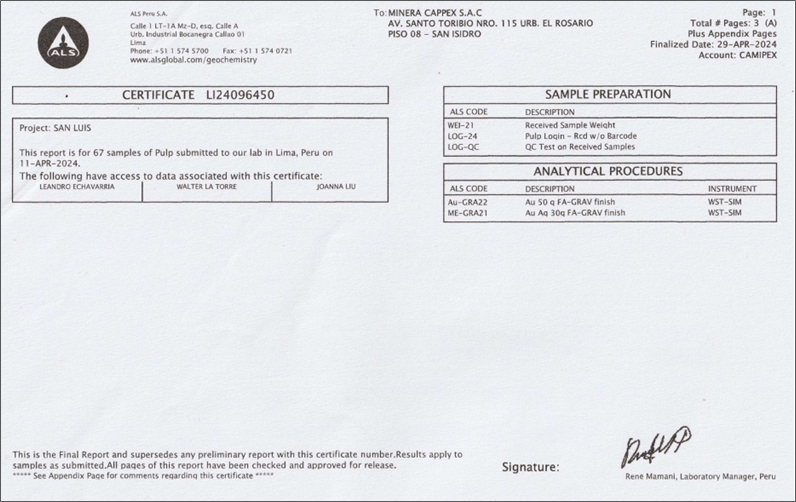
| Technical Report on the San Luis Property | 152 |
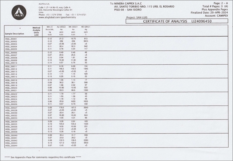
| Technical Report on the San Luis Property | 153 |
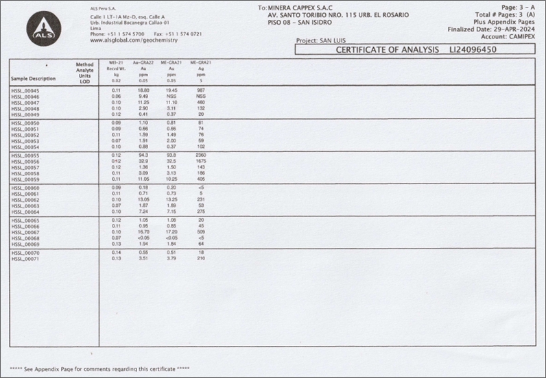
| Technical Report on the San Luis Property | 154 |
| Technical Report on the San Luis Property | 155 |
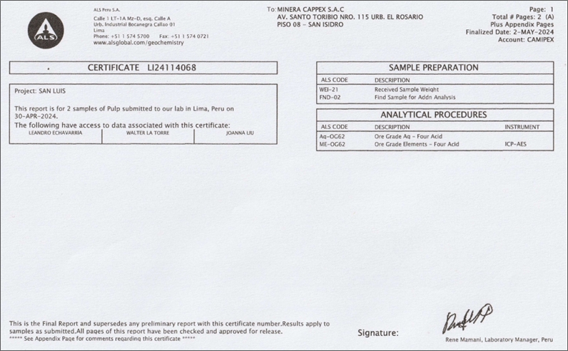
| Technical Report on the San Luis Property | 156 |
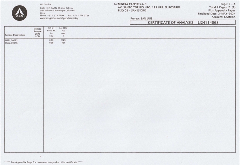
| Technical Report on the San Luis Property | 157 |
| Technical Report on the San Luis Property | 158 |